- Joined
- May 5, 2012
- Messages
- 1,732
Much of my interest in literature the last several years has turned western. Not to the fantasy west of L'amore but to a more authentic, at times historical, west. The west of beaver traps and uranium booms instead of eastern tribes and midwestern cowpokes transplanted into the scenery of the true west. The west of cutting rivers and mid-winter wagon trains across forlorn mesas.
Powell's account of his journeys down the Green and Colorado pushed me into Stegner's non-fiction. Then, by natural progression, his fiction. I sought out other stories of the river, learning more about the lands drowned by the impounded Green at Flaming Gorge. The characters who called Brown's Hole home. The Wild Bunch.
Along the way, I started feeling guilty for failing to further explore some of the river segments between the dams at Red and Glen Canyons. The river between Reclamation.
I've never set eyes on the Gates of Lodore. Nor had I seen the sea of sage leading into Echo Park.
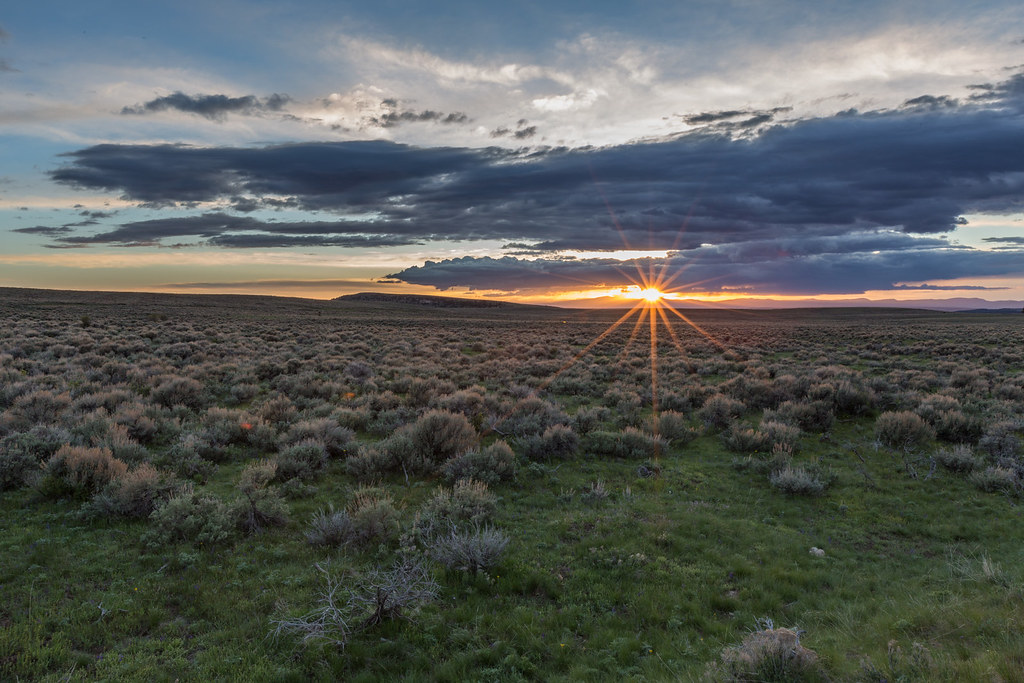 Sage in Season by ashergrey, on Flickr
How Dinosaur evaded my attention for more than 30 years of living and exploring Utah, I'm not exactly sure. Maybe it's because the monument exists mostly on the Colorado side of the border. Maybe it's because no one raves about the hikes and, lacking proper river experience and courage, places like Hell's Half Mile terrify me.
Were it not for a dramatic display of fossils, Dinosaur would probably receive just a fraction of its current visitation. Still, a busy day at Dinosaur likely falls short of the numbers at places like Zion, on their even slow days.
While Arches recorded its highest-ever visitation over Memorial Day 2014 (Abbey would be fuming), I instead headed east on U.S. 40.
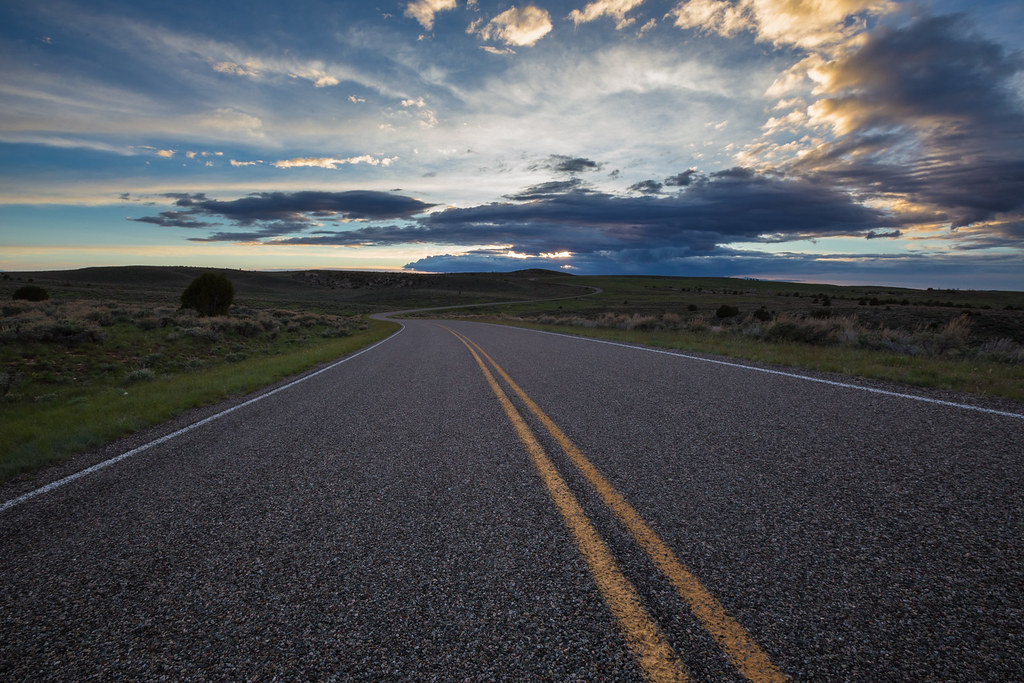 Harpers Corner Scenic Drive by ashergrey, on Flickr
I was late getting out of Salt Lake on Saturday afternoon and didn't pull onto the Harper's Corner Road until right about sundown. Skies were dramatic with layers of clouds.
 Halfway to Harper by ashergrey, on Flickr
While I'd hoped to make it all the way out to the end of the pavement to shoot sunset, it just didn't happen. Still, there were a few inspiring sights along the way.
This little pond caught my eye from the road. I had to go down an embankment and slip through a barbed-wire fence in order to catch the fleeting color's reflection.
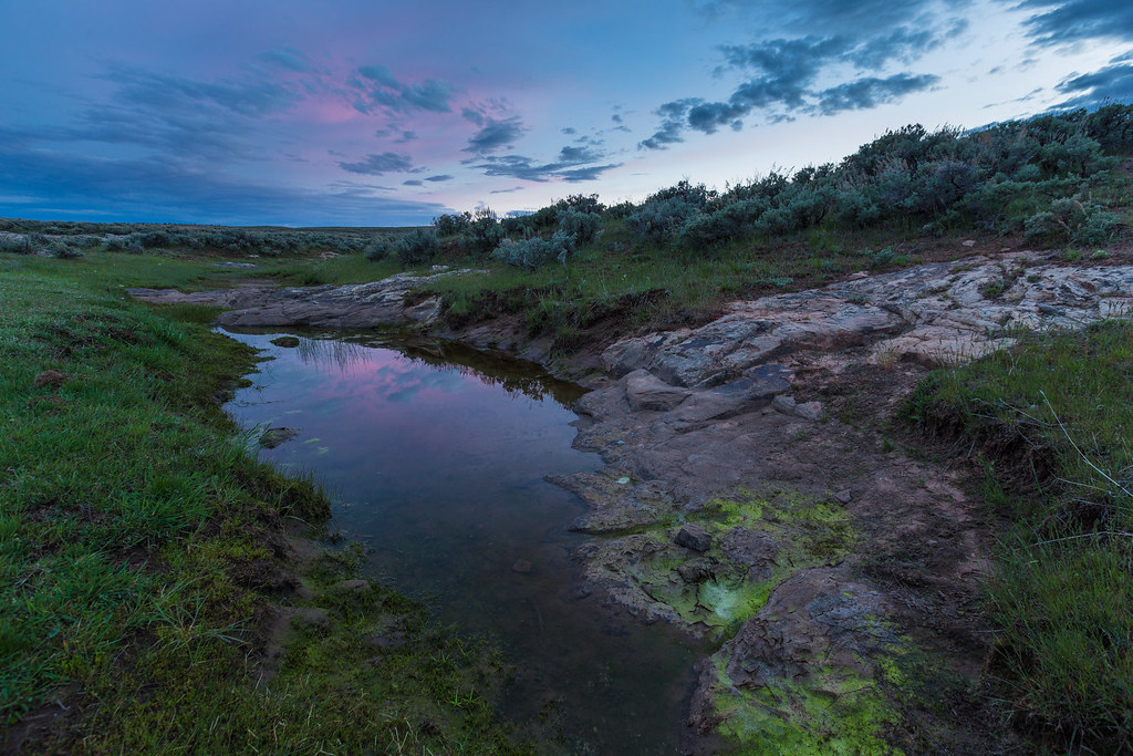 Dinosaur Pond by ashergrey, on Flickr
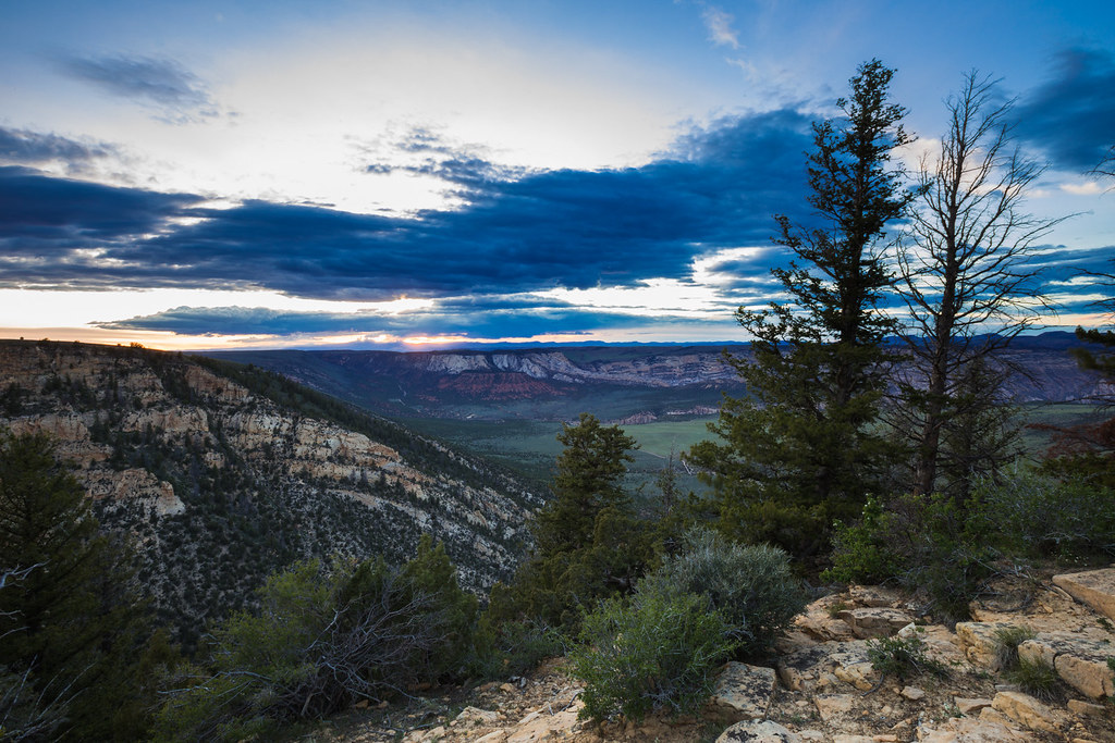
There were no other cars present at Harper's Corner by the time I arrived. The sun had already slipped entirely below the western horizon so I rolled out the bed roll in the back of the wagon and prepared to spend the night.
I set up for some night shots but clouds moved in and spoiled the scene. Not to mention there's a lot more light pollution rising from Vernal than I'd expected.

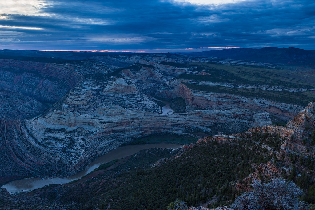
The real motive for this outing had lurked in the back of my mind for awhile. Stories of the river played their part in motivating me, but beyond that a mental image of one certain scene called to me: the eastward view from Harper's Corner looking down on the gorges of the Green and Yampa.
I could see from Google Earth that it begged for a dramatic sunrise. Certainly someone willing to rise early and stake out a lens could capture gold there.
Well, it didn't exactly work out that way.
As I hiked out in the cold of predawn on Sunday, the sky started to light. My hopes, already riding high with me on the rocky trail at 7,600 feet, rose even higher. This was going to be good.

Giddy, I jogged along the path to get in position. But just as the color seemed ready to pour over the cusp of the landscape, painting the twisted geologic layers in vibrant hues, clouds thickened. They blotted out the disc of the sun entirely. The light flattened and fizzled like a firework that sputters and dies once the fuse expires.
 Steamboat Sunrise by ashergrey, on Flickr
Pouting, I felt cheated and chilly.
 Wrong Side of the Rail by ashergrey, on Flickr
It seems somewhat petty now upon looking back, considering the landscape still proved worthy of awe. And I had it all to myself. Could anyone at Arches have said the same that morning?
I hung around awhile waiting for a breakout but it wasn't to be. Sun graced lands to the west with its light. I could see Marsh Peak some 45 miles distant lit up by its rays.

Not Echo Park though.

Nor Whirlpool Canyon.

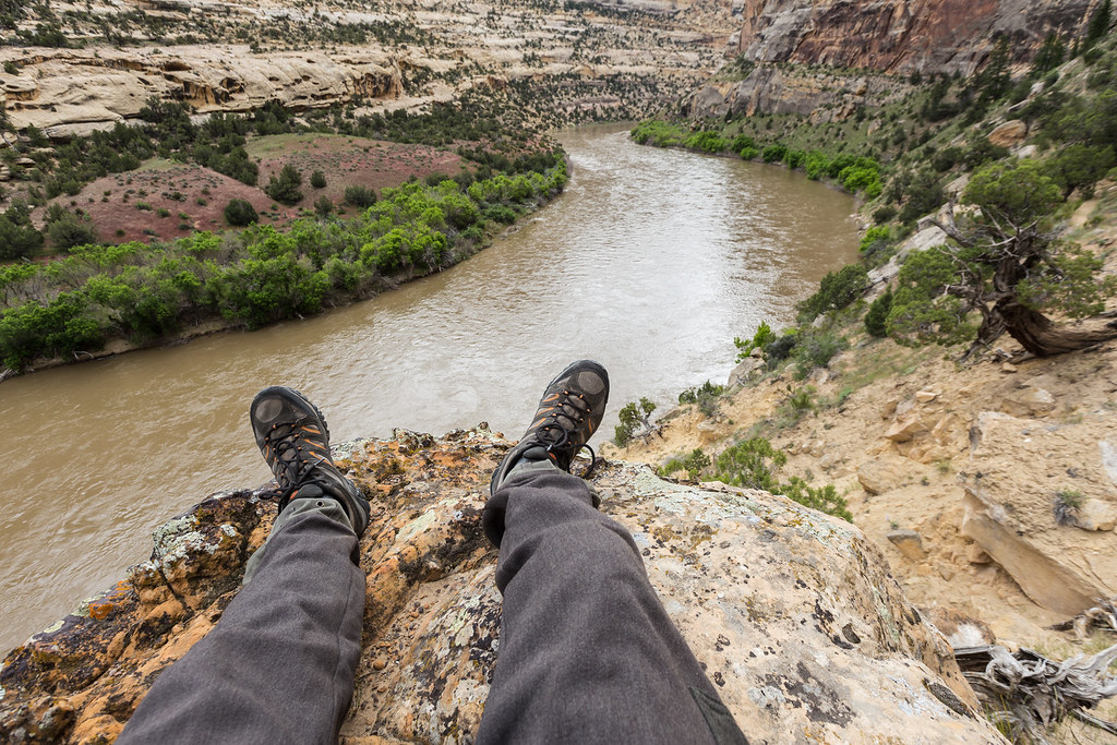
The river made a soft murmur from half a mile below, its rapids looking like mere riffles from my height. I toed the edge of the narrow neck of land on the wrong side of the guard rail.
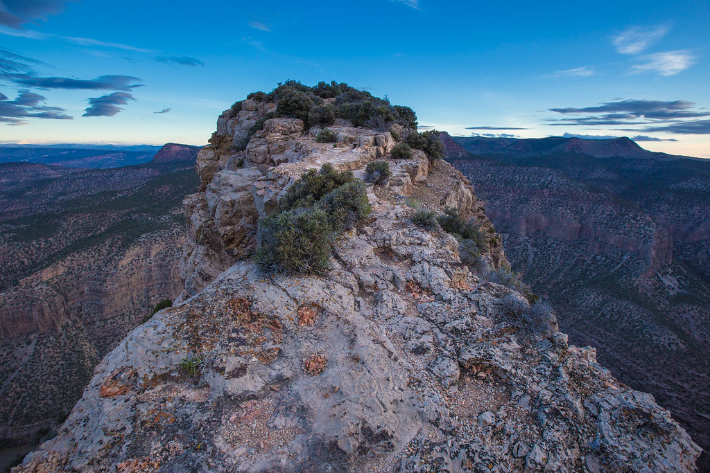 Dinosaur Spine by ashergrey, on Flickr
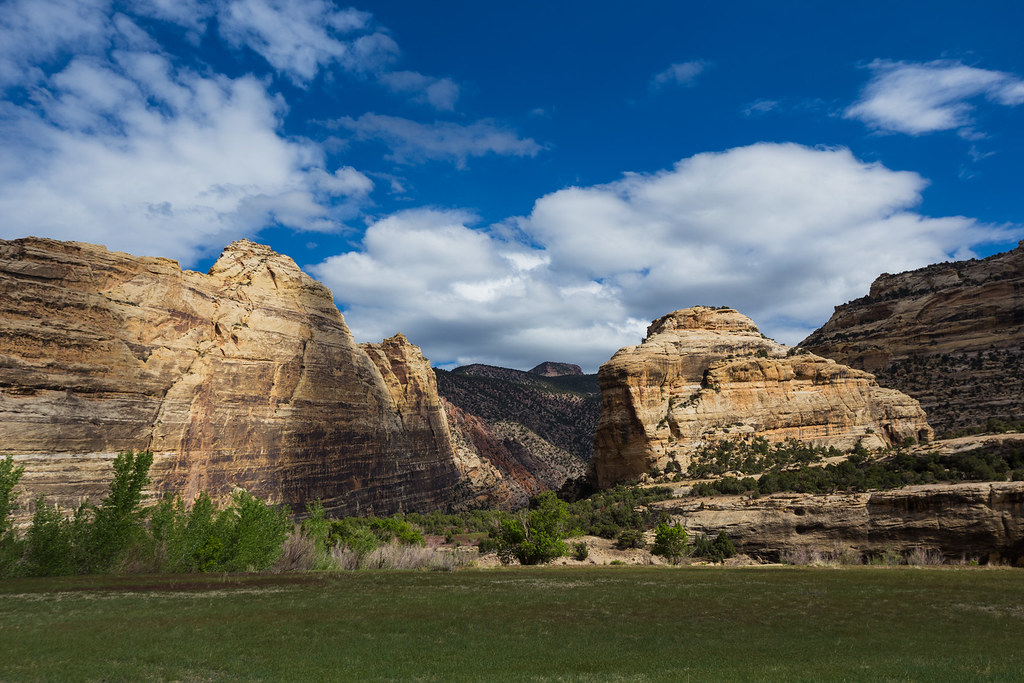
The air at last started to warm on the pleasant walk back to the car through old growth pinyon forest. Having been skunked, I decided to take a drive down into Echo Park proper. This was, after all, the land we as a nation sacrificed Glen Canyon and Flaming Gorge to save. What good is that sacrifice if people of my generation don't at least have some sense of the price paid in that devil's deal?
 The Egress of Lodore by ashergrey, on Flickr
Echo Park certainly has its beauty. It doesn't deserve to be denuded and drowned. But it's hard to stand in its thick grasses, field mice and garter snakes scampering or slithering unseen at your feet, and not wonder why the lower Escalante had to die to protect it.
How many people would today float a free-flowing Colorado under Glen Canyon's big walls were Steamboat Rock instead sitting in a still water bay?

Would we mourn the same way for Lodore and the twisting Yampa as we do for Powell's (the man, not the lake) Glen Canyon? I suppose we would.
Reading the National Park Service's 1946 "Survey of the Recreational Resources of the Colorado River Basin" provides insight to the thinking of the time.
We have the benefit of hindsight now in examining the trade-offs made to develop the water resources of the west. Even Lake Powell as we know it fell short of original government intentions.
Of course, sacrificing Glen Canyon didn't just buy Echo Park. It saved a great stretch of the Grand Canyon from inundation by establishing the policy that no reservoirs would be created within the boundaries of existing parks or monuments.
These are the thoughts that occupied my mind while walking under the looming faces of Steamboat and Jenny Lind.


The riparian ecosystem here feels untouched. Elk scat coats the ground. Tracks leading through the sand and cobbles to the river banks weave in complicated tangles, making it unclear just how many animals have wandered the river bottoms since the last rain or flood. The sound of annoyed Canada Geese echoes off the smooth rock walls.
[PARSEHTML]<audio controls><source src="https://dl.dropboxusercontent.com/u/3847512/Geese.mp3">Your browser does not support HTML5.</audio>[/PARSEHTML]
I'd read of a backpacking route up Sand Canyon from the Yampa's banks. Unfortunately, this was not the trip for such an excursion. I was only a week out from eye surgery and had doctor's orders to take it easy. Instead, I strolled along the banks of the last free-flowing river in the Colorado drainage system, admiring its unimpaired high runoff flow. The water appeared to be at bankfull.

While free of named rapids, the turbid water churned in complex hydraulics as it rushed by below me. I could see the brown soup rolling and folding on itself, turning back in recirculating currents.
 Break Above the Yampa by ashergrey, on Flickr
Clouds soon gathered, warning of rain to come. Taking the hint, I turned back toward the confluence and my waiting car at Echo Park.

While the area now enjoys relative protection under the Interior Department, one has to respect the ranchers who so briefly made these rugged lands home.
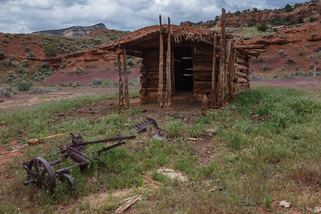 Real Estate by ashergrey, on Flickr
Especially when that meant passing on not only electricity, but also porcelain.
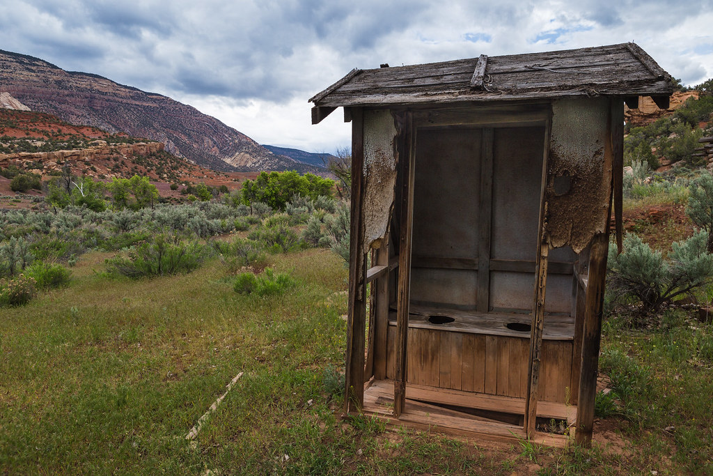 Privy by ashergrey, on Flickr
Having now seen it, I'm glad it's not under water. But I still haven't seen the Gates of Lodore.
Featured image for home page:

Powell's account of his journeys down the Green and Colorado pushed me into Stegner's non-fiction. Then, by natural progression, his fiction. I sought out other stories of the river, learning more about the lands drowned by the impounded Green at Flaming Gorge. The characters who called Brown's Hole home. The Wild Bunch.
Along the way, I started feeling guilty for failing to further explore some of the river segments between the dams at Red and Glen Canyons. The river between Reclamation.
I've never set eyes on the Gates of Lodore. Nor had I seen the sea of sage leading into Echo Park.
Sage in Season by ashergrey, on FlickrHow Dinosaur evaded my attention for more than 30 years of living and exploring Utah, I'm not exactly sure. Maybe it's because the monument exists mostly on the Colorado side of the border. Maybe it's because no one raves about the hikes and, lacking proper river experience and courage, places like Hell's Half Mile terrify me.
Were it not for a dramatic display of fossils, Dinosaur would probably receive just a fraction of its current visitation. Still, a busy day at Dinosaur likely falls short of the numbers at places like Zion, on their even slow days.
While Arches recorded its highest-ever visitation over Memorial Day 2014 (Abbey would be fuming), I instead headed east on U.S. 40.
Harpers Corner Scenic Drive by ashergrey, on FlickrI was late getting out of Salt Lake on Saturday afternoon and didn't pull onto the Harper's Corner Road until right about sundown. Skies were dramatic with layers of clouds.
Halfway to Harper by ashergrey, on FlickrWhile I'd hoped to make it all the way out to the end of the pavement to shoot sunset, it just didn't happen. Still, there were a few inspiring sights along the way.
This little pond caught my eye from the road. I had to go down an embankment and slip through a barbed-wire fence in order to catch the fleeting color's reflection.
Dinosaur Pond by ashergrey, on FlickrThere were no other cars present at Harper's Corner by the time I arrived. The sun had already slipped entirely below the western horizon so I rolled out the bed roll in the back of the wagon and prepared to spend the night.
I set up for some night shots but clouds moved in and spoiled the scene. Not to mention there's a lot more light pollution rising from Vernal than I'd expected.
The real motive for this outing had lurked in the back of my mind for awhile. Stories of the river played their part in motivating me, but beyond that a mental image of one certain scene called to me: the eastward view from Harper's Corner looking down on the gorges of the Green and Yampa.
I could see from Google Earth that it begged for a dramatic sunrise. Certainly someone willing to rise early and stake out a lens could capture gold there.
Well, it didn't exactly work out that way.
As I hiked out in the cold of predawn on Sunday, the sky started to light. My hopes, already riding high with me on the rocky trail at 7,600 feet, rose even higher. This was going to be good.
Giddy, I jogged along the path to get in position. But just as the color seemed ready to pour over the cusp of the landscape, painting the twisted geologic layers in vibrant hues, clouds thickened. They blotted out the disc of the sun entirely. The light flattened and fizzled like a firework that sputters and dies once the fuse expires.
Steamboat Sunrise by ashergrey, on FlickrPouting, I felt cheated and chilly.
Wrong Side of the Rail by ashergrey, on FlickrIt seems somewhat petty now upon looking back, considering the landscape still proved worthy of awe. And I had it all to myself. Could anyone at Arches have said the same that morning?
I hung around awhile waiting for a breakout but it wasn't to be. Sun graced lands to the west with its light. I could see Marsh Peak some 45 miles distant lit up by its rays.
Not Echo Park though.
Nor Whirlpool Canyon.
The river made a soft murmur from half a mile below, its rapids looking like mere riffles from my height. I toed the edge of the narrow neck of land on the wrong side of the guard rail.
Dinosaur Spine by ashergrey, on FlickrThe air at last started to warm on the pleasant walk back to the car through old growth pinyon forest. Having been skunked, I decided to take a drive down into Echo Park proper. This was, after all, the land we as a nation sacrificed Glen Canyon and Flaming Gorge to save. What good is that sacrifice if people of my generation don't at least have some sense of the price paid in that devil's deal?
The Egress of Lodore by ashergrey, on FlickrEcho Park certainly has its beauty. It doesn't deserve to be denuded and drowned. But it's hard to stand in its thick grasses, field mice and garter snakes scampering or slithering unseen at your feet, and not wonder why the lower Escalante had to die to protect it.
How many people would today float a free-flowing Colorado under Glen Canyon's big walls were Steamboat Rock instead sitting in a still water bay?
Would we mourn the same way for Lodore and the twisting Yampa as we do for Powell's (the man, not the lake) Glen Canyon? I suppose we would.
Reading the National Park Service's 1946 "Survey of the Recreational Resources of the Colorado River Basin" provides insight to the thinking of the time.
The dam would be totally alien to the geology and landscape of the monument. It would be seen from the upper end of Whirlpool Canyon and from points along the rims of the canyon, and, from the viewpoint of monument values, would be a lamentable intrusion.
Power lines would have a widely damaging effect upon wilderness and scenic values. Development of a power project would require the introduction of construction and operation roads and other facilities which would otherwise not be built. They could hardily be constructed without injury to geological and scenic values of the Canyon Unit.
Far-reaching effects upon scenic, geological, and wilderness values would result from impoundment of the Echo Park Reservoir. The two-arm artificial lake would cover wholly or in part a number of fine geological exposures, would reduce the visible height of canyon walls, and would substitute long bodies of still water, widening here and there into bays, for the characteristic rivers and fringing vegetation which now lie in canyon bottoms. The Canyon of Lodore would contain a narrow fiord-like lake which would inundate a portion of the exposed geological formations in the canyon bottoms. The same is true of the Yampa Canyon.
Particularly deplorable effects of the Echo Park Reservoir upon geological and wilderness features would occur in the localities of Pats Hole and Echo Park near the junction of the Green and Yampa Rivers and in Castle Park and Hardings Hole on the Yampa River. A large part of Pats Hole would be covered by the Echo Park Reservoir. The fine spring and Pats Cave where the interesting character, Pat Lynch, lived alone for many years, would be submerged. Even more unfortunate, would be the submersion of the floor of Echo Park, the great reduction in the visible height of the nearly vertical sandstone walls of Echo Park which rise several hundred feet above the floor, the inundation of about one-half of Steamboat Rock, and partial obliteration of noteworthy folds and faults so strikingly revealed in this area.
We have the benefit of hindsight now in examining the trade-offs made to develop the water resources of the west. Even Lake Powell as we know it fell short of original government intentions.
Of primary concern to the State and the Nation is the proper utilization of the natural resources of this vast area in southeastern Utah. The Colorado, Green, and San Juan Rivers offer opportunities for great power developments. In the comprehensive plan for the development of the water resources of the Colorado River Basin consideration is given by the Bureau of Reclamation to the possibility of constructing two large hydroelectric dams on the Colorado River; one, either at the Glen Canyon site 4 miles above Lees Ferry, Ariz., or at an alternate site 15 miles above Lees Ferry, and the other at the Dark Canyon site in Cataract Canyon, 3 miles above the mouth of Dark Canyon. These two dams would impound the Colorado River from just above Lees Ferry to Moab, Utah, a distance of 279 miles, and the lower 62 miles of the Green River. Tentative plans for the Glen Canyon site indicate that a dam 414 feet high would create a reservoir which at normal water surface elevation of 3,528 feet would have a surface area of 65,000 acres and a capacity of 8,600,000 acre-feet. The slack water would extend 186 miles up the Colorado to the Dark Canyon Dam site. There conditions are reported favorable for construction of a high dam which would back water to Moab and up the Green River.
The Glen Canyon site would be accessible from United States Highway 89, 131 miles by road north of Flagstaff, Ariz. The Dark Canyon site is at present inaccessible except by boat or horseback. The nearest automobile trail is at North Wash, 18 miles downstream.
There are three power site possibilities in the San Juan River Canyon below Mexican Hat—one in the Goosenecks of the San Juan, one near the mouth of Slickhorn Canyon, and the other in the Great Bend of the river.
The potential dams and reservoirs would eliminate the thrills of boating down the untamed rivers. The depths of the river canyons would be reduced. The deadly rapids of Cataract Canyon, responsible for the tragic ending of several canyon voyages, and the sand bars and the often shallow waters of Glen Canyon, would be gone. But the Glen Canyon Reservoir would provide access to the wonders of the canyons.
Of course, sacrificing Glen Canyon didn't just buy Echo Park. It saved a great stretch of the Grand Canyon from inundation by establishing the policy that no reservoirs would be created within the boundaries of existing parks or monuments.
These are the thoughts that occupied my mind while walking under the looming faces of Steamboat and Jenny Lind.
The riparian ecosystem here feels untouched. Elk scat coats the ground. Tracks leading through the sand and cobbles to the river banks weave in complicated tangles, making it unclear just how many animals have wandered the river bottoms since the last rain or flood. The sound of annoyed Canada Geese echoes off the smooth rock walls.
[PARSEHTML]<audio controls><source src="https://dl.dropboxusercontent.com/u/3847512/Geese.mp3">Your browser does not support HTML5.</audio>[/PARSEHTML]
I'd read of a backpacking route up Sand Canyon from the Yampa's banks. Unfortunately, this was not the trip for such an excursion. I was only a week out from eye surgery and had doctor's orders to take it easy. Instead, I strolled along the banks of the last free-flowing river in the Colorado drainage system, admiring its unimpaired high runoff flow. The water appeared to be at bankfull.
While free of named rapids, the turbid water churned in complex hydraulics as it rushed by below me. I could see the brown soup rolling and folding on itself, turning back in recirculating currents.
Break Above the Yampa by ashergrey, on FlickrClouds soon gathered, warning of rain to come. Taking the hint, I turned back toward the confluence and my waiting car at Echo Park.
While the area now enjoys relative protection under the Interior Department, one has to respect the ranchers who so briefly made these rugged lands home.
Real Estate by ashergrey, on FlickrEspecially when that meant passing on not only electricity, but also porcelain.
Privy by ashergrey, on FlickrHaving now seen it, I'm glad it's not under water. But I still haven't seen the Gates of Lodore.
Featured image for home page:
Last edited: