- Joined
- May 24, 2015
- Messages
- 179
It has been a while since I have written up a full report on a trip, rather than just post some pictures. This forum has turned me on to a lot of new trip ideas and helped me prepare for them. The trip I am writing about is a fairly generic Eastern Sierra trip. Hopefully, I can share some knowledge about this part of the Sierra and help someone else, if they are considering a similar trip. If there are too many words for you to bother with; than just skip thru to the pictures. They are the best part anyways.
California Highway 395 runs North South on the Eastern side of the Sierra Nevada Mountain range. Small towns, like Big Pine, Independence, Lone Pine, Bishop, Mammoth, and Bridgeport all have steep roads known to backpackers. The roads typically travel West, up an accessible Sierra canyon, providing recreation and trailhead access to all that the Sierra has to offer. The biggest of these towns is Bishop and the road leading West out of town goes up to the 9,000 foot level. This is where they put a dam on Bishop Creek and created Sabrina Lake back in 1907. The Sabrina Lakes Basin sits at about 1500 feet above this, starting with Blue Lake. The hike to Blue lake is a decent day hike for many people that live in the area. For backpackers not acclimated to the 9000 ft elevation, this part of the hike can be a slow exercise in breathing recovery, especially in the steeper switchbacks area. It is not uncommon for backpackers to adjust their itineraries and spend their first night at Blue lake, instead of moving on, This is a pretty common scenario for all Eastern Sierra trailheads. The first day of hiking, with a full pack on, and sea level lungs, is often a lot more of a struggle than expected. The paved asphalt roads typically fall short of getting to any of the Lakes basin elevations or beyond any of the mountain passes. The first six hours of hiking are almost always very vertical. These type of trailheads are not the best ones to be introducing someone new to backpacking.
My plan was to spend a few days, with no real agenda, wandering around up in the Sabrina Lakes basin and then hike out the same way I came in.

I chose a mid July start time in an effort to catch a lot of spring flowers for better photography opportunities. I was also trying to avoid high water levels from any spring runoff, as well as avoid the peak of mosquito season. I was able to get a required overnight camping permit online from the Inyo National forest, using the Recreation.gov website. Printing out the permit at home meant I could get a real early start, since I would not have stop at any ranger stations.
When time permits, I also like to arrive to the mountains early and do a high altitude day hike before the actual backpacking. This is helpful if you have anyone new with you. It is good to shake out any high altitude hiking issues without a full pack on. I was really excited for the day hike that I had planned. There is another high altitude trailhead access called the Rock Creek road. It is also near the Bishop area. Rock Creek road is one of those rare Sierra trailhead access roads that has no town below it, on highway 395. It is situated between Bishop and Mammoth Lakes, with a turnout that is just called Tom's Place. The Rock Creek road goes really high, up to 10,200 feet. The Mosquito Flats trailhead, at the end of the road, provides instant access to the Little Lakes Basin. Some of these lakes are known to have pure strain, California Golden Trout (the state fish!). I have caught Golden trout before, in other high Sierra lakes, but they were probably all a little hybridized with rainbow trout, since both species were present in the other lakes I had fished. The Little Lakes area is known to have some lakes that have pure Goldens, no hybridization. I was hoping to see what a true Golden looked like compared to what I had caught before.
I got an early start on my day hike by parking and sleeping at the trailhead after arriving around midnight.

Compared to the valley floor below, it was nice and cool in the morning at 11,000 ft.

The trail was gently sloping uphill towards the many lakes in the area.
A good variety of flowers were blooming.
Eventually I left the trail and went cross country to find some isolated lakes.
I was less than 4 miles from my car that I found a lake with the pure Goldens in it. I pulled a couple of them in and noticed right away that they were almost red on the bottom. I followed catch and release, used single barbless hooks and fully wetted my hand and glove before picking them up. After safely releasing the ones in the pictures, I caught a few more and was able to shake them off the hook without having them leave the water. It was a bucket list item fulfilled for me. Not necessarily to catch them, but to see them up close and being table to admire them, without permanently harming them. They only live in these high altitude Sierra lakes that are not easy to get to.

There were flowers everywhere.

Seeing those fish up close was the highlight of the day. Now I was excited to hike back down to the car and drive over to the backpacking trailhead at Sabrina Lake. There was a Robin asking for its picture to be taken on the way back.


I spent most of the day up in that Little Lakes area exploring other lakes. Then I headed to the car and drove back to Bishop.
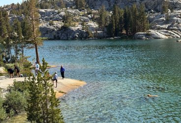
There is no overnight parking allowed near the Sabrina Lakes Basin trailhead. It is best to drop off the hikers and all of the packs and have someone drive the quarter mile back down the road to park the car outside the Sabrina campground. Also, there is very little (none for me) cell service once you leave Bishop, for the 17 mile drive up to the trailhead. Make sure you have your maps downloaded ahead of time if you are using a gps tool for navigating.
The trailhead looks like a jeap road on the left. It is not marked very well but the road ends at the marina shortly after this.

I was on the trail early on a Sunday. It was a clear gorgeous day and not hot yet.


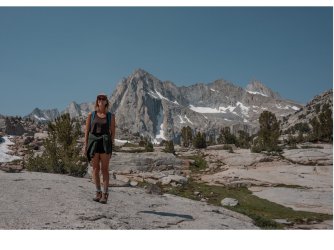
As seen on the map, the trail skirts the dam and Sabrina Lake to the South, gaining the needed altitude to get up to Blue lake. The views got impressive real fast. Very quickly I was looking down on the Lake.

These red looking peaks become visible over the lake area as you get higher.
Also very quickly, I noticed I was going really slow and breathing hard. I did a mental checklist; are my boots okay, my knees, my hips, is it too hot out, am I staying hydrated, am I letting the mosquitoes bother me, do I have too much weight in my pack or is it just too steep (or is my age catching up to me) ? Of course, after considering all of these factors, I knew what the answer was all along. My lungs were still back at sea level, and there was not much I could do about it, except to economize my exertion. I find if I avoid taking tall steps and keep a slow pace I can go a lot further up a hill before needing to let my breathing and heart rate recover. It may not look very athletic but shuffling along with short steps limits my exertion. For quick rest, I like to find a rock to sit on that supports the weight of my backpack, giving my shoulders and hips a break as well as my heart and lungs. After about a minute I can continue and I often feel fully rejuvenated without having removed my pack.
When I got to the steep switchbacks heading up to Blue lake I was stopping quite frequently. As soon as I could feel my heart rate and breathing slow back down I stood up and continued on the trail. There was no sense complaining or thinking about the weight I had packed. I just recognized my condition as the price you pay on the first day of an Eastern Sierra backpack hike. Being a sea level weekend warrior, you will not have been acclimatized to the altitude and it will have its affect when going steeply uphill. Eventually, I got into a rhythm and soon I was at the outflow of Blue lake.

There were a few people camped at Blue and some day hikers had passed me on the way up. I was glad to have the bulk of the climb behind me. Moving from lake to lake would be a lot easier now that I had the major climb out of the way.
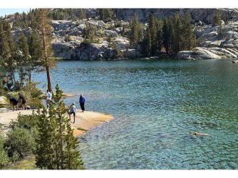
Blue lake is really clear. It is a good swimming lake with some fun jumping perches.
The trail after Blue lake continued up but at a more even, undulating way. I was able to hike faster and with fewer breath stops. There were a lot fewer day hikers interested to go beyond Blue lake.
This basin has the most whimsical lake names in the Sierra. My next stop was going to be Dingleberry lake, beyond that would be Topsy-turvey lake and at the end of the trail would be Hungry Packer lake.
I was confused about which way to go.......am I a Dingleberry or a Donkey kind of person.

The inflow for Dingleberry lake has a good rock hop crossing.

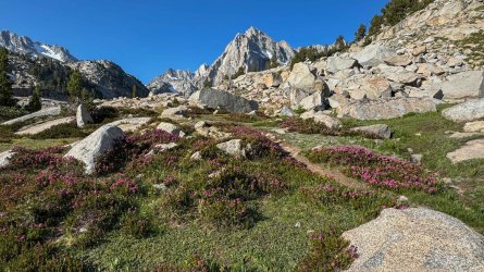
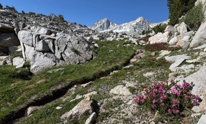
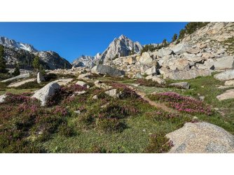
The vistas were getting real good.

The trail is very interesting with some forest, some granite walls, some flowers and some flowing creeks.
Eventually Moonlight Falls came into view in the distance.

This place looked so awesome and had no one around it. I set up my tent nearby and gladly took off my pack for a couple of days.
 One of the best campsite vistas I have ever experienced. Moonlight falls and Picture Peak make a great combination.
I got up early the next day and had a fun photo session with the Falls.

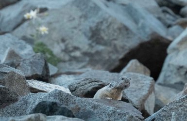
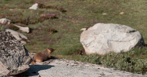
 Later, I went out hiking towards another lake when I found a steep bank of granite blocks. It was perfect habitat for the North American Pika. They make a loud pair of cheep cheep calls before you see them. Then you look for movement or maybe spot them staring out from a rock perch. They are very well adapted to the high altitudes. They don’t hibernate in winter. Instead, they move around in tunnels within the snow covered rock piles, feeding on the grasses that they have stored all summer long.
They are sometimes called the rock rabbit. This one certainly looks the name.

This rock pile had a number of them spread out. They are really fast and very entertaining. I watched them for a long time. Every once in a while one would appear right in front of me.
I could watch them all day. That is one of the things I like about having no agenda. For me the best part of backpacking is putting down the full pack and enjoying multiple layover days. From the same spot. If I want to go find an unnamed mountain to scramble up for the afternoon I could do that. Or do a technical climb of a named mountain. Or perhaps just go cross country to an unnamed lake and try fishing in it. On this trip I spent a lot of time observing wildlife and lounging around the awesome waterfall with a swimming hole right in front of it.
Every year I follow some of the PCT thru hikers that put up such awesome content as they hike continuously for many days. They start in my county, we have over 100 miles of PCT. They make a lot of sacrifices to complete their overall journey to Canada. They often hike 20-30 miles a day to stay on a set schedule. I cringe when I see them skim through some places that I know are the best part of the Sierra. At least most of them stop to climb Mount Whitney but there is a lot more off trail from the PCT that they do not get to experience. Many times I see them take a layover day in a resupply town where they can shower and eat a real meal. Kind of a waste of a layover day if you ask me. Those days should be better spent without your pack on, in the heart of the high country.
I applaud thru hikers for their achievements and tenacity but they get a lot of attention by new hikers. New hikers need to realize that thru hiking long distances is just a subset of backpacking. It probably should not be the first type of backpacking to try. A lot of hopes get dashed and PCT’ers get rescued during the first week of a PCT thru hike attempt near the border, where it is a hot desert environment even In the late spring months. Hopefully those folks don’t give up their interest in backpacking entirely.
Many of us just use backpacking as a means to get to the high country and park and do our thing. This trip made it abundantly clear to me why I value backpacking. It is not the act of actually carrying everything with me, day after day. It is what I do once I arrive and set up a camp.
Video slowed down half speed.
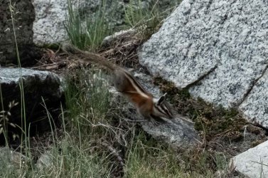
After having the Pikas play whack a mole with me and my camera, something cool happened.
I saw a different movement out of the corner of my eye. It moved as fast as a Pika, but it had a long tail.

After darting down thru the rocks many times toward me, I was able to identify it as a Sierra Marten.

Now I had two cool experiences going on at the same time. The Marten came very close to me and kept popping its head out. They are very curious. They are even quicker than the Pikas. Unlike the vegetarian Pikas, Martens are capable carnivores. They are often active at night. I would not have seen this particular individual if I had been up here on a day hike. I would have arrived too late. It was backpacking that allowed me to find this individual, in the early morning hours, as the sun came up in his morning territory.
Video slowed down to half speed.
That night I tried my hand at shooting the milky way but it wasn’t co operating . So I made the best of the situation with some flashlight painting before the moon showed up later that evening.

My daughter was working nearby in Mammoth. She could not join me for the start of the hike but I was expecting her to arrive one of the later days between noon and 4pm. Imagine my surprise when she is the first person I had seen in 36 hours. She shows up at my campsite at 10:30 am with just a daypack . Living at 8000 feet allowed her to be acclimated for the uphill hike at 10,000 feet. She dayhiked up with a small pack in 3.5 hours. It had taken me 7 with a full pack. She had made such quick time that I suddenly didn’t even feel like I was in the “backcountry”.
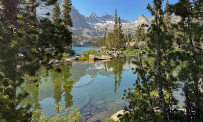
 We hiked over to some more of the nearby Lakes. I showed her the waterfall and swimming hole.

My last day I found some more beautiful vistas to explore.
 Hungry Packer Lake has a incredible mountain backdrop behind it. Some ground snow had recently melted so It was marshy, and full of active mosquitos in the early morning hours.

Hungry Packer Lake with a waning moon.
Kelley hiked back down late in the afternoon, to go get ready for her backcountry job.
I found some more subjects to point my camera at.


That night I tried some more long exposures, this time with no help from the flashlight. Pretty similar.

My hike out was uneventful. Going downhill was easy. I came back the same way I had come up.

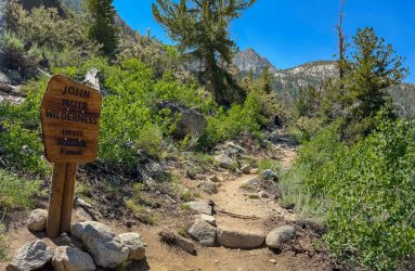
At one point I came across this sign . I had to get a picture! In a place that had so many zany lake names this one fit right in.

I once worked with a Lead engineer, Max, that was put in charge of a group of new hire, young engineers. He could never remember any of our names. We probably all seemed the same to him, young and inexperienced. I finally told him to make it easy on everyone and just call us George. Not George 1 , George 2, just call each of us George. He would only have to remember one name. It caught on, and soon we were arriving in the morning to a continuous round of us greeting each other, hey George, good morning George, whats up George. Max would even go to meetings and tell his superiors that he could get a project done on time : I’ll take it back to the Georges, they will figure it out. The four of us even started referring to each other as George, outside of work. It was a running joke that lasted a long time, even after all we changed jobs.
So I had to take this picture and send it to the other Georges.
Now this trail has me wondering if I am a Dingleberry, a Donkey, a Hungry Packer, or a George. Probably all four.
The remaining trip down the mountain was so fun because it was so easy. I talked to a couple of backpackers that were struggling to go up the switchbacks. I told them about my similar experience on the way up a few days earlier. I found out that they were also coming from sea level, so I gave them some words of encouragement and advice. Take it easy, go slower . Don’t push yourself to the point of getting a headache. Which one girl already had done. I talked with her until she felt better. Water and rest got her back on the uphill attack in few short minutes.

As I got to my car I reflected on what a great trip I had just pulled off. Why do I only do one trip per summer? Next summer I should do more trips. Then I started thinking way outside my box and decided I should consider staying in Mammoth a couple of months next summer. Get acclimated like Kelley was and do day hikes and backpack trips all around the area. Eliminate the driving, the difficulty breathing, being able to choose the proper weather window. Become a local for a few months. Hmmmm……..
Thanks for reading.
TV
California Highway 395 runs North South on the Eastern side of the Sierra Nevada Mountain range. Small towns, like Big Pine, Independence, Lone Pine, Bishop, Mammoth, and Bridgeport all have steep roads known to backpackers. The roads typically travel West, up an accessible Sierra canyon, providing recreation and trailhead access to all that the Sierra has to offer. The biggest of these towns is Bishop and the road leading West out of town goes up to the 9,000 foot level. This is where they put a dam on Bishop Creek and created Sabrina Lake back in 1907. The Sabrina Lakes Basin sits at about 1500 feet above this, starting with Blue Lake. The hike to Blue lake is a decent day hike for many people that live in the area. For backpackers not acclimated to the 9000 ft elevation, this part of the hike can be a slow exercise in breathing recovery, especially in the steeper switchbacks area. It is not uncommon for backpackers to adjust their itineraries and spend their first night at Blue lake, instead of moving on, This is a pretty common scenario for all Eastern Sierra trailheads. The first day of hiking, with a full pack on, and sea level lungs, is often a lot more of a struggle than expected. The paved asphalt roads typically fall short of getting to any of the Lakes basin elevations or beyond any of the mountain passes. The first six hours of hiking are almost always very vertical. These type of trailheads are not the best ones to be introducing someone new to backpacking.
My plan was to spend a few days, with no real agenda, wandering around up in the Sabrina Lakes basin and then hike out the same way I came in.
I chose a mid July start time in an effort to catch a lot of spring flowers for better photography opportunities. I was also trying to avoid high water levels from any spring runoff, as well as avoid the peak of mosquito season. I was able to get a required overnight camping permit online from the Inyo National forest, using the Recreation.gov website. Printing out the permit at home meant I could get a real early start, since I would not have stop at any ranger stations.
When time permits, I also like to arrive to the mountains early and do a high altitude day hike before the actual backpacking. This is helpful if you have anyone new with you. It is good to shake out any high altitude hiking issues without a full pack on. I was really excited for the day hike that I had planned. There is another high altitude trailhead access called the Rock Creek road. It is also near the Bishop area. Rock Creek road is one of those rare Sierra trailhead access roads that has no town below it, on highway 395. It is situated between Bishop and Mammoth Lakes, with a turnout that is just called Tom's Place. The Rock Creek road goes really high, up to 10,200 feet. The Mosquito Flats trailhead, at the end of the road, provides instant access to the Little Lakes Basin. Some of these lakes are known to have pure strain, California Golden Trout (the state fish!). I have caught Golden trout before, in other high Sierra lakes, but they were probably all a little hybridized with rainbow trout, since both species were present in the other lakes I had fished. The Little Lakes area is known to have some lakes that have pure Goldens, no hybridization. I was hoping to see what a true Golden looked like compared to what I had caught before.
I got an early start on my day hike by parking and sleeping at the trailhead after arriving around midnight.
Compared to the valley floor below, it was nice and cool in the morning at 11,000 ft.
The trail was gently sloping uphill towards the many lakes in the area.
A good variety of flowers were blooming.
Eventually I left the trail and went cross country to find some isolated lakes.
I was less than 4 miles from my car that I found a lake with the pure Goldens in it. I pulled a couple of them in and noticed right away that they were almost red on the bottom. I followed catch and release, used single barbless hooks and fully wetted my hand and glove before picking them up. After safely releasing the ones in the pictures, I caught a few more and was able to shake them off the hook without having them leave the water. It was a bucket list item fulfilled for me. Not necessarily to catch them, but to see them up close and being table to admire them, without permanently harming them. They only live in these high altitude Sierra lakes that are not easy to get to.
There were flowers everywhere.
Seeing those fish up close was the highlight of the day. Now I was excited to hike back down to the car and drive over to the backpacking trailhead at Sabrina Lake. There was a Robin asking for its picture to be taken on the way back.
I spent most of the day up in that Little Lakes area exploring other lakes. Then I headed to the car and drove back to Bishop.
There is no overnight parking allowed near the Sabrina Lakes Basin trailhead. It is best to drop off the hikers and all of the packs and have someone drive the quarter mile back down the road to park the car outside the Sabrina campground. Also, there is very little (none for me) cell service once you leave Bishop, for the 17 mile drive up to the trailhead. Make sure you have your maps downloaded ahead of time if you are using a gps tool for navigating.
The trailhead looks like a jeap road on the left. It is not marked very well but the road ends at the marina shortly after this.
I was on the trail early on a Sunday. It was a clear gorgeous day and not hot yet.
As seen on the map, the trail skirts the dam and Sabrina Lake to the South, gaining the needed altitude to get up to Blue lake. The views got impressive real fast. Very quickly I was looking down on the Lake.
These red looking peaks become visible over the lake area as you get higher.
Also very quickly, I noticed I was going really slow and breathing hard. I did a mental checklist; are my boots okay, my knees, my hips, is it too hot out, am I staying hydrated, am I letting the mosquitoes bother me, do I have too much weight in my pack or is it just too steep (or is my age catching up to me) ? Of course, after considering all of these factors, I knew what the answer was all along. My lungs were still back at sea level, and there was not much I could do about it, except to economize my exertion. I find if I avoid taking tall steps and keep a slow pace I can go a lot further up a hill before needing to let my breathing and heart rate recover. It may not look very athletic but shuffling along with short steps limits my exertion. For quick rest, I like to find a rock to sit on that supports the weight of my backpack, giving my shoulders and hips a break as well as my heart and lungs. After about a minute I can continue and I often feel fully rejuvenated without having removed my pack.
When I got to the steep switchbacks heading up to Blue lake I was stopping quite frequently. As soon as I could feel my heart rate and breathing slow back down I stood up and continued on the trail. There was no sense complaining or thinking about the weight I had packed. I just recognized my condition as the price you pay on the first day of an Eastern Sierra backpack hike. Being a sea level weekend warrior, you will not have been acclimatized to the altitude and it will have its affect when going steeply uphill. Eventually, I got into a rhythm and soon I was at the outflow of Blue lake.
There were a few people camped at Blue and some day hikers had passed me on the way up. I was glad to have the bulk of the climb behind me. Moving from lake to lake would be a lot easier now that I had the major climb out of the way.
Blue lake is really clear. It is a good swimming lake with some fun jumping perches.
The trail after Blue lake continued up but at a more even, undulating way. I was able to hike faster and with fewer breath stops. There were a lot fewer day hikers interested to go beyond Blue lake.
This basin has the most whimsical lake names in the Sierra. My next stop was going to be Dingleberry lake, beyond that would be Topsy-turvey lake and at the end of the trail would be Hungry Packer lake.
I was confused about which way to go.......am I a Dingleberry or a Donkey kind of person.
The inflow for Dingleberry lake has a good rock hop crossing.
The vistas were getting real good.
The trail is very interesting with some forest, some granite walls, some flowers and some flowing creeks.
Eventually Moonlight Falls came into view in the distance.
This place looked so awesome and had no one around it. I set up my tent nearby and gladly took off my pack for a couple of days.
One of the best campsite vistas I have ever experienced. Moonlight falls and Picture Peak make a great combination.I got up early the next day and had a fun photo session with the Falls.
Later, I went out hiking towards another lake when I found a steep bank of granite blocks. It was perfect habitat for the North American Pika. They make a loud pair of cheep cheep calls before you see them. Then you look for movement or maybe spot them staring out from a rock perch. They are very well adapted to the high altitudes. They don’t hibernate in winter. Instead, they move around in tunnels within the snow covered rock piles, feeding on the grasses that they have stored all summer long.They are sometimes called the rock rabbit. This one certainly looks the name.
This rock pile had a number of them spread out. They are really fast and very entertaining. I watched them for a long time. Every once in a while one would appear right in front of me.
I could watch them all day. That is one of the things I like about having no agenda. For me the best part of backpacking is putting down the full pack and enjoying multiple layover days. From the same spot. If I want to go find an unnamed mountain to scramble up for the afternoon I could do that. Or do a technical climb of a named mountain. Or perhaps just go cross country to an unnamed lake and try fishing in it. On this trip I spent a lot of time observing wildlife and lounging around the awesome waterfall with a swimming hole right in front of it.
Every year I follow some of the PCT thru hikers that put up such awesome content as they hike continuously for many days. They start in my county, we have over 100 miles of PCT. They make a lot of sacrifices to complete their overall journey to Canada. They often hike 20-30 miles a day to stay on a set schedule. I cringe when I see them skim through some places that I know are the best part of the Sierra. At least most of them stop to climb Mount Whitney but there is a lot more off trail from the PCT that they do not get to experience. Many times I see them take a layover day in a resupply town where they can shower and eat a real meal. Kind of a waste of a layover day if you ask me. Those days should be better spent without your pack on, in the heart of the high country.
I applaud thru hikers for their achievements and tenacity but they get a lot of attention by new hikers. New hikers need to realize that thru hiking long distances is just a subset of backpacking. It probably should not be the first type of backpacking to try. A lot of hopes get dashed and PCT’ers get rescued during the first week of a PCT thru hike attempt near the border, where it is a hot desert environment even In the late spring months. Hopefully those folks don’t give up their interest in backpacking entirely.
Many of us just use backpacking as a means to get to the high country and park and do our thing. This trip made it abundantly clear to me why I value backpacking. It is not the act of actually carrying everything with me, day after day. It is what I do once I arrive and set up a camp.
Video slowed down half speed.
After having the Pikas play whack a mole with me and my camera, something cool happened.
I saw a different movement out of the corner of my eye. It moved as fast as a Pika, but it had a long tail.
After darting down thru the rocks many times toward me, I was able to identify it as a Sierra Marten.
Now I had two cool experiences going on at the same time. The Marten came very close to me and kept popping its head out. They are very curious. They are even quicker than the Pikas. Unlike the vegetarian Pikas, Martens are capable carnivores. They are often active at night. I would not have seen this particular individual if I had been up here on a day hike. I would have arrived too late. It was backpacking that allowed me to find this individual, in the early morning hours, as the sun came up in his morning territory.
Video slowed down to half speed.
That night I tried my hand at shooting the milky way but it wasn’t co operating . So I made the best of the situation with some flashlight painting before the moon showed up later that evening.
My daughter was working nearby in Mammoth. She could not join me for the start of the hike but I was expecting her to arrive one of the later days between noon and 4pm. Imagine my surprise when she is the first person I had seen in 36 hours. She shows up at my campsite at 10:30 am with just a daypack . Living at 8000 feet allowed her to be acclimated for the uphill hike at 10,000 feet. She dayhiked up with a small pack in 3.5 hours. It had taken me 7 with a full pack. She had made such quick time that I suddenly didn’t even feel like I was in the “backcountry”.
We hiked over to some more of the nearby Lakes. I showed her the waterfall and swimming hole.My last day I found some more beautiful vistas to explore.
Hungry Packer Lake has a incredible mountain backdrop behind it. Some ground snow had recently melted so It was marshy, and full of active mosquitos in the early morning hours.Hungry Packer Lake with a waning moon.
Kelley hiked back down late in the afternoon, to go get ready for her backcountry job.
I found some more subjects to point my camera at.
That night I tried some more long exposures, this time with no help from the flashlight. Pretty similar.
My hike out was uneventful. Going downhill was easy. I came back the same way I had come up.
At one point I came across this sign . I had to get a picture! In a place that had so many zany lake names this one fit right in.
I once worked with a Lead engineer, Max, that was put in charge of a group of new hire, young engineers. He could never remember any of our names. We probably all seemed the same to him, young and inexperienced. I finally told him to make it easy on everyone and just call us George. Not George 1 , George 2, just call each of us George. He would only have to remember one name. It caught on, and soon we were arriving in the morning to a continuous round of us greeting each other, hey George, good morning George, whats up George. Max would even go to meetings and tell his superiors that he could get a project done on time : I’ll take it back to the Georges, they will figure it out. The four of us even started referring to each other as George, outside of work. It was a running joke that lasted a long time, even after all we changed jobs.
So I had to take this picture and send it to the other Georges.
Now this trail has me wondering if I am a Dingleberry, a Donkey, a Hungry Packer, or a George. Probably all four.
The remaining trip down the mountain was so fun because it was so easy. I talked to a couple of backpackers that were struggling to go up the switchbacks. I told them about my similar experience on the way up a few days earlier. I found out that they were also coming from sea level, so I gave them some words of encouragement and advice. Take it easy, go slower . Don’t push yourself to the point of getting a headache. Which one girl already had done. I talked with her until she felt better. Water and rest got her back on the uphill attack in few short minutes.
As I got to my car I reflected on what a great trip I had just pulled off. Why do I only do one trip per summer? Next summer I should do more trips. Then I started thinking way outside my box and decided I should consider staying in Mammoth a couple of months next summer. Get acclimated like Kelley was and do day hikes and backpack trips all around the area. Eliminate the driving, the difficulty breathing, being able to choose the proper weather window. Become a local for a few months. Hmmmm……..
Thanks for reading.
TV
Attachments
-
 IMG_E0660.jpg544 KB · Views: 1
 -
 IMG_0691.jpg724.8 KB · Views: 1
 -
 DSC00069.jpg344.9 KB · Views: 2
 -
 DSC00359-Edit.jpg377.5 KB · Views: 2
 -
 DSC00682.jpg255.7 KB · Views: 2
 -
 IMG_0671.jpg642.3 KB · Views: 1
 -
 IMG_E0560.jpg601.5 KB · Views: 1
 -
 IMG_E0660.jpg544 KB · Views: 1
 -
 IMG_E0675.jpg537.7 KB · Views: 4
 -
 Slide1.jpeg318.3 KB · Views: 4
 -
 Slide5.jpeg529.8 KB · Views: 4
 -
 Slide6.jpeg617.4 KB · Views: 2
 -
 Slide10.jpeg525.6 KB · Views: 2
Last edited:
")