- Joined
- May 24, 2015
- Messages
- 175
I wanted to do a Sierra trip out of Mammoth Lakes for the summer of 2023. I was hoping to time the trip such that there would be lots of wild flowers in the high country, patches of snow still receding and mostly dry passes for cross country travel. The record snow fall in California, combined with the slow melt off all spring and summer, made it hard to predict when the ideal summer time would be for those desired conditions. Having a reserved hiking permit ahead of time is always good if you have a big party. Unfortunately, since the applications are made six months in advance, you kind of have to guess when the desired conditions are going to be like, in the future. I ended up with two permits for my plan, one in late July and the other in mid August. I decided to keep both permits and do the trip twice with different hiking variations and different partners. This trip report is a combination of both trips in one posting.
From Southern California, it is always a good driving break to stop at the Alabama Hills. We spent some time finding a couple of new arches that we had not hiked to before.
Whitney Portal Arch.

Sunrise Cactus and Eye of Alabama Arch

New take on Mobius Arch

Valentine photo bombing Heart Arch

Puffy cloud photo bombing Heart arch

We picked up our permit in Mammoth and then did a day hike around Convict Lake.

One of the deepest Lakes in the Eastern Sierra. It was stormy.
A Rubber Boa was on the trail despite it being so cool out.

A lot of the trails we wanted to use were closed due to high water crossings. Most of the passes still had deep snow. As we hiked towards Thousand Island Lake on our first day there was noticeably fewer hikers on the PCT.
Middle Fork of the San Jaoquin River

Bend in the River
Sierra Garter snake

Trail flowers

There were large patches of snow on the upper part of the River trail even in late July.
Jean and Holly kicking up trail.

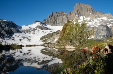
Our family trip in July had clear skies as we arrived at our first destination.

It is alway soul satisfying to be greeted by Mt Banner at Thousand Island Lake, even if it is overcast and stormy.
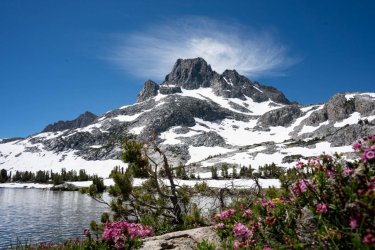
Russ in Mid August. Still tons of snow on the flanks of Banner.

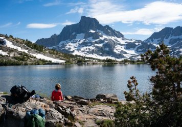
All of the campsites are dominated by the incredible scenery. Its easy to take a lot of pictures here.

A corner of the sky had some good color after sunset.

Full Moon making a digital asterisk before setting in the morning.

Campsite morning duties

For the August trip we had hoped to cross over a couple of passes into some new territory. Even with the availability of GPS, it is still good to keep the map and compass skills sharp.

The approach to the first snowy pass had a stream crossing in a beautiful meadow.

Looking back at some of the 1000 Islands.

Crossing the snow to the saddle of the pass.
There was too much snow at the next higher and steeper pass. We decided to curtail our cross country endeavors. We opted to hike down to Garnet lake for our next camp. Garnet lake offered a familiar, but different perspective from Thousand Island Lake.


Mark caught what looked like a hybrid Golden Rainbow trout that he released.

Mt. Ritter and Mt. Banner visible while hiking out of camp above Garnet Lake.

Interesting snow ledge for Russ to ponder.

We had to alter our return trail plans due to the conditions. I enjoyed my first visit to the Clarks Lakes as a detour.

The red rocks above our camp made for a great golden hour reflection.
Holly V.

Inquisitive marmot

From Clark Lakes we took the Highline trail back to the South, towards Mammoth. It was loaded with flowers.


Sierra Tiger Lilly

Summit Lake, a sheared wall of ice and our first view of some of the Minarets.


A giant mushroom near the trail.

Good view of the Minarets and Shadow Lake from the Highline trail.

There were a lot of White Lined Sphinx moths at altitude this summer.

Final couple of miles back to the parking area. Mammoth Mountain in view.
The passes were covered in snow long into the summer. I was glad we were able to do as much non technical traveling as we did. It was fun to see the spring changes by doing this trip twice in the space of 20 days.
Tim V.
From Southern California, it is always a good driving break to stop at the Alabama Hills. We spent some time finding a couple of new arches that we had not hiked to before.
Whitney Portal Arch.
Sunrise Cactus and Eye of Alabama Arch
New take on Mobius Arch
Valentine photo bombing Heart Arch
Puffy cloud photo bombing Heart arch
We picked up our permit in Mammoth and then did a day hike around Convict Lake.
One of the deepest Lakes in the Eastern Sierra. It was stormy.
A Rubber Boa was on the trail despite it being so cool out.
A lot of the trails we wanted to use were closed due to high water crossings. Most of the passes still had deep snow. As we hiked towards Thousand Island Lake on our first day there was noticeably fewer hikers on the PCT.
Middle Fork of the San Jaoquin River
Bend in the River
Sierra Garter snake
Trail flowers
There were large patches of snow on the upper part of the River trail even in late July.
Jean and Holly kicking up trail.
Our family trip in July had clear skies as we arrived at our first destination.
It is alway soul satisfying to be greeted by Mt Banner at Thousand Island Lake, even if it is overcast and stormy.
Russ in Mid August. Still tons of snow on the flanks of Banner.
All of the campsites are dominated by the incredible scenery. Its easy to take a lot of pictures here.
A corner of the sky had some good color after sunset.
Full Moon making a digital asterisk before setting in the morning.
Campsite morning duties
For the August trip we had hoped to cross over a couple of passes into some new territory. Even with the availability of GPS, it is still good to keep the map and compass skills sharp.
The approach to the first snowy pass had a stream crossing in a beautiful meadow.
Looking back at some of the 1000 Islands.
Crossing the snow to the saddle of the pass.
There was too much snow at the next higher and steeper pass. We decided to curtail our cross country endeavors. We opted to hike down to Garnet lake for our next camp. Garnet lake offered a familiar, but different perspective from Thousand Island Lake.
Mark caught what looked like a hybrid Golden Rainbow trout that he released.
Mt. Ritter and Mt. Banner visible while hiking out of camp above Garnet Lake.
Interesting snow ledge for Russ to ponder.
We had to alter our return trail plans due to the conditions. I enjoyed my first visit to the Clarks Lakes as a detour.
The red rocks above our camp made for a great golden hour reflection.
Holly V.
Inquisitive marmot
From Clark Lakes we took the Highline trail back to the South, towards Mammoth. It was loaded with flowers.
Sierra Tiger Lilly
Summit Lake, a sheared wall of ice and our first view of some of the Minarets.
A giant mushroom near the trail.
Good view of the Minarets and Shadow Lake from the Highline trail.
There were a lot of White Lined Sphinx moths at altitude this summer.
Final couple of miles back to the parking area. Mammoth Mountain in view.
The passes were covered in snow long into the summer. I was glad we were able to do as much non technical traveling as we did. It was fun to see the spring changes by doing this trip twice in the space of 20 days.
Tim V.
Attachments
Last edited:
")