Denali day hike question

Carlos

Member
Joined
Jan 24, 2014
Messages
86
Hi,

I am not able to find good information on some forums about day hiking in Denali, so let me try my luck here:

I will be in Denali next July for 4 days and I have a question about a planned day hike (I am taking the 6:30 am bus so I will have plenty of daylight for a long day hike). I am reading the Waits book and I want to spend one day in the Polychrome area and I need some feedback.

I think I can do Polychrome Ridge Walk 1 (2.5 miles) and then either hike at Polychrome Mountain East End (4 miles). Since I have only 4 days I was thinking of maybe making a day hike out of hiking up to Stony Dome and then go back east and then doing one Polychrome hike.

Any suggestions on should I spend the whole day in the Polychrome area (thinking that two hikes in the area will be different enough from each other, meaning the views) or combine it with Stony Dome and then figure out which hike in Polychrome is the best (the best, meaning views and potential wildlife viewing).
 
Thanks for the props, @Rockskipper BTW, my wife was going to send you some pix from her drive into the park last September but lost her data card. Anyway, she had a really great trip and passes along a huge thanks for giving her your pass.

Carlos, my first question is if you are interested in an overnighter in the Polychrome area?

I'll stick to the day hike ideas for now. It's easy to find great day hikes hikes anywhere in the park, but The Toklat area is my favorite. Keep in mind that It is really big country in the park and without trails, hiking is a little slower than normal. The glacial rivers are notorious hazards so be careful around them. Carry bear spray.

You could spend a few days in the Polychrome/Toklat area and not become bored. Rather than 2 shorter hikes, I'd commit to one longer one. I think once you are there, this will make more sense.

A ridge hike on Polychrome would be nice (but maybe crowded, by Alaska standards) and provides great views of that area of the park. I prefer hiking up or down the Toklat River with the opportunity to climb up on one of the ridges in the area. In the Stony Dome area, my preference is to head north down Stony Creek or Little Stony Creek and loop back up the other. Hiking up Stony Creek is also a great hike.

There will be Dall sheep and grizzlies anywhere you may go in the park, but the Toklat area, in my experience, offers the most consistent opportunities to see either species, even more consistent than Sable Pass. Also lots of wolf activity in the area. There used to be a den towards Highway Pass but I don't know if that is still active or not. This past August I saw 5 grizzlies from the Polychrome Pass Rest Stop, and plenty of grizzly & wolf sign along the Toklat River.

Another awesome day hike is Primrose Ridge. It's a good elevation gain to reach the ridge but once up there the hike is a cruise for the most part. If you are running short of time or energy, you can just bail off the ridge at nearly any point and return to the road within a couple hours.

Sorry for the jumbled answer but if you have any other questions, let me know. Hope that helps!
 
thanks for the info !!!! Let me digest this information and I will come back wit more questions. And, yes, I am doing day hikes only and I am careful with the bears (ran into some in the lower 48). I also figured out the 1 mile per hour kinda rule in Denali, so I am not being ambitious about long day hikes for miles and miles in the area.
 
I am taking a look at the Toklat river and there is this hike in the Waits book that starts at the Toklat river bridge and basically goes around Divide Mountain and crosses the Toklat river a couple of times. Another option that I have seen is get off the bus at the I Scream Gulch and just hike along the East branch of the Toklat until I decide to turn around. What your recommendation ?


Thanks for the props, @Rockskipper BTW, my wife was going to send you some pix from her drive into the park last September but lost her data card. Anyway, she had a really great trip and passes along a huge thanks for giving her your pass.

Carlos, my first question is if you are interested in an overnighter in the Polychrome area?

I'll stick to the day hike ideas for now. It's easy to find great day hikes hikes anywhere in the park, but The Toklat area is my favorite. Keep in mind that It is really big country in the park and without trails, hiking is a little slower than normal. The glacial rivers are notorious hazards so be careful around them. Carry bear spray.

You could spend a few days in the Polychrome/Toklat area and not become bored. Rather than 2 shorter hikes, I'd commit to one longer one. I think once you are there, this will make more sense.

A ridge hike on Polychrome would be nice (but maybe crowded, by Alaska standards) and provides great views of that area of the park. I prefer hiking up or down the Toklat River with the opportunity to climb up on one of the ridges in the area. In the Stony Dome area, my preference is to head north down Stony Creek or Little Stony Creek and loop back up the other. Hiking up Stony Creek is also a great hike.

There will be Dall sheep and grizzlies anywhere you may go in the park, but the Toklat area, in my experience, offers the most consistent opportunities to see either species, even more consistent than Sable Pass. Also lots of wolf activity in the area. There used to be a den towards Highway Pass but I don't know if that is still active or not. This past August I saw 5 grizzlies from the Polychrome Pass Rest Stop, and plenty of grizzly & wolf sign along the Toklat River.

Another awesome day hike is Primrose Ridge. It's a good elevation gain to reach the ridge but once up there the hike is a cruise for the most part. If you are running short of time or energy, you can just bail off the ridge at nearly any point and return to the road within a couple hours.

Sorry for the jumbled answer but if you have any other questions, let me know. Hope that helps!
 
Carlos, the East Fork hike is a good one. Of the 2 options (down- or up-stream, hiking up the East Fork will be a much better hike overall, even if you just hike back the same route.

Hiking around Divide Mountain would also be a great hike. As I previously mentioned, the big problem with glacial river/creek crossings is the dynamics of these systems. Low flow early in the day can still be un-crossable in the afternoon/evening. Just keep it in mind that you may have to backtrack rather than continue onward. By July, the snow melt should be done with, but if we have another sunny, warm summer, the glacial melt could limit crossings. Last August, crossing the main Toklat was impossible due to glacial melt as it was still raging.

Anyway, keep an open mind as to your final plans, until the conditions determine what can be done. You'll have a great time regardless.
 
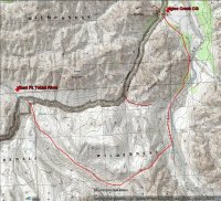
Carlos, another likely good option is to hike up the East Fork for 4-5 miles, take the pass east to the Teklanika River and head north (I have not done this yet), either cutting back to the road along the south of Cathedral Mountain (~11-12 miles), or if you have time, circumvent Cathedral Mountain to the east and return to the highway near Igloo Creek CG, ~15 miles.
 
Carlos, thought I would say a few things here myself. In the last five years have gone up in the summers to Alaska and have spent quite a
bit of time in Denali NP. The first time I was there for like 3 weeks. And the second time there near 2 weeks and loved it.

Now a couple of other hikes that will mention. One is the Savage River Area. from the park headquarters one can get a 'Free' bus up to the Savage River. There is a short hike here along the creek. But here also is a nice Savage Ridge Trail I will call it. It goes up to the top of the ridge nearby and back down to the road with coming out near the Savage River Campground. It is a good hike with some nice views. Now everytime I went on this hike up the ridge, i came upon some close encounters to some Dall Sheep. Once they were like only 10 feet nearby off the trail. Also in the Savage River Area I have seen some Grizzlies, a Wolf or two, and even once a Linx. And also I took long walks up the Savage River with splendid views.

In Denali, the bears can be anywhere so keep an eye out. Once saw a Black Bear right near the Visitor Center in the park headquarters area. It was only like 100 yards from the Visitor Center at the end of the day. So again the bears can be anywhere. Onetime on the bus in the park, saw near a dozen Grizzlies in a day.

Another dayhike which can be a good all day hike is the Triple Lakes Trail. It goes from or to ... McKinley Village to the Park Headquarters Area. It is a nice good trail and loved the scenery. I like hanging out for awhile near the Triple Lakes.

Now Outdoor Fool mentioned the wolves near the Toklat Area. When i was here would see some wolves in the area. Also Wonder Lake makes a good place to camp. If you want to camp here, then you will have to make your reservations here online early for it fills up quickly.

Now when I was here and going deep into the park, I made certain to get the first bus going out. The reason is do think they see more of the wildlife early in the morning then maybe some of the other buses. Just my opinion. Then would get here super early to get a prime seat at the front of the bus to view everything. Then when I would get to Eielson or wherever, would spend a majority of the rest of the day hiking about and would come back late in the day. Just four days in the park, hope you get some nice weather. Denali Park can be quite wet in the summer. Alaska itself can get quite wet in the summer. Both both the times I have been there, have seen Denali Peak under clear skies.

Just some brief thoughts. Hope you have an Excellent Trip.
 
Last edited:
oh wait, was I confused :( ............ I was looking at the map and couldnt figure out your route from the East Fork of the Toklat towards Cathedral Mountain for just 11 miles. And then I kept staring at the topo map and that damn river confused me. Let me see if now I am making sense: At the Toklat River bridge is where the West Fork of Toklat is (and close to Divide Mountain and WEST of the Polychrome mountains). The East Fork is EAST of the Polychrome Mountains and that is what I think is the route that you mention ( another likely good option is to hike up the East Fork for 4-5 miles, take the pass east to the Teklanika River and head north (I have not done this yet), either cutting back to the road along the south of Cathedral Mountain (~11-12 miles), or if you have time, circumvent Cathedral Mountain to the east and return to the highway near Igloo Creek CG, ~15 miles.), so I think is going south from the road on the Toklat River East Fork (I have no clue the direction of flow of the river until I guess I see it), find a route towards the Teklanika River and then go North to the road (or go around Cathedral Moin


Carlos, the East Fork hike is a good one. Of the 2 options (down- or up-stream, hiking up the East Fork will be a much better hike overall, even if you just hike back the same route.

Hiking around Divide Mountain would also be a great hike. As I previously mentioned, the big problem with glacial river/creek crossings is the dynamics of these systems. Low flow early in the day can still be un-crossable in the afternoon/evening. Just keep it in mind that you may have to backtrack rather than continue onward. By July, the snow melt should be done with, but if we have another sunny, warm summer, the glacial melt could limit crossings. Last August, crossing the main Toklat was impossible due to glacial melt as it was still raging.

Anyway, keep an open mind as to your final plans, until the conditions determine what can be done. You'll have a great time regardless.
 
oh wait, was I confused :( ............ I was looking at the map and couldnt figure out your route from the East Fork of the Toklat towards Cathedral Mountain for just 11 miles. And then I kept staring at the topo map and that damn river confused me. Let me see if now I am making sense: At the Toklat River bridge is where the West Fork of Toklat is (and close to Divide Mountain and WEST of the Polychrome mountains). The East Fork is EAST of the Polychrome Mountains and that is what I think is the route that you mention ( another likely good option is to hike up the East Fork for 4-5 miles, take the pass east to the Teklanika River and head north (I have not done this yet), either cutting back to the road along the south of Cathedral Mountain (~11-12 miles), or if you have time, circumvent Cathedral Mountain to the east and return to the highway near Igloo Creek CG, ~15 miles.), so I think is going south from the road on the Toklat River East Fork (I have no clue the direction of flow of the river until I guess I see it), find a route towards the Teklanika River and then go North to the road (or go around Cathedral Moin

Carlos, yes, the first bridge is the East Fork Toklat, the second bridge (west of Polychrome) is the Toklat River. The river flows north. I attached this map because a picture is worth it.

East_Fk_Toklat_to_Igloo_Creek.jpg
 
Similar threads
Thread starter Title Forum Replies Date
Outdoor_Fool October Denali Hike Hiking & Camping 21
kwc Album Denali Highway July 2023 Photography 3
kwc Savage River, Denali NP Hiking & Camping 1
TheMountainRabbit Upper Toklat River (Denali NP) - August 2018 Backpacking 7
Outdoor_Fool Denali NPP Moose Rut Hiking & Camping 6
C denali backpacking ideas Trip Planning 3
C denali backpacking Trip Planning 5
C denali Hiking & Camping 6
C hiking suggestions for Denali Trip Planning 6
kwc Alaska (again) Denali NP Hiking & Camping 7
Rockskipper Has anyone driven the Denali road to Wonder Lake in their own vehicle? General Discussion 11
Outdoor_Fool Quick Denali Trip Backpacking 6
Ben Denali NP, Teklanika and Sanctuary Rivers Backpacking 49
Nick Denali General Discussion 9
Q Alaska Denali park hiking Trip Planning 2
Ben Denali NP, Savage and Sanctuary Rivers Backpacking 10
Tres Westbrook Denali Fall Colors Everything Else 11
Curt Mt Healy Overlook Trail, Denali NP Backpacking 15
M Lost a drone in the San Rafael River area/below the wedge. No time to hike in to retrieve. General Discussion 0
TrailScot Day hike in the Upper East Side of Zion - October 2023 Hiking & Camping 5
TrailScot Upper Paria Loop Hike - September 2023 Backpacking 4
OldBill Short hike at the Grand Canyon of Pennsylvania Hiking & Camping 1
kwc Fall hike to Chase Lake, Southern Adirondacks Hiking & Camping 1
O YNP Union Falls easy hike Aug 4-8 2023? Meet Up (Members Only) 9
kwc Another Adirondack Hike Hiking & Camping 3
kwc Hadley Mountain hike Hiking & Camping 1
T America's Wildest Through-hike General Discussion 0
kwc Short Snowshoe Hike today, Southern Adirondacks Hiking & Camping 2
kwc Another Southern Adirondacks hike - Clockmill Pond and Rock Lake Hiking & Camping 0
Ellen What are your favorite spots to hike and camp in December? Trip Planning 10
F The El Camino Real, A failed hike. Backpacking 16
P Scatman's Grizzly Lake hike, 2022 Backpacking 28
Jackson Quick day hike in the Montana Absarokas Hiking & Camping 13
kwc Adirondack Hike to Middle Lake Hiking & Camping 0
TrailScot "I'll take the High Road ..." - A Loop Hike around the Canyons of Needles - May 2022 Trip Reports 14
norwegianxplorer Hiking Sierra de las Nieves, Spain. Sunrise hike from Yunquera, Andalusia, Wild boar and Spanish Ibex Hiking & Camping 0
Rockskipper Afraid to hike alone? Go with this guy - or maybe not. General Discussion 2
Titans Birthday hike Nov 2021 Hiking & Camping 13
P A short hike on the AT in Shenandoah National Park Hiking & Camping 0
kwc Hadley Mountain Fire Tower hike, Southern Adirondacks Hiking & Camping 1
seekinglost 1000 Mile Nevada Thru Hike on the Basin and Range Trail Trip Reports 14
kwc Short hike to a fire tower Hiking & Camping 3
MikeP Canmore Thru-Hike Trip Planning 1
JuddOutdoors Hike To Grass Lake //Desolation Wilderness //Lake Tahoe Basin Hiking & Camping 0
kwc Blue Mountain hike, Central Adirondacks Hiking & Camping 0
kwc Goodnow Mountain fire tower hike Hiking & Camping 2
norwegianxplorer Mt Whitney Virtual Hike via Horseshoe Meadows & Mt Langley, Sequoia Kings Canyon National Park Backpacking 1
kwc Winter Hike into Broomstick Lake 1/13/21 Hiking & Camping 2
Tomaswmitchell Cuberant Lake hike, Bigfoot tracks? Video Hiking & Camping 2
kwc Stony Pond hike, Central Adirondacks Hiking & Camping 1

Similar threads

Back
Top