- Joined
- Jan 4, 2015
- Messages
- 2,908
It pays to be prepared. On a random Thursday night in late June 2016, I decided to go on a spur-of-the-moment backpacking trip over the weekend. Thankfully I have enough route creations rattling around in my Caltopo account that it's easy to print one and go on a moment's notice. This one was the Delano Peak Loop, something that had been collecting dust for a couple years.
I'd never been to the Tushars - and boy I was in for a treat. I drove down Friday after work to the Big Flat area south of the high peaks and the ski resort in the range. I parked my car and hiked a mile in. I threw my sleeping bag on the ground and slept under a brilliant starry sky. I have a simple camera phone and am always too sleepy to take star photos, so you'll have to trust me.

I woke up the next morning and hit the trail. The trail dipped and weaved northward, generally following the ridgeline, occasionally flirting with the edge of treeline. I caught occasional glimpses of the high country that lay ahead of me.

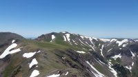
I left the trail and followed a ridgeline, ascending to a shoulder southwest of Mt Holly, the southernmost of the "big" peaks of the Tushars. When I arrived, my jaw dropped. The views were amazing. A huge subalpine basin lay in front of me, and on a distant ridge, I spotted a herd of mountain goats doing their thing. Wildlife would be a common sight on this hike.


I had demurred on this hike years for several reasons, a major one being the state of trails - a big unknown. There was a trail crossing this basin - somewhere. I wasn't sure whether it existed or whether it had seen any maintenance recently. As it turns out, the trail faded in and out of existence. Most of it was sketchy or nonexistent. But the views were beautiful and the day was picture-perfect.

After a few hours, I reached a dirt road which led to a saddle on a major east-west ridge. I called an audible and decided to hike the ridge directly west toward Delano Peak (the highest peak in the range) rather than dropping down into a canyon and climbing back out of it. The ridge was steep in a couple spots but generally straightforward - and oh my goodness - the view!


After an hour or so on the ridge, I spotted Delano Peak. Wildflowers dotted the high ridgelines. Patches of snow hung on for dear life in the intense sunshine - I like to think of them as "The Little Glaciers That Could".

Soon enough, there was no more up. Delano Peak, 12,000+ feet. Highest in the Tushars, highest in Utah outside of the Uintas and the La Sals. Photos don't do justice to the panoramas. To the north, even more rugged peaks beckoned.


I lingered for a while on the summit ridge, heading north as I gradually lost elevation. By this point, my stomach was talking to me about the fact that it hadn't eaten quite enough lunch. I stopped by the inspiringly-named Mud Lake for some supper.

Walking a 4WD road, I soon encountered a family from Beaver on ATV's. They seemed curious about what I was doing and were genuinely surprised to see a hiker. I guess not too many folks visit the Tushars! I stopped again and a random trailhead/picnic table for Supper 2.0. I hiked a couple miles, now on a marked and maintained trail, and threw my sleeping bag on the ground after a long but amazing day. Just days after the summer solstice, the sun lingered in the sky, unwilling to go to bed just yet.

The birds were up early, as was I. I followed the trail at the edge of treeline, ducking in and out of drainages as I paralleled the main crest of the range beneath Delano Peak and Mt Holly.


I made a quick stop to summit Lake Peak, from which I could see almost my entire route. I enjoyed views of Puffer Lake to the west. Oh, and I enjoyed an almost obscene number of gummy bears. Mmmmmmm, gummy bears.

After another half mile, I rejoined the trail I had hiked yesterday along the forested ridgeline, south to my car. I was driving back to Salt Lake by noon. A short adventure, but an adventure nonetheless. And I'll be back, to check out those rugged peaks to the north. A successful weekend.
Click here to view on CalTopo
I'd never been to the Tushars - and boy I was in for a treat. I drove down Friday after work to the Big Flat area south of the high peaks and the ski resort in the range. I parked my car and hiked a mile in. I threw my sleeping bag on the ground and slept under a brilliant starry sky. I have a simple camera phone and am always too sleepy to take star photos, so you'll have to trust me.
I woke up the next morning and hit the trail. The trail dipped and weaved northward, generally following the ridgeline, occasionally flirting with the edge of treeline. I caught occasional glimpses of the high country that lay ahead of me.
I left the trail and followed a ridgeline, ascending to a shoulder southwest of Mt Holly, the southernmost of the "big" peaks of the Tushars. When I arrived, my jaw dropped. The views were amazing. A huge subalpine basin lay in front of me, and on a distant ridge, I spotted a herd of mountain goats doing their thing. Wildlife would be a common sight on this hike.
I had demurred on this hike years for several reasons, a major one being the state of trails - a big unknown. There was a trail crossing this basin - somewhere. I wasn't sure whether it existed or whether it had seen any maintenance recently. As it turns out, the trail faded in and out of existence. Most of it was sketchy or nonexistent. But the views were beautiful and the day was picture-perfect.
After a few hours, I reached a dirt road which led to a saddle on a major east-west ridge. I called an audible and decided to hike the ridge directly west toward Delano Peak (the highest peak in the range) rather than dropping down into a canyon and climbing back out of it. The ridge was steep in a couple spots but generally straightforward - and oh my goodness - the view!
After an hour or so on the ridge, I spotted Delano Peak. Wildflowers dotted the high ridgelines. Patches of snow hung on for dear life in the intense sunshine - I like to think of them as "The Little Glaciers That Could".
Soon enough, there was no more up. Delano Peak, 12,000+ feet. Highest in the Tushars, highest in Utah outside of the Uintas and the La Sals. Photos don't do justice to the panoramas. To the north, even more rugged peaks beckoned.
I lingered for a while on the summit ridge, heading north as I gradually lost elevation. By this point, my stomach was talking to me about the fact that it hadn't eaten quite enough lunch. I stopped by the inspiringly-named Mud Lake for some supper.
Walking a 4WD road, I soon encountered a family from Beaver on ATV's. They seemed curious about what I was doing and were genuinely surprised to see a hiker. I guess not too many folks visit the Tushars! I stopped again and a random trailhead/picnic table for Supper 2.0. I hiked a couple miles, now on a marked and maintained trail, and threw my sleeping bag on the ground after a long but amazing day. Just days after the summer solstice, the sun lingered in the sky, unwilling to go to bed just yet.
The birds were up early, as was I. I followed the trail at the edge of treeline, ducking in and out of drainages as I paralleled the main crest of the range beneath Delano Peak and Mt Holly.
I made a quick stop to summit Lake Peak, from which I could see almost my entire route. I enjoyed views of Puffer Lake to the west. Oh, and I enjoyed an almost obscene number of gummy bears. Mmmmmmm, gummy bears.
After another half mile, I rejoined the trail I had hiked yesterday along the forested ridgeline, south to my car. I was driving back to Salt Lake by noon. A short adventure, but an adventure nonetheless. And I'll be back, to check out those rugged peaks to the north. A successful weekend.
Click here to view on CalTopo
")
