Death Hollow Loop in mid-September

Joined
Jun 3, 2016
Messages
6
Hi all,

I've gathered from searches that this is a popular topic here, so apologies for bringing it up yet again, but I have a few specific questions I haven't seen addressed.

Details: A friend and I are planning to do a 3-day clockwise loop next week starting in Escalante, hiking north on the Boulder Mail Trail, down through Death Hollow, and then back to Escalante along the river (essentially this itinerary: https://www.outdoorproject.com/united-states/utah/death-hollow-backpacking-loop). We're both experienced backpackers who have been on several trips in GSENM, but we'll be flying in from elsewhere and I just want to make sure I'm not overlooking something while we still have time to change plans.

Questions:

1) It seems like the vast majority of information, including on here, is about the route from Boulder to Hwy 12. Why is that? In my experience, loops tend to be more popular where possible, so I'm a little confused that so many people seem to do that route and comparatively few do the loop we're planning to do.

2) Anything specific we need to know about this time of year? In particular, anything water-related would be helpful. It looks like the Escalante is really low, but from what I've read I'm assuming Death Hollow will definitely have water? And I'm guessing we should assume Mamie Creek will be dry on our way in? Right now the forecast is calling for showers during the first day of our trip (Wednesday), should we be concerned about that?

3) Not really a question, but if anyone has suggestions for places to camp near Escalante the night before, I'd love to hear them. I'm a photographer, so I'm especially interested in any particularly scenic camping spots not too far from the trailhead.

Thanks for your help!
 
Hey MOY-I have done this loop and while it is enjoyable it is my least favorite route into death hollow, from the Death Hollow confluence back to Escalante the Escalante river can be hit and miss this late into summer as far as quantity (if any) and quality of water. Death Hollow will have good water. If your coming from the North I would camp on the Boulder Mountain somewhere off Hwy 12 the views into the desert are awesome and if your coming in late Sept.-early Oct. the quakies will be blazing!
 
Last edited:
Thanks for the info! I kind of assumed there might not be much water in the river based on the current flow rate and another trip report I saw, but my thought was we could fill up when leaving Death Hollow and carry what we need for the last day (which I think should be the easiest day?). We've already done the stretch between Hwy 12 and Sand Creek on a previous trip, so I'm curious to see a different stretch of the river. I'll check out Boulder Mountain for the first night...we'll be coming down from SLC.
 
Always water in DH and the Escalsnte.
 
Always water in DH and the Escalsnte.
Second that... both Death Hollow and the Escalante river always have water flowing. They are both perennial streams. The water quality in Death Hollow's water course is typically much better but the Escalante is always drinkable too (after filtering or magic wanding of course - there is plenty of cattle and other sources polluting it).
 
I have been through this section (Escalante town to the Death Hollow confluence) many times in late summer where there has been no water. In 2017 me and my kids spent 6-7 hours under some shade trees waiting until evening to exit due to heat and lack of water.
 
It's not that far from DH to Escalsnte TH.... Pack it from DH.... The times I've been thru there in late aug. Always fround water in hokes..
 
(essentially this itinerary: https://www.outdoorproject.com/united-states/utah/death-hollow-backpacking-loop).

I just completed this loop alone yesterday. I’m from the PNW and am relatively new to canyons and the Death Hollow section had one or two spots in the narrows that pushed my limits of comfort. The water level in DH is low enough (still plenty of water) that I never got wet past my upper thighs (I’m 6’1”). I was committed to not swimming or getting in too deep, otherwise even the sketchy moments would have been fine. At first I assumed the ‘narrow ledge’ in that route’s description referred to something up high and dry, but that proved to be a dangerous dead-end. The ‘ledge’ I ended up using was partially submerged and slippery, and I utilized handholds in the sandstone while crouching under a low overhang to get past the deeper pools more or less dry above the knees. It was dicey.

Also, there are very large, very tall and healthy-looking patches of poison ivy along the entire DH section. Keep your eyes open! I wore long sleeves and seem to have escaped unscathed, but there were times I just raised my hands above my head and ‘waded’ through poison ivy up to my chest. Unsettling. Most of the time you can avoid those patches by staying in the water, but there were a couple times I went through them.

Questions:

1) It seems like the vast majority of information, including on here, is about the route from Boulder to Hwy 12. Why is that? In my experience, loops tend to be more popular where possible, so I'm a little confused that so many people seem to do that route and comparatively few do the loop we're planning to do.


I agree, loops are the best! I saw two people total from the trailhead until reaching the Escalante River. I enjoyed the solitude, especially on a not-too-hot Saturday when I have to assume lots of people were out in GESNM. I probably saw 9-10 folks along the Escalante River section.

2) Anything specific we need to know about this time of year? In particular, anything water-related would be helpful. It looks like the Escalante is really low,

At the confluence with DH, the ‘river’ looked almost stagnant and scuzzy so I filled up an extra bottle from DH. About a mile upstream it was completely dry, but in another ½ mile or so, a strong flow returned and continued all the way to the trailhead. I don’t know how quickly that can change, but I’d be very surprised if it was dry next week. At minimum I’d expect regular pools.

You’ll have a chance to assess the ER flow at the beginning of your loop: before leaving the river at the BMT junction, take a minute to hike down to the river and look at the water level. Should be a pretty good indicator of what you can expect on your final leg.

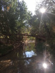
Here’s a photo of the Escalante River a few miles away from the trailhead:
B60E02CA-69AA-45C9-A5E3-864BD42DBB93.jpeg

but from what I've read I'm assuming Death Hollow will definitely have water?

Yes, lots.

And I'm guessing we should assume Mamie Creek will be dry on our way in?

Where the BMT crosses, Mamie wasn’t flowing but there were large pools. Depending on your treatment method(s) I think you’ll be able to find water if you look a little up and down stream when you cross. Expect the quality to be less than a flowing creek, but I’m of the opinion that any water in a desert is good water.

There were actually large pools along a more seasonal (un-named?) stream bed as you cross Antone Flats a couple miles before Mamie (assuming you go clockwise as per the route description you referenced). I’d bet there will still be water in some of them.

It was a fantastic loop, providing several different experiences in a compact route. Enjoy!
 
Last edited:
In the top of Mamie in the box canyon is a large pouroff pool. Holds fish so should be there year round.

If you really want an extreme I retesting trip with lots of swims start at the very top.....
 
Similar threads
Thread starter Title Forum Replies Date
Duketogo13 BMT- Death Hollow-Escalante Triangle loop Trip Planning 20
norwegianxplorer Death Hollow from Hells Backbone road 7 day loop with My Own Frontier Canyoneering 0
M Escalante- Little Death Hollow Loop conditions? Trip Planning 14
George_Washington_Hayduke Grand Staircase Escalante National Monument: Little Death Hollow/Horse/Wolverine Loop Backpacking 0
slc_dan Little Death Hollow-Wolverine Loop, GSENM June 5-8 2013 Backpacking 16
Nick Little Death Hollow & Wolverine Loop Backpacking 38
F Little Death Hollow Backpack Trip Planning 2
climbhigh1119 How doable is the sneak route out of Death Hollow with kids and a dog? Trip Planning 6
Janice Cosmic Ashtray via Wolverine/Little Death Hollow & Escalante River? Trip Planning 16
Bob Death Hollow - Top Half a revist..... Backpacking 0
RyanP Conditions (water/bugs) for Escalante/Death Hollow Trip Planning 27
J Trip first week of April 2021 Southern UT/Anywhere AZ - Death Hollow, Coyote Gulch, or other suggestions? Trip Planning 9
R Boulder Mail Trail to Death Hollow Trip Planning 1
Mikjik86 Flooded out in Death Hollow, Utah. May - 2019 Backpacking 4
RyanP Lower Death Hollow next week (late May/early June), miscellaneous questions Trip Planning 16
piper01 Little Death Hollow, GSENM Hiking & Camping 3
Boognish Lower Death Hollow Narrows April 2018 Backpacking 17
N Noob from CLE, headed to Death Hollow Noobs: Introduce yourself! 12
Kullaberg63 Upper Death Hollow - blitz descent Backpacking 8
Kullaberg63 Death Hollow 6-21 to 6-24 Meet Up (Members Only) 0
Strawsome Lower Death Hollow at it's finest Backpacking 3
J Escalante Natl Mon. Wolverine and Little Death Hollow and overland routes April 22-25, 2018 Backpacking 0
RyanP Lower Death Hollow, mid-April Trip Planning 8
dhertbag Looking for info on Death Hollow Trip Planning 13
Devin Ashby Upper Escalante Canyon / Death Hollow Info? Trip Planning 15
Jackson Death Hollow from the Boulder Mail Trail Backpacking 18
Skiwi Boulder Mail Trail to Death Hollow questions Trip Planning 8
muir_mountain Death Hollow (2 nights), Escalante National Monument, UT Backpacking 5
DiscGo Confessions of Stupidity: Little Death Hollow Hiking & Camping 6
K Poison Ivy Levels in Death Hollow Trip Planning 5
Kyle P Death Hollow in Early May Backpacking 4
K Question on Death Hollow Approaches Trip Planning 9
J Death Hollow Trip Planning 6
Joey Upper Death Hollow and the Old Bowington Road, From Hell's Backbone down to the Escalante River Backpacking 24
Kyle P Death Hollow In the Spring Trip Planning 22
A Anyone been to Death hollow/ escalante recently? Trip Planning 2
BJett Part 2. BMT - Death Hollow - Escalante River Backpacking 14
BJett Part 1. BMT - Death Hollow - Escalante River Backpacking 9
J Will be in Death Hollow in 2 weeks, had a question...... Trip Planning 28
Bob Death Hollow - From Hells Backbone Road to the BMT Backpacking 14
bscuderi Escalante Death Hollow Backpacking 11
Bob Death Hollow .... some pics Backpacking 4
BJett Death Hollow/Bowington Road Trip Planning 7
J Back again, looking for different access points for Death Hollow...... Trip Planning 9
J History Teacher here planning a backpacking trip for my students to Death Hollow...... Trip Planning 14
J Anyone been through Death Hollow recently? Trip Planning 25
J Planning to do Death Hollow for the 2.5 time.... Trip Planning 12
Nick Death Hollow Trip Planning 0
Nick Death in Birch Hollow General Discussion 0
J Apologize, but asking for more Death Hollow tips.... Trip Planning 23

Similar threads

Back
Top