- Joined
- Aug 21, 2018
- Messages
- 677
Last week @Bob stated that I needed to incorporate more roots, rocks, and mud into my training if I was going to survive the Thorofare.
Mud was sparse on today's hike, but I was able to check roots and rocks off the list. . . hopefully to Bob's satisfaction.
Mrs. TractorDoc joined me today for an early drive to Cuyahoga Valley. We tackled the out and back hike to Blue Hen Falls first. I posted about this short hike in previous report, so I'll skim over the details this time around.
The mile and a half hike to the falls follows some undulating terrain. Going up!
![0O7A0287[1].JPG 0O7A0287[1].JPG](https://backcountrypost.com/data/attachments/123/123230-9832781a048ef648d2a44202f0db107c.jpg)
When we arrived at the falls we had it all to ourselves. We knew it would not be long before others arrived though as we had passed several groups on the trail.
I had enough time to set the camera up for our picture. Still testing the range on the remote; it worked about half the time I wanted it to.
![0O7A0295[1].JPG 0O7A0295[1].JPG](https://backcountrypost.com/data/attachments/123/123231-310998725e990edad7c0c973d6eedf8f.jpg)
We wandered downstream a bit. Technically there was some mud encountered here, but not likely to Bob's standards.
![0O7A0304[1].JPG 0O7A0304[1].JPG](https://backcountrypost.com/data/attachments/123/123232-6b38c8a06291f361d92d5112cd789024.jpg)
Some scrambling on the way out. Roots -- check. Rocks -- check.
![0O7A0307[1].JPG 0O7A0307[1].JPG](https://backcountrypost.com/data/attachments/123/123233-5c59341d5890361a0953156abd347ab2.jpg)
Waterfall pictures before the party started.
![0O7A0309[1].JPG 0O7A0309[1].JPG](https://backcountrypost.com/data/attachments/123/123234-73f9725641bbdeda6bbd79b63ed7a7e9.jpg)
![0O7A0312[1].JPG 0O7A0312[1].JPG](https://backcountrypost.com/data/attachments/123/123235-76f81ccef5a4ed52e59978a6f63283b0.jpg)
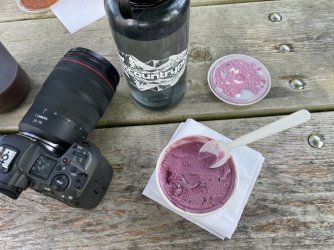
A quick ice cream break. . .
Then it was off to an area called The Ledges. I would describe the ledges as a big chunk of exposed sandstone with a trail around the perimeter as well as across the top. This trail sign probably tells a better story.
![0O7A0367[1].JPG 0O7A0367[1].JPG](https://backcountrypost.com/data/attachments/123/123236-d4852982876b0446c99d837c9ada9efa.jpg)
We started out from the Octagon Trailhead and worked our way up to the trail.
![0O7A0322[1].JPG 0O7A0322[1].JPG](https://backcountrypost.com/data/attachments/123/123238-7a5d67f78a563a973413ff42a58ba3f6.jpg)
![0O7A0324[1].JPG 0O7A0324[1].JPG](https://backcountrypost.com/data/attachments/123/123239-11d9becc613f0851180f79d80ce3ab2c.jpg)
The trail was a good choice for anyone looking to incorporate roots and rocks into their hike.
![0O7A0331[1].JPG 0O7A0331[1].JPG](https://backcountrypost.com/data/attachments/123/123241-ed1f543918ea8ab0f19c223fa3ea3028.jpg)
Many pictures that follow are looking up at rock formations from different points along the trail.
Mrs TD said this one looked like a monkey face. I did not notice that at first, but now that I see it I cannot unsee it.
![0O7A0327[1].JPG 0O7A0327[1].JPG](https://backcountrypost.com/data/attachments/123/123240-5a3d58fd6847f458f0be30a9545dc76b.jpg)
![0O7A0337[1].JPG 0O7A0337[1].JPG](https://backcountrypost.com/data/attachments/123/123242-576e5bf01bda973aaf9b8d4e00d9c187.jpg)
![0O7A0350[1].JPG 0O7A0350[1].JPG](https://backcountrypost.com/data/attachments/123/123243-c55879896ccf2128ae9b92a2f83f5f6b.jpg)
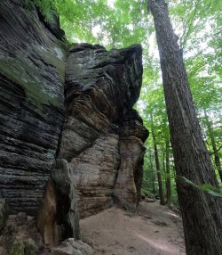
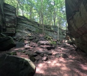
Somewhere along the way I was pointing out some of the differences/transitions in geology to Mrs. TD, but here it seems I was not able to hold her interest.
![0O7A0353[1].JPG 0O7A0353[1].JPG](https://backcountrypost.com/data/attachments/123/123244-4996c18b3e726c5a5479c11a23706a34.jpg)
Ice Box Cave is fenced off to keep people out. Nearby postings mention that an endangered bat lives in the cave.
![0O7A0354[1].JPG 0O7A0354[1].JPG](https://backcountrypost.com/data/attachments/123/123245-d2d3a40c8239cd60e1aca9a2cc224f3b.jpg)
![0O7A0359[1].JPG 0O7A0359[1].JPG](https://backcountrypost.com/data/attachments/123/123246-96b2196b24428cc4dd570a959f84010b.jpg)
Staircase built by the CCC back in the day. Where do those stairs go? They go up, of course!
![0O7A0366[1].JPG 0O7A0366[1].JPG](https://backcountrypost.com/data/attachments/123/123247-5a9309236858df0241acd3dc2f629219.jpg)
After circling the ledges we took a quick walk up the towpath trail thru the Beaver Swamp.
Highlights included some flowers. Milkweed and Rose of Sharon?
![0O7A0380[1].JPG 0O7A0380[1].JPG](https://backcountrypost.com/data/attachments/123/123250-24e75fed62516654de6afd4370b5eef0.jpg)
![0O7A0381[1].JPG 0O7A0381[1].JPG](https://backcountrypost.com/data/attachments/123/123251-61d0376b63b0c8ef093513930975cd7a.jpg)
Possibly my favorite photo of the day. . .
![0O7A0379[1].JPG 0O7A0379[1].JPG](https://backcountrypost.com/data/attachments/123/123249-4a0388e901f86c80396078852222034c.jpg)
There was some wildlife too.
![0O7A0385[1].JPG 0O7A0385[1].JPG](https://backcountrypost.com/data/attachments/123/123252-f5b3e097d962961f76bcfaa63e64f2bf.jpg)
![0O7A0387[1].JPG 0O7A0387[1].JPG](https://backcountrypost.com/data/attachments/123/123253-3b99cba5e145ded3801f054af7e1c8e3.jpg)
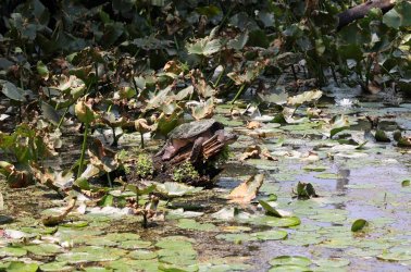
At first I thought Hugh would be happy with the previous snapper shot, but then I saw this next one flopped out on a log. My focus is not as crisp as it could be, but that turtle had the @scatman smile mastered.
![0O7A0369[1].JPG 0O7A0369[1].JPG](https://backcountrypost.com/data/attachments/123/123248-3fbccf08f4c85ba6f0e5c759174525f5.jpg)
A stop at Ohio Pie on the way home -- this time I tried their Piggy Bird Pizza.

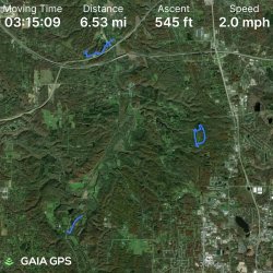
GAIA GPS snapshot. Not the biggest mileage day, but it was more about the ups and downs today than it was the distance.
The End!
Mud was sparse on today's hike, but I was able to check roots and rocks off the list. . . hopefully to Bob's satisfaction.
Mrs. TractorDoc joined me today for an early drive to Cuyahoga Valley. We tackled the out and back hike to Blue Hen Falls first. I posted about this short hike in previous report, so I'll skim over the details this time around.
The mile and a half hike to the falls follows some undulating terrain. Going up!
![0O7A0287[1].JPG 0O7A0287[1].JPG](https://backcountrypost.com/data/attachments/123/123230-9832781a048ef648d2a44202f0db107c.jpg)
When we arrived at the falls we had it all to ourselves. We knew it would not be long before others arrived though as we had passed several groups on the trail.
I had enough time to set the camera up for our picture. Still testing the range on the remote; it worked about half the time I wanted it to.
![0O7A0295[1].JPG 0O7A0295[1].JPG](https://backcountrypost.com/data/attachments/123/123231-310998725e990edad7c0c973d6eedf8f.jpg)
We wandered downstream a bit. Technically there was some mud encountered here, but not likely to Bob's standards.
![0O7A0304[1].JPG 0O7A0304[1].JPG](https://backcountrypost.com/data/attachments/123/123232-6b38c8a06291f361d92d5112cd789024.jpg)
Some scrambling on the way out. Roots -- check. Rocks -- check.
![0O7A0307[1].JPG 0O7A0307[1].JPG](https://backcountrypost.com/data/attachments/123/123233-5c59341d5890361a0953156abd347ab2.jpg)
Waterfall pictures before the party started.
![0O7A0309[1].JPG 0O7A0309[1].JPG](https://backcountrypost.com/data/attachments/123/123234-73f9725641bbdeda6bbd79b63ed7a7e9.jpg)
![0O7A0312[1].JPG 0O7A0312[1].JPG](https://backcountrypost.com/data/attachments/123/123235-76f81ccef5a4ed52e59978a6f63283b0.jpg)
A quick ice cream break. . .

Then it was off to an area called The Ledges. I would describe the ledges as a big chunk of exposed sandstone with a trail around the perimeter as well as across the top. This trail sign probably tells a better story.
![0O7A0367[1].JPG 0O7A0367[1].JPG](https://backcountrypost.com/data/attachments/123/123236-d4852982876b0446c99d837c9ada9efa.jpg)
We started out from the Octagon Trailhead and worked our way up to the trail.
![0O7A0322[1].JPG 0O7A0322[1].JPG](https://backcountrypost.com/data/attachments/123/123238-7a5d67f78a563a973413ff42a58ba3f6.jpg)
![0O7A0324[1].JPG 0O7A0324[1].JPG](https://backcountrypost.com/data/attachments/123/123239-11d9becc613f0851180f79d80ce3ab2c.jpg)
The trail was a good choice for anyone looking to incorporate roots and rocks into their hike.
![0O7A0331[1].JPG 0O7A0331[1].JPG](https://backcountrypost.com/data/attachments/123/123241-ed1f543918ea8ab0f19c223fa3ea3028.jpg)
Many pictures that follow are looking up at rock formations from different points along the trail.
Mrs TD said this one looked like a monkey face. I did not notice that at first, but now that I see it I cannot unsee it.
![0O7A0327[1].JPG 0O7A0327[1].JPG](https://backcountrypost.com/data/attachments/123/123240-5a3d58fd6847f458f0be30a9545dc76b.jpg)
![0O7A0337[1].JPG 0O7A0337[1].JPG](https://backcountrypost.com/data/attachments/123/123242-576e5bf01bda973aaf9b8d4e00d9c187.jpg)
![0O7A0350[1].JPG 0O7A0350[1].JPG](https://backcountrypost.com/data/attachments/123/123243-c55879896ccf2128ae9b92a2f83f5f6b.jpg)


Somewhere along the way I was pointing out some of the differences/transitions in geology to Mrs. TD, but here it seems I was not able to hold her interest.
![0O7A0353[1].JPG 0O7A0353[1].JPG](https://backcountrypost.com/data/attachments/123/123244-4996c18b3e726c5a5479c11a23706a34.jpg)
Ice Box Cave is fenced off to keep people out. Nearby postings mention that an endangered bat lives in the cave.
![0O7A0354[1].JPG 0O7A0354[1].JPG](https://backcountrypost.com/data/attachments/123/123245-d2d3a40c8239cd60e1aca9a2cc224f3b.jpg)
![0O7A0359[1].JPG 0O7A0359[1].JPG](https://backcountrypost.com/data/attachments/123/123246-96b2196b24428cc4dd570a959f84010b.jpg)
Staircase built by the CCC back in the day. Where do those stairs go?
![0O7A0366[1].JPG 0O7A0366[1].JPG](https://backcountrypost.com/data/attachments/123/123247-5a9309236858df0241acd3dc2f629219.jpg)
After circling the ledges we took a quick walk up the towpath trail thru the Beaver Swamp.
Highlights included some flowers. Milkweed and Rose of Sharon?
![0O7A0380[1].JPG 0O7A0380[1].JPG](https://backcountrypost.com/data/attachments/123/123250-24e75fed62516654de6afd4370b5eef0.jpg)
![0O7A0381[1].JPG 0O7A0381[1].JPG](https://backcountrypost.com/data/attachments/123/123251-61d0376b63b0c8ef093513930975cd7a.jpg)
Possibly my favorite photo of the day. . .
![0O7A0379[1].JPG 0O7A0379[1].JPG](https://backcountrypost.com/data/attachments/123/123249-4a0388e901f86c80396078852222034c.jpg)
There was some wildlife too.
![0O7A0385[1].JPG 0O7A0385[1].JPG](https://backcountrypost.com/data/attachments/123/123252-f5b3e097d962961f76bcfaa63e64f2bf.jpg)
![0O7A0387[1].JPG 0O7A0387[1].JPG](https://backcountrypost.com/data/attachments/123/123253-3b99cba5e145ded3801f054af7e1c8e3.jpg)
At first I thought Hugh would be happy with the previous snapper shot, but then I saw this next one flopped out on a log. My focus is not as crisp as it could be, but that turtle had the @scatman smile mastered.

![0O7A0369[1].JPG 0O7A0369[1].JPG](https://backcountrypost.com/data/attachments/123/123248-3fbccf08f4c85ba6f0e5c759174525f5.jpg)
A stop at Ohio Pie on the way home -- this time I tried their Piggy Bird Pizza.

GAIA GPS snapshot. Not the biggest mileage day, but it was more about the ups and downs today than it was the distance.

The End!
