Connecting trails between Younts/Thorofare

futurafree

Member
Joined
Apr 1, 2021
Messages
180
Connecting these two trails via off-trail between the peaks... has anyone been through here in the somewhat recent past? I feel like I heard there was a game or use trail that might get a bit sketchy/spicy in short sections, and wondered if it was better now or if it had eroded away or if it even ever existed.
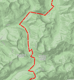
Screenshot 2025-05-30 163335.png
 
I wonder where you might have heard about that trail? :)

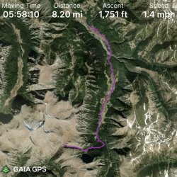
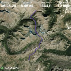
Some GPS tracks from the Scatman/Bob/Scott/Dave trip across that area in 2023. I believe we sent @Georgia Yankee up that route last year after he left us in Hidden Creek.

Don't follow the first track exactly -- avoid the backwards "C" and keep to the West to head up Majo Pass.

GPS Track Day 6.jpg GPS Track Day 7.jpg
 
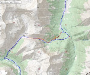
Here is our route in blue. I believe the actual trail follows the reddish line. The red dots in a row are the projected trail.

aaa majo.jpg
 
Here is our route in blue. I believe the actual trail follows the reddish line. The red dots in a row are the projected trail.
Much appreciated, Bob. I'm looking forward to getting out there again. I found the old trip report with you guys and saw there was still the perfect amount of snow patches for running creeks everywhere in early/mid-August. I'll probably be there a week or two later.
 
I've been through there twice, most recently in on July 20, 2020. The first trip was less successful in finding the route, the second was more successful. Here's what I learned, going off memory of course, because the critical waypoint that I took vamoosed into the depths of electronic lala land:

As you descend that little pass thing toward the Thorofare, stay skier's left (N) of the drainage on the faint outfitters/elk trail. As you mentioned, the footing will be a bit sketchy at times. If you can follow it, do (at least as long as you can safely). Otherwise, cut down toward the bottom of the drainage, but try and stay slightly above the drainage if you can. If you go all the way into the bottom, it'll be fine at first but eventually dump you into a sea of thick brush, ergo much suffering. So stay a bit above the drainage especially as it begins to fan out and you should pick the trail back up. That should, in my recollection, dump you onto the actual designated Thorofare trail eventually.

How's that for dodgy internet beta? :)

Edit: Just found something I wrote back then, when my memory was fresher:

Once you crest the pass, the outfitter trail will hug the north wall of the drainage that leads down into Thorofare Creek. At one point, I got too sketched out by this trail and dropped down to the bottom of the gully... I then picked up up again a few tenths farther E. As you get more and more enveloped by trees, you'll DEFINITELY want to find that use trail again (still on the N side of the stream), as it's an absolutely miserable thrash if you don't.
 
Last edited:
Here is our route in blue. I believe the actual trail follows the reddish line. The red dots in a row are the projected trail.

View attachment 141960The orange line is my track. Coming up from the east you can see where I turned to the NE then doubled back. Well, that is where I found the very well maintained outfitter trail. I followed it a little to the NE to see where it was coming from then followed it the rest of the way to the pass. Going east to west I found the upper trail to be very steep but not unreasonable. I would not want to do that part W to E. If you are trying to catch the trail from Thorofare Ck. you need to start climbing up much sooner than you probably think you should.
 
Thanks! I was so confused that I didn't realize how close I was to that area I've thought about going through for a long while. I thought last year we were farther north and east.
 
Thanks! I was so confused that I didn't realize how close I was to that area I've thought about going through for a long while. I thought last year we were farther north and east.
Nope, we were relatively close. A option was to go up the thorofare to get to the top and continue....but we didnt.
 

Don't like ads? Become a BCP Supporting Member and kiss them all goodbye. Click here for more info.

Back
Top