Dan Clark
Member
- Joined
- Nov 7, 2015
- Messages
- 13
Having done a fair amount of photography in Colorado National Monument of late, I recently got to wondering what the views would be like from Monument Mesa, a large peninsula shaped mesa that has no formal trails. Having gotten little insight from the Visitor Center, I reached out to the Backcountry Post community and got some very useful insights from INTREPIDXJ, who had done a hike across the Mesa coming / going to the main area of the Mesa via the plateau atop the Mesa where Otto's Bathtub is located.
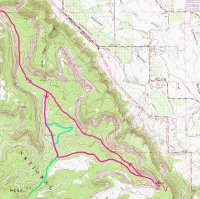
I decided on a hybrid route that came up the Liberty Cap route and then cut into the Mesa on the East side of that plateau, wrapped around the plateau to head out to the northernmost point, and then connected onto the plateau as a route to the Liberty Cap trail on which I returned to the trailhead. The route is shown on this topo map that I'd prepared for the hike.
The route worked out, but was subject to two winter challenges - snow and ice on the ascent trail, which was a real pain on a couple of ice covered slanted stretches, and the very limited daylight time, which meant that I couldn't really linger at the tip of the Mesa.
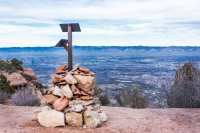
Other than the ice, the ascent is a straightforward climb on a well marked trail. At the top, there's a sign and I headed toward the upper Liberty Cap trailhead for about a quarter mile before veering North off of the trail.
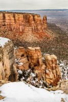
The portion of the route skirting the plateau had relatively heavy vegetation and involved a lot of care to avoid crypto soils of which there was quite a bit of very dense patches. It did yield a nice view of formations on the East side of the Mesa that included a stretch of Grand Valley out to the Book Cliffs.
Along the way, I noticed numerous tracks. Based on very limited expertise, I'd guessed they were from big horns, bobcats, rabbits, and a few from a larger animal - perhaps a deer.
Once out past the northern end of the plateau, I cut across to the West side of the Mesa thinking the view from that side back into Colorado NM would be the better of the two. When I reached the edge, I had a nice view looking up Monument Canyon toward Independence Monument and looking across the canyon to a neighboring mesa.
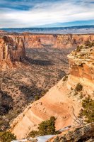
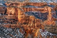
As I moved along the Mesa, the views up toward Independence Monument kept getting better and views across to the "path more travelled" side of the park were good. In particular, I got a different perspective on the kissing couple formation - the second photo below.
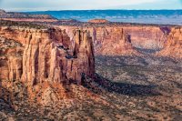
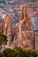
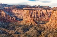
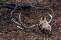
On a grizzlier note, I also came across the head and backbone of a buck deer, confirming my guess about the tracks being deer. There were no other bones around so it appeared to have been worked over pretty thoroughly by local predators / scavengers.
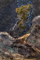
Moving along pretty quickly (having been indoctrinated about hanging around carcasses in sites with bears, which didn't really apply here), I noticed what I thought was a particularly photogenic tree along the rim of the mesa (you have to get artsy sometimes).
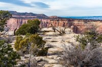
At the end of the Mesa, there's a nice stretch of stones with water pockets leading out to the tip, from which you get a great view of the Monument and the cliffs beyond, including the Saddlehorn formation and the Visitors Center. It's kind of nice to stop and think of the multitudes who've looked across at this spot from that side versus the limited number of them who've hiked out here.
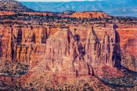
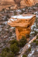
Before heading back to the plateau I swung a bit to the East side of the Mesa to get a shot of Mushroom Rock from above.
The hike back was more straightforward - INTREPIDXJ had chosen the better route (much quicker), though I'm glad I got to see both. When I got to the plateau I knew from his messages that there would be a way up. He'd mentioned stairs, which I didn't find, but found a route up that was pretty straightforward.
The top of the plateau with Otto's Bathtub is a really interesting area with cool erosion features and broad open plazas, though I didn't really get much in the way of photos since I knew I had to hustle to avoid descending the icy trail in the dark (not my idea of fun).
All in all, I found the hike interesting with some very nice views and no stretches of unofficial trail that were very difficult - in fact the icy ascent on the established trail was the most uncomfortable part of the hike.
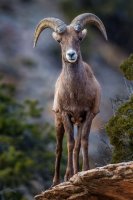
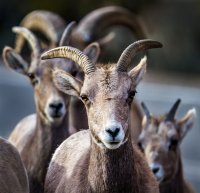
Since I'm talking about the Monument here, I thought I'd throw in a couple of big horn shots from the day before the hike:
If anyone has any questions, I'd be glad to share more about the hike.
Dan
I decided on a hybrid route that came up the Liberty Cap route and then cut into the Mesa on the East side of that plateau, wrapped around the plateau to head out to the northernmost point, and then connected onto the plateau as a route to the Liberty Cap trail on which I returned to the trailhead. The route is shown on this topo map that I'd prepared for the hike.

The route worked out, but was subject to two winter challenges - snow and ice on the ascent trail, which was a real pain on a couple of ice covered slanted stretches, and the very limited daylight time, which meant that I couldn't really linger at the tip of the Mesa.
Other than the ice, the ascent is a straightforward climb on a well marked trail. At the top, there's a sign and I headed toward the upper Liberty Cap trailhead for about a quarter mile before veering North off of the trail.

The portion of the route skirting the plateau had relatively heavy vegetation and involved a lot of care to avoid crypto soils of which there was quite a bit of very dense patches. It did yield a nice view of formations on the East side of the Mesa that included a stretch of Grand Valley out to the Book Cliffs.

Along the way, I noticed numerous tracks. Based on very limited expertise, I'd guessed they were from big horns, bobcats, rabbits, and a few from a larger animal - perhaps a deer.
Once out past the northern end of the plateau, I cut across to the West side of the Mesa thinking the view from that side back into Colorado NM would be the better of the two. When I reached the edge, I had a nice view looking up Monument Canyon toward Independence Monument and looking across the canyon to a neighboring mesa.


As I moved along the Mesa, the views up toward Independence Monument kept getting better and views across to the "path more travelled" side of the park were good. In particular, I got a different perspective on the kissing couple formation - the second photo below.


On a grizzlier note, I also came across the head and backbone of a buck deer, confirming my guess about the tracks being deer. There were no other bones around so it appeared to have been worked over pretty thoroughly by local predators / scavengers.

Moving along pretty quickly (having been indoctrinated about hanging around carcasses in sites with bears, which didn't really apply here), I noticed what I thought was a particularly photogenic tree along the rim of the mesa (you have to get artsy sometimes).

At the end of the Mesa, there's a nice stretch of stones with water pockets leading out to the tip, from which you get a great view of the Monument and the cliffs beyond, including the Saddlehorn formation and the Visitors Center. It's kind of nice to stop and think of the multitudes who've looked across at this spot from that side versus the limited number of them who've hiked out here.


Before heading back to the plateau I swung a bit to the East side of the Mesa to get a shot of Mushroom Rock from above.

The hike back was more straightforward - INTREPIDXJ had chosen the better route (much quicker), though I'm glad I got to see both. When I got to the plateau I knew from his messages that there would be a way up. He'd mentioned stairs, which I didn't find, but found a route up that was pretty straightforward.
The top of the plateau with Otto's Bathtub is a really interesting area with cool erosion features and broad open plazas, though I didn't really get much in the way of photos since I knew I had to hustle to avoid descending the icy trail in the dark (not my idea of fun).
All in all, I found the hike interesting with some very nice views and no stretches of unofficial trail that were very difficult - in fact the icy ascent on the established trail was the most uncomfortable part of the hike.
Since I'm talking about the Monument here, I thought I'd throw in a couple of big horn shots from the day before the hike:


If anyone has any questions, I'd be glad to share more about the hike.
Dan
