RyanP
Member
- Joined
- Mar 1, 2015
- Messages
- 750
Last week, I had the opportunity to return to my all-time favorite backpacking region. From my previous trip there five years ago, I had memories of numerous gorgeous, deserted basins with easy off-trail travel between many of them. This time there were way more people (at least 10x as many---I saw basically nobody for days last time), but we otherwise had phenomenal conditions. Surprisingly, there were almost zero bugs (I packed a bunch of bug spray based on the swarms that I encountered last time at this time of year, but we never even thought about pulling it out). We also had nearly-perfect weather; I think it rained for a total of two hours over the six days, and it was a rare trip that was cool during the peak of the day but also not very cold at night (I'm guessing highs were in the low 60s and lows were around 40 or a touch lower). It was pretty smoky one of the days (I was feeling it in my throat) and sort of hazy two of the other days (affected long-distance views but wasn't too bad), but considering how bad the air quality has been this summer throughout the West, I was very happy with that outcome as well.
I regard this as a "trip of a lifetime"--life doesn't get much better than taking your 16-year-old son for a week-long trip like this. Caleb keeps progressing as an outdoorsman and now I struggle to keep up with him on even the tricky hiking sections. We covered a lot of miles but also took time to explore various viewpoints, swim in lakes, etc. It was the best trip either of us have ever done.
-------- Day 1 --------

We encountered a surprising number of people heading up towards Dad's/etc. I think the majority of them were doing the T. Pass Loop through the Cirque. I'm guessing some of them were in for a shock when they encountered T. Pass...
We soon left the crowds behind and took the trail heading towards the Southern entrance to the E. F. valley.

We left the trail, crossed the stream, and headed up the E. F. valley. It was easy-going and beautiful, and soon we got to our campsite area for the first night.

This was one of my all-time favorite campsites (I used the same spot on my last trip), with a nice flat spot for a small tent nestled in the trees, near a wonderful river flowing over the granite and with long-distance views of the E. F. Peaks. It seems like not many people camp here and there are a lot of good campsite opportunities in the E. F. (I think most "high route" hikers camp a little further up the valley).

-------- Day 2 --------
The first couple of miles of Day 2 featured some of the easiest and nicest off-trail travel imaginable. You basically walk though grass meadows and through sparse woods and approach the towering peaks. It was just as glorious as I remembered.


We climbed up the hill to P. Lake and made the direct ascent to H. Pass rather than the roundabout way on the trails.


The funny thing is, after all of that off-trail travel, the trail down the North side of H. Pass was the trickiest/sketchiest part of the trip so far (it's not too bad though). We made it down the loose trail and hiked up the gorgeous trail towards the beautiful B. Lake. The trail was much easier to follow this time; I'm guessing this area just gets way more visitors these days.

We took some time exploring around B. Lake. I remember reading a discussion (probably on this site) where people were describing B. Lake as barren and not as nice as the other lakes in the region. I highly disagree. B. Lake is probably my favorite spot in the whole region, and might be my favorite lake of all time (Caleb had the same opinion). We shared the lake with a very experienced backpacker named Duff who has done around 50 trips in this range over the last 50 years. He agreed that B. Lake is a special place and it was his eighth time visiting it.


-------- Day 3 --------
We woke up and were surprised at how smoky/hazy it was all of a sudden this morning. Today's hike would be the easiest of the trip and would allow us to save our energy for the tough back-to-back-to-back days at the end of the trip. Most of the day was on-trail, and even the "off-trail" section has a nice trail if you know where to find it. I had never been to G. Lake, and the hike around it did not disappoint. It is a huge lake and had a totally different feel than the previous days (almost felt like an entirely different part of the country):


One of my biggest regrets on this trip was deciding not to swim in G. Lake. It was cool and windy at the time, so a swim sounded cold and unpleasant. But right after leaving the lake we started hiking uphill through the trees (no wind) and it started feeling hot, so a swim would have been perfect! G. Lake even has nice sandy beach sections:


The next section through the trees was relatively boring, and I was starting to wish that we had taken the M. Lakes Pass route that I took last time (which was extremely spectacular, but also much harder). But as soon as I started having these thoughts, we got to yet another beautiful stretch of trail with P. Peak dominating the view:

We then made our way up the trail towards V. Lake. Air quality was bad and my throat was getting pretty sore. We took the use trail to S. F. Lakes and my spirits instantly improved. We swam out to the island in the first off-trail lake there ("Upper V. Lake"?), and meandered down the faint trail up to the remaining S. F. Lakes.


Photos don't capture how spectacular this basin is. There's a gorgeous collection of lakes with rugged peaks all around, with a waterfall coming all the way down from the L. H. Plateau above (seeing that waterfall was nice because we knew we would have a good stream on the L. H. Plateau the next morning!). There are a number of good campsite options in the area as well (although some are pretty exposed to the elements).
-------- Day 4 --------
Camping at S. F. Lakes was perhaps my favorite part of the entire trip. Last time I came through this area, I was blown away by how awesome it was, but I was in a rush and didn't have time to enjoy it properly (I was trying to get up and down the L. H. trail before the bad weather came--I lost that race...). This time, we had plenty of time in the evening to explore and soak it in, and then we were greeted with glorious morning conditions:


We made our way up the drainage to the plateau on top, as described in the guide book. Last time I struggled with this section, but this time it seemed pretty easy (maybe I took the wrong gully up last time?). We absolutely loved this section.

We eventually made it to the top of the plateau and the views were amazing down toward the basin:

The L. H. trail is one of my all-time favorite trails, and we were lucky that the smoke/haze from the day before had mostly cleared out.


Once we got down to the popular trail below, we swung a left and actually headed away from the Cirque. The rest of the trip would almost all be new for me, and was inspired by this report. The first mile or so had some really nice views:

I convinced Caleb that we should explore off-trail to P. Lake (only 0.1 or 0.2 miles from the main trail). We were bushwhacking on the way there, but the side trip was so worth it. Swimming in P. Lake capped off my favorite half-day stretch of the trip. Then, of course, we found there was a use trail that basically went back from P. Lake to the main trail. It took us much less time and effort to get back to the trail!

The next handful of miles were relatively uninteresting. Eventually we climbed the trail toward the I. Lakes/D. C. Lakes area, and the scenery started to improve as we passed a number of small ponds:

The D.C. Lakes are nice. As you go from the lower lake to the middle lake to the upper lake, the use trail goes from solid to faint to nonexistent, and the scenery continually improves. Here's the Lower D. C. Lake:

The clouds were really coming in that evening, so we set up camp at the Middle D. C. Lake. I had never previously done a fire while backpacking (for various reasons), but when we got to our campsite I saw that there was a nice fire ring, and the previous campers had left a pile of nice sticks of various sizes, and I knew there was not a fire ban in place, and our feet were soggy, and it was early enough for a fire...

-------- Day 5 --------
I don't think the D. C. Lakes area is quite as nice as some of the other spectacular basins we visited on this trip, but they were still very nice. We had a nice view from our camp of the outlet stream and Lower D. C. Lake below, with the clouds coming in below that:

Middle D. C. Lake:


The hike between Middle and Upper D. C. Lakes consisted of fun off-trail travel:

The upper lake was definitely the most spectacular and least-visited; I wished we had taken the extra time and effort to make it this far the previous evening.

From there, we basically gained the ridge of W. R. Peak and started working our way up.

The talus toward the top of W. R. Peak was slow and tedious, but Caleb had a fun time with it and we eventually got to the top. The photos turned out bad from the peak due to the haze, but the view in person was spectacular. It was fun seeing so many of the distant mountains (L. H. Peak, etc) and lakes that we had either already seen in our trip or were going to see later.


We had a lot more fun going down the other side of the peak. My impression was that it would be worse going down, but I think with that medium-size stable talus, it's just easier going down than up. It didn't take us too long to get to the grass and wildflowers, and the views to the South were incredible.


We finally got to a trail (our first of the day), but only followed it for a fraction of a mile before we decided to try an off-trail shortcut to avoid the roundabout trails to C. Lake. The off-trail shortcut had a short marshy section at the beginning, but was otherwise great. We basically followed elk trails to C. Lake.

We finally took out our tent and sleeping bags to dry in the late afternoon sun (they had gotten wet from condensation the previous night), and in the meantime I took a dip in the beautiful lake:

We then made our way around the lake to go find the "C. Lake Pass" down to the L. S. creek below.

We explored a little to find the best way down the slope to the valley below. There was a flat bench overlooking the valley below that would have made an awesome campsite!

There were also a couple of spectacular little ponds in this same area:


We eventually found the right way down to the valley below; it involved backtracking almost to the lake and heading further up and North before heading down a network of gullies and game trails. I broke one of my hiking poles in this section.

We found a nice flat spot to camp near the creek at the bottom. There was elk scat and prints all over the place near our campsite, just like throughout much of the trip, but unfortunately we never saw any elk or other significant wildlife (a common theme on my trips to this range!).
-------- Day 6 --------
I thought there would be at least some kind of trail heading up the valley, but we sure didn't find one until we were almost at the top of T. Peak Pass. The off-trail travel most of the way up the basin was easy and beautiful though.


This was super random and weird: an old, rusted bedframe (a quite heavy one at that!), but with no other sign of a cabin or anything else. Anyone know the backstory?

The basin was beautiful all the way up to T. Peak Pass:

Gaining the pass itself was kind of a pain. It was pretty steep and had some loose sections. For some reason I had the impression that this pass would be easier. Caleb handled it fine though, and it wasn't really too sketchy (for example, we never had to stash our trekking poles to use our hands). It was also a short climb. Toward the top, we gained a trail, and that made the rest of the ascent much easier.
T. Peak pass had a spectacular view to the North toward the Cirque, but it was pretty hazy and the view was limited in its scope (it wasn't even close to a 180 degree view let alone panoramic). I think the view actually got nicer as we got a little lower. The trail down the North side of T. Peak pass made travel pretty easy.


I didn't take many photos of the next stretch, as my phone was running low on batteries, but the stretch of trail between T. Lake and D. Lake (and all the way to C. Lake really) completely blew me away. I was expecting it to be a very-nice-but-crowded area (since it's easier to get to than most of these other areas). It turned out to be easily one of the most spectacular stretches of the entire trip, with super-easy trail and towering peaks and gorgeous lakes in all directions. We only say a handful of groups in this section (on a Saturday in early August) as well. If you wanted to do a short/easy trip into the Winds (something I generally do NOT recommend, since the drive and hike in is long enough to not make it worth it for short/easy trips), I think this area would be my top recommendation.

This area was just heavenly. Below D. Lake is extensive low-angle granite with various shallow streams running down the granite and forming small pools. We spent a fair amount of time just hanging out in this area. What a great way to end the trip.


We then booked it down the trail from B. S. Lake back to the car. When doing this mundane stretch, we added up the totals for the trip and I think we covered about 65 miles with about 40% of our time being off-trail. This is the longest trip I have done, but both the on-trail and off-trail sections are pretty easy in this region and it wasn't the hardest trip for either of us. The famous Cirque is indeed spectacular and worth a visit, but I highly recommend seeing a bunch of the other basins around it as well!
I regard this as a "trip of a lifetime"--life doesn't get much better than taking your 16-year-old son for a week-long trip like this. Caleb keeps progressing as an outdoorsman and now I struggle to keep up with him on even the tricky hiking sections. We covered a lot of miles but also took time to explore various viewpoints, swim in lakes, etc. It was the best trip either of us have ever done.
-------- Day 1 --------
We encountered a surprising number of people heading up towards Dad's/etc. I think the majority of them were doing the T. Pass Loop through the Cirque. I'm guessing some of them were in for a shock when they encountered T. Pass...
We soon left the crowds behind and took the trail heading towards the Southern entrance to the E. F. valley.
We left the trail, crossed the stream, and headed up the E. F. valley. It was easy-going and beautiful, and soon we got to our campsite area for the first night.
This was one of my all-time favorite campsites (I used the same spot on my last trip), with a nice flat spot for a small tent nestled in the trees, near a wonderful river flowing over the granite and with long-distance views of the E. F. Peaks. It seems like not many people camp here and there are a lot of good campsite opportunities in the E. F. (I think most "high route" hikers camp a little further up the valley).
-------- Day 2 --------
The first couple of miles of Day 2 featured some of the easiest and nicest off-trail travel imaginable. You basically walk though grass meadows and through sparse woods and approach the towering peaks. It was just as glorious as I remembered.
We climbed up the hill to P. Lake and made the direct ascent to H. Pass rather than the roundabout way on the trails.
The funny thing is, after all of that off-trail travel, the trail down the North side of H. Pass was the trickiest/sketchiest part of the trip so far (it's not too bad though). We made it down the loose trail and hiked up the gorgeous trail towards the beautiful B. Lake. The trail was much easier to follow this time; I'm guessing this area just gets way more visitors these days.
We took some time exploring around B. Lake. I remember reading a discussion (probably on this site) where people were describing B. Lake as barren and not as nice as the other lakes in the region. I highly disagree. B. Lake is probably my favorite spot in the whole region, and might be my favorite lake of all time (Caleb had the same opinion). We shared the lake with a very experienced backpacker named Duff who has done around 50 trips in this range over the last 50 years. He agreed that B. Lake is a special place and it was his eighth time visiting it.
-------- Day 3 --------
We woke up and were surprised at how smoky/hazy it was all of a sudden this morning. Today's hike would be the easiest of the trip and would allow us to save our energy for the tough back-to-back-to-back days at the end of the trip. Most of the day was on-trail, and even the "off-trail" section has a nice trail if you know where to find it. I had never been to G. Lake, and the hike around it did not disappoint. It is a huge lake and had a totally different feel than the previous days (almost felt like an entirely different part of the country):
One of my biggest regrets on this trip was deciding not to swim in G. Lake. It was cool and windy at the time, so a swim sounded cold and unpleasant. But right after leaving the lake we started hiking uphill through the trees (no wind) and it started feeling hot, so a swim would have been perfect! G. Lake even has nice sandy beach sections:
The next section through the trees was relatively boring, and I was starting to wish that we had taken the M. Lakes Pass route that I took last time (which was extremely spectacular, but also much harder). But as soon as I started having these thoughts, we got to yet another beautiful stretch of trail with P. Peak dominating the view:
We then made our way up the trail towards V. Lake. Air quality was bad and my throat was getting pretty sore. We took the use trail to S. F. Lakes and my spirits instantly improved. We swam out to the island in the first off-trail lake there ("Upper V. Lake"?), and meandered down the faint trail up to the remaining S. F. Lakes.
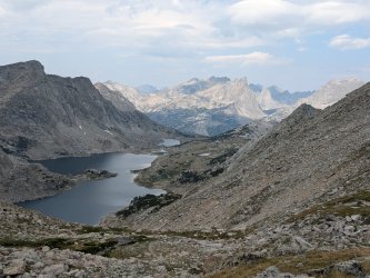
Photos don't capture how spectacular this basin is. There's a gorgeous collection of lakes with rugged peaks all around, with a waterfall coming all the way down from the L. H. Plateau above (seeing that waterfall was nice because we knew we would have a good stream on the L. H. Plateau the next morning!). There are a number of good campsite options in the area as well (although some are pretty exposed to the elements).
-------- Day 4 --------
Camping at S. F. Lakes was perhaps my favorite part of the entire trip. Last time I came through this area, I was blown away by how awesome it was, but I was in a rush and didn't have time to enjoy it properly (I was trying to get up and down the L. H. trail before the bad weather came--I lost that race...). This time, we had plenty of time in the evening to explore and soak it in, and then we were greeted with glorious morning conditions:
We made our way up the drainage to the plateau on top, as described in the guide book. Last time I struggled with this section, but this time it seemed pretty easy (maybe I took the wrong gully up last time?). We absolutely loved this section.
We eventually made it to the top of the plateau and the views were amazing down toward the basin:
The L. H. trail is one of my all-time favorite trails, and we were lucky that the smoke/haze from the day before had mostly cleared out.
Once we got down to the popular trail below, we swung a left and actually headed away from the Cirque. The rest of the trip would almost all be new for me, and was inspired by this report. The first mile or so had some really nice views:
I convinced Caleb that we should explore off-trail to P. Lake (only 0.1 or 0.2 miles from the main trail). We were bushwhacking on the way there, but the side trip was so worth it. Swimming in P. Lake capped off my favorite half-day stretch of the trip. Then, of course, we found there was a use trail that basically went back from P. Lake to the main trail. It took us much less time and effort to get back to the trail!
The next handful of miles were relatively uninteresting. Eventually we climbed the trail toward the I. Lakes/D. C. Lakes area, and the scenery started to improve as we passed a number of small ponds:
The D.C. Lakes are nice. As you go from the lower lake to the middle lake to the upper lake, the use trail goes from solid to faint to nonexistent, and the scenery continually improves. Here's the Lower D. C. Lake:
The clouds were really coming in that evening, so we set up camp at the Middle D. C. Lake. I had never previously done a fire while backpacking (for various reasons), but when we got to our campsite I saw that there was a nice fire ring, and the previous campers had left a pile of nice sticks of various sizes, and I knew there was not a fire ban in place, and our feet were soggy, and it was early enough for a fire...
-------- Day 5 --------
I don't think the D. C. Lakes area is quite as nice as some of the other spectacular basins we visited on this trip, but they were still very nice. We had a nice view from our camp of the outlet stream and Lower D. C. Lake below, with the clouds coming in below that:
Middle D. C. Lake:
The hike between Middle and Upper D. C. Lakes consisted of fun off-trail travel:
The upper lake was definitely the most spectacular and least-visited; I wished we had taken the extra time and effort to make it this far the previous evening.
From there, we basically gained the ridge of W. R. Peak and started working our way up.
The talus toward the top of W. R. Peak was slow and tedious, but Caleb had a fun time with it and we eventually got to the top. The photos turned out bad from the peak due to the haze, but the view in person was spectacular. It was fun seeing so many of the distant mountains (L. H. Peak, etc) and lakes that we had either already seen in our trip or were going to see later.
We had a lot more fun going down the other side of the peak. My impression was that it would be worse going down, but I think with that medium-size stable talus, it's just easier going down than up. It didn't take us too long to get to the grass and wildflowers, and the views to the South were incredible.
We finally got to a trail (our first of the day), but only followed it for a fraction of a mile before we decided to try an off-trail shortcut to avoid the roundabout trails to C. Lake. The off-trail shortcut had a short marshy section at the beginning, but was otherwise great. We basically followed elk trails to C. Lake.
We finally took out our tent and sleeping bags to dry in the late afternoon sun (they had gotten wet from condensation the previous night), and in the meantime I took a dip in the beautiful lake:
We then made our way around the lake to go find the "C. Lake Pass" down to the L. S. creek below.
We explored a little to find the best way down the slope to the valley below. There was a flat bench overlooking the valley below that would have made an awesome campsite!
There were also a couple of spectacular little ponds in this same area:
We eventually found the right way down to the valley below; it involved backtracking almost to the lake and heading further up and North before heading down a network of gullies and game trails. I broke one of my hiking poles in this section.
We found a nice flat spot to camp near the creek at the bottom. There was elk scat and prints all over the place near our campsite, just like throughout much of the trip, but unfortunately we never saw any elk or other significant wildlife (a common theme on my trips to this range!).
-------- Day 6 --------
I thought there would be at least some kind of trail heading up the valley, but we sure didn't find one until we were almost at the top of T. Peak Pass. The off-trail travel most of the way up the basin was easy and beautiful though.
This was super random and weird: an old, rusted bedframe (a quite heavy one at that!), but with no other sign of a cabin or anything else. Anyone know the backstory?
The basin was beautiful all the way up to T. Peak Pass:
Gaining the pass itself was kind of a pain. It was pretty steep and had some loose sections. For some reason I had the impression that this pass would be easier. Caleb handled it fine though, and it wasn't really too sketchy (for example, we never had to stash our trekking poles to use our hands). It was also a short climb. Toward the top, we gained a trail, and that made the rest of the ascent much easier.
T. Peak pass had a spectacular view to the North toward the Cirque, but it was pretty hazy and the view was limited in its scope (it wasn't even close to a 180 degree view let alone panoramic). I think the view actually got nicer as we got a little lower. The trail down the North side of T. Peak pass made travel pretty easy.
I didn't take many photos of the next stretch, as my phone was running low on batteries, but the stretch of trail between T. Lake and D. Lake (and all the way to C. Lake really) completely blew me away. I was expecting it to be a very-nice-but-crowded area (since it's easier to get to than most of these other areas). It turned out to be easily one of the most spectacular stretches of the entire trip, with super-easy trail and towering peaks and gorgeous lakes in all directions. We only say a handful of groups in this section (on a Saturday in early August) as well. If you wanted to do a short/easy trip into the Winds (something I generally do NOT recommend, since the drive and hike in is long enough to not make it worth it for short/easy trips), I think this area would be my top recommendation.
This area was just heavenly. Below D. Lake is extensive low-angle granite with various shallow streams running down the granite and forming small pools. We spent a fair amount of time just hanging out in this area. What a great way to end the trip.
We then booked it down the trail from B. S. Lake back to the car. When doing this mundane stretch, we added up the totals for the trip and I think we covered about 65 miles with about 40% of our time being off-trail. This is the longest trip I have done, but both the on-trail and off-trail sections are pretty easy in this region and it wasn't the hardest trip for either of us. The famous Cirque is indeed spectacular and worth a visit, but I highly recommend seeing a bunch of the other basins around it as well!
Attachments
Last edited:


")