IntrepidXJ
ADVENTR
- Joined
- Jan 17, 2012
- Messages
- 3,493
Friday - Sunday, March 14-16, 2014
The Original Trip Report on ADVENTR.CO
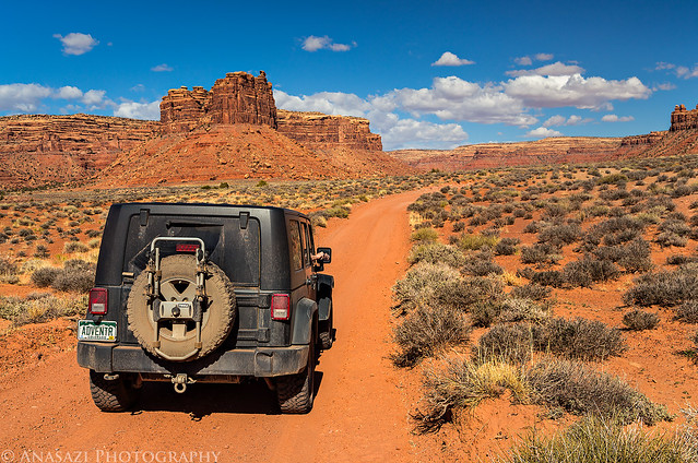
On Friday morning, Diane and I headed south towards Cedar Mesa in southern Utah to spend a long weekend hiking, camping and searching for some new rock art sites along the way. While the weather was nice during the days it was still a bit cold overnight and in the mornings, especially on Sunday morning when it dropped down to the low 20's when we woke up around sunrise. Friday was a little breezy with nice clouds in the sky but Saturday was very windy. We got sand-blasted on Saturday pretty good while searching boulders for petroglyphs in the afternoon. When Sunday arrived the winds had finally calmed down and the skies had cleared. We had a great weekend and managed to find everything we were looking for.
Cedar Mesa hiking at it's finest.

Cedar Mesa Hiking by IntrepidXJ, on Flickr
Just a small panel of petroglyphs we spotted above.

High Tracks by IntrepidXJ, on Flickr
Looking up at the amazing Hunt Panel.

Hunt Panel Wall by IntrepidXJ, on Flickr
A better view of this panel. I had to climb a tree for this shot...

Hunt Panel by IntrepidXJ, on Flickr
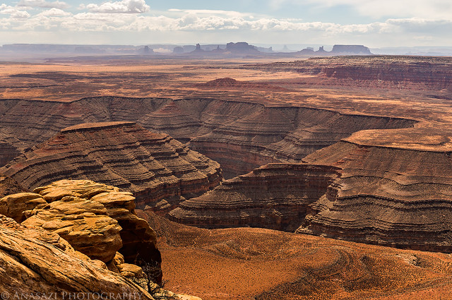
A view of Cedar Point from the Muley Point overlook.

Cedar Point by IntrepidXJ, on Flickr
The wind kicked up quite a bit of dust around Monument Valley in the distance.
Dusty View by IntrepidXJ, on Flickr
There was nice spotted light in the canyon of the San Juan River when we made a quick stop at Goosenecks State Park.
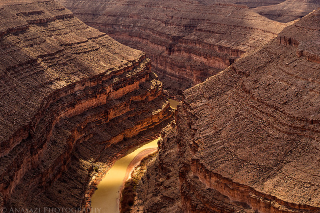
Spotlight by IntrepidXJ, on Flickr
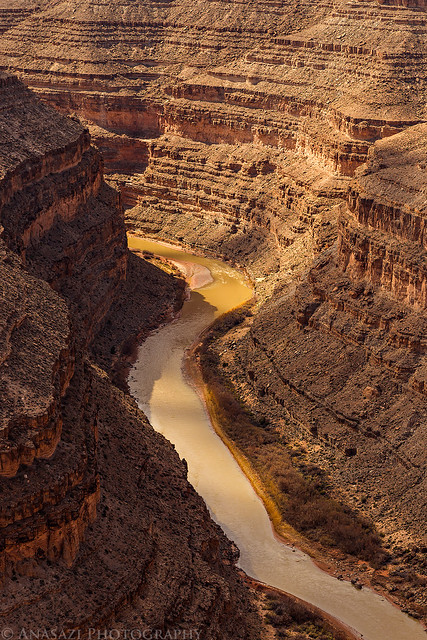
San Juan River by IntrepidXJ, on Flickr
On our way to visit a few well-known petroglyphs.
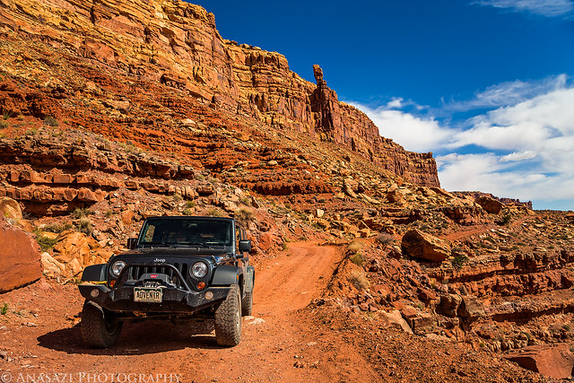
Johns Canyon Road by IntrepidXJ, on Flickr
A quick stop at the small Dotted Man panel right next to the road.

Dotted Man by IntrepidXJ, on Flickr
The impressive Duckhead Man.

Duckhead Man by IntrepidXJ, on Flickr
A lonely desert road...does it get any better?
Desert Road by IntrepidXJ, on Flickr
Duckhead figures and lines of dancers seemed to be the reoccurring theme this weekend.

The Dance by IntrepidXJ, on Flickr
This was an amazing panel we came across. The evening light and clouds in the sky cooperated, too!

Growth Panel by IntrepidXJ, on Flickr
The striped surface of this boulder creates an interesting backdrop for the petroglyph panel.

Striped Panel by IntrepidXJ, on Flickr

Striped Panel Detail by IntrepidXJ, on Flickr
Searching a jumble of large boulders for scattered petroglyphs.

Boulders by IntrepidXJ, on Flickr
Following the glow of reflected light through a small passage.

Hidden Passage by IntrepidXJ, on Flickr
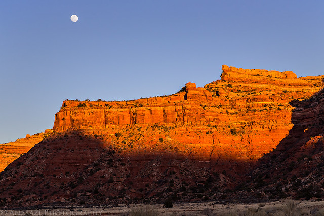
As we were setting up camp for the evening I looked up and couldn't help but notice the almost-full moon rising above the canyon rim.

Moonrise by IntrepidXJ, on Flickr
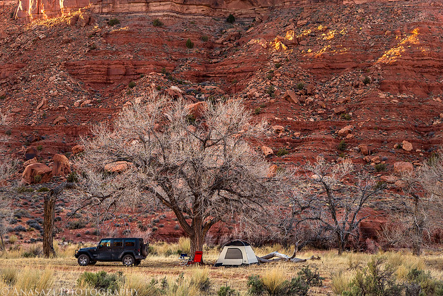
Our camp under the winter skeleton of a large cottonwood tree. I'm sure this setting would look even more impressive in the fall.
Camp by IntrepidXJ, on Flickr
Evening shadows on the canyon walls as the sun gets ready to set for the day.
Evening Shadow by IntrepidXJ, on Flickr
Saturday morning brought more exploring through large boulders.

Diane by IntrepidXJ, on Flickr

Exploring by IntrepidXJ, on Flickr
We visited this unique panel known as The Obelisk.

The Obelisk by IntrepidXJ, on Flickr
A closer look at the petroglyphs.

Obelisk Scene by IntrepidXJ, on Flickr
We spent much of the very windy afternoon searching for petroglyphs on many large boulders...

Falling by IntrepidXJ, on Flickr
...until I finally found the boulder I was looking for: The Tilted Boulder! The interesting thing about this boulder is that the oldest Glen Canyon Style petroglyphs found on it are rotated 90 degrees since it appears the boulder has fallen over since they were originally created. Newer petroglyphs were pecked into the same boulder in it's new orientation. Very cool!

Tilted Boulder by IntrepidXJ, on Flickr
Here's a closer look at the older petroglyphs, rotated for easier viewing!

Tilted Man by IntrepidXJ, on Flickr

Tilted Panel by IntrepidXJ, on Flickr
Nice spotlight on Cedar Mesa is created by fast moving clouds in the sky.

Cedar Mesa Light by IntrepidXJ, on Flickr
Before driving into Bluff for an early dinner at the Twin Rocks Cafe we visited The Dancer Panel.

The Dancer Panel by IntrepidXJ, on Flickr

Dancers by IntrepidXJ, on Flickr

Dancers & Spirals by IntrepidXJ, on Flickr

Dancers Panel by IntrepidXJ, on Flickr
After dinner we visited Pedestal Ruin before finding a spot to setup camp for the night.

Ledge Ruin by IntrepidXJ, on Flickr
A closer look at the precarious location of this ruin.

House on the Ledge by IntrepidXJ, on Flickr
Our shadows in the warm evening light.

Shadows by IntrepidXJ, on Flickr

Rockfall by IntrepidXJ, on Flickr
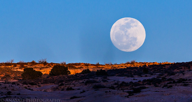
The full moon makes an appearance over the sandstone as we setup our camp along Butler Wash.
Moon Over Sandstone by IntrepidXJ, on Flickr
On Sunday morning we started out our day by hiking up to the impressive Fishmouth Cave in Comb Ridge. I had made this hike years ago, but didn't really remember much about it, so I wanted to refresh my memory and hopefully take some better photos.
We passed a few alcoves containing ruins in this short canyon.

Walls by IntrepidXJ, on Flickr
The reflected light was nice when we reached this large alcove filled with ruins.

Comb Ridge Ruin by IntrepidXJ, on Flickr

Comb Ridge Alcove by IntrepidXJ, on Flickr

All That Remains by IntrepidXJ, on Flickr
Besides the unfortunate amount of graffiti in the back of Fishmouth Cave there were a few reverse handprints.

Fishmouth Hands by IntrepidXJ, on Flickr
The view out of this massive alcove.

Fishmouth View by IntrepidXJ, on Flickr
We passed these more recent petroglyphs of a horse and elk on our way back to the highway.

Horse & Elk by IntrepidXJ, on Flickr
Our next stop was to try and find the Polychrome Shelter, which we did. There were plenty of pictographs in this small alcove.

Polychrome Shelter by IntrepidXJ, on Flickr
Hard to see, but there are two green figures painted in the middle of this photo.

Green Twins by IntrepidXJ, on Flickr
A lot of small flute players found here.

Flute Players by IntrepidXJ, on Flickr

White Pictographs by IntrepidXJ, on Flickr
We made one last stop at Three Kiva Pueblo before starting our drive home. The light beam was nice!

Kiva Light by IntrepidXJ, on Flickr

Kiva by IntrepidXJ, on Flickr
I'm not sure when or why these moki steps were carved up to this alcove in Montezuma Canyon, but it must have been important for someone to go through all the trouble?

Moki Steps by IntrepidXJ, on Flickr
One last quick stop along the Colorado River for a photo of the Fisher Towers.
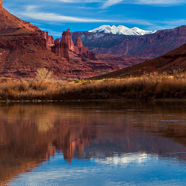
Fisher Towers by IntrepidXJ, on Flickr
>> Cedar Mesa & Beyond Photo Gallery
Featured image for home page:

The Original Trip Report on ADVENTR.CO
On Friday morning, Diane and I headed south towards Cedar Mesa in southern Utah to spend a long weekend hiking, camping and searching for some new rock art sites along the way. While the weather was nice during the days it was still a bit cold overnight and in the mornings, especially on Sunday morning when it dropped down to the low 20's when we woke up around sunrise. Friday was a little breezy with nice clouds in the sky but Saturday was very windy. We got sand-blasted on Saturday pretty good while searching boulders for petroglyphs in the afternoon. When Sunday arrived the winds had finally calmed down and the skies had cleared. We had a great weekend and managed to find everything we were looking for.
Cedar Mesa hiking at it's finest.
Cedar Mesa Hiking by IntrepidXJ, on Flickr
Just a small panel of petroglyphs we spotted above.
High Tracks by IntrepidXJ, on Flickr
Looking up at the amazing Hunt Panel.
Hunt Panel Wall by IntrepidXJ, on Flickr
A better view of this panel. I had to climb a tree for this shot...
Hunt Panel by IntrepidXJ, on Flickr
A view of Cedar Point from the Muley Point overlook.
Cedar Point by IntrepidXJ, on Flickr
The wind kicked up quite a bit of dust around Monument Valley in the distance.
Dusty View by IntrepidXJ, on Flickr
There was nice spotted light in the canyon of the San Juan River when we made a quick stop at Goosenecks State Park.
Spotlight by IntrepidXJ, on Flickr
San Juan River by IntrepidXJ, on Flickr
On our way to visit a few well-known petroglyphs.
Johns Canyon Road by IntrepidXJ, on Flickr
A quick stop at the small Dotted Man panel right next to the road.
Dotted Man by IntrepidXJ, on Flickr
The impressive Duckhead Man.
Duckhead Man by IntrepidXJ, on Flickr
A lonely desert road...does it get any better?
Desert Road by IntrepidXJ, on Flickr
Duckhead figures and lines of dancers seemed to be the reoccurring theme this weekend.
The Dance by IntrepidXJ, on Flickr
This was an amazing panel we came across. The evening light and clouds in the sky cooperated, too!
Growth Panel by IntrepidXJ, on Flickr
The striped surface of this boulder creates an interesting backdrop for the petroglyph panel.
Striped Panel by IntrepidXJ, on Flickr
Striped Panel Detail by IntrepidXJ, on Flickr
Searching a jumble of large boulders for scattered petroglyphs.
Boulders by IntrepidXJ, on Flickr
Following the glow of reflected light through a small passage.
Hidden Passage by IntrepidXJ, on Flickr
As we were setting up camp for the evening I looked up and couldn't help but notice the almost-full moon rising above the canyon rim.
Moonrise by IntrepidXJ, on Flickr
Our camp under the winter skeleton of a large cottonwood tree. I'm sure this setting would look even more impressive in the fall.
Camp by IntrepidXJ, on Flickr
Evening shadows on the canyon walls as the sun gets ready to set for the day.
Evening Shadow by IntrepidXJ, on Flickr
Saturday morning brought more exploring through large boulders.
Diane by IntrepidXJ, on Flickr
Exploring by IntrepidXJ, on Flickr
We visited this unique panel known as The Obelisk.
The Obelisk by IntrepidXJ, on Flickr
A closer look at the petroglyphs.
Obelisk Scene by IntrepidXJ, on Flickr
We spent much of the very windy afternoon searching for petroglyphs on many large boulders...
Falling by IntrepidXJ, on Flickr
...until I finally found the boulder I was looking for: The Tilted Boulder! The interesting thing about this boulder is that the oldest Glen Canyon Style petroglyphs found on it are rotated 90 degrees since it appears the boulder has fallen over since they were originally created. Newer petroglyphs were pecked into the same boulder in it's new orientation. Very cool!
Tilted Boulder by IntrepidXJ, on Flickr
Here's a closer look at the older petroglyphs, rotated for easier viewing!
Tilted Man by IntrepidXJ, on Flickr
Tilted Panel by IntrepidXJ, on Flickr
Nice spotlight on Cedar Mesa is created by fast moving clouds in the sky.
Cedar Mesa Light by IntrepidXJ, on Flickr
Before driving into Bluff for an early dinner at the Twin Rocks Cafe we visited The Dancer Panel.
The Dancer Panel by IntrepidXJ, on Flickr
Dancers by IntrepidXJ, on Flickr
Dancers & Spirals by IntrepidXJ, on Flickr
Dancers Panel by IntrepidXJ, on Flickr
After dinner we visited Pedestal Ruin before finding a spot to setup camp for the night.
Ledge Ruin by IntrepidXJ, on Flickr
A closer look at the precarious location of this ruin.
House on the Ledge by IntrepidXJ, on Flickr
Our shadows in the warm evening light.
Shadows by IntrepidXJ, on Flickr
Rockfall by IntrepidXJ, on Flickr
The full moon makes an appearance over the sandstone as we setup our camp along Butler Wash.
Moon Over Sandstone by IntrepidXJ, on Flickr
On Sunday morning we started out our day by hiking up to the impressive Fishmouth Cave in Comb Ridge. I had made this hike years ago, but didn't really remember much about it, so I wanted to refresh my memory and hopefully take some better photos.
We passed a few alcoves containing ruins in this short canyon.
Walls by IntrepidXJ, on Flickr
The reflected light was nice when we reached this large alcove filled with ruins.
Comb Ridge Ruin by IntrepidXJ, on Flickr
Comb Ridge Alcove by IntrepidXJ, on Flickr
All That Remains by IntrepidXJ, on Flickr
Besides the unfortunate amount of graffiti in the back of Fishmouth Cave there were a few reverse handprints.
Fishmouth Hands by IntrepidXJ, on Flickr
The view out of this massive alcove.
Fishmouth View by IntrepidXJ, on Flickr
We passed these more recent petroglyphs of a horse and elk on our way back to the highway.
Horse & Elk by IntrepidXJ, on Flickr
Our next stop was to try and find the Polychrome Shelter, which we did. There were plenty of pictographs in this small alcove.
Polychrome Shelter by IntrepidXJ, on Flickr
Hard to see, but there are two green figures painted in the middle of this photo.
Green Twins by IntrepidXJ, on Flickr
A lot of small flute players found here.
Flute Players by IntrepidXJ, on Flickr
White Pictographs by IntrepidXJ, on Flickr
We made one last stop at Three Kiva Pueblo before starting our drive home. The light beam was nice!
Kiva Light by IntrepidXJ, on Flickr
Kiva by IntrepidXJ, on Flickr
I'm not sure when or why these moki steps were carved up to this alcove in Montezuma Canyon, but it must have been important for someone to go through all the trouble?
Moki Steps by IntrepidXJ, on Flickr
One last quick stop along the Colorado River for a photo of the Fisher Towers.
Fisher Towers by IntrepidXJ, on Flickr
>> Cedar Mesa & Beyond Photo Gallery
Featured image for home page:
