Joey
walking somewhere
- Joined
- Apr 1, 2014
- Messages
- 878
This is a fun 3 day backpack I did last April. It includes both Upper and Lower Spring Canyon, Grand Wash, the Frying Pan Trail, and the Sulphur Creek Route. I started and ended at Holt Draw. The last few miles up Sulphur Creek were outside the park boundary. I did not take many pictures, but will post what I have below in a mini trip report. I do have a trip video which is all footage you can watch here:
Now here is the route maps:


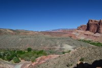
Day one I started at Holt Draw, and hiked a few miles before reaching Upper Spring Canyon. The canyon is more open in the upper section. Still pretty.


Water was plentiful in several spots as I got closer to the Chimney Rock Canyon junction. I set up camp above a large bend in the canyon, maybe a mile before the junction.

Day 2 I hiked all the way down Lower Spring Canyon. I did not take any pictures while in this section, and I don't remember why. I do have some good video clips in my trip video above. I really enjoy the lower canyon, one of the highlights of this trip. There is another spring down the canyon, and a pour off you bypass on a short side trail. I had to cross the Freemont River when I reached the end of the canyon. It was pretty easy. I've done this before earlier in the spring, and its a lot colder and deeper.

After crossing the river, I followed the road south for a few minutes, before heading into Grand Wash. There is a nice short stretch of narrow, and then it opens up a bit. Again, minimal pictures.


Next up I climbed up the Frying Pan Trail, passing Cassidy Arch.


The wind was strong and cold, so I decided to drop down a little bit to camp.


Day 3 was sunny and cool. I headed down into Cohab Canyon, and then dropped down to the visitor center.


Next up was Sulphur Creek. I had been looking at this route for several years, but never had the chance to do it. I was impressed. A very fun hike. I enjoyed it so much, that I hiked it again a few days later with @McGimpkins . To enhance this report, I've include a few of the photos from both trips. The water was higher and faster on my first trip through. There are 3 waterfalls to get past, all easy stuff. But it feels like your on a Disney ride when walking up the creek. Very cool.


.JPG")
.JPG")


It took me longer than I though to get all the way back to my vehicle at Holt Draw. It was a few hours of hiking outside the park boundary. The section outside the park is pretty, and nice campsites exist. Then it opens up into to cow country. Awesome trip.
Now here is the route maps:
Day one I started at Holt Draw, and hiked a few miles before reaching Upper Spring Canyon. The canyon is more open in the upper section. Still pretty.
Water was plentiful in several spots as I got closer to the Chimney Rock Canyon junction. I set up camp above a large bend in the canyon, maybe a mile before the junction.
Day 2 I hiked all the way down Lower Spring Canyon. I did not take any pictures while in this section, and I don't remember why. I do have some good video clips in my trip video above. I really enjoy the lower canyon, one of the highlights of this trip. There is another spring down the canyon, and a pour off you bypass on a short side trail. I had to cross the Freemont River when I reached the end of the canyon. It was pretty easy. I've done this before earlier in the spring, and its a lot colder and deeper.
After crossing the river, I followed the road south for a few minutes, before heading into Grand Wash. There is a nice short stretch of narrow, and then it opens up a bit. Again, minimal pictures.
Next up I climbed up the Frying Pan Trail, passing Cassidy Arch.
The wind was strong and cold, so I decided to drop down a little bit to camp.
Day 3 was sunny and cool. I headed down into Cohab Canyon, and then dropped down to the visitor center.
Next up was Sulphur Creek. I had been looking at this route for several years, but never had the chance to do it. I was impressed. A very fun hike. I enjoyed it so much, that I hiked it again a few days later with @McGimpkins . To enhance this report, I've include a few of the photos from both trips. The water was higher and faster on my first trip through. There are 3 waterfalls to get past, all easy stuff. But it feels like your on a Disney ride when walking up the creek. Very cool.
It took me longer than I though to get all the way back to my vehicle at Holt Draw. It was a few hours of hiking outside the park boundary. The section outside the park is pretty, and nice campsites exist. Then it opens up into to cow country. Awesome trip.
")

