Capitol Creek Circuit - Snowmass wilderness

Shirt357

Member
.
Joined
Jan 24, 2017
Messages
251
Anyone who looks at trails, hikes, backpacking, etc. knows about the 4 pass Maroon Bells trip. Its probably why its so very crowded in season. I am not so much for crowds really... least not that many people. However, the area seems to be so very tempting and it has me looking. I've been reading about an alternate circuit hike called the Capitol Creek Circuit. Its a bit over 40 miles, 4 alpine lakes, 4 mountain passes and over 10,000 feet of elevation gain (gotta earn those views right?)

Trail Map

I was wondering if anyone has done this loop or knows more about it by chance? Looks to be a doable 4 day, or leisurely 5 day trip.
 
Haven't done it, but was researching it for a trip last fall with some out of town buddies. In the end I didn't want to find out if the 12,000 feet in elevation gain would wreck them or not since they'd have acclimated for about 12 hours before hitting the trail, so we headed elsewhere.

There's an alltrails entry for it if you haven't seen that already. I took the lack of reviews to mean potentially less people:

https://www.alltrails.com/trail/us/colorado/capital-creek-loop-to-haystack-mountain
 
I've done the stretch from snowmass lake to the capitol trailhead (a little over half of that loop), as part of a one-way trip from maroon lake to the capitol trailhead (which was my attempt to combine the best parts of the four-pass loop with the best parts of the loop you are asking about). Of the four variations of the four-pass loop that I have done, that trip was probably my favorite. Once I left the four pass loop, the trail was harder to follow; you'll want a map and compass, and expect to lose the trail in parts. The east fork avalanche Creek area is phenomenal and uncrowded. Not a lot of good camping options in that stretch though. I believe the loop you are asking about had gained popularity in recent years, but it will still be less crowded than the four pass loop. I would recommend taking the "meadow mountain traverse" just South of Geneva lake instead of dropping all the way down to the road. That trail appears on my trail map (not the trails illustrated map, but the other, blue, map---I'm at work and don't remember the company name). Also, just so you know, bear canisters are required but they do allow ursacks.
 
@bob32 sounds like you have done some extensive hiking/backpacking in the area then? I've been researching my map, online, etc. to try to pick out some decent areas to camp. I was figuring one night would be good near (or above) Avalanche Lake. From there trying to see if perhaps the east side of Trail Rider pass or if I need to go longer and drop further towards Snowmass Lake. My concern there is that I thought all the spots there were more designated campsites and since it would be August, it still might be busy enough that all of them would be taken by the time I got there. Opinion? Then third day heading up Maroon Snowmass trail, I would assume I need to get up that and onto West Snowmass trail and look for something within the first mile or so before it heads up into the saddle. otherwise I would need to go all the way over, or turn onto Haystack trail for a ways. Any suggestions?
 
You might want to check some smoke maps before you head out if the Lake Christine fire is still burning, as it's near Basalt and the smoke in this area has been really bad. Some of the local businesses in El Jebel (near Basalt) have been closing down so their employees can get away from it. I woke up yesterday thinking I had strep throat, but it was just from the smoke. Today is as bad. It sets down in the Roaring Fork Valley at night, but during the day I can see it also in the area you're thinking of hiking, as I have a good view of Sopris and Capitol (when I can see them). Hopefully it will be out by then.
 
I haven't been to Avalanche Lake, so I can't speak to the camping there, although I think I've read of people camping there. I wish we'd gone to see the lake just to scope out camping potential for future trips though! (it was already a long day for us so we didn't make the slight detour to see the lake). If you camp there, you'll have to let me know how it is.

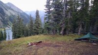
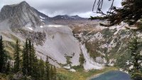
As you drop East of Trail Rider pass, there is a phenomenal campsite before you get to Snowmass Lake (see attached pics). If my memory is right, it was maybe half a mile above Snowmass Lake. It has some tree protection and amazing views to the lake below. Just look to the left of the trail as you descend and you'll see the use trail with the campsite basically right off the trail. There's no water there, so you'd need to pack in enough water to dry camp. This is why it's often available, though---people who don't know about it see the awesome campsite but aren't prepared water-wise, so they end up going all the way down to Snowmass Lake instead. Snowmass Lake is extremely crowded, but there are a lot of campsite opportunities in the area. You could also go a little past Snowmass Lake as if you're headed towards buckskin pass (maybe a mile from Snowmass Lake I think) and there are good camping opportunities in that area as well I think (I've never camped there personally though). That would add less than a mile of hiking to your trip. I have never been on the rest of your loop (down the Maroon Snowmass Trail and then the West Snowmass Trail), so I don't know about the campsite availability there either.

If you don't have a trail map for the area yet, I would recommend the Sky Terrain map instead of the Trails Illustrated map. It shows the user trail that I referred to before that will eliminate the walk to the Lead King road.

Also, there are a ton of cows along the Capitol Creek trail, so you'll want to get water further in (higher up) than the cows. Also, we came across a herd of around 200 sheep way up high (probably at 11k ft or so) right above a stream that we had just filtered from (and there was sheep manure all over on the other side of the stream, that we didn't see until after we had guzzled water and crossed the stream). My point being, you'll want to filter/purify water up there even if the streams look good.
 

Attachments

  • campsiteNight1.jpg
    campsiteNight1.jpg
    298.7 KB · Views: 229
  • campsiteNight1b.jpg
    campsiteNight1b.jpg
    293.1 KB · Views: 227
Similar threads
Thread starter Title Forum Replies Date
Joey Capitol Reef's Spring Canyon and Sulphur Creek loop from Holt Draw Backpacking 12
Dave Sulphur Creek, Capitol Reef Trip Planning 3
NateGeesaman Halls Creek Narrows of Capitol Reef July 2012 Backpacking 20
TrailScot Capitol Reef NP - Scenic Drive closure for several months General Discussion 0
TrailScot Golden Throne Circuit - Capitol Reef - October 2023 Hiking & Camping 5
TrailScot Capitol Reef NP - 5 Day Backpacking Adventure from Chimney Rock to Burro Wash - October 2023 Backpacking 10
WasatchWill Seeking Family History in Capitol Reef Backpacking 11
NorthwestWanderer 4 Days Backpacking Capitol Reef : Spring Canyon & Various side canyons Backpacking 5
Stephanie B Fishing (for Trout) and Hunting (for Rock Art) In and Near Capitol Reef National Park Hiking & Camping 7
IntrepidXJ Capitol Reef: Pilot Canyoneering Permit System General Discussion 0
Titans Prescribed burn South Monroe Mountain- photos from Capitol Reef area Photography 0
Stephanie B Capitol Reef National Park - First Real Visit Hiking & Camping 6
WasatchWill Backpacking Pleasant Pocket Mesa, Capitol Reef NP Backpacking 15
JulieKT Capitol Reef Temple of the Moon vandalism General Discussion 8
S Spring Canyon, Capitol Reef-vehicle shuttle Sun, Mar 24. Meet Up (Members Only) 0
WasatchWill Beehive Traverse - Through the Heart of Capitol Reef's Waterpocket Fold Backpacking 39
fossana Spring Canyon/Sulphur Canyon loop (Capitol Reef) Hiking & Camping 24
Jackson A Solo Stroll Near Capitol Reef Backpacking 17
Outdoors24 Overnight in Capitol Reef: A trip that ended early Backpacking 12
regehr Capitol Reef Star Party Trip Planning 0
J Capitol Reef Natl Park, Dayhikes March 29-April 2, 2018 Hiking & Camping 2
Nethos Capitol Reef/Escalante 2018 Trip Planning 11
Reef&Ruins Elf Slipper at Capitol Reef General Discussion 1
Ravialdo Capitol Reef in September? Trip Planning 3
WasatchWill Two trips in one at Capitol Reef Backpacking 12
Perry Capitol Reef NP - Navajo Knobs Trail Hiking & Camping 3
Perry Capitol Reef NP - Cassidy Arch from Cohab Canyon Trail Hiking & Camping 4
Perry Capitol Reef NP Hiking and Road Trip Suggestions Wanted Trip Planning 1
Parma Capitol Reef, Upper Muley Twist Day Hike Backpacking 19
J Dayhiking Capitol Reef Natl Park, Back to Utah! April 5-8, 2017 Hiking & Camping 4
M Capitol Reef backcountry recommendations? Trip Planning 9
Nick Cedar to Capitol Reef Hiking & Camping 11
Writhdar Waterpocket Canyon (Capitol Reef) non-technical access to upper part? General Discussion 1
WasatchWill Hiking Capitol Reef's Navajo Knobs Hiking & Camping 8
Seldom Seen Anderson Capitol Reef Ultras Trail Marking Hiking & Camping 2
CaptnKidd North End of Lake Powell and Southern Tip of Capitol Reef Hiking & Camping 11
IntrepidXJ Birthday Weekend in Capitol Reef Hiking & Camping 13
Jammer Rock the Park TV Series -- Capitol Reef General Discussion 6
Jammer Zion to Capitol Reef Hike Backpacking 21
uintahiker Fremont River Waterfall -Capitol Reef General Discussion 3
nsato311 Capitol Reef and Hanksville Trip Planning 3
WasatchWill Going Solo in Capitol Reef Backpacking 27
Jammer Zion to Capitol Reef Trip Planning 25
piper01 Southern UT in April: Cedar Mesa, Capitol Reef, GSENM Trip Planning 6
bscuderi capitol reef help Trip Planning 7
WasatchWill Invite Capitol Reef Loop: April 9 - 11 Meet Up (Members Only) 0
natylka Hiking 25 miles at Capitol reef for the weekend. Hiking & Camping 19
Ron Diel Nine Days in Capitol Reef Hiking & Camping 9
steve Where are your favorite primitive camping spots near Capitol Reef/Torrey? General Discussion 6
uintafly Capitol Reef in April Trip Planning 8

Similar threads

Back
Top