- Joined
- Aug 9, 2007
- Messages
- 12,967
April 2011
From the moment I first read Desert Solitaire, I knew I had to go to The Maze. It's a short chapter of that book and Abbey really just scratched the surface of what was out in this 'Terra Incognita'. A night at the Maze overlook followed by a pretty intense rappel/hike down into The Maze for the day before escaping back out before the clay surface of The Flint Trail became wet, potentially trapping them for days.
Not much has changed since then. Sure, the old trail register box has been swapped for a solar powered ranger station and there are a handful of rules and regulations to obey. But The Maze is still one of the most remote areas in the continental United States. It sits on the west side of the Green and Colorado Rivers. Easily within view of the many tourist-filled overlooks on the other side of the rivers but almost none of them will ever truly see it.
It may be hard to understand why it could be so difficult to reach. It is after all just 35 or so miles away from Moab, Utah. But to drive between the two points would require not only 8-10+ hours but also a very capable high clearance 4WD vehicle, a skilled driver and a level of self-sufficiency that few weekend warriors possess. A little dramatic? Maybe. I thought so before I went there, before my Tacoma had gotten some 'character' from rock crawling through Teapot Canyon. But once you're out there, it makes a lot more sense.
So after years of wishing, 2011 rolled around and I decided that I wasn't going to let another year roll by. I was going to The Maze. I didn't want to drive out there in one vehicle so my first order of business was to recruit at least one other person with a HC 4WD vehicle to go with. It worked out that some friends, Bill and Clint would drive down in Clint's Tacoma and I would drive mine along with my friends Nate and Taylor. I secured car camping permits for 4 nights in The Maze, 2 nights at Standing Rock and 2 nights at Doll House #3. The next 4 months would be filled with planning and anticipation like no trip I've ever planned before. In fact, I don't think I've ever put so much planning into any one thing in my life. How much water to bring? Backpacking gear, camping gear, extra gas tanks, tools, emergency supplies. Oh and a toilet. Gotta bring one of those too!
Okay, enough of the pre-trip report. We left Salt Lake on Wednesday afternoon, April 26th and made our way to Green River, UT where we topped off the gas tank and grabbed a sub for the road. From Green River we would be on nothing but dirt roads for the next 6 days. From Green River we went south onto the San Rafael Desert road towards Keg Knoll where we would meet up with Bill and Clint later that evening. The drive down the San Rafael Desert was fantastic. It had recently rained a lot so the colors were deep and contrasting. We followed a family of geese down the middle of the road and later came upon a small herd of Antelope before finally reaching our camp site at Keg Knoll just as the sun was setting.
This is Nate sitting out on the rocks by our site watching the glow roll over the desert and the distant La Sal mountains.

Clint and Bill arrived just before dark. We all spent the night enjoying the only campfire of our 6 day adventure. Naturally there were a few cameras setup around camp to record the experience.

Another star trail of our Keg Knoll camp. This one went for over an hour. The straight lines above the horizon are airplanes that flew through.

We didn't get to bed until close to 2am that night. Not good considering we were planning on getting up early to get over to the Hans Flat Ranger Station and into The Maze. Nate, Taylor and I slept out on the rock below camp. I don't usually sleep without a tent so it was a really nice way to kick off the trip.

Sunrise on Keg Knoll

On the way to Hans Flat we passed by the Horseshoe Canyon trailhead as well as the Granary Springs trailhead. Two points now famous thanks to the movie 127 Hours. Horsehoe Canyon TH is where Aron Raalston had left his car before mountain biking back to Granary Springs to descent Bluejohn Canyon. There has been quite the influx of people out looking for the 'blue pool' from the movie. Too bad the real blue pool is a hot spring up in Midway, Utah. Any pool you'd find in a slot canyon in Utah would be ice cold, brown and full of death and stink like you can't imagine. This sign was posted on an info board between the two trailheads.

We got to the Hans Flat Ranger Station around 8:45am. The ranger gave us all a chat about the rules and current conditions and then we were on our way.
We had to stop and check out the view down the Flint Trail before heading down it. There is no place to pass on the way down so the downhill traffic is supposed to check for cars first.

The view from The Flint Trail

A tight bend on The Flint Trail

After the Flint Trail we made our way out to the junction that leads to The Land of Standing Rocks. It's too bad there's not a road over by The Golden Stairs because this route basically makes you backtrack to the other side of Teapot Canyon which leads you to one of the most rugged off road experiences I've ever had. The roads near the junction on the other hand are nice and smooth. That's Clint blazing down the road towards Teapot Canyon.

Teapot begins with some easy but somewhat dramatic obstacles.


And then it gets nasty.


It took us a couple hours including a lunch stop to get through Teapot and on to The Land of Standing Rocks. Our camp for the night was at Standing Rock. We setup and went out exploring the rest of the day. We did a short hike to the canyon rims of The Maze to the north of camp first and then later that afternoon we hiked out to Sweet Alice Canyon to the south of camp to find an arch and get some views down into Ernie's Country and The Fins.
While looking for a route to Parachute Arch we stumbled across a nice little granary. Look closely in this photo and you can see it.

A closer shot of the Granary. We all walked right past this and Bill was just feet in front of it when he spotted it.

A tiny pothole arch on the way to Parachute Arch

Parachute Arch is huge but extremely hard to access and photograph. It's just on the other side of the bridge Nate is standing on.

Nate running across one of the spans of Parachute Arch. Hard to tell in this photo but each side of that span is pretty big drop.

A very large pothole arch about 100 feet away from Parachute Arch

The view of Standing Rock from the road on the way back to camp.

Sunset at Standing Rock. Hard to make people understand how big these rocks really are. This is from way back with my ultrawide lens just to get it all in the frame.

A night shot of our campsite at Standing Rock

The next day we packed up camp and drove to the Chimney Rock trailhead where we would begin our backpacking trip into the canyons of The Maze.

The route we took follows the ridge between Jasper Canyon and Pictograph Fork for several miles before dropping into the canyons below Pete's Mesa. It is an excellent hike with overwhelming views around every turn.

This is where the trail drops off the ridge and starts its way down into The Maze.

There's a bit of scrambling involved to get in and out of any of the canyons in The Maze. Lots of fun!

After a bit of climbing around we were finally down in The Maze

We went straight to a very nice campsite near the spring at the confluence of Pictograph Fork that a friend had recommended, Thanks Paul! Taylor, Nate and I hiked around the area and went up to see The Harvest Scene pictograph panel. It didn't look very good in direct sun. Meanwhile, Bill and Clint hiked up to the Maze Overlook. It was a windy and cold afternoon so we ended up chasing the sun around the canyon, trying to stay warm.

Nate and Taylor soaking in the last rays of the day.

Nice evening light near the confluence.

Pumping water from the spring near the Pictograph Fork confluence. Not a lot of water flowing here even after recent storms. I would usually not even filter spring water but this was just a seep.

That night was cold. Really cold. I went to bed super early because I was freezing. I hadn't brought enough layers for the temps. It had been pretty warm the night before so I just wasn't expecting it. The next day we packed up and moved into the sunshine to have breakfast. From there we hiked up Pictograph Fork, passing the Harvest Scene again but this time it wasn't in the sunshine. The difference was amazing. These figures are all life size. Click here to see a larger version of this image.


The wall that the Harvest Scene is on has several other small panels. This one is the furthest up canyon and we had missed it the previous night.

After a few miles of hiking up the canyon, the trail took us up a steep exit route back to the Canyon Rim at Chimney Rock.

This was the only spot that we felt compelled to take our packs off for. There was a stack of rocks below this dry fall that made it possible to climb over. It was pretty exposed.

One of the last scrambles. The canyon below is what we came up.

We spent a few minutes at Chimney Rock where Bill and Clint were waiting before heading down to the Dollhouse. I had it in my mind that the road to The Dollhouse would be a soft sandy joy ride. I was wrong.

Our campsite for the next two nights would be Dollhouse #3. There is no picture to adequately show how good the views are from here. One direction you see the Dollhouse formation, then the other you can see The Needles and the many grabens on the east side of the Colorado River. It's quite the site.

We lounged around camp for a while before heading over to The Dollhouse to hike around. At first I thought this graben was Surprise Valley but this one is much smaller.

The loop trail through The Dollhouse drops into this joint between some rocks. The entrance to it was barely wide enough for me and because of the rock on top barely tall enough.

The sun was angled perfectly to shine directly down the joint. It made for a very cool effect in there but very hard to photograph.

This is Surprise Valley as seen from the Granary Trail

4 out of the 5 granaries in the alcove at the end of the Granary Trail.

The road that heads back to Dollhouse #1 and #2 campsites.

The Dollhouse

Vertorama of The Dollhouse

Hiking back down the road from The Dollhouse to our campsite, Dollhouse #3

When we got back to camp we scrambled up to the rocks above camp where Clint and Bill were already taking pictures. The Dollhouse was glowing in the late light until just before we made it up but there were still some nice clouds around. The down side is that it was fffff-f-f-f-f-fffreeeezing cold up there! Like wind chill down towards 10 degrees I would imagine. But the views made it worthwhile.


After the sunset was done we climbed back down to camp where the wind would continue for the rest of the night. I ended up setting coolers and bins around my tent as a wind block to stay warm.
The next day we planned to do more hiking in The Dollhouse. Clint and Bill wanted to do the point-to-point from Shot Canyon to The Dollhouse via the Confluence Overlook. Nate, Taylor and I wanted to hear how the descent into Shot was first so we started on the other end of the loop unsure of whether our hike would be an out and back or a point-to-point. This shot is of the trail as it winds up through the Dollhouse.

Beehive Arch

Taylor checking out a little slot along the way.

A little more than half way to the overlook the trail goes through this area with lots of joints in the open slick rock. Cool stuff.

Taylor jumping a joint

The sand slog as the trail nears the Colorado River


Standing at this edge was AWESOME.

More joints in the rock. Some of these went way down.


We never actually saw the confluence of the Green and Colorado Rivers as the name of the trail would indicate. It's possible that its visible from somewhere further up but we didn't fully explore it. While we were there Bill and Clint showed up from hiking Shot and Water Canyon. We had already decided that we would do the point-to-point and hearing their description of the route only reinforced our desire to keep going. We all hung out at the edge of the canyon for a while and then moved on.
Bill and Clint heading off towards The Dollhouse

Meanwhile Taylor, Nate and I were making the sandy hike towards Water Canyon

Every canyon in The Maze has interesting ways to get in and out of it. Shot and Water were no exceptions. Notice Taylor and Nate on the left of this photo.

The hike into Water Canyon was down a fairly long tributary. Once we met the bottom of the canyon we were only there for a short distance before it climbed back out towards Shot Canyon. This shot is looking back down the slot that we used to get out of Water Canyon.

Hiking to the Pass between Water and Shot Canyons

Taylor and Nate looking into Shot Canyon from the Pass

And the view back into Water Canyon

The hike down into Shot Canyon was easy. The route followed the wash bottom for a while where we found numerous large pools of clean water from the recent rainstorms. After a while the trail rises up out of the washes and onto large flats.

As you approach the top of Shot Canyon it seems there is no way out anywhere. This shot is very near the beginning of the climb out.

Nearing the top of the canyon the route gets very interesting. This route was once used by ranchers to run cows into the canyon almost 100 years ago.

A very precarious set of stairs is built near the top.

Looking over at Nate and Taylor from the top of the stairs.

Nate looking back down into Shot Canyon from the rim


Almost back to Chimney Rock. Again.

That night the wind died down just as the sun went down. It was fantastic! It was the first night in a while that it was actually comfortable to sit outside. We spent a few hours around the candle lantern talking before heading off to bed.
The next morning we packed up quickly and started the drive out. I figured it would be about 8 hours at a brisk pace to get back to Salt Lake City. I'd heard it is a lot faster to go out through Hite and that's the exit point the park service had listed on our permit so that's the way we went. It took us 2 hours to get from Dollhouse #3 all the way through the Land of Standing Rocks and Teapot Canyon. That was a very fast pace. From there it took another 90 minutes or so of driving on the fast, smooth roads north of Hite before we were back to pavement on Highway 95, In total we traveled 175 miles on dirt roads from Green River to Hite, about 110 of those miles were getting from Green River to the Dollhouse.
The views along the road to Hite are excellent.

Here are some details of our planning that might help you out if you are planning a trip to The Maze.
I packed my Tacoma pretty heavy. There were three of us along with 28 gallons of water, 10 extra gallons of gas and all the food, drinks and camping gear to go with it. It turned out to be very cold for much of the trip so we ended up only using about 12 gallons of water. We actually ended up dumping some out for out drive back through Teapot Canyon.
On gas, I topped off my tank in Green River, Utah just a mile or two before hitting the dirt roads. By the time we reached the Dollhouse I had put on about 110 miles and I was down to about 3/8 tank. The night before we left I added the 10 gallons of gas that I had brought and it put me to just barely below a full tank. I was able to drive all the way to Hite and then up through Hanksville and onto Price, Utah before I had to fill up again. If I were to go out again I would still bring some extra gas but definitely no more than 5 gallons, YMMV.
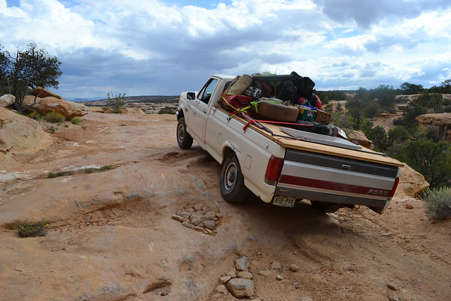
The road through Teapot Canyon is crazy bad. Don't get me wrong, I'm glad I did it. But I did some damage to my 2009 Tacoma in the process. Granted, my truck isn't lifted but it does have oversize BFG A/T tires on it that pick it up a bit. I scraped my chrome rear bumper on the bottom side a couple of times, squished my tail pipe a bit and had some HARD scrapes on the underside of the truck that I have yet to investigate. Clint's truck had a 2" lift and really big tires and from my point of view he probably had just as hard a time as I did. I think that one of the most important things to have for getting a regular HC 4WD vehicle through that canyon with minimal damage is to have a GOOD spotter that has lots of 4WD experience and can articulate what is happening outside the vehicle to the driver.
The next time I go to The Maze I probably won't drive all the way to The Land of Standing Rocks. Perhaps access from the Maze Overlook or Golden Stairs. Or maybe a jet boat ride to Spanish Bottom like a couple of backpackers we met along the confluence trail. One way or another, I'm going back and soon.
Campsites: I'll only comment on the sites beyond Teapot Canyon. The Wall looks like it would have awesome views but it's flat and wide open. Standing Rock is AWESOME and I would book it again in a heartbeat. Having that big rock to hide in the shade of would be a big benefit on a hot day and the views and proximity to the surrounding canyons are excellent. I would definitely not stay at Chimney Rock. The actual campsite is a flat patch of dirt well away from the rock itself and you'd have to stare at the cars parked at the trail head the whole time. Not ideal, especially if you're into taking pictures.
In the Dollhouse, site #3 is definitely tops as far as breathtaking panoramic views go but it is the only Dollhouse campsite not actually in the Dollhouse formation. I didn't visit #1 and #2 but others from our group did and they really liked them. They are much more sheltered and the views are more narrow but still very good. I think I would probably still go with #3 next time around because I like to be well away from other people and the rocks above #3 are such an incredible place to sit and see for miles. It is also a great hot weather site because the big rocks behind camp put the site in shade early in the evening and it gets sunrise as soon as the sun breaks the horizon.
I'll be posting some maps and GPS tracks shortly but if you have any questions or comments about this, please feel free to send me a message or use the comment form below.
From the moment I first read Desert Solitaire, I knew I had to go to The Maze. It's a short chapter of that book and Abbey really just scratched the surface of what was out in this 'Terra Incognita'. A night at the Maze overlook followed by a pretty intense rappel/hike down into The Maze for the day before escaping back out before the clay surface of The Flint Trail became wet, potentially trapping them for days.
Not much has changed since then. Sure, the old trail register box has been swapped for a solar powered ranger station and there are a handful of rules and regulations to obey. But The Maze is still one of the most remote areas in the continental United States. It sits on the west side of the Green and Colorado Rivers. Easily within view of the many tourist-filled overlooks on the other side of the rivers but almost none of them will ever truly see it.
It may be hard to understand why it could be so difficult to reach. It is after all just 35 or so miles away from Moab, Utah. But to drive between the two points would require not only 8-10+ hours but also a very capable high clearance 4WD vehicle, a skilled driver and a level of self-sufficiency that few weekend warriors possess. A little dramatic? Maybe. I thought so before I went there, before my Tacoma had gotten some 'character' from rock crawling through Teapot Canyon. But once you're out there, it makes a lot more sense.
So after years of wishing, 2011 rolled around and I decided that I wasn't going to let another year roll by. I was going to The Maze. I didn't want to drive out there in one vehicle so my first order of business was to recruit at least one other person with a HC 4WD vehicle to go with. It worked out that some friends, Bill and Clint would drive down in Clint's Tacoma and I would drive mine along with my friends Nate and Taylor. I secured car camping permits for 4 nights in The Maze, 2 nights at Standing Rock and 2 nights at Doll House #3. The next 4 months would be filled with planning and anticipation like no trip I've ever planned before. In fact, I don't think I've ever put so much planning into any one thing in my life. How much water to bring? Backpacking gear, camping gear, extra gas tanks, tools, emergency supplies. Oh and a toilet. Gotta bring one of those too!
Okay, enough of the pre-trip report. We left Salt Lake on Wednesday afternoon, April 26th and made our way to Green River, UT where we topped off the gas tank and grabbed a sub for the road. From Green River we would be on nothing but dirt roads for the next 6 days. From Green River we went south onto the San Rafael Desert road towards Keg Knoll where we would meet up with Bill and Clint later that evening. The drive down the San Rafael Desert was fantastic. It had recently rained a lot so the colors were deep and contrasting. We followed a family of geese down the middle of the road and later came upon a small herd of Antelope before finally reaching our camp site at Keg Knoll just as the sun was setting.
This is Nate sitting out on the rocks by our site watching the glow roll over the desert and the distant La Sal mountains.
Clint and Bill arrived just before dark. We all spent the night enjoying the only campfire of our 6 day adventure. Naturally there were a few cameras setup around camp to record the experience.
Another star trail of our Keg Knoll camp. This one went for over an hour. The straight lines above the horizon are airplanes that flew through.
We didn't get to bed until close to 2am that night. Not good considering we were planning on getting up early to get over to the Hans Flat Ranger Station and into The Maze. Nate, Taylor and I slept out on the rock below camp. I don't usually sleep without a tent so it was a really nice way to kick off the trip.
Sunrise on Keg Knoll
On the way to Hans Flat we passed by the Horseshoe Canyon trailhead as well as the Granary Springs trailhead. Two points now famous thanks to the movie 127 Hours. Horsehoe Canyon TH is where Aron Raalston had left his car before mountain biking back to Granary Springs to descent Bluejohn Canyon. There has been quite the influx of people out looking for the 'blue pool' from the movie. Too bad the real blue pool is a hot spring up in Midway, Utah. Any pool you'd find in a slot canyon in Utah would be ice cold, brown and full of death and stink like you can't imagine. This sign was posted on an info board between the two trailheads.
We got to the Hans Flat Ranger Station around 8:45am. The ranger gave us all a chat about the rules and current conditions and then we were on our way.
We had to stop and check out the view down the Flint Trail before heading down it. There is no place to pass on the way down so the downhill traffic is supposed to check for cars first.
The view from The Flint Trail
A tight bend on The Flint Trail
After the Flint Trail we made our way out to the junction that leads to The Land of Standing Rocks. It's too bad there's not a road over by The Golden Stairs because this route basically makes you backtrack to the other side of Teapot Canyon which leads you to one of the most rugged off road experiences I've ever had. The roads near the junction on the other hand are nice and smooth. That's Clint blazing down the road towards Teapot Canyon.
Teapot begins with some easy but somewhat dramatic obstacles.
And then it gets nasty.
It took us a couple hours including a lunch stop to get through Teapot and on to The Land of Standing Rocks. Our camp for the night was at Standing Rock. We setup and went out exploring the rest of the day. We did a short hike to the canyon rims of The Maze to the north of camp first and then later that afternoon we hiked out to Sweet Alice Canyon to the south of camp to find an arch and get some views down into Ernie's Country and The Fins.
While looking for a route to Parachute Arch we stumbled across a nice little granary. Look closely in this photo and you can see it.
A closer shot of the Granary. We all walked right past this and Bill was just feet in front of it when he spotted it.
A tiny pothole arch on the way to Parachute Arch
Parachute Arch is huge but extremely hard to access and photograph. It's just on the other side of the bridge Nate is standing on.
Nate running across one of the spans of Parachute Arch. Hard to tell in this photo but each side of that span is pretty big drop.
A very large pothole arch about 100 feet away from Parachute Arch
The view of Standing Rock from the road on the way back to camp.
Sunset at Standing Rock. Hard to make people understand how big these rocks really are. This is from way back with my ultrawide lens just to get it all in the frame.
A night shot of our campsite at Standing Rock
The next day we packed up camp and drove to the Chimney Rock trailhead where we would begin our backpacking trip into the canyons of The Maze.
The route we took follows the ridge between Jasper Canyon and Pictograph Fork for several miles before dropping into the canyons below Pete's Mesa. It is an excellent hike with overwhelming views around every turn.
This is where the trail drops off the ridge and starts its way down into The Maze.
There's a bit of scrambling involved to get in and out of any of the canyons in The Maze. Lots of fun!
After a bit of climbing around we were finally down in The Maze
We went straight to a very nice campsite near the spring at the confluence of Pictograph Fork that a friend had recommended, Thanks Paul! Taylor, Nate and I hiked around the area and went up to see The Harvest Scene pictograph panel. It didn't look very good in direct sun. Meanwhile, Bill and Clint hiked up to the Maze Overlook. It was a windy and cold afternoon so we ended up chasing the sun around the canyon, trying to stay warm.
Nate and Taylor soaking in the last rays of the day.
Nice evening light near the confluence.
Pumping water from the spring near the Pictograph Fork confluence. Not a lot of water flowing here even after recent storms. I would usually not even filter spring water but this was just a seep.
That night was cold. Really cold. I went to bed super early because I was freezing. I hadn't brought enough layers for the temps. It had been pretty warm the night before so I just wasn't expecting it. The next day we packed up and moved into the sunshine to have breakfast. From there we hiked up Pictograph Fork, passing the Harvest Scene again but this time it wasn't in the sunshine. The difference was amazing. These figures are all life size. Click here to see a larger version of this image.
The wall that the Harvest Scene is on has several other small panels. This one is the furthest up canyon and we had missed it the previous night.
After a few miles of hiking up the canyon, the trail took us up a steep exit route back to the Canyon Rim at Chimney Rock.
This was the only spot that we felt compelled to take our packs off for. There was a stack of rocks below this dry fall that made it possible to climb over. It was pretty exposed.
One of the last scrambles. The canyon below is what we came up.
We spent a few minutes at Chimney Rock where Bill and Clint were waiting before heading down to the Dollhouse. I had it in my mind that the road to The Dollhouse would be a soft sandy joy ride. I was wrong.
Our campsite for the next two nights would be Dollhouse #3. There is no picture to adequately show how good the views are from here. One direction you see the Dollhouse formation, then the other you can see The Needles and the many grabens on the east side of the Colorado River. It's quite the site.
We lounged around camp for a while before heading over to The Dollhouse to hike around. At first I thought this graben was Surprise Valley but this one is much smaller.
The loop trail through The Dollhouse drops into this joint between some rocks. The entrance to it was barely wide enough for me and because of the rock on top barely tall enough.
The sun was angled perfectly to shine directly down the joint. It made for a very cool effect in there but very hard to photograph.
This is Surprise Valley as seen from the Granary Trail
4 out of the 5 granaries in the alcove at the end of the Granary Trail.
The road that heads back to Dollhouse #1 and #2 campsites.
The Dollhouse
Vertorama of The Dollhouse
Hiking back down the road from The Dollhouse to our campsite, Dollhouse #3
When we got back to camp we scrambled up to the rocks above camp where Clint and Bill were already taking pictures. The Dollhouse was glowing in the late light until just before we made it up but there were still some nice clouds around. The down side is that it was fffff-f-f-f-f-fffreeeezing cold up there! Like wind chill down towards 10 degrees I would imagine. But the views made it worthwhile.
After the sunset was done we climbed back down to camp where the wind would continue for the rest of the night. I ended up setting coolers and bins around my tent as a wind block to stay warm.
The next day we planned to do more hiking in The Dollhouse. Clint and Bill wanted to do the point-to-point from Shot Canyon to The Dollhouse via the Confluence Overlook. Nate, Taylor and I wanted to hear how the descent into Shot was first so we started on the other end of the loop unsure of whether our hike would be an out and back or a point-to-point. This shot is of the trail as it winds up through the Dollhouse.
Beehive Arch
Taylor checking out a little slot along the way.
A little more than half way to the overlook the trail goes through this area with lots of joints in the open slick rock. Cool stuff.
Taylor jumping a joint
The sand slog as the trail nears the Colorado River
Standing at this edge was AWESOME.
More joints in the rock. Some of these went way down.
We never actually saw the confluence of the Green and Colorado Rivers as the name of the trail would indicate. It's possible that its visible from somewhere further up but we didn't fully explore it. While we were there Bill and Clint showed up from hiking Shot and Water Canyon. We had already decided that we would do the point-to-point and hearing their description of the route only reinforced our desire to keep going. We all hung out at the edge of the canyon for a while and then moved on.
Bill and Clint heading off towards The Dollhouse
Meanwhile Taylor, Nate and I were making the sandy hike towards Water Canyon
Every canyon in The Maze has interesting ways to get in and out of it. Shot and Water were no exceptions. Notice Taylor and Nate on the left of this photo.
The hike into Water Canyon was down a fairly long tributary. Once we met the bottom of the canyon we were only there for a short distance before it climbed back out towards Shot Canyon. This shot is looking back down the slot that we used to get out of Water Canyon.
Hiking to the Pass between Water and Shot Canyons
Taylor and Nate looking into Shot Canyon from the Pass
And the view back into Water Canyon
The hike down into Shot Canyon was easy. The route followed the wash bottom for a while where we found numerous large pools of clean water from the recent rainstorms. After a while the trail rises up out of the washes and onto large flats.
As you approach the top of Shot Canyon it seems there is no way out anywhere. This shot is very near the beginning of the climb out.
Nearing the top of the canyon the route gets very interesting. This route was once used by ranchers to run cows into the canyon almost 100 years ago.
A very precarious set of stairs is built near the top.
Looking over at Nate and Taylor from the top of the stairs.
Nate looking back down into Shot Canyon from the rim
Almost back to Chimney Rock. Again.
That night the wind died down just as the sun went down. It was fantastic! It was the first night in a while that it was actually comfortable to sit outside. We spent a few hours around the candle lantern talking before heading off to bed.
The next morning we packed up quickly and started the drive out. I figured it would be about 8 hours at a brisk pace to get back to Salt Lake City. I'd heard it is a lot faster to go out through Hite and that's the exit point the park service had listed on our permit so that's the way we went. It took us 2 hours to get from Dollhouse #3 all the way through the Land of Standing Rocks and Teapot Canyon. That was a very fast pace. From there it took another 90 minutes or so of driving on the fast, smooth roads north of Hite before we were back to pavement on Highway 95, In total we traveled 175 miles on dirt roads from Green River to Hite, about 110 of those miles were getting from Green River to the Dollhouse.
The views along the road to Hite are excellent.
Here are some details of our planning that might help you out if you are planning a trip to The Maze.
I packed my Tacoma pretty heavy. There were three of us along with 28 gallons of water, 10 extra gallons of gas and all the food, drinks and camping gear to go with it. It turned out to be very cold for much of the trip so we ended up only using about 12 gallons of water. We actually ended up dumping some out for out drive back through Teapot Canyon.
On gas, I topped off my tank in Green River, Utah just a mile or two before hitting the dirt roads. By the time we reached the Dollhouse I had put on about 110 miles and I was down to about 3/8 tank. The night before we left I added the 10 gallons of gas that I had brought and it put me to just barely below a full tank. I was able to drive all the way to Hite and then up through Hanksville and onto Price, Utah before I had to fill up again. If I were to go out again I would still bring some extra gas but definitely no more than 5 gallons, YMMV.
The road through Teapot Canyon is crazy bad. Don't get me wrong, I'm glad I did it. But I did some damage to my 2009 Tacoma in the process. Granted, my truck isn't lifted but it does have oversize BFG A/T tires on it that pick it up a bit. I scraped my chrome rear bumper on the bottom side a couple of times, squished my tail pipe a bit and had some HARD scrapes on the underside of the truck that I have yet to investigate. Clint's truck had a 2" lift and really big tires and from my point of view he probably had just as hard a time as I did. I think that one of the most important things to have for getting a regular HC 4WD vehicle through that canyon with minimal damage is to have a GOOD spotter that has lots of 4WD experience and can articulate what is happening outside the vehicle to the driver.
The next time I go to The Maze I probably won't drive all the way to The Land of Standing Rocks. Perhaps access from the Maze Overlook or Golden Stairs. Or maybe a jet boat ride to Spanish Bottom like a couple of backpackers we met along the confluence trail. One way or another, I'm going back and soon.
Campsites: I'll only comment on the sites beyond Teapot Canyon. The Wall looks like it would have awesome views but it's flat and wide open. Standing Rock is AWESOME and I would book it again in a heartbeat. Having that big rock to hide in the shade of would be a big benefit on a hot day and the views and proximity to the surrounding canyons are excellent. I would definitely not stay at Chimney Rock. The actual campsite is a flat patch of dirt well away from the rock itself and you'd have to stare at the cars parked at the trail head the whole time. Not ideal, especially if you're into taking pictures.
In the Dollhouse, site #3 is definitely tops as far as breathtaking panoramic views go but it is the only Dollhouse campsite not actually in the Dollhouse formation. I didn't visit #1 and #2 but others from our group did and they really liked them. They are much more sheltered and the views are more narrow but still very good. I think I would probably still go with #3 next time around because I like to be well away from other people and the rocks above #3 are such an incredible place to sit and see for miles. It is also a great hot weather site because the big rocks behind camp put the site in shade early in the evening and it gets sunrise as soon as the sun breaks the horizon.
I'll be posting some maps and GPS tracks shortly but if you have any questions or comments about this, please feel free to send me a message or use the comment form below.
")
")


