Vegan.Hiker
Member
- Joined
- Jul 5, 2014
- Messages
- 2,099
This is Part 4 of a four-part trip report covering a two-week backpacking and canoeing trip in April of 2016. I covered 134 miles on the trip, mostly in Canyonlands National Park. Of these 134 miles, 82 miles were spent backpacking and 52 miles were spent in a canoe. The first week of the trip was a solo backpack in the Needles. I then exited the desert to meet up with @Chuck the Mauler and two of his buddies from Michigan who joined me for the second week of the trip. After meeting up with them, we spent a night camping outside of Moab before kicking off week 2, which consisted of a 3-night river trip down the Colorado River from Potash to Spanish Bottom, followed by 4 days backpacking in the Maze.
The four reports are organized as follows:
Part 1 – From NYC to Elephant Canyon (Click HERE to view Part 1)
Part 2 – Chesler Park and Druid Arch (Click HERE to view Part 2)
Part 3 – Colorado River; Potash to Spanish Bottom (Click HERE to view Part 3)
Part 4 – The Maze District (Currently Viewing)
An extra big “thank you” to all of the BCP members who helped me plan this trip. Especially @Nick, @slc_dan and @Joey for patiently answering all of my questions (for literally months) and all the members who authored the dozens of Canyonlands trip reports I was able to pore through.
Part 4 – The Maze District
After spending the night at Spanish Bottom, our canoes were tied up and @Chuck the Mauler, Matt, Dave, and myself were ready to finally head up into the Maze where we would spend 4 days and 3 nights. We needed to be back here at Spanish Bottom in four days where a jet boat from Tex’s Riverways was scheduled to pick us up and shuttle us back to Potash, along with the canoes. While the river portion we had just completed was inspired by the Trip Reports of @gnwatts, the backpacking route through the Maze that we were about to begin was inspired by @Nick’s three-part series trip report which you can read HERE (Part 1), HERE (Part 2), and HERE (Part 3).
We pretty much took the same exact figure 8 route that was layed out in Nick’s trip report. The only minor differences between Nick’s route and ours was that we made a side trip out on the spur trail that overlooks the Colorado, we were thwarted by rain from climbing up to the top of the maze overlook, and we camped our third night at the Dollhouse site #3 instead of up on Jasper Ridge. The screen shot of our Gaia tracks below shows our exact route. Day 1 (red), Day 2 (yellow), Day 3 (blue), Day 4 (pink). @Joey was originally supposed to meet up with us for this section of the trip but he got in touch with us the week before I left and wouldn't be able to make it.

Day 1
We were the only people who spent the night at Spanish Bottom and we hadn’t seen anyone since arriving the day before. So as we were getting reading to begin our hike up to the Dollhouse, we were surprised to see a young girl near where our canoes were stashed. She was just going about her business, organizing her gear. We didn’t want to bother her, but we couldn’t figure out where the heck she had come from? There was no kayak or canoe, and no jetboat shuttles had come into Spanish Bottom during the entire time we had been there overnight. While the rest of the guys were packing up, I decided to take an early start up the 1,000 foot climb to the Dollhouse and wait at the top. The trail up to the dollhouse was well marked, provided easy footing, and gave some nice views of the Colorado along the way up. While waiting for the guys at the top, I ran into the young girl we had seen near our canoes and we chatted. She was from Washington but spent her summers in Utah as a river guide. She had backpacked the Needles and exited down Lower Red Lake Canyon and crossed the Colorado in $20 inflatable pool raft that she bought at Wal-Mart. She was heading into the Fins for a few days with a tarp to roll up in at night and some water. She looked like she was barely out of high school and maybe 110 pounds. I revered her toughness. People like that are a rare breed, regardless of gender.
The guys arrived shortly after and we headed north past Beehive Arch towards Water Canyon where we would spend the night near the spring. Along the way, we took a spur trail out to the Colorado River overlook. It was pretty awesome seeing the river from this vantage point, looking down, after having spent the past 3 days down on the river looking up. It was also cool to see the Needles from this vantage point. I remember talking to @Joey on the phone a few weeks before this trip and he told me it would trip me out to see the Needles from the Maze side after spending my first week in the Needles. He was totally right. When I was in the Needles, I had no sense that I was so high up above the river. It was also crazy that the Needles in Chesler Park looked so close (I could plainly see them), but I knew looking at the map, that they were a good 6 or 7 miles from the Colorado.
Matt looking around in the area of the Dollhouse.

The weather forecast was iffy and the cloud cover was thick at times, but I don’t recall it raining for more than a few minutes here and there and it never came down hard. It also turned out to be much cooler in the Maze than it was my first week in the Needles. A difference of about 15 degrees I think.

The view at the end of the spur trail out to the river overlook looking south. You can see the needles in Chesler Park on the left side of this photo.

Looking north up the Colorado. This is the direction we paddled in from.

@Chuck the Mauler getting a good view of the Needles across the river, a good 7+ miles away.

I ended up putting my camera away after the overlook and never got around to taking it back out, so I don’t have any pics of our campsite near Water Canyon. Basically, there was a wash that led down what I assume is normally a dryfall that falls into the spring below. Since there were pockets of rain in and around the area, there was water flowing down from the top. We topped off our water here and walked up the wash at the top of the dryfall until we found a campsite. There was a large alcove that probably would have fit all 4 of our tents, but there were 3 people occupying it already. They were the ones that let us know about the campsite a little further up the wash. After setting up camp, we found a rock overhang to sit under and cook dinner. Unfortunately, I never bothered taking my camera back out after the last bit of rain, so I don’t have any pictures of camp.
Day 2
Although the weather wasn’t terrible on Day 1, Day 2 brought better weather. For much of the day we had blue skies and I don’t think we had any rain that day. Our route for the day was to drop into Shot Canyon and then climb out of it near the Land of Standing Rocks. Once we made it to Chimney Rock, we walked the jeep road past Standing Rock and Lizard Rock. Once we made it to around the Plug, we dropped down into the Maze and hiked north past the Harvest Scene petroglyphs and camped at the bottom of the Maze Overlook. Does anyone know the name of the main canyon that we took from the Plug to the Harvest Scene? For some reason, none of the maps have it named and it was driving me crazy that I didn’t know what to refer to it as?
Climbing up and out of Water Canyon.

Shot Canyon started out really wide with low walls. It got narrower and deeper before the eventual climb out.

Here’s a view looking back into Shot Canyon after climbing out. I have no clue what is keeping those stone steps secured and whether they were put there by the park service or what?

When we finished climbing completely out of Shot Canyon there were awesome views in every direction. Here’s a shot of Matt taking a rest to take in the view.

From there we could see Chimney Rock and that was where we needed to head next, so navigating was easy at that point.

Matt, Dave and Chuck taking a break at Chimney Rock. Since this was about a 14 mile day, I needed to bust out the stove and cook my hot meal for the day. Backpackers Pantry Pad Thai… 920 calories woot woot!

We then headed down the jeep road to the Plug. We ran into the Park Rangers, a nice couple who nicely offered to top off our water for us, which we gladly accepted. We did have a little trouble locating the trail off of the jeep road near the plug, but we eventually found it after some backtracking.

We dropped into the canyon from this side canyon. At this point, the trail was very interpretive and my GPS showed we were pretty far off of the marked trail on the Nat Geo map.

While dropping into the canyon, you can see the Plug behind us. Looking back from this view in the picture below, it was kind of comical to think that we were wandering around the Plug up there and couldn’t find the canyon.

There were some interesting rock formations on the wall.

We knew going into this trip that Dave didn’t do well with exposure… Sorry Dave.

A few more pics of us dropping down.

Luckily, we were doing this while the rock was dry. This would be very dicey to descend when wet.

We finally made it to the bottom and it was much smoother going from down there.

Check out how small Chuck and Dave look in the picture below. You can barely see them.

We took a break at the Harvest Scene and took some time to take in the petroglyphs. Fascinating to see artwork so old and to pontificate about the meaning behind their depictions.

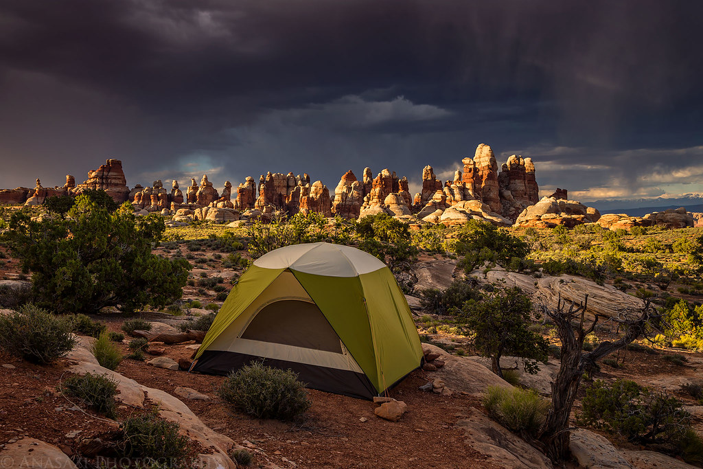
A few miles later, we made it to the spring near the bottom of the Maze Overlook. The spring was behind our tents in the picture below. Part of the chocolate drops can be seen right above us in the middle. The trail up to the Maze Overlook is to the right outside the frame. After a day of good weather, we could see that the clouds starting to roll in as we set up camp and ate dinner. Fortunately, the weather held up until we were already in our tents for the night.

Day 3
We woke up the next morning to the sounds of our tents getting pelted with rain. We waited for it to die down a little but ended up going down to the spring to restock our water supply in the rain. The plan was to leave our packs at camp and climb up to the top of the Maze Overlook before heading to Jasper Ridge. With the rain and slippery looking rock, we decided to pass on climbing up to the overlook after some debate.
We were fortunate that the rain had stopped as we did the climb out of the canyon up onto Jasper Ridge. Once we got up there and had a clear 360 degree view of the sky in all directions, we saw what we were dealing with. It was a total mixed bag; scattered, dark, stormy areas, but also areas of clear blue sky. As soon as we got onto Jasper Ridge, one of the dark, stormy spots was fast approaching. Chuck saw a rock overhang and suggested we wait it out. It was a great call. We sat dry under the overhang as the storm and some hail passed. About 40 minutes later we walked out into blue skies… until the next storm approached…
A view looking back at the Chocolate Drops after climbing up onto Jasper Ridge.

Waiting out the first storm under a rock overhang on Jasper Ridge.

The view from where we waited it out…

And this was the sky we walked out to about 40 minutes later.

Walking along Jasper Ridge, I believe this was looking down into Jasper Canyon.

With the wide open views on Jasper Ridge, we could see a second storm approaching with plenty of lead in time to find shelter. We waited out a second storm under another rock overhang. From this one you could see Standing Rock, Lizard Rock, and the Plug (barely visible since it’s in front of Lizard Rock).

Then about a half hour later, we stepped back out into the sunshine. But that wouldn’t be the end of it.

We crossed Chimney Rock again, which was the center landmark in our figure 8 route. We had debated camping between Jasper Ridge and Chimney Rock, but decided to keep moving. So once we got to Chimney Rock, we began the road walk back to the Dollhouse.
While walking along the jeep road, we encountered another storm. This time, we found two alcoves not far off of the jeep road. Matt and Dave took one alcove while Chuck and I took the one next door. I took out my stove and cooked dinner while the third and final storm of the day passed.

After the final storm passed, we finally got back to the Dollhouse.

At the Dollhouse, we ran into the same park rangers that we had met the day before. They told us that all three parties that had reserved the Dollhouse campsites had cancelled due to the weather. The rangers were camped in Site #1 but said that we were free to help ourselves to either site #2 or #3. We asked which was nicer and they said that hands down #3 was the nicest, so we began the half mile walk or so to campsite #3 instead of heading back down into Spanish Bottom.

Campsite #3 was an awesome spot. It was up on a hill overlooking the Dollhouse and had a clear view over the river to the Needles. When we got there, a nice rainbow could be seen from the view from the campsite.


The sky started to clear up as we set up and ate dinner, and I believe Chuck stayed up late to take some night shots after I passed out early.
What was really nice about this campsite was that all the tent areas were spread out. I set my tent up at this spot about 50 feet down a side trail and had a beautiful lookout of the Dollhouse and the sunrise in the morning.

Day 4
On our last day, we only had to hike a short 2 miles or so down to Spanish Bottom to catch our jetboat shuttle, so we had some time to drop our packs and do a short side trip to see Surprise Valley and the granary near the Dollhouse.


Matt and I noticed that if we were quiet and listened, you could hear rapids on the Colorado over on the other side of Surprise Valley. I don’t know if there are any trails down in Surprise Valley (I think I saw some faint ones looking down, but there were none on the map), but it looks like it would be a cool place to explore.


The granary, about half a mile from the Dollhouse.

They were tucked under this big rock.

Then it was time to make the final climb down towards the Colorado River.

A view of Spanish Bottom, the Colorado River, and Lower Red Lake Canyon (across the river) on the hike back down. That big tree on the bottom of the bend was our pickup point for our shuttle back from Tex’s Riverways.

From that point on, we had a cold, windy ride back to Potash, then Tex’s shuttled us by van back to our car in Moab. All in all, I think Tex’s runs a smooth operation and I wouldn’t hesitate to use them again or recommend them to anyone. From there we drove back to SLC, got rooms at the Best Western and went out for a hot dinner and some beers. The next morning, I said my goodbyes to the others in the airport as I had to go to a different terminal. I had another delay in Denver and made it back to Newark airport by around midnight. It was a great trip. Canyonlands is a special place. It worked out great having a week to solo backpack, and then it was great to have Chuck, Dave, and Matt with me on the second week. I really enjoyed their company and I have a feeling I’ll be backpacking with them again.
Thanks for reading,
John
The four reports are organized as follows:
Part 1 – From NYC to Elephant Canyon (Click HERE to view Part 1)
Part 2 – Chesler Park and Druid Arch (Click HERE to view Part 2)
Part 3 – Colorado River; Potash to Spanish Bottom (Click HERE to view Part 3)
Part 4 – The Maze District (Currently Viewing)
An extra big “thank you” to all of the BCP members who helped me plan this trip. Especially @Nick, @slc_dan and @Joey for patiently answering all of my questions (for literally months) and all the members who authored the dozens of Canyonlands trip reports I was able to pore through.
Part 4 – The Maze District
After spending the night at Spanish Bottom, our canoes were tied up and @Chuck the Mauler, Matt, Dave, and myself were ready to finally head up into the Maze where we would spend 4 days and 3 nights. We needed to be back here at Spanish Bottom in four days where a jet boat from Tex’s Riverways was scheduled to pick us up and shuttle us back to Potash, along with the canoes. While the river portion we had just completed was inspired by the Trip Reports of @gnwatts, the backpacking route through the Maze that we were about to begin was inspired by @Nick’s three-part series trip report which you can read HERE (Part 1), HERE (Part 2), and HERE (Part 3).
We pretty much took the same exact figure 8 route that was layed out in Nick’s trip report. The only minor differences between Nick’s route and ours was that we made a side trip out on the spur trail that overlooks the Colorado, we were thwarted by rain from climbing up to the top of the maze overlook, and we camped our third night at the Dollhouse site #3 instead of up on Jasper Ridge. The screen shot of our Gaia tracks below shows our exact route. Day 1 (red), Day 2 (yellow), Day 3 (blue), Day 4 (pink). @Joey was originally supposed to meet up with us for this section of the trip but he got in touch with us the week before I left and wouldn't be able to make it.
Day 1
We were the only people who spent the night at Spanish Bottom and we hadn’t seen anyone since arriving the day before. So as we were getting reading to begin our hike up to the Dollhouse, we were surprised to see a young girl near where our canoes were stashed. She was just going about her business, organizing her gear. We didn’t want to bother her, but we couldn’t figure out where the heck she had come from? There was no kayak or canoe, and no jetboat shuttles had come into Spanish Bottom during the entire time we had been there overnight. While the rest of the guys were packing up, I decided to take an early start up the 1,000 foot climb to the Dollhouse and wait at the top. The trail up to the dollhouse was well marked, provided easy footing, and gave some nice views of the Colorado along the way up. While waiting for the guys at the top, I ran into the young girl we had seen near our canoes and we chatted. She was from Washington but spent her summers in Utah as a river guide. She had backpacked the Needles and exited down Lower Red Lake Canyon and crossed the Colorado in $20 inflatable pool raft that she bought at Wal-Mart. She was heading into the Fins for a few days with a tarp to roll up in at night and some water. She looked like she was barely out of high school and maybe 110 pounds. I revered her toughness. People like that are a rare breed, regardless of gender.
The guys arrived shortly after and we headed north past Beehive Arch towards Water Canyon where we would spend the night near the spring. Along the way, we took a spur trail out to the Colorado River overlook. It was pretty awesome seeing the river from this vantage point, looking down, after having spent the past 3 days down on the river looking up. It was also cool to see the Needles from this vantage point. I remember talking to @Joey on the phone a few weeks before this trip and he told me it would trip me out to see the Needles from the Maze side after spending my first week in the Needles. He was totally right. When I was in the Needles, I had no sense that I was so high up above the river. It was also crazy that the Needles in Chesler Park looked so close (I could plainly see them), but I knew looking at the map, that they were a good 6 or 7 miles from the Colorado.
Matt looking around in the area of the Dollhouse.
The weather forecast was iffy and the cloud cover was thick at times, but I don’t recall it raining for more than a few minutes here and there and it never came down hard. It also turned out to be much cooler in the Maze than it was my first week in the Needles. A difference of about 15 degrees I think.
The view at the end of the spur trail out to the river overlook looking south. You can see the needles in Chesler Park on the left side of this photo.
Looking north up the Colorado. This is the direction we paddled in from.
@Chuck the Mauler getting a good view of the Needles across the river, a good 7+ miles away.
I ended up putting my camera away after the overlook and never got around to taking it back out, so I don’t have any pics of our campsite near Water Canyon. Basically, there was a wash that led down what I assume is normally a dryfall that falls into the spring below. Since there were pockets of rain in and around the area, there was water flowing down from the top. We topped off our water here and walked up the wash at the top of the dryfall until we found a campsite. There was a large alcove that probably would have fit all 4 of our tents, but there were 3 people occupying it already. They were the ones that let us know about the campsite a little further up the wash. After setting up camp, we found a rock overhang to sit under and cook dinner. Unfortunately, I never bothered taking my camera back out after the last bit of rain, so I don’t have any pictures of camp.
Day 2
Although the weather wasn’t terrible on Day 1, Day 2 brought better weather. For much of the day we had blue skies and I don’t think we had any rain that day. Our route for the day was to drop into Shot Canyon and then climb out of it near the Land of Standing Rocks. Once we made it to Chimney Rock, we walked the jeep road past Standing Rock and Lizard Rock. Once we made it to around the Plug, we dropped down into the Maze and hiked north past the Harvest Scene petroglyphs and camped at the bottom of the Maze Overlook. Does anyone know the name of the main canyon that we took from the Plug to the Harvest Scene? For some reason, none of the maps have it named and it was driving me crazy that I didn’t know what to refer to it as?
Climbing up and out of Water Canyon.
Shot Canyon started out really wide with low walls. It got narrower and deeper before the eventual climb out.
Here’s a view looking back into Shot Canyon after climbing out. I have no clue what is keeping those stone steps secured and whether they were put there by the park service or what?
When we finished climbing completely out of Shot Canyon there were awesome views in every direction. Here’s a shot of Matt taking a rest to take in the view.
From there we could see Chimney Rock and that was where we needed to head next, so navigating was easy at that point.
Matt, Dave and Chuck taking a break at Chimney Rock. Since this was about a 14 mile day, I needed to bust out the stove and cook my hot meal for the day. Backpackers Pantry Pad Thai… 920 calories woot woot!
We then headed down the jeep road to the Plug. We ran into the Park Rangers, a nice couple who nicely offered to top off our water for us, which we gladly accepted. We did have a little trouble locating the trail off of the jeep road near the plug, but we eventually found it after some backtracking.
We dropped into the canyon from this side canyon. At this point, the trail was very interpretive and my GPS showed we were pretty far off of the marked trail on the Nat Geo map.
While dropping into the canyon, you can see the Plug behind us. Looking back from this view in the picture below, it was kind of comical to think that we were wandering around the Plug up there and couldn’t find the canyon.
There were some interesting rock formations on the wall.
We knew going into this trip that Dave didn’t do well with exposure… Sorry Dave.
A few more pics of us dropping down.
Luckily, we were doing this while the rock was dry. This would be very dicey to descend when wet.
We finally made it to the bottom and it was much smoother going from down there.
Check out how small Chuck and Dave look in the picture below. You can barely see them.
We took a break at the Harvest Scene and took some time to take in the petroglyphs. Fascinating to see artwork so old and to pontificate about the meaning behind their depictions.
A few miles later, we made it to the spring near the bottom of the Maze Overlook. The spring was behind our tents in the picture below. Part of the chocolate drops can be seen right above us in the middle. The trail up to the Maze Overlook is to the right outside the frame. After a day of good weather, we could see that the clouds starting to roll in as we set up camp and ate dinner. Fortunately, the weather held up until we were already in our tents for the night.
Day 3
We woke up the next morning to the sounds of our tents getting pelted with rain. We waited for it to die down a little but ended up going down to the spring to restock our water supply in the rain. The plan was to leave our packs at camp and climb up to the top of the Maze Overlook before heading to Jasper Ridge. With the rain and slippery looking rock, we decided to pass on climbing up to the overlook after some debate.
We were fortunate that the rain had stopped as we did the climb out of the canyon up onto Jasper Ridge. Once we got up there and had a clear 360 degree view of the sky in all directions, we saw what we were dealing with. It was a total mixed bag; scattered, dark, stormy areas, but also areas of clear blue sky. As soon as we got onto Jasper Ridge, one of the dark, stormy spots was fast approaching. Chuck saw a rock overhang and suggested we wait it out. It was a great call. We sat dry under the overhang as the storm and some hail passed. About 40 minutes later we walked out into blue skies… until the next storm approached…
A view looking back at the Chocolate Drops after climbing up onto Jasper Ridge.
Waiting out the first storm under a rock overhang on Jasper Ridge.
The view from where we waited it out…
And this was the sky we walked out to about 40 minutes later.
Walking along Jasper Ridge, I believe this was looking down into Jasper Canyon.
With the wide open views on Jasper Ridge, we could see a second storm approaching with plenty of lead in time to find shelter. We waited out a second storm under another rock overhang. From this one you could see Standing Rock, Lizard Rock, and the Plug (barely visible since it’s in front of Lizard Rock).
Then about a half hour later, we stepped back out into the sunshine. But that wouldn’t be the end of it.
We crossed Chimney Rock again, which was the center landmark in our figure 8 route. We had debated camping between Jasper Ridge and Chimney Rock, but decided to keep moving. So once we got to Chimney Rock, we began the road walk back to the Dollhouse.
While walking along the jeep road, we encountered another storm. This time, we found two alcoves not far off of the jeep road. Matt and Dave took one alcove while Chuck and I took the one next door. I took out my stove and cooked dinner while the third and final storm of the day passed.
After the final storm passed, we finally got back to the Dollhouse.
At the Dollhouse, we ran into the same park rangers that we had met the day before. They told us that all three parties that had reserved the Dollhouse campsites had cancelled due to the weather. The rangers were camped in Site #1 but said that we were free to help ourselves to either site #2 or #3. We asked which was nicer and they said that hands down #3 was the nicest, so we began the half mile walk or so to campsite #3 instead of heading back down into Spanish Bottom.
Campsite #3 was an awesome spot. It was up on a hill overlooking the Dollhouse and had a clear view over the river to the Needles. When we got there, a nice rainbow could be seen from the view from the campsite.
The sky started to clear up as we set up and ate dinner, and I believe Chuck stayed up late to take some night shots after I passed out early.
What was really nice about this campsite was that all the tent areas were spread out. I set my tent up at this spot about 50 feet down a side trail and had a beautiful lookout of the Dollhouse and the sunrise in the morning.
Day 4
On our last day, we only had to hike a short 2 miles or so down to Spanish Bottom to catch our jetboat shuttle, so we had some time to drop our packs and do a short side trip to see Surprise Valley and the granary near the Dollhouse.
Matt and I noticed that if we were quiet and listened, you could hear rapids on the Colorado over on the other side of Surprise Valley. I don’t know if there are any trails down in Surprise Valley (I think I saw some faint ones looking down, but there were none on the map), but it looks like it would be a cool place to explore.
The granary, about half a mile from the Dollhouse.
They were tucked under this big rock.
Then it was time to make the final climb down towards the Colorado River.
A view of Spanish Bottom, the Colorado River, and Lower Red Lake Canyon (across the river) on the hike back down. That big tree on the bottom of the bend was our pickup point for our shuttle back from Tex’s Riverways.
From that point on, we had a cold, windy ride back to Potash, then Tex’s shuttled us by van back to our car in Moab. All in all, I think Tex’s runs a smooth operation and I wouldn’t hesitate to use them again or recommend them to anyone. From there we drove back to SLC, got rooms at the Best Western and went out for a hot dinner and some beers. The next morning, I said my goodbyes to the others in the airport as I had to go to a different terminal. I had another delay in Denver and made it back to Newark airport by around midnight. It was a great trip. Canyonlands is a special place. It worked out great having a week to solo backpack, and then it was great to have Chuck, Dave, and Matt with me on the second week. I really enjoyed their company and I have a feeling I’ll be backpacking with them again.
Thanks for reading,
John
Last edited:
")