- Joined
- Feb 23, 2012
- Messages
- 662
My spring didn't shape up like I'd hoped (lingering high ankle sprain, unplanned family events, etc.) So, my 3-week thru hike got downsized to a 9-day loop hike in the Burr Trail area. It was still a good outing despite the shorter itinerary (and lousy weather). Of course there's no reason for someone to repeat this route if they just want to see the highlights as most are accessible via day hikes. But... for me there’s a unique feeling/satisfaction gained from an extended hike. It’s hard to explain, but to me this was a perfect way to link together several great locations and achieve that unique sensation while wandering uninterrupted through the landscape.
The detailed day-by-day report with full gallery and interactive map can be found on my Across Utah post. I'll also post the hike video below or one can check it out on YouTube. Otherwise... the quick summary of the hike:
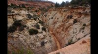
Setting out late morning on a chilly May 1st and down Big Horn Canyon:

Slot in Main Fork:

West Fork Slot:

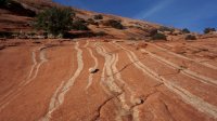
Colorful slickrock in the lower Big Horn Area:


I made camp a ways down Harris Wash. The next morning the sun came out. Though it was still chilly, I decided to do the side hike back to hit Tunnel and Zebra Slots. Tunnel first:

Not eager to get wet yet, I didn't go through the slot. Instead I went over the top to the pass and the "backdoor" route to Zebra. I enjoyed the slickrock and Moqui Marbles along the way.

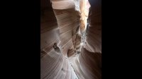
Arriving at Zebra I found it flooded as anticipated.

I dropped all but minimal gear and went in. "OMG how can this water be so cold?! " I almost turned back when it got up to my waist, but I talked myself into powering through. When the water was up to my chest I just keep saying "this is crazy, this is crazy, this is crazy." I was ready to swim, but luckily didn't need to. Soon I climbed out of the water and up into the dry final stretch of the canyon.


I didn't see the graffiti left by the jackhole couple earlier this year. There was a wall covered in brushed mud and I thought that was it, but in hindsight I don't think it's the same spot. Not sure if I missed it, or if the damage was successfully cleaned up.
Headed out of the slot was much faster as I knew what to expect and the water portion was now bathed in sunlight. But... it was still pretty darn cold!

Hiking down Harris Wash warmed me up. There's a nice stretch of entrenched canyon above the official TH and then farther down canyon it's classic Escalante. It seemed more brushy with more quicksand than I remember though.

At the river I headed downstream 4-5 miles to Choprock Canyon where I made camp and checked out the nearby petroglyphs. I love Choprock -- it's a great mix of entrenched streaked canyon walls, undercuts and narrows (and not many people.)


From the top of Choprock I headed cross-country towards Deer Point where I picked up an old mining road and enjoyed the great views from atop the bench where I walked right up on an Elk. We were mutually startled. Then about 30 minutes later I was startled again when I almost stepped on this guy:

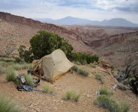
I made my way north along the Fold before dropping down toward the bottom of Lower Muley Twist. The incredibly steep descent is a leg burner. I ended up with a miserable camp on the steep slopes after I was too beat to make it all the way down before the end of the day. At least the views were awesome:

Finally down in Lower Muley Twist, the huge undercuts provided perfect shelter from the day's sporadic rain showers.


Made it just past the Burr Trail and near Peek-a-Boo Rock before calling it a day.

The next day I went up Upper Muley Twist enjoying all the arches and the upper slot before heading out the side canyon to the west and up to the Onion Beds where I was serenaded by a bunch of coyotes.


After following the back-roads for a while, I cut cross-country again through the rain to Upper Horse Canyon. I hoped to find some water here, but no luck despite the storm from the last few days
Day 8 started sunny...

... but turned to rain later in the day. This happened a lot this time out.
I originally planned to head northwest to the top of Egg Canyon and then down the canyon to the south to the Upper Gulch. However, with time/rations running low, I decided to connect with the Burr Trail and take it down Long Canyon.
I’m not a big fan of road-walking, but at least this is one of the most scenic roads around so it wasn’t miserable.

Down The Gulch I went and was happy that it didn't reek of cows like it did last time I hiked it. The rain started again as I made my way over to Sand Holler and then over the slickrock saddle to Boulder Creek where I made my final camp.

After wasting over an hour searching for a "shortcut" that supposedly bypassed a section of Boulder Creek, I retreated to the near the Narrows and then followed the creek all the way down. The water was kinda chilly, but luckily the sun was out and this was the warmest day of my trip.

At the Escalante I headed upstream for a few miles before turning on Phipps Canyon where I made the side hike up to the arch.

Late in the day I made my up upper Phipps Canyon where I got to watch a couple of eagles fighting with some swallows. Later, in the fading light I took my last look back at the amazing landscape.

Soon it was dark. A bit after that I was back to my Jeep and the loop was complete.")
9 days (4 w/o seeing another person) and 153 miles.

The detailed day-by-day report with full gallery and interactive map can be found on my Across Utah post. I'll also post the hike video below or one can check it out on YouTube. Otherwise... the quick summary of the hike:
Setting out late morning on a chilly May 1st and down Big Horn Canyon:
Slot in Main Fork:
West Fork Slot:
Colorful slickrock in the lower Big Horn Area:
I made camp a ways down Harris Wash. The next morning the sun came out. Though it was still chilly, I decided to do the side hike back to hit Tunnel and Zebra Slots. Tunnel first:
Not eager to get wet yet, I didn't go through the slot. Instead I went over the top to the pass and the "backdoor" route to Zebra. I enjoyed the slickrock and Moqui Marbles along the way.
Arriving at Zebra I found it flooded as anticipated.
I dropped all but minimal gear and went in. "OMG how can this water be so cold?! " I almost turned back when it got up to my waist, but I talked myself into powering through. When the water was up to my chest I just keep saying "this is crazy, this is crazy, this is crazy." I was ready to swim, but luckily didn't need to. Soon I climbed out of the water and up into the dry final stretch of the canyon.
I didn't see the graffiti left by the jackhole couple earlier this year. There was a wall covered in brushed mud and I thought that was it, but in hindsight I don't think it's the same spot. Not sure if I missed it, or if the damage was successfully cleaned up.
Headed out of the slot was much faster as I knew what to expect and the water portion was now bathed in sunlight. But... it was still pretty darn cold!
Hiking down Harris Wash warmed me up. There's a nice stretch of entrenched canyon above the official TH and then farther down canyon it's classic Escalante. It seemed more brushy with more quicksand than I remember though.
At the river I headed downstream 4-5 miles to Choprock Canyon where I made camp and checked out the nearby petroglyphs. I love Choprock -- it's a great mix of entrenched streaked canyon walls, undercuts and narrows (and not many people.)
From the top of Choprock I headed cross-country towards Deer Point where I picked up an old mining road and enjoyed the great views from atop the bench where I walked right up on an Elk. We were mutually startled. Then about 30 minutes later I was startled again when I almost stepped on this guy:
I made my way north along the Fold before dropping down toward the bottom of Lower Muley Twist. The incredibly steep descent is a leg burner. I ended up with a miserable camp on the steep slopes after I was too beat to make it all the way down before the end of the day. At least the views were awesome:
Finally down in Lower Muley Twist, the huge undercuts provided perfect shelter from the day's sporadic rain showers.
Made it just past the Burr Trail and near Peek-a-Boo Rock before calling it a day.
The next day I went up Upper Muley Twist enjoying all the arches and the upper slot before heading out the side canyon to the west and up to the Onion Beds where I was serenaded by a bunch of coyotes.
After following the back-roads for a while, I cut cross-country again through the rain to Upper Horse Canyon. I hoped to find some water here, but no luck despite the storm from the last few days
Day 8 started sunny...
... but turned to rain later in the day. This happened a lot this time out.
I originally planned to head northwest to the top of Egg Canyon and then down the canyon to the south to the Upper Gulch. However, with time/rations running low, I decided to connect with the Burr Trail and take it down Long Canyon.
I’m not a big fan of road-walking, but at least this is one of the most scenic roads around so it wasn’t miserable.
Down The Gulch I went and was happy that it didn't reek of cows like it did last time I hiked it. The rain started again as I made my way over to Sand Holler and then over the slickrock saddle to Boulder Creek where I made my final camp.
After wasting over an hour searching for a "shortcut" that supposedly bypassed a section of Boulder Creek, I retreated to the near the Narrows and then followed the creek all the way down. The water was kinda chilly, but luckily the sun was out and this was the warmest day of my trip.
At the Escalante I headed upstream for a few miles before turning on Phipps Canyon where I made the side hike up to the arch.
Late in the day I made my up upper Phipps Canyon where I got to watch a couple of eagles fighting with some swallows. Later, in the fading light I took my last look back at the amazing landscape.
Soon it was dark. A bit after that I was back to my Jeep and the loop was complete.
9 days (4 w/o seeing another person) and 153 miles.
Attachments
Last edited:
