fossana
Member
- Joined
- Jan 11, 2018
- Messages
- 1,038
Intro
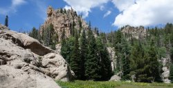
The monsoonal forecast was putting a damper on my plan A efforts to get acclimatized. Fortunately, I had another option in my extended backyard, the Pine Valley Mountains. While the area isn't quite as scenic as I would prefer, the steep and shady trails with elevations up to 10K feet provide great mid-summer training. Although I live much closer to the southern side of the range, I hadn't explored much of the Pine Valley (northern) side of the range, so I picked a loop out of Pine Valley.
Logistics
Jurisdiction: wilderness (part of Dixie National Forest)
Permits/fee: no permits required even if overnighting; possible day use fee for the Pine Valley recreation area (not consistently enforced)
Dogs friendly: yes
Water: Some seasonal streams along the way. Warning: the water tasted off in the stream near the Whipple/Summit junction (recommend avoiding).
Start/end: Brown Point trailhead or Whipple trailhead
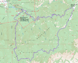
Mileage: 17.7 per National Geographic map (walked road to close the loop versus the trail)
Elevation gain: ~5.2K ft
Navigation: For the most part the trail and most junctions were signed; however, the trail was inapparent at times during some meadow crossings. The Whipple trail junction was easy to miss.
Map
References
National Geographic's St George, Pine Valley Mountains map
Photos
