Bowknot Bend saddle, hike up from south side??

Kullaberg63

Member
Joined
Mar 6, 2014
Messages
602
I know there's a trail up from the river on the north side (done it), but can you ascend/descend from the south side? I'm planning a packraft dayhike for this coming weekend that hinges on this crucial piece of info. Thanks!
 
I don't know, but I just checked my photos from when I drifted by there last October. Usually I take a lot of photos of a thing like that, but curiously I only took one. Click here to view it in super high resolution or see smaller version below. It doesn't look like any way up in that frame but it's super close to going in a few spots so there definitely might be a way. Hopefully someone else can be more definitive, but I thought I'd post anyway.

Super high res version: http://backcountrypost.com/forum/uploads/bowknot.jpg

IMG_0317.jpg

Perhaps @Udink @ashergrey or @gnwatts know more...
 
It took me a while to remember where I'd read an account of a southerly route down from the saddle. This is from Steve Allen's Utah's Canyon Country Place Names:

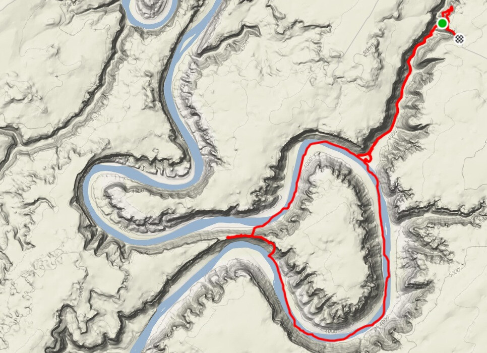
Hiking Trail: A short trail leads up the north side of the neck of Bowknot Bend where the BLM has placed a visitor register. It is easy to hike to the saddle on the trail from the north side, but is it difficult to go down the other side as Raymond Austin Cogswell found in 1909: "Climbed down on S. side. Had a hard pull of it; had to run a long way to W. to get a chance to climb off ledge. Got a little way down; had to squeeze down a crevice and pull camera after. Risky if should lose hold."

Devergne Barber of the 1927 Pathe-Bray Expedition also had a problem going down: "Unfortunately we had brought no ropes along... Half way down we rimmed up... After many attempts, in which the nerve of every man was tested, by crawling on our hands and knees under an overhanging ledge, and then hanging by our hands and dropping about 12 feet, we found a place where descent to the river was possible... Incidentally, in making this drop it was necessary to fall flat on one's back for the shelf on which we fell was but a few feet wide and was followed by a sheer drop of 200 ft.

I doubt that constitutes "fair use," so feel free to remove this, Nick, before Google indexes it. :D
 
This is just from looking at sat view, but I'd bet money that this route goes, if not something better.

View attachment 16131
It looks like staying high either east or west will eventually let you drop below the cliff band and go down the talus, but I think west is the shortest distance before finding a break in the cliffs.

I dunno man, that makes me want to buy that book even more....
I've never regretted the purchase. :)
 
It looks like staying high either east or west will eventually let you drop below the cliff band and go down the talus, but I think west is the shortest distance before finding a break in the cliffs.

I agree, the west looks good too, but if it were the only way that looked good on sat, I'd be a little apprehensive. The east route looks like a sure thing, IMO.
 
Some dramatic reports by those old explorers, for sure. We'll likely give it a shot, although after finding udink's report of his geocache hunt to the top I'd def have to go there too!
 
From the saddle looking east along the south slope:
_MG_9914.jpg
From the water looking at the eastern side of the south slope:
_MG_9963.jpg
From the water looking at the western side of the south slope:
_MG_9981.jpg
 

Similar threads

Back
Top