Boulder Mail Trail - end of October?

Joined
Mar 18, 2014
Messages
111
I know this weather honeymoon we're experiencing of warmer temps will probably not last through the end of October. But let's just say it does, and I have a long weekend at the end of the month to fit in a bucket list hike I've always wanted to do, I was thinking about this trail because I have a friend in SLC that could meet up with me and run a car shuttle. Anyone have experience doing this trail at this time of the year and can give me a heads up with what to expect? I've never really been able to pin point the best time of year for this trail with weather and water from the trips that I've looked into. Thanks in advance for any advice you can give.
 
I haven't done the full length, but you'll absolutely have water in Sand Creek and Death Hollow, so as long as you're willing to carry some, that would get you through just fine. You may have some potholes closer to Escalante as well, but I'm not certain.

And be prepared for possible cold. I'd definitely do it in late October though, if it were me.
 
I did it in January one year. Late October will be idyllic. There's a spring at the top of the trail on the east side of Death Hollow as well.
 
Don't count on water in Mamie Creek. We found one small stagnant pothole last month, filter clogger. Springtime there's no issue up there, at least in my experience, every time I've been up there the potholes were full.
The smaller canyons you cross after Antone Flat on the Escalante side had plenty of water.
The poison ivy was epic in DH. Should be a non issue by then,
 
Mamie creek had a hugh pour off pool up at the head......used to have fish... Has that dried up?
 
Mamie creek had a hugh pour off pool up at the head.....used to have fish... Has that dried up?

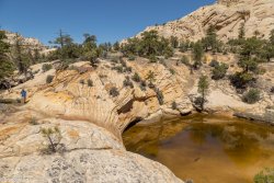
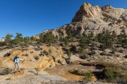
We hiked a quarter mile up Mamie from where the BMT comes in, dry up there. The biggest pothole I can remember is this one...where the trail meets the creek...

May 2015
IMG_1225.jpg


September 2020
2A4A0634.JPG
 
Thank you for all the advice! Is there a map or guidebook that I can buy for this area that would help lay all of this out to ponder over? Or a favorite detailed trip report? I have bookmarked so many over the years when seeing this place. I feel like I need a good map of the area and then I can start piecing together trail names and distances into something manageable. With 2.5 days and a car shuttle we should be able to cover a good deal of the area?
 
Thank you for all the advice! Is there a map or guidebook that I can buy for this area that would help lay all of this out to ponder over? Or a favorite detailed trip report? I have bookmarked so many over the years when seeing this place. I feel like I need a good map of the area and then I can start piecing together trail names and distances into something manageable. With 2.5 days and a car shuttle we should be able to cover a good deal of the area?

Or do I just follow this?
https://www.alltrails.com/explore/t...=sidebar-static-map&ref=sidebar-view-full-map
 
You aren't going to be doing any sustained wading for the BMT proper and quite a bit of the route is exposed to the sun. Finding water is going to be crux this year unless we get some productive storms. If you're starting at the upper trailhead and have water concerns, I would consider finishing on lower Death Hollow instead of the BMT proper. IMO it's more scenic. Death Hollow still had plenty of water as of a few weeks ago. I hiked lower Death Hollow in early Nov in 2017. It was fine with neoprene socks. Given the current temp outlook, this year is unlikely to be any different comfort-wise.

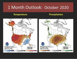
Here's
the fall/early winter Great Basin forecast. Excerpt:

Screen Shot 2020-10-11 at 10.54.41 AM.png
 
THanks all. The plan was to start with the BMT and go down Death Hollow to Escalante River and then out. 2.5-3 days. Does that seem doable and we'll be able to find water?
 
THanks all. The plan was to start with the BMT and go down Death Hollow to Escalante River and then out. 2.5-3 days. Does that seem doable and we'll be able to find water?

Assuming you mean going down the Escalante to the Hwy 12 bridge.
You will have water at Sand Creek if you start at the airport, then once you drop into DH, walking in water will be the main crux, not finding it. I second the neoprene socks, and with sunlight at a premium expect some long cold evenings and chilly mornings. I have been in early October and end of February.

It's beautiful down there.
 
Bit of random data... I was just in the Escalante area last weekend. Boulder Creek is bone dry down to where Dry Hollow dumps some water into it. Deer Creek has plenty of flow. The big slickrock zone east of Deer Creek and south of the Burr Trail has plenty of potholes containing some water, surprisingly.

On the way out last Sat we had thought to grab some food at Hells Backbone Grill but there were like 60 cars parked there, never seen anything like it.

Saturday was the marathon which probably contributed some? Hells Backbone Grill was still busy Sunday too when we went by, we grabbed a bite at Magnolias instead.
 
Tourism has just skyrocketed in the area very recently. Like all over southern Utah. It's been busier in the past month than in the same timeframes during the last several years. Kinda nuts. Spring was dead quiet due to shutdown, and this fall has totally exploded with folks visiting. People just trying to escape from cities and get out into the wild and all that. Hell's Backbone has been extra busy because of that, especially on the weekends, and also because they haven't been doing reservations this year, and they only have outdoor seating. Also they're only open for dinner this year. So people have to just show up to try to get a seat. They're only open through the end of October this year. But I still really recommend them. Such amazingly delicious food.
 
Hells Backbone Grill is worth the wait. Always.
 
Similar threads
Thread starter Title Forum Replies Date
TrailScot Escalante Loop via Dry Hollow and Boulder Mail Trail - September 2023 Backpacking 8
L Boulder Mail Trail April 2023 Qs Trip Planning 14
R Boulder Mail Trail to Death Hollow Trip Planning 1
Brett Boulder Mail Trail - April 26-27, 2019 Backpacking 2
cmgz Boulder Mail Trail - Escalante Trailhead to Mamie Creek Hiking & Camping 1
Brett Boulder Mail Trail - Logistical Qs Trip Planning 10
Janice Loop possible with Boulder Mail Trail? Noobs: Introduce yourself! 8
Ugly In and Out - Boulder Mail Trail to DH Backpacking 9
Jackson Death Hollow from the Boulder Mail Trail Backpacking 18
Skiwi Boulder Mail Trail to Death Hollow questions Trip Planning 8
Nick Boulder Mail Trail Backpacking 10
mattvogt7 Boulder Mail Trail, Jan 2014 Backpacking 13
Nick Boulder Mail Trail in winter General Discussion 37
John Mckean Boulder Mail Trail to Highway 12 Backpacking 6
John Mckean Boulder mail trail to Hwy 12 bridge question General Discussion 6
J Boulder Mail Trail Question General Discussion 2
Tyler Boulder Mail trail to Sand Creek March 2012 Backpacking 3
Nick Death Hollow & The Boulder Mail Trail Backpacking 23
Titans Boulder Mtn snow March 29- 2023 Photography 1
M Hollow Boulder Trip Planning 1
John Goering Boulder Lakes, Tobacco Root Mountains Off Road 0
RSchott Hello from Boulder, CO Noobs: Introduce yourself! 0
swmalone Restaurant Suggestions for Escalante or Boulder General Discussion 11
LarryBoy Five Days on Boulder Mountain Backpacking 5
Udink Boulder Top Hiking & Camping 4
ramblinman Boulder Creek Day Hike, Escalante National Monument Hiking & Camping 5
WasatchWill To the Boulder Top Backpacking 9
Parma Idaho's White Cloud Mountains - Boulder Chain Lakes - Chamberlain Basin Backpacking 8
J Who's done Steep Creek Canyon off Boulder Mtn folows into the Gulch at the Burr Trail? Trip Planning 3
3DegreesSouth Paria/Buckskin Boulder Jam Trip Planning 6
ramblinman Food Fight: Article in the New Yorker about the Hell's Backbone Grill in Boulder, UT General Discussion 7
msteudel Boulder Mountain North Slope UT: Donkey Res. to Lost Lake? Trip Planning 1
wesleyS Road from Boulder airstrip, UT Hiking & Camping 5
Perry Spring Day Hike up Boulder Creek Hiking & Camping 2
S White Cloud route, Big Boulder Lakes to Boulder Chain Lakes Trip Planning 3
M VIDEO - Bear Peak, Boulder, Colorado General Discussion 0
Bob Morris Glacier in 2 Weeks!!! (Boulder Pass Questions) Trip Planning 10
Jammer Boulder Creek NON Short-cut General Discussion 15
John Goering South Boulder River (Tobacco Root Mountains) day hikes. Hiking & Camping 8
muir_mountain Walker Ranch Loop, Boulder, CO Hiking & Camping 3
Jimmy Glacier Natl Park - Boulder Pass Trail Trip Planning 36
lostlandscapes Big Boulder Lakes, White Clouds -- July 3-5, 2015 Backpacking 12
Nico Boulder Mountain Trip Planning 19
Duke Which Lakes on the Boulder have no vehicle access General Discussion 7
steve Thanksgiving: Capitol Reef to Boulder Mountain Off Road 5
Jammer Boulder Mountain → Moab Hike Backpacking 14
Laura Aspen on Boulder Mountain Trip Planning 5
Nick Boulder Creek, Escalante Backpacking 34
Jammer Boulder to Moab Hike Video Backpacking 22
BJett Boulder Creek Backpacking 18

Similar threads

Back
Top