Boulder Creek NON Short-cut

Jammer

❤2Hike
.
Joined
Feb 23, 2012
Messages
644
If you watched my recent video from 9-day loop hike, you saw that at one point I got cliffed out while trying to short-cut past a portion of Boulder Creek. As I mentioned in the video, I cannot recall WHERE I saw this short-cut noted though I clearly remember how/where the short-cut was drawn on the map. I think it merely said 'bypass' and I remember thinking "Hmm... I wonder if they are confusing that with the bypass of the narrows to the north?" Now I'm going through all my source material and I cannot find anything which has it documented as I remember. I thought maybe is was on the TOPOs at the Escalante visitor center, but I checked there after my hike and it had no such notes (unless they have multiple maps?)

Anybody else ever seen mention of this? I'd love to know that I'm not losing my mind! :) I know about the route Allen discusses which goes higher and then down to the Escalante, but that's not what I'm talking about.

Here's my re-creation of how the supposed short-cut was noted (red double arrow):
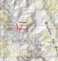
BoulderCreekMap.jpg
 

Michael

Alien from over the pond...
Joined
Sep 5, 2012
Messages
1,037
@Jammer
1. Your trip report and the video are excellent. Great stuff for our next seasons.

2. You haven't lost your mind. :)

There is a bypass southeast of the 20' drop in the end of the next big bend of Boulder Crk.

BUT I never has taken this one. April was not the right time for us to play in the water of Boulder Crk.

From the Lower Gulch TH we took Allen's overland route to a spring north of Sleepy Hollow than via Hansen Cabin towards Escalante River and back to the Gulch via Brigham Tee Bench and out.

From the corner Hansen/Escalante River, a half mile upriver is a connection to Spencer Flat Rd.


Gesendet via iPhone 6S mit TapaTalk
 

Joey

walking somewhere
Joined
Apr 1, 2014
Messages
878
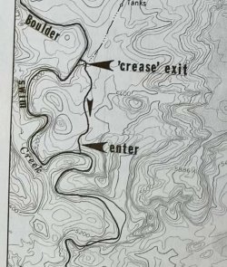
I'm kind of confused by you referring to 2 different short cuts. So sorry if this is not what your talking about. But I recognize that map as the short cut of the narrows. Allen has a route drawn that looks just almost exactly like your recreated map. Map 40, page 264 in Canyoneering 3. But the narrows are different from where you draw them on your map. I've dropped down right into Boulder Creek from where you have the word Narrows written. And I don't recall a 20 foot drop being mentioned. Twice i've by passed the section of canyon similar to your map, but not the section you have drawn as narrows.

Its thrown me for a loop both times. If you're hiking up canyon, the route out to by pass the narrows is between the words "swim" and "creek" on Allen's map. Pretty close to the letter c in "creek" I believe. Haven't had a chance to watch your video yet to see what you did (real slow internet right now), but look forward to checking it out to see your route.
 

Jammer

❤2Hike
.
Joined
Feb 23, 2012
Messages
644
Allen has a route drawn that looks just almost exactly like your recreated map. Map 40, page 264 in Canyoneering 3. But the narrows are different from where you draw them on your map.

OMG -- that's it! Somehow I missed that page when I went back through my books. I can say with 99% certainty that the route is not possible as he describes/shows (the spot marked "Enter" would be a crazy climb at best). His text is even in error "a trail down a draw leads back to Deer Creek". It's Boulder Creek at this point and even he states as such on the prior page "Below the confluence of Deer and Boulder creeks the united canyons are called Boulder Creek."

I'm going to scan this and then post in more detail soon with some reference shots.

THANKS!
 

Joey

walking somewhere
Joined
Apr 1, 2014
Messages
878
OMG -- that's it! Somehow I missed that page when I went back through my books. I can say with 99% certainty that the route is not possible as he describes/shows (the spot marked "Enter" would be a crazy climb at best). His text is even in error "a trail down a draw leads back to Deer Creek". It's Boulder Creek at this point and even he states as such on the prior page "Below the confluence of Deer and Boulder creeks the united canyons are called Boulder Creek."

I'm going to scan this and then post in more detail soon with some reference shots.

THANKS!

Glad that helped.
Where you coming down or going up Boulder Creek? I don't think i've used either his entrance or exit spots on that by-pass.
I've yet to go down those narrows. I want to bring a tube down there and spend a day tubing down it a few times.
 

Jammer

❤2Hike
.
Joined
Feb 23, 2012
Messages
644
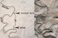
OK... below is the Allen map which I believe is in error or involves some incredibly steep slickrock. As Joey noted, it's from the Canyoneering 3 guidebook. Google SAT imagery on the right for reference:

Allen_Route_and_SAT.jpg


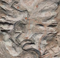
Here is the SAT image marked up with location tags for notes/pics below:

BoulderCreekNarrows.jpg


The center orange line is the bypass in question. The other orange line to the right is his route from Canyoneering 2 which leads down one bend farther south (and then continues back up through a slot.)

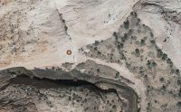
Closer on the area around Location #2 where Allen suggests to re-enter Boulder Creek:

Detail.jpg


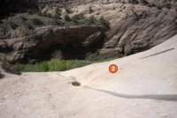
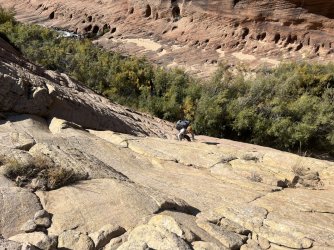
I made my way down the very steep slickrock to spot #2 which sits on a bench before rounding off into a cliff around the entire bend:

OnTop.jpg


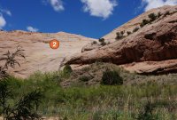
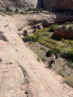
Hesitant to believe that Allen is flat-out 'wrong', my guess is that he went straight down/up the drainage. I looked at this and chickened out before I could even see the route all the way down:

OnTop2.jpg


The same spot from below:

TheRealRoute.jpg


Definitely doesn't seem doable to me. I checked the wall all the way down and it was cliffed out the whole way.

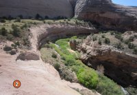
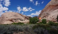
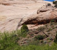
As noted above, according to Canyoneering 2 there is a route back down to the creek one bend to the south. I didn't see this spot either, but I didn't look too closely as I was short-cutting the bend on the opposite side. Here's a shot of the area though and I suspect a way down might be hidden by that tree near the center:

LowerBend.jpg


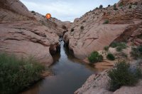
Both times through the area I entered/exited via the pass leading to The Gulch (marker #5). When I did do the loop through the narrows, I had to walk up to about marker #4 where I found a spot to do a controlled slide down a 8' slickrock face to reach the bank of the creek. I remember thinking that it might be really hard to reverse if necessary. Luckily I didn't have to. Some shots from the narrows:

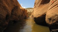
Looking down out the bottom of the narrows:

Narrows_Inside.jpg


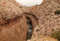
Looking up the narrows from the bottom and where one can access the rim:

Narrows_Bottom.jpg


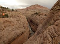
Along the rim:

Narrows_Rim.jpg


Along the rim near the top:
Narrows_Upper.jpg


OK... that's it.

If anybody gets out that way in the future please size up access at spot #2. Curious if it's even doable, but I think it's definitely NOT for the masses.
 
Last edited:

Nick

-
.
Joined
Aug 9, 2007
Messages
12,939
Awesome post, Jamal. I looked at spot #2 when I went past and didn't see anything I thought was possible. I wasn't trying to get out so I didn't think hard about it, but I specifically remember thinking anyone who could climb out there was at least partially super human (or super stupid).
 

slc_dan

Desert Rat-Weekend Warrior
Joined
Jun 7, 2012
Messages
1,687
It is hard to gauge unless you are there, but #2 looks doable from the photo's. If I make it out this summer, that's where I'm headed and I'll report back here. I wouldn't follow the water course exactly, but looks like you might be able to kinda zig zag down the sand stone.

(or super stupid).

You know me too well.
 

Nick

-
.
Joined
Aug 9, 2007
Messages
12,939
It is hard to gauge unless you are there, but #2 looks doable from the photo's. If I make it out this summer, that's where I'm headed and I'll report back here. I wouldn't follow the water course exactly, but looks like you might be able to kinda zig zag down the sand stone.


You know me too well.

I was actually going to use you as an example for the super human part. ;)
 

Jammer

❤2Hike
.
Joined
Feb 23, 2012
Messages
644
Ha! I was going to make a crack that maybe only Steve Allen, Kelsey or @slc_dan could do it! :)

Truth is... I kinda even think it looks doable now in photos. But, at the time, it definitely didn't look feasible (esp from top). But, I also questioned if I was in the right place so my confidence was low. I wish I'd walked up to the wall at the bottom as planned, but it was so brushy I got frustrated and just gave up.

Below is the same shot from under spot #2, but cropped in tight. Note the branch in top/center which also in the shot from above.

DetailZoom.jpg
 
Similar threads
Thread starter Title Forum Replies Date
ramblinman Boulder Creek Day Hike, Escalante National Monument Hiking & Camping 5
cmgz Boulder Mail Trail - Escalante Trailhead to Mamie Creek Hiking & Camping 1
J Who's done Steep Creek Canyon off Boulder Mtn folows into the Gulch at the Burr Trail? Trip Planning 3
Perry Spring Day Hike up Boulder Creek Hiking & Camping 2
Nick Boulder Creek, Escalante Backpacking 34
BJett Boulder Creek Backpacking 18
Tyler Boulder Mail trail to Sand Creek March 2012 Backpacking 3
Titans Boulder Mtn snow March 29- 2023 Photography 1
L Boulder Mail Trail April 2023 Qs Trip Planning 14
M Hollow Boulder Trip Planning 1
John Goering Boulder Lakes, Tobacco Root Mountains Off Road 0
RSchott Hello from Boulder, CO Noobs: Introduce yourself! 0
swmalone Restaurant Suggestions for Escalante or Boulder General Discussion 11
R Boulder Mail Trail to Death Hollow Trip Planning 1
LarryBoy Five Days on Boulder Mountain Backpacking 5
TrektheWorld Boulder Mail Trail - end of October? Trip Planning 18
Udink Boulder Top Hiking & Camping 4
WasatchWill To the Boulder Top Backpacking 9
Parma Idaho's White Cloud Mountains - Boulder Chain Lakes - Chamberlain Basin Backpacking 8
Brett Boulder Mail Trail - April 26-27, 2019 Backpacking 2
3DegreesSouth Paria/Buckskin Boulder Jam Trip Planning 6
ramblinman Food Fight: Article in the New Yorker about the Hell's Backbone Grill in Boulder, UT General Discussion 7
msteudel Boulder Mountain North Slope UT: Donkey Res. to Lost Lake? Trip Planning 1
wesleyS Road from Boulder airstrip, UT Hiking & Camping 5
Brett Boulder Mail Trail - Logistical Qs Trip Planning 10
Janice Loop possible with Boulder Mail Trail? Noobs: Introduce yourself! 8
Ugly In and Out - Boulder Mail Trail to DH Backpacking 9
S White Cloud route, Big Boulder Lakes to Boulder Chain Lakes Trip Planning 3
Jackson Death Hollow from the Boulder Mail Trail Backpacking 18
Skiwi Boulder Mail Trail to Death Hollow questions Trip Planning 8
M VIDEO - Bear Peak, Boulder, Colorado General Discussion 0
Bob Morris Glacier in 2 Weeks!!! (Boulder Pass Questions) Trip Planning 10
John Goering South Boulder River (Tobacco Root Mountains) day hikes. Hiking & Camping 8
muir_mountain Walker Ranch Loop, Boulder, CO Hiking & Camping 3
Jimmy Glacier Natl Park - Boulder Pass Trail Trip Planning 36
lostlandscapes Big Boulder Lakes, White Clouds -- July 3-5, 2015 Backpacking 12
Nico Boulder Mountain Trip Planning 19
Duke Which Lakes on the Boulder have no vehicle access General Discussion 7
Nick Boulder Mail Trail Backpacking 10
mattvogt7 Boulder Mail Trail, Jan 2014 Backpacking 13
steve Thanksgiving: Capitol Reef to Boulder Mountain Off Road 5
Nick Boulder Mail Trail in winter General Discussion 37
Jammer Boulder Mountain → Moab Hike Backpacking 14
Laura Aspen on Boulder Mountain Trip Planning 5
John Mckean Boulder Mail Trail to Highway 12 Backpacking 6
John Mckean Boulder mail trail to Hwy 12 bridge question General Discussion 6
Jammer Boulder to Moab Hike Video Backpacking 22
Colin Parker Boulder Mountain Suggestions Trip Planning 14
J Boulder Mail Trail Question General Discussion 2
Duke Lightning kills on Boulder mtn General Discussion 0

Similar threads

Don't like ads? Become a BCP Supporting Member and kiss them all goodbye. Click here for more info.

Top