- Joined
- May 24, 2015
- Messages
- 179
Between Bishop and Lone Pine, California sits the small town of Big Pine. West of town is Big Pine Creek, draining some of the High Sierra snowmelt. The creek canyon gives access to many of the Sierras 14'ers, including the Palisades group. The Creek splits into a South fork and a North fork. My daughter Holly and I wanted to explore both forks and possibly connect them by cross country passage over 11,800 ft contact pass. It was late August so we were hoping the huge 2019 sierra snow banks would be mostly melted to allow us to descend down the North face of contact pass. The rangers did not have any information on the status of the pass since no one had reported the conditions up to this point in the hiking season.
We were entering part of the John Muir Wilderness

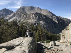
This is the start of hiking up the South fork of Big Pine Creek. Some of the Palisades and Norman Clyde Peak in the distance.

We had some small stream crossings a short climb and then we came upon Willow Lake. Actually more of a bog than anything. This area was producing a lot of mosquitoes since the water was not really moving much.
We passed some day hikers that were turning back because of the mosquitoes. The bugs were annoying but as long as we kept moving not too bad.
After some climbing we reached our destination for the day, Brainerd Lake. Once we came to a stop and started to set up camp the mosquitoes really took over.
I went fishing and had a bite on every cast. I stopped after three casts, not wanting to put up with the mozzies near the water. Holly decided it was not worth the exposure to go swimming.

We cooked dinner bubble boy style. First we set up the tent and made it mosquito free then we reached thru the doors to set up the stove outside and cooked our dinner. We ate inside the tent but cleaned up well and stored everything in the bear can. Eating in the tent is probably not recommended if in grizzly country. I have not seen a Sierra black bear at elevation in many years so we were not concerned.
A slight breeze picked up that allowed us to enjoy the sunset without too many bugs.

Waking up to more bugs influenced our hiking plans.

Rather than day hike any further up the south fork of Big Pine Creek we decided to start up towards Contact Pass. This would mean retracing our steps and crossing over the headwaters of Willow Lake. From there we would be using usage trails to work our way up to the pass. It took a lot longer than we expected.
Navigating up the creek canyon was easy but finding the easiest path thru the willows was time consuming.

After the willows there was a lot of scrambling over loose blocks.

The path was rather steep for full packs. Having come from sea level we had to stop quite often just to catch our breath. We hiked for hours not speaking a word to each other just dealing with the steepness of the trail and then regaining our breathing and hydrating. We may have both been a little nauseas from the exertion since neither of us wanted to eat but we knew we needed to. It was a good workout and in retrospect I believe we were following someones path that had come down the mountain.....a much more direct path. I should have been looking for a trail that was going up the pass, it probably would have had more traverses with less of an direct incline. Looking up the final pitch to the pass from our camp.

We decided to make camp on the South side of the pass where there was water and finish the climb in the morning. Holly was fortunate to find us a pool of snow melt water before it disappeared into the moraine.

Columbine at our high camp watering hole.

Another cloudless sierra sunset.

The next morning we finished the climb up to the pass not knowing if we would be able to safely descend the north side without ice axes or crampons. We agreed it would be prudent to turn back and hike back down the south fork trail if there was a steep sheet of ice blocking our path on the north side of Contact Pass.
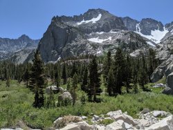
Nice scenery as we climbed up the pass.

From the top of the pass the view looking towards the south was picture perfect.

As we looked down the new view of the north side of the pass we could see a lot of snow but also a dry shoulder on one side for much of the way.
There was only a short patch of steep snow to descend but is was softening in the sun


At one point I started to slide on the steep snow before catching myself. Holly heard a loud snap and thought I had broken my leg.....fortunately it was just the tip of my hiking pole that broke as it caught a rockhole under the snow. We made it to a granite island then descended some more steep snow before reaching the safety of a more level snow bowl.

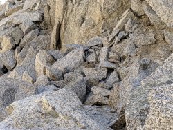
As we descended we could see the numbered lakes on the north side. Second Lake looked like it had more beach area for camping than Third Lake so we headed over there. First we had to descend a maze of loose slanted giant boulders. It was unnerving to step on a car size boulder and feel it wobble, then hear something five feet down the slope start to slide. We got off of that part of the hike as if it was on fire!
Third Lake on left and Second Lake on the right. Crazy loose boulder field in foreground.

Second lake

Second lake was a great reward for all of our hard work. A gorgeous beach front campsite with no mosquitoes and no crowds. Holly was able to swim in the lake.
I could fish without fighting off the bugs.


Temple Crag towers over the lake and makes every photo picturesque.
Holly cleaning out the water filter.

It would have been nice to day hike up to the peaks but we lost some trip time by underestimating the time to get over contact pass.
The next morning we started our hike out. The morning light really lit up the lake with some great high altitude glacial color.

The out flow from Second Lake down to First Lake
As we hiked down we started to see climbers joining us on the trails from above and many dayhikers coming up from below.

These bushes were still in bloom.

Some criss crossing trails as we neared the trailhead

Finally the view up South Fork signaled that we had completed our circuit.

Thanks for watching.
We were entering part of the John Muir Wilderness
This is the start of hiking up the South fork of Big Pine Creek. Some of the Palisades and Norman Clyde Peak in the distance.
We had some small stream crossings a short climb and then we came upon Willow Lake. Actually more of a bog than anything. This area was producing a lot of mosquitoes since the water was not really moving much.
We passed some day hikers that were turning back because of the mosquitoes. The bugs were annoying but as long as we kept moving not too bad.
After some climbing we reached our destination for the day, Brainerd Lake. Once we came to a stop and started to set up camp the mosquitoes really took over.
I went fishing and had a bite on every cast. I stopped after three casts, not wanting to put up with the mozzies near the water. Holly decided it was not worth the exposure to go swimming.
We cooked dinner bubble boy style. First we set up the tent and made it mosquito free then we reached thru the doors to set up the stove outside and cooked our dinner. We ate inside the tent but cleaned up well and stored everything in the bear can. Eating in the tent is probably not recommended if in grizzly country. I have not seen a Sierra black bear at elevation in many years so we were not concerned.
A slight breeze picked up that allowed us to enjoy the sunset without too many bugs.
Waking up to more bugs influenced our hiking plans.
Rather than day hike any further up the south fork of Big Pine Creek we decided to start up towards Contact Pass. This would mean retracing our steps and crossing over the headwaters of Willow Lake. From there we would be using usage trails to work our way up to the pass. It took a lot longer than we expected.
Navigating up the creek canyon was easy but finding the easiest path thru the willows was time consuming.
After the willows there was a lot of scrambling over loose blocks.
The path was rather steep for full packs. Having come from sea level we had to stop quite often just to catch our breath. We hiked for hours not speaking a word to each other just dealing with the steepness of the trail and then regaining our breathing and hydrating. We may have both been a little nauseas from the exertion since neither of us wanted to eat but we knew we needed to. It was a good workout and in retrospect I believe we were following someones path that had come down the mountain.....a much more direct path. I should have been looking for a trail that was going up the pass, it probably would have had more traverses with less of an direct incline. Looking up the final pitch to the pass from our camp.
We decided to make camp on the South side of the pass where there was water and finish the climb in the morning. Holly was fortunate to find us a pool of snow melt water before it disappeared into the moraine.
Columbine at our high camp watering hole.
Another cloudless sierra sunset.
The next morning we finished the climb up to the pass not knowing if we would be able to safely descend the north side without ice axes or crampons. We agreed it would be prudent to turn back and hike back down the south fork trail if there was a steep sheet of ice blocking our path on the north side of Contact Pass.
Nice scenery as we climbed up the pass.
From the top of the pass the view looking towards the south was picture perfect.
As we looked down the new view of the north side of the pass we could see a lot of snow but also a dry shoulder on one side for much of the way.
There was only a short patch of steep snow to descend but is was softening in the sun
At one point I started to slide on the steep snow before catching myself. Holly heard a loud snap and thought I had broken my leg.....fortunately it was just the tip of my hiking pole that broke as it caught a rockhole under the snow. We made it to a granite island then descended some more steep snow before reaching the safety of a more level snow bowl.
As we descended we could see the numbered lakes on the north side. Second Lake looked like it had more beach area for camping than Third Lake so we headed over there. First we had to descend a maze of loose slanted giant boulders. It was unnerving to step on a car size boulder and feel it wobble, then hear something five feet down the slope start to slide. We got off of that part of the hike as if it was on fire!
Third Lake on left and Second Lake on the right. Crazy loose boulder field in foreground.
Second lake
Second lake was a great reward for all of our hard work. A gorgeous beach front campsite with no mosquitoes and no crowds. Holly was able to swim in the lake.
I could fish without fighting off the bugs.
Temple Crag towers over the lake and makes every photo picturesque.
Holly cleaning out the water filter.
It would have been nice to day hike up to the peaks but we lost some trip time by underestimating the time to get over contact pass.
The next morning we started our hike out. The morning light really lit up the lake with some great high altitude glacial color.
The out flow from Second Lake down to First Lake
As we hiked down we started to see climbers joining us on the trails from above and many dayhikers coming up from below.
These bushes were still in bloom.
Some criss crossing trails as we neared the trailhead
Finally the view up South Fork signaled that we had completed our circuit.
Thanks for watching.
Attachments
Last edited:
")