Captainricco
Member
- Joined
- May 10, 2024
- Messages
- 5
I finally did it! Last month, October 2025, I returned to Capitol Reef to continue scouting and tackle the most difficult parts of the mostly off trail 'Beehive Traverse'. I spent two days exploring with a daypack without overnighting, before finally completing the traverse form Grand Wash to Pleasant Creek as an official backpack in two days - the 15th and 16th of Oct. This trip comes after my first venture to Capitol Reef last year, when my interest was piqued about the area, via Steve Howe's write up of the traverse. In May 2024, I spent a night on the southern most part of the traverse, which seemed achievable (and was), and absolutely got me hooked on finishing it someday.
As other bloggers have described, the route is indeed difficult and precise navigation is required. Many times you are exiting and entering neighboring canyons and washes via specific gullys and slabs that may be hidden or at first sight, not the first option you might identify. There are times where extremely exposed scrambling is required. I chose to wear a trail runner with vibram soles, ensuring a sticky contact to the slickrock (The new Altra Lone Peak 9+ with Vibram were great for this trip.)
I had spent the week leading up to this doing canyoneering with friends near Hanksville, UT. Because of this, I knew that rain had fallen many times during the night and that it was probable potholes would have water accessible, and confirmed this on my day hikes prior to the backpack.
My takeaways from the traverse is that it is indeed extremely remote and should be taken seriously. For most of the difficult part of the route going SOBO, I encountered only one other set of foot prints headed in a NOBO direction. This was kind of cool, that someone had just traversed it before me and knowing that we shared the same path. (Note: I found what I assume is this persons green sunglasses in sand about half way through - let me know if they belong to you!). The route seems to be intact just as Steve Howe has described, and other venturers have described since. All obstacles are as described, and no new obstacles were presented. All of my notes and research were pretty accurate, although there were some times you had to interpret the meanings of "scramble here, chimney here" etc. Additionally, I realized the importance of keeping this route retained to backpackers who understand its fragile beauty and ruggedness, which need to be protected. It was truly magical.
Thanks to the blogposts and videos from Jamal, Wasatch Will, and others, who gave me a feel of the what the traverse would look like. However, it was important that I not mistake other's experiences as my own ability and skill to tackle this route.
And thanks to Steve Howe, for discovering and sharing this remarkable route.

It rained during my one night on the traverse, tarp had to go up!

Blow Sand Canyon. True solitude and beauty.

Incredible view in Blow Sand Canyon of Golden Throne


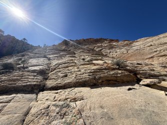
The exposed slab over dryfall, a major crux of the traverse.


The slot with a chest deep wade. I was able to stem over the deepest part, but it was a difficult maneuver with a 55L pack.

The "butt crack"! This part was fun.

Stemming in the crack.

Canyon headed toward Capitol Gorge Intersect.

Gotta have at least one fight with a cactus.

water was plentiful due to recent rain.

Nearing the end of the route, 3-4 miles from pleasant creek. Incredible views and amazing slick rock colors.

Iconic formation above bear canyon.

I saw two bighorn sheep during my traverse.

Astounding amount of cryptobiotic soil present. And yet in the middle of nowhere, I would find trails like this. Human? from Big horn sheep? Both?

My favorite view during the traverse. You can't get this anywhere else!

Looking North, from South and above of Capitol Gorge.

My "pet squirrel" I remembered from last year.


Beautiful AM rainbow the morning I woke up on BLM land East of the park, a sign it was time to finally complete the traverse!
As other bloggers have described, the route is indeed difficult and precise navigation is required. Many times you are exiting and entering neighboring canyons and washes via specific gullys and slabs that may be hidden or at first sight, not the first option you might identify. There are times where extremely exposed scrambling is required. I chose to wear a trail runner with vibram soles, ensuring a sticky contact to the slickrock (The new Altra Lone Peak 9+ with Vibram were great for this trip.)
I had spent the week leading up to this doing canyoneering with friends near Hanksville, UT. Because of this, I knew that rain had fallen many times during the night and that it was probable potholes would have water accessible, and confirmed this on my day hikes prior to the backpack.
My takeaways from the traverse is that it is indeed extremely remote and should be taken seriously. For most of the difficult part of the route going SOBO, I encountered only one other set of foot prints headed in a NOBO direction. This was kind of cool, that someone had just traversed it before me and knowing that we shared the same path. (Note: I found what I assume is this persons green sunglasses in sand about half way through - let me know if they belong to you!). The route seems to be intact just as Steve Howe has described, and other venturers have described since. All obstacles are as described, and no new obstacles were presented. All of my notes and research were pretty accurate, although there were some times you had to interpret the meanings of "scramble here, chimney here" etc. Additionally, I realized the importance of keeping this route retained to backpackers who understand its fragile beauty and ruggedness, which need to be protected. It was truly magical.
Thanks to the blogposts and videos from Jamal, Wasatch Will, and others, who gave me a feel of the what the traverse would look like. However, it was important that I not mistake other's experiences as my own ability and skill to tackle this route.
And thanks to Steve Howe, for discovering and sharing this remarkable route.
It rained during my one night on the traverse, tarp had to go up!
Blow Sand Canyon. True solitude and beauty.
Incredible view in Blow Sand Canyon of Golden Throne
The exposed slab over dryfall, a major crux of the traverse.
The slot with a chest deep wade. I was able to stem over the deepest part, but it was a difficult maneuver with a 55L pack.
The "butt crack"! This part was fun.
Stemming in the crack.
Canyon headed toward Capitol Gorge Intersect.
Gotta have at least one fight with a cactus.
water was plentiful due to recent rain.
Nearing the end of the route, 3-4 miles from pleasant creek. Incredible views and amazing slick rock colors.
Iconic formation above bear canyon.
I saw two bighorn sheep during my traverse.
Astounding amount of cryptobiotic soil present. And yet in the middle of nowhere, I would find trails like this. Human? from Big horn sheep? Both?
My favorite view during the traverse. You can't get this anywhere else!
Looking North, from South and above of Capitol Gorge.
My "pet squirrel" I remembered from last year.
Beautiful AM rainbow the morning I woke up on BLM land East of the park, a sign it was time to finally complete the traverse!