fossana
Member
- Joined
- Jan 11, 2018
- Messages
- 1,035
Logistics
Start/end: Squirrel Canyon trailhead
Mileage: ~10 miles with optional side trip to Short Creek pour-off
Difficulty: class 4
Navigation: Map/GPS may be useful. No signage, some cross-country travel.
Filterable water: seasonal
Designation: Canaan Mountain Wilderness Area
Fees: none
Nearest town/gas: Hildale UT, Colorado City AZ
Date hiked: 01 Jun 2019
Approximate Route

Route Description
From signed Squirrel Canyon trailhead, head into and up Short Creek to the Squirrel Creek junction. Go up Squirrel Creek briefly, cross the meadow and scramble up the dirt slope to the rocky the cliffy southern toe of the Beehive Ridge, staying just on the west side of the ridge proper. Following the easiest appearing path, you'll encounter the remnants of a handline up a short, but easy boulder problem just below an alcove. On the next tier, go right (south) until you encounter a short, featured 4th class chimney. Take this to the top of the ridge.
Spoiler Alert: if you want exact beta on where to gain the ridge, see the photo in the comments.
Follow the Beehive skyline to the north, passing a number of hoodoos. The true summit in an unassuming hoodoo near the northern edge before the descent slab.
Descend to the north, following a steeping slab. There are alternate ways to get down; I usually follow a long crack system (4thish class).
The fastest way back to the trailhead is to get on the old jeep road/trail heading west to the junction with the top of the Squirrel Canyon trail. Take Squirrel Canyon back to Short Creek and retrace your steps to the trailhead. Optionally, take a side trip along Birch Creek east, which eventually appears to cliffs out at pour-off into Short Creek. The potholes and pour-offs along this section are scenic; the illegal ATV traffic and tracks are not. For a longer hike, you can continue straight at the Squirrel Canyon junction, loop back down Water Canyon (4th class), then walk the dirt road a ways back to the other trailhead. The trail is ill-defined in spots, so a GPS or map helps.
Photos
Water Canyon and Short Creek


toe of Beehive ridge and on the ridge proper


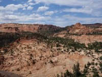
view northish from near the Beehive summit


slab downclimb

Birch Creek


heading back to the top of the Squirrel Canyon trail

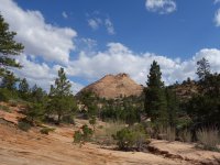
the Beehive from the west as seen from the Squirrel Canyon trail
 .
. 
Start/end: Squirrel Canyon trailhead
Mileage: ~10 miles with optional side trip to Short Creek pour-off
Difficulty: class 4
Navigation: Map/GPS may be useful. No signage, some cross-country travel.
Filterable water: seasonal
Designation: Canaan Mountain Wilderness Area
Fees: none
Nearest town/gas: Hildale UT, Colorado City AZ
Date hiked: 01 Jun 2019
Approximate Route
Route Description
From signed Squirrel Canyon trailhead, head into and up Short Creek to the Squirrel Creek junction. Go up Squirrel Creek briefly, cross the meadow and scramble up the dirt slope to the rocky the cliffy southern toe of the Beehive Ridge, staying just on the west side of the ridge proper. Following the easiest appearing path, you'll encounter the remnants of a handline up a short, but easy boulder problem just below an alcove. On the next tier, go right (south) until you encounter a short, featured 4th class chimney. Take this to the top of the ridge.
Spoiler Alert: if you want exact beta on where to gain the ridge, see the photo in the comments.
Follow the Beehive skyline to the north, passing a number of hoodoos. The true summit in an unassuming hoodoo near the northern edge before the descent slab.
Descend to the north, following a steeping slab. There are alternate ways to get down; I usually follow a long crack system (4thish class).
The fastest way back to the trailhead is to get on the old jeep road/trail heading west to the junction with the top of the Squirrel Canyon trail. Take Squirrel Canyon back to Short Creek and retrace your steps to the trailhead. Optionally, take a side trip along Birch Creek east, which eventually appears to cliffs out at pour-off into Short Creek. The potholes and pour-offs along this section are scenic; the illegal ATV traffic and tracks are not. For a longer hike, you can continue straight at the Squirrel Canyon junction, loop back down Water Canyon (4th class), then walk the dirt road a ways back to the other trailhead. The trail is ill-defined in spots, so a GPS or map helps.
Photos
Water Canyon and Short Creek
toe of Beehive ridge and on the ridge proper
view northish from near the Beehive summit
slab downclimb
Birch Creek
heading back to the top of the Squirrel Canyon trail
the Beehive from the west as seen from the Squirrel Canyon trail
. Attachments
Last edited:
