DrNed
The mountains are calling and I must go
- Joined
- Mar 31, 2013
- Messages
- 1,026
With this weekend's plans of getting into the Uintas for an end of season hike fizzle out, my wife could tell I was frustrated. So, this morning so she said to Bronwyn, my youngest daugher, "Will you please take your dad on a hike?!"
I didn't want to hike Grove Creek or Battlecreek Canyons which are our "no-where-else-to-hike" hikes. I wanted something new, but being short on time, I suggested starting at Mutual Dell in American Fork Canyon and hiking home.
So I rounded up a few things and my wife drove Bronwyn & I to Mutual Dell where we started up the Bear Canyon trail towards the Timpooneke road.
If you're unfamiliar with the Timpooneke road, it starts at the Timpooneke Camp Ground in American Fork Canyon, travels somewhat parallel to the canyon heading west and then comes around to the valley side of Mount Timpanogos traveling south until it ends about a half mile above the top of Battlecreek Canyon.
The Bear Canyon Trail starts at the top of the Mutual Dell parking lot and travels just over a mile from the trailhead to where it meets and road and it's more than a mild climb. It's in the tree the whole way up, typical Utah mountain trail scenery.

Once we got to the top we stopped for a Cliff Bar and some water and headed along the Timpooneke Rd.

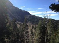
As you can see the road is in the trees as well. So there weren't a lot of views or great scenery, but if you're like me, you'll agree any day in the woods is a good day.
The one thing I wasn't prepared for was the amount of traffic on the road. I was under the impression that, yes there is a dirt road there, but no one really uses it much. Wrong! Apparently the deer hunt started recently too.
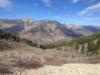
Fortunately, the road did open up in a few places and we got some nice views.
This one is looking back towards American Fork Canyon.


As you may have noticed, not a lot of color. None the less, we pressed on finally coming towards the front side of Timp. Here we are on the extreme north side of Timp., looking south.


Then something happened as we moved into the front side . . .
We got some great yellows and golds! The ridge in the background is the back side of Mount Mahogany, or if you happen to be driving along I-15 through Utah Valley, it's the "G" mountain.

The patch below looks like it is almost glowing.

While the golds were really nice, I was disappointed that there were no reds.
While there isn't any great scenery along this hike, this was my most favorite shot.

From the Bear Canyon Trailhead to the Timpooneke road to Battlecreek Canyon to my house was about fourteen miles (My phone died, losing my GPS, so the final mileage was estimated) and we did it in about five hours.
I didn't want to hike Grove Creek or Battlecreek Canyons which are our "no-where-else-to-hike" hikes. I wanted something new, but being short on time, I suggested starting at Mutual Dell in American Fork Canyon and hiking home.
So I rounded up a few things and my wife drove Bronwyn & I to Mutual Dell where we started up the Bear Canyon trail towards the Timpooneke road.
If you're unfamiliar with the Timpooneke road, it starts at the Timpooneke Camp Ground in American Fork Canyon, travels somewhat parallel to the canyon heading west and then comes around to the valley side of Mount Timpanogos traveling south until it ends about a half mile above the top of Battlecreek Canyon.
The Bear Canyon Trail starts at the top of the Mutual Dell parking lot and travels just over a mile from the trailhead to where it meets and road and it's more than a mild climb. It's in the tree the whole way up, typical Utah mountain trail scenery.
Once we got to the top we stopped for a Cliff Bar and some water and headed along the Timpooneke Rd.
As you can see the road is in the trees as well. So there weren't a lot of views or great scenery, but if you're like me, you'll agree any day in the woods is a good day.
The one thing I wasn't prepared for was the amount of traffic on the road. I was under the impression that, yes there is a dirt road there, but no one really uses it much. Wrong! Apparently the deer hunt started recently too.
Fortunately, the road did open up in a few places and we got some nice views.
This one is looking back towards American Fork Canyon.
As you may have noticed, not a lot of color. None the less, we pressed on finally coming towards the front side of Timp. Here we are on the extreme north side of Timp., looking south.
Then something happened as we moved into the front side . . .
We got some great yellows and golds! The ridge in the background is the back side of Mount Mahogany, or if you happen to be driving along I-15 through Utah Valley, it's the "G" mountain.
The patch below looks like it is almost glowing.
While the golds were really nice, I was disappointed that there were no reds.
While there isn't any great scenery along this hike, this was my most favorite shot.
From the Bear Canyon Trailhead to the Timpooneke road to Battlecreek Canyon to my house was about fourteen miles (My phone died, losing my GPS, so the final mileage was estimated) and we did it in about five hours.
") Side note - I woke up with very abnormal and terrible upper back pain this morning. I kept thinking, if only I lived in the UC, I'd go see Dr Ned! But of course, you were out hiking.
Side note - I woke up with very abnormal and terrible upper back pain this morning. I kept thinking, if only I lived in the UC, I'd go see Dr Ned! But of course, you were out hiking. ")