fossana
Member
- Joined
- Jan 11, 2018
- Messages
- 934
![86682 86682](https://backcountrypost.com/data/attachments/86/86699-86faf4021b1444b1bd7d98d8fade7f26.jpg)
Intro
Last winter I was looking for early season peak bagging opportunities and came across Harlan Stockman's trip report for Bat Mountain in the Funeral Mountains with photos of a tantalizing ridge traverse that chained the 2 main Bat peaklets. The winds ended up being bad on my original trip date, so when I had to pick up a bathroom vanity in Vegas, I decided to detour there afterward to do the climb. Harlan ended up avoiding the harder portion traverse, but Bob Burd hadn't. I'm familiar with Bob's technical climbing ability, so it seemed doable in my book.
Logistics
Permits: no
Water: no
Start/end: roadside parking along Hwy 190 (shoulder or dirt lot)
Mileage: ~10?
Navigation: No trails. Bring a topo map +/- GPS.
Reference: Bob Burd's TR, HW Stockman's TR
Approximate Route
![86707 86707](https://backcountrypost.com/data/attachments/86/86724-135da8761833cf7996172aab55eed876.jpg)
Trip Report
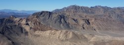
It was in the 30s when I left my van and the route Bob had taken to the ridge line (W Gully) was in the shade. Instead I opted for the traditional route Harlan has indicated on his map, which ascends a second class narrowing gully. The Mojave desert vegetation was sparse and the ground was covered with mostly limestone gravel, so the walking was fairly easy to the mouth of drainage. Once in the drainage the larger rocks contained interesting fossils and there were dried coyote melon/gourds (Cucurbita palmata) in the wash. I was happy to be mostly in the sun. The climb to the summit was uneventful and straightforward. The colors and undulations of the surrounding landscape were amazing.
![DSC01180.jpg DSC01180.jpg](https://backcountrypost.com/data/attachments/86/86700-23ef77384e656bc4d4ef7a7d9fa7b84b.jpg)
![DSC01185.jpg DSC01185.jpg](https://backcountrypost.com/data/attachments/86/86701-cd3c531764300318c53d45c0ef7b4671.jpg)
![DSC01198.jpg DSC01198.jpg](https://backcountrypost.com/data/attachments/86/86702-89ed9496067e4fec22b14152cccc4cbc.jpg)
![DSC01200.jpg DSC01200.jpg](https://backcountrypost.com/data/attachments/86/86703-2440131724bfb25da3ab01b0d353b8c7.jpg)
![DSC01206.jpg DSC01206.jpg](https://backcountrypost.com/data/attachments/86/86704-88cf63170cfb0b666d12ccfd22654fcb.jpg)
![DSC01213.jpg DSC01213.jpg](https://backcountrypost.com/data/attachments/86/86705-3898c8d4a21ae3e708537e54cbb22f24.jpg)
As I distanced myself from the S Bat summit, the knife-edged ridge came into view. According to Bob's write-up, at one point the route bypassed a gendarme on the improbable NW side of the ridge. I wasn't 100% sure which gendarme that was, but there were desert bighorn trails to guide the way. The detour came early on. Next the fun scrambling began. The rock was grippy limestone, fractured but not horribly chossy, and no harder than class 4. The sections that looked improbable from a distance turned out to doable. The ridge gave way to slabs for the final push to the N Bat summit.
![DSC01214.jpg DSC01214.jpg](https://backcountrypost.com/data/attachments/86/86706-bf64be743d7c211e3661351587903d20.jpg)
![DSC01216.jpg DSC01216.jpg](https://backcountrypost.com/data/attachments/86/86707-383ab9a323580705423b882b09cdd7ba.jpg)
![DSC01225.jpg DSC01225.jpg](https://backcountrypost.com/data/attachments/86/86708-59aa5749f6239979acc810ff47455b07.jpg)
![DSC01227.jpg DSC01227.jpg](https://backcountrypost.com/data/attachments/86/86709-0d8ab934599a2e8e601d36607960509a.jpg)
![DSC01229.jpg DSC01229.jpg](https://backcountrypost.com/data/attachments/86/86711-00565f2c5435628fea5cc56b409bb8a1.jpg)
![DSC01231.jpg DSC01231.jpg](https://backcountrypost.com/data/attachments/86/86712-d22fde211607a43d16bac927cba0c5af.jpg)
![DSC01232.jpg DSC01232.jpg](https://backcountrypost.com/data/attachments/86/86713-b6415856508b857d526885940b9f0e21.jpg)
![DSC01234.jpg DSC01234.jpg](https://backcountrypost.com/data/attachments/86/86714-4f924180f58a43a65f4bbf0008cfa0b8.jpg)
![DSC01235.jpg DSC01235.jpg](https://backcountrypost.com/data/attachments/86/86715-dbd48260b0cd22d86a2fc2627e7a7ad8.jpg)
From the N Bat summit I had 2 options: to the steeper NW, which involved routefinding challenges; or to the SE, which was easier and more straightforward. I chose the latter. I dropped down the slabs then into an obvious drainage, which ended in an easily bypassable, but high waterfall. The sides of the drainage grew steeper, so I stayed to the left until I could eventually drop back in. The route back was somewhat out of the way since one has to skirt the southern arm of the Funeral range. I eventually made it back and headed home.
![DSC01287.jpg DSC01287.jpg](https://backcountrypost.com/data/attachments/86/86716-4a78ad3151b49f3c6231aa3bd7d81625.jpg)
![DSC01291.jpg DSC01291.jpg](https://backcountrypost.com/data/attachments/86/86717-72ad069af1465eaa74608dbc2d128222.jpg)
![DSC01292.jpg DSC01292.jpg](https://backcountrypost.com/data/attachments/86/86718-8ef10c2eb07dabce34b11927c7e05e4e.jpg)
![DSC01310.jpg DSC01310.jpg](https://backcountrypost.com/data/attachments/86/86719-eca546818ff77900b3516b0bffd8f379.jpg)
![DSC01318.jpg DSC01318.jpg](https://backcountrypost.com/data/attachments/86/86720-e733fa61fa0371fdbea9703d960a25a4.jpg)
![DSC01323.jpg DSC01323.jpg](https://backcountrypost.com/data/attachments/86/86721-0969b5fedfd7b644c3878cd2d2c35f19.jpg)
![DSC01328.jpg DSC01328.jpg](https://backcountrypost.com/data/attachments/86/86722-a5ca16911cd44ea2a2e2b52f91d9bbb9.jpg)
![DSC01339.jpg DSC01339.jpg](https://backcountrypost.com/data/attachments/86/86723-0f95698b846c9e3605f82ca799c5ae51.jpg)