Joey
walking somewhere
- Joined
- Apr 1, 2014
- Messages
- 878
This is a 6 day backpack I did a few weeks ago over the Memorial Day week. This was an early season hike, and includes some off trail hiking. A large portion of the route was still snow covered. This is in the south west quadrant of Yellowstone National Park.
The route:
Click here to view on CalTopo
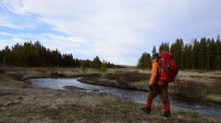
Day 1, May 28th: I got a pretty late start. I originally planned to do a completely different trip in a different section of the park. But after driving around to every open backcountry office, no one could answer my questions. So in the spur of the moment, I switched things up, and decided to go down to Shoshone. I got stuck for 2 hours in a bison jam near Old Faithful, and it was just after 5pm when I reached the DeLacy Creek Trailhead. Its a pretty easy walk from there down to Shoshone Lake, and includes some beautiful meadows. It's about 3 miles to the lake, and another mile to my campsite, 8S3.

.jpg")

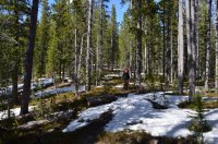
Hiking along the DeLacy Creek Meadows


Shoshone Lake

A close up view of Mount Sheridan, across Shoshone Lake.
I made my way along the shoreline towards my campsite. There are 2 great campsites nearby. 8S2 and 8S3. Both have great views along the lake, but 8S3 is my favorite. Its more private, and the food prep area is right on the water.

Looking back up the DeLacy Creek Meadows. The trail down from the road stays along the right hand side.

Food for the trip. Beer for Mr Bubbles.

I think this is a male grouse? I'm not exactly sure, but he was flirting hard with a female right in camp.


My tent and view from the food prep area on Shoshone Lake.

Another close up across the lake of Mount Sheridan.
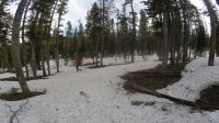
Day 2: I headed down the North Shoshone Trail, and planned to camp at the west end of the lake. Once the trail leaves the lake, it stays in lodgepole pine forest for almost the entire route. Although this is boring to some people, I seem to enjoy it, especially here. It brings back memories, as this is a hike I've done a lot over the years. I was expecting to encounter a lot of snow and post-holing, but it really wasn't bad. I've seen more snow in July here than I did this time in May. I passed a group of 3 people, and I wouldn't see another person until my last day hiking out.


Views from the food prep area in the morning.


Views as I hiked along the lake shore.


Views as I hike towards the west side of the lake. These pictures pretty much sum up about 9 miles of hiking.
Eventually I reached my campsite for the night, 8R5. Its a private site along a spur trail, maybe 1/4 mile from the main trail, and 1/2 mile from the Shoshone Geyser Basin. The food prep area is back in the trees a little above the lake, but there is a nice small beach as well.

Me at the food prep area.

My tent.


Views from the small beach at camp, where I ate dinner.
After I went to bed, a large thunderstorm came booming though, and it rained for a good portion of the night. It would be the only bad weather I had for the trip. I also stayed dry, which was a good sign, since I was (and currently am) using a make shift tent. I'm actually combining 3 different tents to form one. I have the footprint for my one man tent. I have a 2 man inner mesh tent. And a fly from my big 3 man tent. All of my tents are broken at this point, so I wasn't sure how it would work out. Turns out it works great!
Day 3: I started off the day by hiking over to the Shoshone Geyser Basin. This is one of the better backcountry thermal basins in the park, and has a great trail running through it. I feel like too many people take thermal areas for granted these days, especially since they are so easy to visit along the road. Its pretty freaking cool to look at these features. I always imagine how crazy it would be to come across these things 200 years ago. And the colors are amazing. (In my opinion, one of the best times to visit is in the fall, when you have crisp clear blue skies, which bring out the colors of all the pools.)

Me making my way towards the basin.


Several images from the Shoshone Geyser Basin. They are not in order, and I don't know the particular names of them.
After hiking through the basin, I continued south along the trail, crossing big meadows at the western edge of Shoshone Lake. This particular area is always marshy, and I was constantly walking in water. I was lucky that the mosquitoes weren't quite out yet.

Crossing Shoshone Creek


The meadows along the trail at the western end of Shoshone Lake.
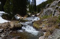
I reached Cold Mountain Creek, and left the trail here. I followed it up towards the continental divide, and Douglas Knob. I was constantly in and out of water the first mile or so, and then I was walking on snow the rest of the way. The canyon narrows for a short little while, and then the terrain flattens out. There where several small cascades and waterfalls. Near the end of the drainage its a steep climb up to the ridge top.

Looking up Cold Mountain Creek. The meadows end shortly, and the canyon narrows.


Views hiking up the narrow part of Cold Mountain Creek


At the top of the ridge, with Shoshone Lake in the background.
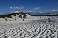
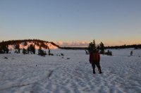
At the top, I simply had to drop down the other side, and follow the drainage right down to backcountry campsite 9D3. I had done this last June, so I thought I knew the way. But with all the snow, I got confused. I ended up heading south for a while, and by the time I realized my mistake, the ridge was much wider. It probably cost me at least an hour or more of extra hiking. Post holing through snow, actually. I ended up coming out much closer to Douglas Knob than I wanted to. I made my way out to the big meadows in front of it, and headed up to my campsite. The area was 100% snow covered. I managed to find a dry spot to set my tent up on. I was using a light air pad, and didn't want to sleep on snow. It felt awesome up there, almost like fall. I had one of my best nights of the year so far. It was so quiet and tranquil.


Crossing the top of the ridge, trying to make my way towards the Douglas Knob Meadows.

Finally making it out to the meadows, well south of where my campsite was. Douglas Knob is to the left.


Making my way across the meadows towards backcountry campsite 9D3.

The campsite marker

The pit toilet

My tent, on the only bare ground I could find big enough for my tent (and away from my food).

Melting snow for water. There was no running water near by.

Me at camp in the evening, Douglas Knob and the meadows behind me. The Bechler Canyon starts dropping down right behind Douglas Knob.
Day 4: I headed down the Bechler Canyon. It was 100% snow covered until I reached the meadows at the spur trail for Mr Bubbles. I had thought about camping at Greggs Fork, to have a campfire (since I knew nobody was going to be there), but the fire pit was covered with snow. So down I went to the Three Rivers Junction campsite, 9D1. Surprisingly I managed to stay pretty close to the actual trail, constantly seeing trail markers. It was a beautiful day. The snow was hard enough that I wasn't post holing much. Still, I was happy to make it down to camp and not have to camp on snow.


Crossing the big meadows in the morning (more like noon") ).
).

The top of the Bechler Canyon.


The area around the Gregg Fork campsite was beautiful, with the creek running through.
After I reached camp, I quickly set up my tent, then headed off for Mr Bubbles. Campsite 9D1 is pretty neat by itself. It has some nice thermal features flowing into the river right there in camp. In lower water, there is a damned up pool of hot water you can soak in. Three different rivers join just below the camp to form the Bechler River. There are some really nice views in the area. By this time I was running out of camera batteries, so I didn't take many shots of the area. I have documented this area in a few other trip reports and videos. Its about a 1/2 mile walk from the campsite up the Ferris Fork to Mr Bubbles. Mr Bubbles has an official name that I can't remember off the top of my head. Its a larger hot pool that you can soak in. It's pretty popular in the summer with backpackers, and you often have to share the pool. But in the spring and fall you usually have it to yourself. The area around Mr Bubbles has some amazing thermal features to look at. There are also some nice waterfalls up the Ferris Fork, including a pretty big one just up the creek.

A view of the river running right through camp at Three River's Junction (9D1)

A view of my tent at camp.

The wildflowers were blooming along the Ferris Fork.

 The pretty sweet thermal feature right before you get to Mr Bubbles.


Several photos of me in Mr. Bubbles.
This was the 4th time i've been to Mr. Bubbles. Every other time has been different. But this was the first time I found it hard to enjoy. There was a pretty thick layer of cake like debris on the bottom of the pool. In some places I would sink in so much I almost though I was busting through the floor. Every step stirred up the debris, and it just wasn't very fun to sit in. The pool was also much cooler than normal. Perhaps due to the snow melt. The small side stream that comes in is normally very hot. This time is actually felt cold. I was able to find a nice spot free of debris that was somewhat warm, and I sat there for a while drinking my beers. And it was still awesome being out there. Its such a beautiful area to hang out in, especially by myself. I retired earlier to camp than I planned, and had a solid nights sleep. I should also add this was the only place I had bad mosquitoes on the trip. Normally this whole route is terrible early in the summer. But May was too early.
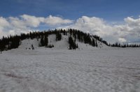
Day 5: My destination for the day was Moose Creek along the south side of Shoshone lake. I could use the trail system, but that would add a bunch of miles. Since half of that was snow covered anyways, I decided to travel off trail towards my destination. I started by backtracking all the way back to near Douglas Knob. Then I decided to follow the meadows on its south east side. This is where the old Pitchstone Plateau trail used to connect to the Bechler River Trail. I followed the snow covered meadows up until the canyon got steep and narrow. It was really beautiful in there. I found myself on some steep snow slopes, and just decided to climb to the top. You could almost say I was on the northern most edge of the Pitchstone Plateau. From there I headed due east. It was a little difficult to figure out with out a compass or GPS, and no landmarks to look at. I traveled through thick forest that was 100% snow covered. At times I wasn't exactly sure where I was. I stumbled into an old trail marker for the Pitchstone Trail I mentioned above. Eventually I reached the top of one of the feeder streams to Moose Creek. I could see the meadows far out in the distance. I had a steep decent for a few miles. I kind of got exhausted, and didn't take many shots along the hike. It was a long slog down the drainage, stepping over downfall, post holing through snow, endlessly going down. I hadn't seen water in a while, so my only source of hydration was eating snow. Eventually I reached the meadows, and slowly walked for another hour before finally reaching my campsite, 8M2. Moose Creek is very beautiful here. It meanders along through the meadows, which aren't particularly wide, but stretch a few miles long. The snow was mostly melted around the campsite. I had a fire, and stayed up late on another quiet night.

Hiking up the meadows just south east of Douglas Knob. The old Pitchstone Trail crosses these meadows.


The old trail marker. The top picture shows the tree it was on. The marker says "North Pitchstone Trail", has an arrow pointing west and then says "Bechler River Trail 2 Miles".

Not a great image, but this is me above the Moose Creek drainage. You can't really see how steep the canyon gets, but this is the only shot I have of it.
.jpg")

Walking along Moose Creek.


Views of Moose Creek near campsite 8M2

My tent spot.

Enjoying a fire in camp.
Day 6: This was my last day of the trip. I didn't take many shots, since I was both out of camera juice, and in a hurry to get out to my van so I could get a shower before they closed for the night. It was roughly 12 miles back to the DeLacy Creek trail head, all by trail. I was expecting to still have snow on the trail, but there really wasn't much. It was a beautiful, wooded hike. There were 2 sets of bear tracks along the trail, traveling the way I was going. But I didn't see any. This was pretty much the only bear sign I saw the entire trip. I had to cross Moose Creek, and then the Lewis Channel, which runs from Shoshone Lake down to Lewis Lake. Both were easy crossings. Then I took the trail along the east shore of Shoshone Lake for several miles north. One section of this trail is right on the water. But most of it is in the trees, and manages to do far more up and down than necessary. It started to rain on me just as I made my way back to the trailhead.

Me along Moose Creek in the morning.

Hiking along Moose Creek


Crossing Moose Creek

The big open meadows where Moose Creek joins Shoshone Lake. One of the few spots along the south trail where you can see Shoshone Lake.

About to reach the Lewis Channel.


Crossing the Lewis Channel.


Walking along Shoshone Lake's eastern shore.
The end. Some of these photos are stills that I pulled from video. One of the lens has a smear on it, which is why some of the shots seem blurry.
This trip report was written inside 2 different McDonalds and the library in West Yellowstone over the course of 2 days. Lots of commotion between the excited kids and tourists. And the preschool took a field trip to the library while I was there. So my apologies if this isn't up to par. I appreciate those who take the time to check these out.
Thanks, Joey
The route:
Click here to view on CalTopo
Day 1, May 28th: I got a pretty late start. I originally planned to do a completely different trip in a different section of the park. But after driving around to every open backcountry office, no one could answer my questions. So in the spur of the moment, I switched things up, and decided to go down to Shoshone. I got stuck for 2 hours in a bison jam near Old Faithful, and it was just after 5pm when I reached the DeLacy Creek Trailhead. Its a pretty easy walk from there down to Shoshone Lake, and includes some beautiful meadows. It's about 3 miles to the lake, and another mile to my campsite, 8S3.
Hiking along the DeLacy Creek Meadows
Shoshone Lake
A close up view of Mount Sheridan, across Shoshone Lake.
I made my way along the shoreline towards my campsite. There are 2 great campsites nearby. 8S2 and 8S3. Both have great views along the lake, but 8S3 is my favorite. Its more private, and the food prep area is right on the water.
Looking back up the DeLacy Creek Meadows. The trail down from the road stays along the right hand side.
Food for the trip. Beer for Mr Bubbles.
I think this is a male grouse? I'm not exactly sure, but he was flirting hard with a female right in camp.
My tent and view from the food prep area on Shoshone Lake.
Another close up across the lake of Mount Sheridan.
Day 2: I headed down the North Shoshone Trail, and planned to camp at the west end of the lake. Once the trail leaves the lake, it stays in lodgepole pine forest for almost the entire route. Although this is boring to some people, I seem to enjoy it, especially here. It brings back memories, as this is a hike I've done a lot over the years. I was expecting to encounter a lot of snow and post-holing, but it really wasn't bad. I've seen more snow in July here than I did this time in May. I passed a group of 3 people, and I wouldn't see another person until my last day hiking out.
Views from the food prep area in the morning.
Views as I hiked along the lake shore.
Views as I hike towards the west side of the lake. These pictures pretty much sum up about 9 miles of hiking.
Eventually I reached my campsite for the night, 8R5. Its a private site along a spur trail, maybe 1/4 mile from the main trail, and 1/2 mile from the Shoshone Geyser Basin. The food prep area is back in the trees a little above the lake, but there is a nice small beach as well.
Me at the food prep area.
My tent.
Views from the small beach at camp, where I ate dinner.
After I went to bed, a large thunderstorm came booming though, and it rained for a good portion of the night. It would be the only bad weather I had for the trip. I also stayed dry, which was a good sign, since I was (and currently am) using a make shift tent. I'm actually combining 3 different tents to form one. I have the footprint for my one man tent. I have a 2 man inner mesh tent. And a fly from my big 3 man tent. All of my tents are broken at this point, so I wasn't sure how it would work out. Turns out it works great!
Day 3: I started off the day by hiking over to the Shoshone Geyser Basin. This is one of the better backcountry thermal basins in the park, and has a great trail running through it. I feel like too many people take thermal areas for granted these days, especially since they are so easy to visit along the road. Its pretty freaking cool to look at these features. I always imagine how crazy it would be to come across these things 200 years ago. And the colors are amazing. (In my opinion, one of the best times to visit is in the fall, when you have crisp clear blue skies, which bring out the colors of all the pools.)
Me making my way towards the basin.
Several images from the Shoshone Geyser Basin. They are not in order, and I don't know the particular names of them.
After hiking through the basin, I continued south along the trail, crossing big meadows at the western edge of Shoshone Lake. This particular area is always marshy, and I was constantly walking in water. I was lucky that the mosquitoes weren't quite out yet.
Crossing Shoshone Creek
The meadows along the trail at the western end of Shoshone Lake.
I reached Cold Mountain Creek, and left the trail here. I followed it up towards the continental divide, and Douglas Knob. I was constantly in and out of water the first mile or so, and then I was walking on snow the rest of the way. The canyon narrows for a short little while, and then the terrain flattens out. There where several small cascades and waterfalls. Near the end of the drainage its a steep climb up to the ridge top.
Looking up Cold Mountain Creek. The meadows end shortly, and the canyon narrows.
Views hiking up the narrow part of Cold Mountain Creek
At the top of the ridge, with Shoshone Lake in the background.
At the top, I simply had to drop down the other side, and follow the drainage right down to backcountry campsite 9D3. I had done this last June, so I thought I knew the way. But with all the snow, I got confused. I ended up heading south for a while, and by the time I realized my mistake, the ridge was much wider. It probably cost me at least an hour or more of extra hiking. Post holing through snow, actually. I ended up coming out much closer to Douglas Knob than I wanted to. I made my way out to the big meadows in front of it, and headed up to my campsite. The area was 100% snow covered. I managed to find a dry spot to set my tent up on. I was using a light air pad, and didn't want to sleep on snow. It felt awesome up there, almost like fall. I had one of my best nights of the year so far. It was so quiet and tranquil.
Crossing the top of the ridge, trying to make my way towards the Douglas Knob Meadows.
Finally making it out to the meadows, well south of where my campsite was. Douglas Knob is to the left.
Making my way across the meadows towards backcountry campsite 9D3.
The campsite marker
The pit toilet
My tent, on the only bare ground I could find big enough for my tent (and away from my food).
Melting snow for water. There was no running water near by.
Me at camp in the evening, Douglas Knob and the meadows behind me. The Bechler Canyon starts dropping down right behind Douglas Knob.
Day 4: I headed down the Bechler Canyon. It was 100% snow covered until I reached the meadows at the spur trail for Mr Bubbles. I had thought about camping at Greggs Fork, to have a campfire (since I knew nobody was going to be there), but the fire pit was covered with snow. So down I went to the Three Rivers Junction campsite, 9D1. Surprisingly I managed to stay pretty close to the actual trail, constantly seeing trail markers. It was a beautiful day. The snow was hard enough that I wasn't post holing much. Still, I was happy to make it down to camp and not have to camp on snow.
Crossing the big meadows in the morning (more like noon
).The top of the Bechler Canyon.
The area around the Gregg Fork campsite was beautiful, with the creek running through.
After I reached camp, I quickly set up my tent, then headed off for Mr Bubbles. Campsite 9D1 is pretty neat by itself. It has some nice thermal features flowing into the river right there in camp. In lower water, there is a damned up pool of hot water you can soak in. Three different rivers join just below the camp to form the Bechler River. There are some really nice views in the area. By this time I was running out of camera batteries, so I didn't take many shots of the area. I have documented this area in a few other trip reports and videos. Its about a 1/2 mile walk from the campsite up the Ferris Fork to Mr Bubbles. Mr Bubbles has an official name that I can't remember off the top of my head. Its a larger hot pool that you can soak in. It's pretty popular in the summer with backpackers, and you often have to share the pool. But in the spring and fall you usually have it to yourself. The area around Mr Bubbles has some amazing thermal features to look at. There are also some nice waterfalls up the Ferris Fork, including a pretty big one just up the creek.
A view of the river running right through camp at Three River's Junction (9D1)
A view of my tent at camp.
The wildflowers were blooming along the Ferris Fork.
The pretty sweet thermal feature right before you get to Mr Bubbles.Several photos of me in Mr. Bubbles.
This was the 4th time i've been to Mr. Bubbles. Every other time has been different. But this was the first time I found it hard to enjoy. There was a pretty thick layer of cake like debris on the bottom of the pool. In some places I would sink in so much I almost though I was busting through the floor. Every step stirred up the debris, and it just wasn't very fun to sit in. The pool was also much cooler than normal. Perhaps due to the snow melt. The small side stream that comes in is normally very hot. This time is actually felt cold. I was able to find a nice spot free of debris that was somewhat warm, and I sat there for a while drinking my beers. And it was still awesome being out there. Its such a beautiful area to hang out in, especially by myself. I retired earlier to camp than I planned, and had a solid nights sleep. I should also add this was the only place I had bad mosquitoes on the trip. Normally this whole route is terrible early in the summer. But May was too early.
Day 5: My destination for the day was Moose Creek along the south side of Shoshone lake. I could use the trail system, but that would add a bunch of miles. Since half of that was snow covered anyways, I decided to travel off trail towards my destination. I started by backtracking all the way back to near Douglas Knob. Then I decided to follow the meadows on its south east side. This is where the old Pitchstone Plateau trail used to connect to the Bechler River Trail. I followed the snow covered meadows up until the canyon got steep and narrow. It was really beautiful in there. I found myself on some steep snow slopes, and just decided to climb to the top. You could almost say I was on the northern most edge of the Pitchstone Plateau. From there I headed due east. It was a little difficult to figure out with out a compass or GPS, and no landmarks to look at. I traveled through thick forest that was 100% snow covered. At times I wasn't exactly sure where I was. I stumbled into an old trail marker for the Pitchstone Trail I mentioned above. Eventually I reached the top of one of the feeder streams to Moose Creek. I could see the meadows far out in the distance. I had a steep decent for a few miles. I kind of got exhausted, and didn't take many shots along the hike. It was a long slog down the drainage, stepping over downfall, post holing through snow, endlessly going down. I hadn't seen water in a while, so my only source of hydration was eating snow. Eventually I reached the meadows, and slowly walked for another hour before finally reaching my campsite, 8M2. Moose Creek is very beautiful here. It meanders along through the meadows, which aren't particularly wide, but stretch a few miles long. The snow was mostly melted around the campsite. I had a fire, and stayed up late on another quiet night.
Hiking up the meadows just south east of Douglas Knob. The old Pitchstone Trail crosses these meadows.
The old trail marker. The top picture shows the tree it was on. The marker says "North Pitchstone Trail", has an arrow pointing west and then says "Bechler River Trail 2 Miles".
Not a great image, but this is me above the Moose Creek drainage. You can't really see how steep the canyon gets, but this is the only shot I have of it.
Walking along Moose Creek.
Views of Moose Creek near campsite 8M2
My tent spot.
Enjoying a fire in camp.
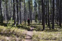
Day 6: This was my last day of the trip. I didn't take many shots, since I was both out of camera juice, and in a hurry to get out to my van so I could get a shower before they closed for the night. It was roughly 12 miles back to the DeLacy Creek trail head, all by trail. I was expecting to still have snow on the trail, but there really wasn't much. It was a beautiful, wooded hike. There were 2 sets of bear tracks along the trail, traveling the way I was going. But I didn't see any. This was pretty much the only bear sign I saw the entire trip. I had to cross Moose Creek, and then the Lewis Channel, which runs from Shoshone Lake down to Lewis Lake. Both were easy crossings. Then I took the trail along the east shore of Shoshone Lake for several miles north. One section of this trail is right on the water. But most of it is in the trees, and manages to do far more up and down than necessary. It started to rain on me just as I made my way back to the trailhead.
Me along Moose Creek in the morning.
Hiking along Moose Creek
Crossing Moose Creek
The big open meadows where Moose Creek joins Shoshone Lake. One of the few spots along the south trail where you can see Shoshone Lake.
About to reach the Lewis Channel.
Crossing the Lewis Channel.
Walking along Shoshone Lake's eastern shore.
The end. Some of these photos are stills that I pulled from video. One of the lens has a smear on it, which is why some of the shots seem blurry.
This trip report was written inside 2 different McDonalds and the library in West Yellowstone over the course of 2 days. Lots of commotion between the excited kids and tourists. And the preschool took a field trip to the library while I was there. So my apologies if this isn't up to par. I appreciate those who take the time to check these out.
Thanks, Joey
Attachments
-
 13407310_10154295684174766_6738130118252683018_n.jpg71.7 KB · Views: 32
 -
 13450259_10154295678939766_7111536781018051477_n.jpg119.3 KB · Views: 28
 -
 13466219_10154295540554766_5940015096004435616_n.jpg84.1 KB · Views: 29
 -
 13494770_10154295539449766_3421638586102859537_n.jpg66.9 KB · Views: 30
 -
 13497822_10154295534394766_924095839987840503_o.jpg167.5 KB · Views: 33
 -
 13501601_10154295540419766_4164588574896948195_n.jpg101.4 KB · Views: 32
 -
 13501643_10154295538414766_5813317040765378940_n.jpg155.6 KB · Views: 31
 -
 13511984_10154295533424766_8139281550142517150_n.jpg173 KB · Views: 30
 -
 13516516_10154295542309766_5812233323291458473_n.jpg62.2 KB · Views: 32
 -
 13516724_10154295539654766_5607314648143106777_n.jpg69.4 KB · Views: 29
 -
 13522005_10154295532904766_8469581779486146692_n.jpg183.1 KB · Views: 30