Backpacking Ruby Mtns or Great Basin NP

ogg

Member
Joined
Jan 23, 2015
Messages
56
I'm looking for suggestions for cool 1-3 night backpack trips in either the Ruby Mtns or Great Basin NP. I'm sort of new to exploring this region. I've done much backpacking in the Eastern Sierra, not far from where I live in California. I'm comfortable with moderate off-trail travel and love hiking in high country. Last summer had the opportunity to do a few nice dayhikes in the Spring Mtns near Las Vegas and really enjoyed it, so I'm looking forward to expanding my range a bit more.
 
I have never been to Great Basin NP, but a few years ago I did a 4 day loop in the Rubies. The main issue with loops in the Rubies is the way the mountains are laid out. There is one main ridge that the Ruby Crest Trail follows. To do any sort of loop you end up having to hike to the ridge, then come back down and cross country it back to your car. Much of the land on either side of the Rubies is private land.

For what you want to do, I would think the Lakes Loop would be your best shot. It starts in the center of the Rubies, which is about the only place that you can do any sort of loop and avoid having to cross country it along the East or West side of the range. I wanted a longer/harder trip, and ended up making my own route.
 
I've also spent some time there - day hiking in from Lamoille on the north end of the Crest Trail and then a one night, 15-miler as a recon in from the south end of the Crest. All this is to setup me doing the whole Crest trail at some time. I've also done a longish loop day hike mostly off trail up by Lamoille. So, no real new info on loops.
Two observations I'd make:
- water is an issue in the Ruby's - at least on the Crest trail and to a degree elsewhere. It is desert range with not a lot of lakes and streams. I may be biased on that spending most of my time on the summit ridge and there tends not to be water on ridges....
- there is a great deal of cow damage - especially the south end of the range seems to be cow hammered with some domestic sheep grazing as well.
 
@langutah - I had given the Crest Trail some thought. Do you know how far it is from Harrison Pass in the south to Overland Lake? Would that be your water source heading north or does it dry up eventually as the summer goes along?
 
@langutah - I had given the Crest Trail some thought. Do you know how far it is from Harrison Pass in the south to Overland Lake? Would that be your water source heading north or does it dry up eventually as the summer goes along?
Hi Hugh, I was just working from memoryto help ogg out. I will have to pull out a map and refresh my memory on the distances and my planned watering locations. Sorry. I can sure do that. Actually that backpacking in the ruby's site that fiber linked to above is one of the critical reference sources.
My actual plan involving water was to do as I did in my recon - walk with some snow left on the ground - then there is good run off water to use.

@ogg sorry to jack your thread if I am.. might be TMI or maybe you want more... if so I could probably be teased into a mini trip report..

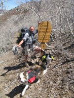
Me and part of the crew at the start of the wilderness from the south.

ruby_8.jpg
 
Some info from my files:

Route: The Ruby Crest Trail
(FT 043) runs from Lamoille Canyon to graveled NV 228 at Harrison Pass.
Best campsites are at Castle Lake, the north fork of Overland Creek, Overland Lake, McCutcheon Creek, and springs 1.5 miles south of McCutcheon Creek.
In dry months, water is unavailable for 13 miles between North Furlong Lake and the north fork of Overland Creek.
The southern 6 miles to Harrison Pass are also dry.
Echo Canyon provides access to Ruby Dome, the range’s highest peak at 11,387 feet.
The Soldier Basin (031) and Soldier-Griswold Trails (032) begin 20 miles north of the town of Lamoille, climbing 5 miles to lakes in Soldier Basin and beyond.
Other useful trunk trails ascend North Furlong Canyon (045), Long Canyon (046), and Overland Canyon (047).

Harrison Pass to McCrutcheon Crk 9m. McCrutcheon Crk to Overland Lk 9m. Overland Lk to Furlong Lk 14m. Furlong LK to Lamoile Cyn 10m.

GO here: http://www.rubymountains.net/
http://rubymountaintrails.blogspot.com/2010/09/ruby-crest-trail.html

Also put in resources section......
 
Some good info and leads here, thanks to all.

@langutah, no worries. No such thing as TMI for trip planning for me, the planning is half the fun!

My time frame is roughly the last week of June. I wonder how the snow pack in the Ruby Mtns and Snake Range was last year around the same time?
 
Back
Top