Born to Hike
Member
- Joined
- Jan 14, 2017
- Messages
- 146
Hi again!
I had so much fun hiking the Winds in August, I wanted to do one more trip I had not yet done before: a thru-hike in the Northern part of the range starting at Green River Lakes, heading South to scale Knapsack Cole, visit Titcomb Basin, then on to Lake Victor and make my way to the Boulder Lake Trail Head, hopefully hearing the Elk bugle along the way. It was later in September (the 17th) than I wanted though, but the weather forecast looked mostly dry and my wife was willing to drop me off then later pick me up at Boulder Lake. I couldn't pass that up!
What actually happened Itinerary (it changed from the original plan):
Sept 17: Drive 6 hours to Green River Lakes, then boogie on the Highline Trail following the Green River to Three Forks Park before dark (11.5+ miles).
Sept 18: Climb to Vista Pass, then up to Cube Rock Pass, then up and over Knapsack Col then down into Titcomb Basin (a LONG DAY 15 miles).
Sept 19: Explore through Titcomb and further on to Island Lake, then off-trail to Wall Lake (9.5 miles).
Sept 20: Navigate around Wall Lake to Cook Lakes, then back on the Highline Trail heading South past Pole Creek Lakes to Chain Lakes (9 miles).
Sept 21: Continued South past Barnes Lake and Horseshoe Lake, checked out Lake George and Coyote Lake, then on the Ruff Lake Trail to the Boulder Lake Trailhead (15+ miles).
Pack ready to go: A full 85 Liter pack for this trip with gear including 17 lbs of food for 6 full days and 10 extra pounds of clothing and sleeping gear (than I normally carry) for the colder weather (temps dropping in the low 20's), gear for rain/snow, plus 2 closed-cell sleeping pads for my dogs to help them stay warm at night. 50 + lbs!

Day #1
My dear wife dropping me off at Green River Lakes and sending me off.


I started around 2:30 pm that 1st day. It was the warmest and nicest day of the trip. SMOKEY, but bug free.

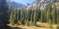
Square Top Mountain was ahead of me for the 1st 3 miles. Hazy, but gorgeous.

.jpg")
The aspens that grow in the lower elevations (8,500' or lower) showing their fall-colored glory.

The trail that day followed the Green River the entire way including Three Forks Park were I camped that 1st night. After passing Square Top, I did not see another person till Day #3 in Titcomb Basin.

Just past Square Top I was impressed by this well built foot bridge crossing the Green River. Even this late in the year the Green River this far up in the Winds was full of water. Grateful to keep my feet dry.

Just a few days before a huge fire started 40 miles away at Hoback Junction that would plague me with smoke most of the trip. The pic below looks like the sun has gone down, but it was 4 in the afternoon with the sun up and blocked by the smoke. I would occasionally see ash falling out of the sky. A little eerie to experience. Still happy to be there!
I made it to Three Forks Park just as the sun was setting. For a few minutes the smoke cleared a bit, allowing a few stellar sun setting pics.


The dogs still have their summer coats, so to help them (especially the lab) not freeze at night they brought along their own very fashionable (I found the sweaters on clearance at Walmart a few years ago for cheap) dog sweaters. They never acted too put-out by them.
That night we woke up hearing our 1st Elk bugle in the wild - around 2am. The dogs were not familiar with that sound and were freaking out and I almost didn't stop them from taking off in the middle of the night after the Elk, but they settled down quickly and we went back to sleep. Way cool to hear the Elk!

Day #2
The night before it actually rained for about 20 minutes and the first part of the day was fairly clear of smoke, and much cooler. From this point I would ascend 4,000 vertical feet for the next 12 miles.
View of Three Forks Park looking South.

Very nice fall colors even on the switchbacks.

This junction sign was a little confusing and was grateful for my Garmin GPS. I headed towards "Elbow Lake".

Not long after this sign made much more sense and I turned here towards Vista Pass.

Vista Pass, and a nice place to camp if need be, but I continued on towards Dale Lake. The weather so far was cool and perfect for backpacking, gaining elevation the entire route so far.

After Vista Pass, you DROP elevation for a while, and I was not very excited losing altitude. I must admit though the views and solitude took away any disappointments of losing elevation.

Looking back into the glacial valley of the Green River were I camped the night before.

From here the trail is not maintained and disappears completely while navigating uphill through massive boulders and boulder fields. This is what was ahead of me.

In the last 24 hours hauling a 50+ pack, hiking 16+ miles, climbing over 2,000 feet I was beginning to feel it, which surprised me little. The last 4.5 miles took me over 3 hours - very slow for me. I think this pic tells it all how I was feeling..

I really wanted to ascend the Col that day, so I dropped my pack, took off the dogs' packs which Diesel (the Lab) was happy to be rid of..

and chilled for an hour while eating copious amounts of high-energy (calories and protein) foods..


While enjoying the view, and sunshine.

Now it was boulder hopping/scrambling/try-not-to-fall-or-injure-yourself/climbing. Slow going to say the least.


See the small area of "green" grass in the background past the boulder field? Going from there to were this picture was taken took 45 minutes!

Soon we headed left just past were Ollie (the dog) is and in classic Windriver fashion the scenery abrupt changed:

Dale Lake and Stroud Peak.

Walking past Dale Lake towards Cube Rock Pass. Is this the "Cube"?

Looking back over Dale Lake. I was awestruck with the views around me.

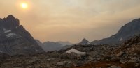
Peak Lake with Split Mountain in the background. Many camp here for the night and THEN ascend Knapsack Cole, but I had at least 4 hours of daylight and was determined to reach the Col so I continued on around the lake (to the left).

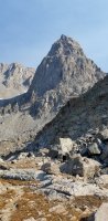
Finally I could see Knapsack Col for the first time.

This is looking North over the outlet of Peak Lake feeding this little body of water. The smoke was coming back in.

Stroud Peak towering above Peak Lake.

Looking back at Cube Rock Pass. Not much of a pass, really. But maybe at this elevation any amount of elevation gain and loss counts for a "pass"?

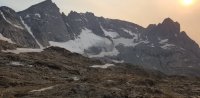
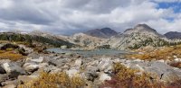
Knapsack Col! This glacial valley was AMAZING. I believe the mighty Green River begins here too.

Nice nose shot, right?

Incredible Granite peaks and ridges, massive glaciers, vertical snow shutes multiple waterfalls and high alpine meadows all in ONE photo!

This is a special place. I will be back again, hopefully without the smoke!

Climbing higher and looking back at the relentless smoke..

which at least allows for some very nice pics of the setting sun and silhouettes coming off the little camera lens on my smartphone.")
Sulfur Peak I think.
After Peak Lake I was bonking (hitting the wall) big time. Was it all the smoke combined with the altitude and heavy pack?

Soon I came across this little patch of glacial turf, normally covered in snow for most of the year. The ground here was soft and with plenty of fresh water.

This little "spot of turf" was around 11,700 feet, and with no danger of storms in the forecast that night or any clouds to speak of, hindsight I should have camped here for the night then gone over the Col the next morning. The views were incredible. Camping at 11,700 would have been a 1st for me, but..

I instead continued pushing and punishing myself as I made my goal of reaching the Col that day.

The sun had not set yet but was completely blocked out by smoke from the Hoback fire.


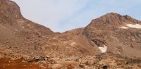
Finally reached Knapsack Col! The look on my face tells it all: Now I have to go down this thing (with only an hour of daylight left)!

What lay ahead of me: a massive glacial valley with nothing but boulder fields (after the glacier of course). I only had an hour of daylight left.

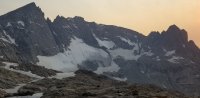
I did manage to take a few more pics in the fading light. Looking back at the Col and glacier. The glacier was solid ice and a little treacherous without spikes. Then the boulder fields, with NOWHERE to make a camp, and no trail to follow (if it exists I lost it in the dark). The only choice I had was to continue down.

To make things worse, a Gail-force wind picked up blowing up the valley I was trying to go down through. In the dark I had to scramble/stubble through 2.5 more miles of this with just a headlamp lighting up a few feet in front of me and the wind blowing me back. I crossed a large fast moving stream draining this glacial nightmare 3 times before I found a place to set up camp (3 hours later at upper Titcomb Lake). The last 2 hours SUCKED ROCKS!, lol..Finally had dinner at 10:30 that night before gratefully crawling in my sleeping bag. The dogs were tired too. That was a long day, over 12 hours of hiking and 15 miles.

Day #3
The wind blew all night and cleared out the smoke. It was a beautiful, calm morning. Neither me or the dogs stirred much till mid morning. Looking back at where we came from the night before. What you cannot see is glacial valley and the Col that are around the corner, left.

Hello Titcomb lake (upper).

I took it easy packing up and headed out of the Basin.
Lower Titcomb Lake.
And the people were there. This is the 2nd most popular destination in the Windrivers (the Cirque of the Towers is 1st).

Easily can see why. Looking back North.


Goodbye Titcomb. This day was going to be an easy one compared to the day before. No more off-trail, glacial field/boulder hopping hiking-in-the-dark for me!

The junction towards Indian Basin. Will visit that basin someday.

There are few unnamed lakes just South of Titcomb.


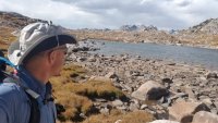
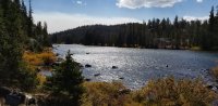
Island Lake.

Just past this beach I turned left as was soon off trail again, and gaining elevation. The beach would have been tempting the air temps were warmer than 50 degrees that day.

Looking back with a nice view of Island Lake as I was climbing, eventually going off trail towards Wall Lake.


with Elephant Head to the left

There was a bit of a trail now and then heading towards the pass which can be see in the background. Really enjoyed this area between Island Lake and Wall Lake. After Day #2 in Titcomb Basin I saw no one till I passed a few hunters on the last day (Day #5) of the trip.


I wondered how long this massive boulder has been sitting there, on top of the ridge.
 Looking back from where I came up. It was nice to finally see some clouds that were NOT SMOKE.

I came over the pass and glissaded down a small glacier on the other side. This time the snow was soft, not like the last glacier on the Col that was solid ice.
Having a great day, taking my time.

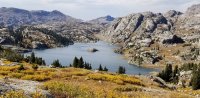
First view of Wall Lake.

A better view of Wall Lake. The name speaks for itself and I wondered how I was going to get around this lake tomorrow.

Unnamed lakes and Peak (at least on my map) above Wall Lake.


Looking back at what I came down. I chose the least-steep area, which ended up being a major bush wacking experience. Had I done it over I would have chosen the more steeper ascent around and in between the Granite.

After setting up camp the wind from the South again picked up as the sun set. I was hoping to fish this lake, I've heard there are some big ones here, but the wind made it not the best time to try any fishing.

Very much enjoyed watching the sunset light up the mountains around me.

Yes that is smoke coming in again over the gorgeous sunlight mountains of granite. That night while answering nature's call I again saw ash falling from the sky.

I believe this mountain peak is called Faler Tower.

Day #4
The wind was still blowing from the South.
I admit I was a little concerned how to get around this lake that was completely surrounded on three sides (South, West and East) by solid Granite. Looking back to the North side of the lake where I camped.

It turned out to be a worry-free, cairn-marked route through gentle sloped areas of granite. I soon reached the South-East side of the lake and heading East walked up and over another small pass as. There was a trail most of the way.

As I crested over the small pass heading towards Cook Lakes the wind suddenly was gone, and it was as calm as a spring morning. Crazy.

I was making my way towards the Fremont Trail, with the idea of heading up to Hat Pass then down to Lake Victor.

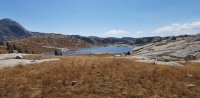
Cook Lakes. Now the Cold Font arrived, with clouds threatening rain or a rain/snow mix. It was much cooler - never getting above 40 degrees that day. Still beautiful though.

Pole Creek Lakes


The moment of decision: the junction of the Highline Trail and Fremont Trail. I was not liking the idea of climbing above treeline and up to another substantial pass being more exposed to threatening weather, so I changed plans - as often happens in this type of country. Instead of going East on the Fremont trail, I turned South on the Highline Trail towards Chain Lakes where the elevation is lower and relatively the same, meandering through trees and meadows, then after Lake George planned on turning north towards Lake Victor.
In a few hours I realized how fortunate I was to change routes.

The views were still very nice. I was enjoying going mostly downhill on this part of the trip.

This was the most challenging stream crossing (by Pole Creek Lakes) I had to cross. For September not bad, earlier in the season I'm sure more of a challenge.

Another junction. Most people going to and coming from Titcomb Basin pass through here coming from Elkhart Park. I saw no one that day, just me and the dogs.

More downhill meandering in the reverie.

Approaching the North end of Chain Lakes. It was nice not to have all the smoke - the cold front blew it all out.

Another lake in the Chain Lakes. Soon after MY BODY decided it was time to be done for the day - never had this happen before: instantly I had a severely pinched nerve on my upper right hip - so severe that I could no longer walk. All I could do is hobble over to the side of the lake and lay on the ground for a while and figure out what was going on with the right side of my SI joint. This most likely was from that very rough night of hiking down off Knapsack Cole through boulder fields for 2.5 hours which over strained my SI joint, showing up 2 days later.
For 30 minutes I could barely MOVE and THAT wasn't a good sign! I started texting my wife (through my Garmin INreach, via satellite) telling her she might be sending up horses and riders (from the ranch at Boulder Lake) to come get me. Eventually I was able to very slowly hobble to the North end Chain Lakes and find a good camp spot to set up my tent. Good thing I did not go the planned route towards Hat's Pass! I was a bit discouraged though..

When I opened up the front of my pack to setup camp, President Russell M Nelson was right there to greet and encourage me.
I immediately started to feel better!

After getting my tent setup, I decided to walk around the lake for a while and hopefully loosen/relax my back a bit..while fishing of course!
Now that the cold front had passed through, the weather was finally calm. The most calm it had been since the first day. It was COLD though..the temperature dropping fast as the sun set.

The fishing was awesome! These large trout (18 inchers) would hit my spinner hard, then jump out of the water trying to get rid of the hook - very fun catch and release that evening.


Because of the cold I soon went to bed, hoping and praying I could hike out the next day, a 15+ mile walk. I wasn't sure if I could do it but at least I had plenty of food and supplies for a couple of more days.

As the sun set to the west, you could see the solid plume of smoke in the distance, having been blown South by the front coming in. That night we heard more Elk bugling - and this time the dogs didn't freak out about it.

Day #5
Diesel valiantly guarding our camp as I packed up. The dogs loved chasing the chipmunks and squirrels NONSTOP.

Another smokey day.
Barnes Lake.

I was moving along nicely, although my lower back/right hip area reminded me to take it easy.
Nice open valley/meadow halfway between Barnes and Horseshoe Lakes.

I was in constant communication for the 1st 8 miles that day with my wife - I love the Garmin INreach! We both decided I could probably make it to the trail head on my own that day, so she left home to come and pick me up as I continued, taking it easy.
Horseshoe Lake.

This sign was as confusing on the trail as you see it here..

I made a little loop and checked out Lake George. Just North of this Lake I would have turned left on the Highline Trail to Lake Victor, had the SI joint not changed plans. Another time then.

A large part of this area was burned out 20 + years ago.

Coyote Lake.

Common sight in this area: burned out trees with small pines coming up.
Lovatt Lake.
The first glimpse of the valley towards Boulder Lake. Hard to see because of the smoke again. For about 3 miles I hiked along a mountain ridge going downhill - very enjoyable and my back continued to improve.


First glimpse of Blueberry Lake and Boulder Lake.

Boulder Lake and my Sweetie arriving there soon to pick me up. Only problem was 3 + more miles to go. A Zip Line anyone?

Blueberry Lake.

Thirsty dogs at Blueberry. So far that day I had walked 13 miles and dropped 1,300' in elevation with no major SI issues. Another 1,200' and 2 miles downhill to go!

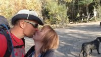
Made it! It was AWESOME to meet my wife there, who just arrived 30 minutes before and waiting for me.

60 + miles in 5 days. The dogs wasted no time to jump in the car and sleep all the way home.

The next time I do this trip (oh yes, there will be a next time..), it will be a month earlier, and will plan on climbing over Knapsack the morning of the 3rd day. Adding Lake Victor would definitely require at least 2 more days and another 20 miles. Sounds fun, doesn't it?
For those die-hards who want more info and are willing to watch a looong video of this trip:
I think this link takes you to it.
WARNING: a 1 hour and 50 minute video with NO music (still figuring that one out) and NO GUARANTEES you will be entertained by it whatsoever, especially with me narrating the whole thing. I.am.an.amature!
I had so much fun hiking the Winds in August, I wanted to do one more trip I had not yet done before: a thru-hike in the Northern part of the range starting at Green River Lakes, heading South to scale Knapsack Cole, visit Titcomb Basin, then on to Lake Victor and make my way to the Boulder Lake Trail Head, hopefully hearing the Elk bugle along the way. It was later in September (the 17th) than I wanted though, but the weather forecast looked mostly dry and my wife was willing to drop me off then later pick me up at Boulder Lake. I couldn't pass that up!
What actually happened Itinerary (it changed from the original plan):
Sept 17: Drive 6 hours to Green River Lakes, then boogie on the Highline Trail following the Green River to Three Forks Park before dark (11.5+ miles).
Sept 18: Climb to Vista Pass, then up to Cube Rock Pass, then up and over Knapsack Col then down into Titcomb Basin (a LONG DAY 15 miles).
Sept 19: Explore through Titcomb and further on to Island Lake, then off-trail to Wall Lake (9.5 miles).
Sept 20: Navigate around Wall Lake to Cook Lakes, then back on the Highline Trail heading South past Pole Creek Lakes to Chain Lakes (9 miles).
Sept 21: Continued South past Barnes Lake and Horseshoe Lake, checked out Lake George and Coyote Lake, then on the Ruff Lake Trail to the Boulder Lake Trailhead (15+ miles).
Pack ready to go: A full 85 Liter pack for this trip with gear including 17 lbs of food for 6 full days and 10 extra pounds of clothing and sleeping gear (than I normally carry) for the colder weather (temps dropping in the low 20's), gear for rain/snow, plus 2 closed-cell sleeping pads for my dogs to help them stay warm at night. 50 + lbs!
Day #1
My dear wife dropping me off at Green River Lakes and sending me off.
I started around 2:30 pm that 1st day. It was the warmest and nicest day of the trip. SMOKEY, but bug free.
Square Top Mountain was ahead of me for the 1st 3 miles. Hazy, but gorgeous.
The aspens that grow in the lower elevations (8,500' or lower) showing their fall-colored glory.
The trail that day followed the Green River the entire way including Three Forks Park were I camped that 1st night. After passing Square Top, I did not see another person till Day #3 in Titcomb Basin.
Just past Square Top I was impressed by this well built foot bridge crossing the Green River. Even this late in the year the Green River this far up in the Winds was full of water. Grateful to keep my feet dry.
Just a few days before a huge fire started 40 miles away at Hoback Junction that would plague me with smoke most of the trip. The pic below looks like the sun has gone down, but it was 4 in the afternoon with the sun up and blocked by the smoke. I would occasionally see ash falling out of the sky. A little eerie to experience. Still happy to be there!
I made it to Three Forks Park just as the sun was setting. For a few minutes the smoke cleared a bit, allowing a few stellar sun setting pics.
The dogs still have their summer coats, so to help them (especially the lab) not freeze at night they brought along their own very fashionable (I found the sweaters on clearance at Walmart a few years ago for cheap) dog sweaters. They never acted too put-out by them.
That night we woke up hearing our 1st Elk bugle in the wild - around 2am. The dogs were not familiar with that sound and were freaking out and I almost didn't stop them from taking off in the middle of the night after the Elk, but they settled down quickly and we went back to sleep. Way cool to hear the Elk!
Day #2
The night before it actually rained for about 20 minutes and the first part of the day was fairly clear of smoke, and much cooler. From this point I would ascend 4,000 vertical feet for the next 12 miles.
View of Three Forks Park looking South.
Very nice fall colors even on the switchbacks.
This junction sign was a little confusing and was grateful for my Garmin GPS. I headed towards "Elbow Lake".
Not long after this sign made much more sense and I turned here towards Vista Pass.
Vista Pass, and a nice place to camp if need be, but I continued on towards Dale Lake. The weather so far was cool and perfect for backpacking, gaining elevation the entire route so far.
After Vista Pass, you DROP elevation for a while, and I was not very excited losing altitude. I must admit though the views and solitude took away any disappointments of losing elevation.
Looking back into the glacial valley of the Green River were I camped the night before.
From here the trail is not maintained and disappears completely while navigating uphill through massive boulders and boulder fields. This is what was ahead of me.
In the last 24 hours hauling a 50+ pack, hiking 16+ miles, climbing over 2,000 feet I was beginning to feel it, which surprised me little. The last 4.5 miles took me over 3 hours - very slow for me. I think this pic tells it all how I was feeling..
I really wanted to ascend the Col that day, so I dropped my pack, took off the dogs' packs which Diesel (the Lab) was happy to be rid of..
and chilled for an hour while eating copious amounts of high-energy (calories and protein) foods..
While enjoying the view, and sunshine.
Now it was boulder hopping/scrambling/try-not-to-fall-or-injure-yourself/climbing. Slow going to say the least.
See the small area of "green" grass in the background past the boulder field? Going from there to were this picture was taken took 45 minutes!
Soon we headed left just past were Ollie (the dog) is and in classic Windriver fashion the scenery abrupt changed:
Dale Lake and Stroud Peak.
Walking past Dale Lake towards Cube Rock Pass. Is this the "Cube"?
Looking back over Dale Lake. I was awestruck with the views around me.
Peak Lake with Split Mountain in the background. Many camp here for the night and THEN ascend Knapsack Cole, but I had at least 4 hours of daylight and was determined to reach the Col so I continued on around the lake (to the left).
Finally I could see Knapsack Col for the first time.
This is looking North over the outlet of Peak Lake feeding this little body of water. The smoke was coming back in.
Stroud Peak towering above Peak Lake.
Looking back at Cube Rock Pass. Not much of a pass, really. But maybe at this elevation any amount of elevation gain and loss counts for a "pass"?
Knapsack Col! This glacial valley was AMAZING. I believe the mighty Green River begins here too.
Nice nose shot, right?
Incredible Granite peaks and ridges, massive glaciers, vertical snow shutes multiple waterfalls and high alpine meadows all in ONE photo!
This is a special place. I will be back again, hopefully without the smoke!
Climbing higher and looking back at the relentless smoke..
which at least allows for some very nice pics of the setting sun and silhouettes coming off the little camera lens on my smartphone.
Sulfur Peak I think.
After Peak Lake I was bonking (hitting the wall) big time. Was it all the smoke combined with the altitude and heavy pack?
Soon I came across this little patch of glacial turf, normally covered in snow for most of the year. The ground here was soft and with plenty of fresh water.
This little "spot of turf" was around 11,700 feet, and with no danger of storms in the forecast that night or any clouds to speak of, hindsight I should have camped here for the night then gone over the Col the next morning. The views were incredible. Camping at 11,700 would have been a 1st for me, but..
I instead continued pushing and punishing myself as I made my goal of reaching the Col that day.
The sun had not set yet but was completely blocked out by smoke from the Hoback fire.
Finally reached Knapsack Col! The look on my face tells it all: Now I have to go down this thing (with only an hour of daylight left)!
What lay ahead of me: a massive glacial valley with nothing but boulder fields (after the glacier of course). I only had an hour of daylight left.
I did manage to take a few more pics in the fading light. Looking back at the Col and glacier. The glacier was solid ice and a little treacherous without spikes. Then the boulder fields, with NOWHERE to make a camp, and no trail to follow (if it exists I lost it in the dark). The only choice I had was to continue down.
To make things worse, a Gail-force wind picked up blowing up the valley I was trying to go down through. In the dark I had to scramble/stubble through 2.5 more miles of this with just a headlamp lighting up a few feet in front of me and the wind blowing me back. I crossed a large fast moving stream draining this glacial nightmare 3 times before I found a place to set up camp (3 hours later at upper Titcomb Lake). The last 2 hours SUCKED ROCKS!, lol..Finally had dinner at 10:30 that night before gratefully crawling in my sleeping bag. The dogs were tired too. That was a long day, over 12 hours of hiking and 15 miles.
Day #3
The wind blew all night and cleared out the smoke. It was a beautiful, calm morning. Neither me or the dogs stirred much till mid morning. Looking back at where we came from the night before. What you cannot see is glacial valley and the Col that are around the corner, left.
Hello Titcomb lake (upper).
I took it easy packing up and headed out of the Basin.
Lower Titcomb Lake.
And the people were there. This is the 2nd most popular destination in the Windrivers (the Cirque of the Towers is 1st).
Easily can see why. Looking back North.
Goodbye Titcomb. This day was going to be an easy one compared to the day before. No more off-trail, glacial field/boulder hopping hiking-in-the-dark for me!
The junction towards Indian Basin. Will visit that basin someday.
There are few unnamed lakes just South of Titcomb.
Island Lake.
Just past this beach I turned left as was soon off trail again, and gaining elevation. The beach would have been tempting the air temps were warmer than 50 degrees that day.
Looking back with a nice view of Island Lake as I was climbing, eventually going off trail towards Wall Lake.
with Elephant Head to the left
There was a bit of a trail now and then heading towards the pass which can be see in the background. Really enjoyed this area between Island Lake and Wall Lake. After Day #2 in Titcomb Basin I saw no one till I passed a few hunters on the last day (Day #5) of the trip.
I wondered how long this massive boulder has been sitting there, on top of the ridge.
Looking back from where I came up. It was nice to finally see some clouds that were NOT SMOKE.I came over the pass and glissaded down a small glacier on the other side. This time the snow was soft, not like the last glacier on the Col that was solid ice.
Having a great day, taking my time.
First view of Wall Lake.
A better view of Wall Lake. The name speaks for itself and I wondered how I was going to get around this lake tomorrow.
Unnamed lakes and Peak (at least on my map) above Wall Lake.
Looking back at what I came down. I chose the least-steep area, which ended up being a major bush wacking experience. Had I done it over I would have chosen the more steeper ascent around and in between the Granite.
After setting up camp the wind from the South again picked up as the sun set. I was hoping to fish this lake, I've heard there are some big ones here, but the wind made it not the best time to try any fishing.
Very much enjoyed watching the sunset light up the mountains around me.
Yes that is smoke coming in again over the gorgeous sunlight mountains of granite. That night while answering nature's call I again saw ash falling from the sky.
I believe this mountain peak is called Faler Tower.
Day #4
The wind was still blowing from the South.
I admit I was a little concerned how to get around this lake that was completely surrounded on three sides (South, West and East) by solid Granite. Looking back to the North side of the lake where I camped.
It turned out to be a worry-free, cairn-marked route through gentle sloped areas of granite. I soon reached the South-East side of the lake and heading East walked up and over another small pass as. There was a trail most of the way.
As I crested over the small pass heading towards Cook Lakes the wind suddenly was gone, and it was as calm as a spring morning. Crazy.
I was making my way towards the Fremont Trail, with the idea of heading up to Hat Pass then down to Lake Victor.
Cook Lakes. Now the Cold Font arrived, with clouds threatening rain or a rain/snow mix. It was much cooler - never getting above 40 degrees that day. Still beautiful though.
Pole Creek Lakes
The moment of decision: the junction of the Highline Trail and Fremont Trail. I was not liking the idea of climbing above treeline and up to another substantial pass being more exposed to threatening weather, so I changed plans - as often happens in this type of country. Instead of going East on the Fremont trail, I turned South on the Highline Trail towards Chain Lakes where the elevation is lower and relatively the same, meandering through trees and meadows, then after Lake George planned on turning north towards Lake Victor.
In a few hours I realized how fortunate I was to change routes.
The views were still very nice. I was enjoying going mostly downhill on this part of the trip.
This was the most challenging stream crossing (by Pole Creek Lakes) I had to cross. For September not bad, earlier in the season I'm sure more of a challenge.
Another junction. Most people going to and coming from Titcomb Basin pass through here coming from Elkhart Park. I saw no one that day, just me and the dogs.
More downhill meandering in the reverie.
Approaching the North end of Chain Lakes. It was nice not to have all the smoke - the cold front blew it all out.
Another lake in the Chain Lakes. Soon after MY BODY decided it was time to be done for the day - never had this happen before: instantly I had a severely pinched nerve on my upper right hip - so severe that I could no longer walk. All I could do is hobble over to the side of the lake and lay on the ground for a while and figure out what was going on with the right side of my SI joint. This most likely was from that very rough night of hiking down off Knapsack Cole through boulder fields for 2.5 hours which over strained my SI joint, showing up 2 days later.
For 30 minutes I could barely MOVE and THAT wasn't a good sign! I started texting my wife (through my Garmin INreach, via satellite) telling her she might be sending up horses and riders (from the ranch at Boulder Lake) to come get me. Eventually I was able to very slowly hobble to the North end Chain Lakes and find a good camp spot to set up my tent. Good thing I did not go the planned route towards Hat's Pass! I was a bit discouraged though..
When I opened up the front of my pack to setup camp, President Russell M Nelson was right there to greet and encourage me.
I immediately started to feel better!
After getting my tent setup, I decided to walk around the lake for a while and hopefully loosen/relax my back a bit..while fishing of course!
Now that the cold front had passed through, the weather was finally calm. The most calm it had been since the first day. It was COLD though..the temperature dropping fast as the sun set.
The fishing was awesome! These large trout (18 inchers) would hit my spinner hard, then jump out of the water trying to get rid of the hook - very fun catch and release that evening.
Because of the cold I soon went to bed, hoping and praying I could hike out the next day, a 15+ mile walk. I wasn't sure if I could do it but at least I had plenty of food and supplies for a couple of more days.
As the sun set to the west, you could see the solid plume of smoke in the distance, having been blown South by the front coming in. That night we heard more Elk bugling - and this time the dogs didn't freak out about it.
Day #5
Diesel valiantly guarding our camp as I packed up. The dogs loved chasing the chipmunks and squirrels NONSTOP.
Another smokey day.
Barnes Lake.
I was moving along nicely, although my lower back/right hip area reminded me to take it easy.
Nice open valley/meadow halfway between Barnes and Horseshoe Lakes.
I was in constant communication for the 1st 8 miles that day with my wife - I love the Garmin INreach! We both decided I could probably make it to the trail head on my own that day, so she left home to come and pick me up as I continued, taking it easy.
Horseshoe Lake.
This sign was as confusing on the trail as you see it here..
I made a little loop and checked out Lake George. Just North of this Lake I would have turned left on the Highline Trail to Lake Victor, had the SI joint not changed plans. Another time then.
A large part of this area was burned out 20 + years ago.
Coyote Lake.
Common sight in this area: burned out trees with small pines coming up.
Lovatt Lake.
The first glimpse of the valley towards Boulder Lake. Hard to see because of the smoke again. For about 3 miles I hiked along a mountain ridge going downhill - very enjoyable and my back continued to improve.
First glimpse of Blueberry Lake and Boulder Lake.
Boulder Lake and my Sweetie arriving there soon to pick me up. Only problem was 3 + more miles to go. A Zip Line anyone?
Blueberry Lake.
Thirsty dogs at Blueberry. So far that day I had walked 13 miles and dropped 1,300' in elevation with no major SI issues. Another 1,200' and 2 miles downhill to go!
Made it! It was AWESOME to meet my wife there, who just arrived 30 minutes before and waiting for me.
60 + miles in 5 days. The dogs wasted no time to jump in the car and sleep all the way home.
The next time I do this trip (oh yes, there will be a next time..), it will be a month earlier, and will plan on climbing over Knapsack the morning of the 3rd day. Adding Lake Victor would definitely require at least 2 more days and another 20 miles. Sounds fun, doesn't it?
For those die-hards who want more info and are willing to watch a looong video of this trip:
WARNING: a 1 hour and 50 minute video with NO music (still figuring that one out) and NO GUARANTEES you will be entertained by it whatsoever, especially with me narrating the whole thing. I.am.an.amature!
Attachments
-
 20180918_173928.jpg254.9 KB · Views: 13
 -
 20180918_173934.jpg342.3 KB · Views: 11
 -
 20180918_173938.jpg156.4 KB · Views: 11
 -
 20180918_181352.jpg194.9 KB · Views: 11
 -
 20180919_143933.jpg316.4 KB · Views: 11
 -
 20180919_152508.jpg423.8 KB · Views: 10
 -
 20180919_155022.jpg311.2 KB · Views: 11
 -
 20180919_185202.jpg269.3 KB · Views: 11
 -
 20180920_124150.jpg373.2 KB · Views: 13
 -
 20180920_143405.jpg338 KB · Views: 11
 -
 20180921_131453.jpg502.4 KB · Views: 11
 -
 20180921_172252.jpg289.8 KB · Views: 10
 -
 20181016_155828.jpg469.1 KB · Views: 14
 -
 20181016_193705.jpg376.4 KB · Views: 13
Last edited: