Joey
walking somewhere
- Joined
- Apr 1, 2014
- Messages
- 878
This is a trip report from a 4 day backpack I did recently in Colorado's Maroon Bell-Snowmass Wilderness. Just a few miles outside the town of Aspen, this route is commonly referred to as the Four Pass Loop, combining 4 different high mountain passes with a few spectacular lakes over a 28 mile stretch of trail. There really isn't much of a story to this trip, as I took my time and just enjoyed being out there. The scenery was spectacular though, and this was one of my favorite trips of the year.

Here is the route I took:
Click here to view on CalTopo
This trip pretty much came out of nowhere. It was mid October, and I was working in the town of Jackson, Wyoming. I had planned to spend all of October in the Yellowstone backcountry, but the weather this fall (2016) was rainy and snowy, more so than the last several years. I wasn't surprised, since this entire year for me has been stormy. I started looking at other options, and noticed Colorado had a great weather forecast. Although I've visited Colorado a few times, I had never backpacked there. It seemed like the perfect time to go. So I headed south, not really sure what I was going to do. I stopped at an outdoor shop, bought a few maps, and then sat in my van for a few hours trying to figure out where to go. The Maroon Bells seemed to be the easiest option for a multi day loop, plus it was easy to drive to. Since it was October, I figured it wouldn't be crowded like it normally is in the summer months. So I drove to the Maroon Lake Trailhead in the dark, and slept in the van.
Originally, my plan was to backpack for an entire week, so I carried in 7 days of food. I wasn't sure which route I was going to take, but it looked like I had multiple options. I was primarily looking at doing a figure 8 loop, including either Capitol Lake or Pierre Lakes Basin in the mix. But due to more camera issues, and overcast, windy days, I shortened it to the standard loop, doing it easily in 4 days. Some people trail run this entire route in a day, and it could definitely be done much faster than I did it.
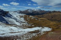
Day 1: I woke up to numerous cars pulling into the trailhead at Maroon Lake. I was surprised to see so many people for mid October. I took my time getting packed, and hit the trail around noon. I probably passed 200 people as I walked past Maroon Lake up to Crater Lake. Maroon Lake was spectacular, but Crater Lake really wasn't much to look at. There was hardly any water in it. From there, I headed south west up the West Maroon Creek Trail. The crowds thinned out from here, and I would only see a handful of people the rest of the trip. I slowly worked my way up the valley, which was surrounded by beautiful, snow dusted mountains. It looked like fall, as most of the vegetation was red or brown, and the grass yellow. Unfortunately, I just missed the yellow leaves on the Aspen trees, which had already fallen off by this point. With the exception of the first mile, the entire route is above 10,000 feet. Although I'm used to high elevations, I did notice that I had to stop more than normal to breath. I wasn't in a hurry, and eventually made camp about a mile below West Maroon Pass. The temperatures were pretty mild, but it was extremely windy, and there was definitely a wind chill effect. I also forgot to pack my tent stakes. I spent the night listening to my tent flap in the wind, hoping I didn't blow away. I did have great views of the valley, and almost a full moon.

Maroon Lake

Sievers Mountain

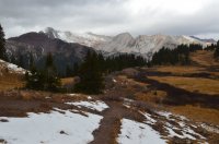
Looking up the West Maroon Creek drainage. Crater Lake is the large meadow.

The trail around Crater Lake.


Behind me you can see Crater Lake to the right, along with the big meadows around it. Up in the left hand corner is where I come back to finish the loop.


Hiking up the trail.


Almost to camp.


Views of my camp on night one. About a mile below West Maroon Pass.

Food for 7 days. With a shortened trip, I never got hungry.

Evening light hitting the peaks of the ridge line above camp.
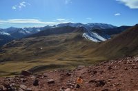
Day 2: I woke up to another beautiful, windy day. Since the sun doesn't rise above the peaks until after 8 am, I stayed in the tent for a while. Then I spent a few hours in camp, just enjoying the views. It was close to noon again when I finally packed up and hit the trail. I headed up and over West Maroon Pass, which had a minimal amount of snow on it, and then dropped down into a beautiful, open sloped basin. I slowly made my way towards Frigid Air Pass, and climbed over that before dropping down into Fravert Basin. The views from Frigid Air Pass, along with everywhere else along the trail, were really beautiful. The depth of the mountains was incredible, and something that really stood out to me the entire trip. Everywhere I looked, all I could see was more mountains. It reminded me of the Canadian Rockies in British Columbia, although not quite as dramatic. I felt engulfed, and I love that. It was getting dark on me quickly, so I decided to make camp along the creek in the basin. I tied guy lines to willow bushes, and spent another night listening to my tent flop in the wind.


Views from camp in the morning.
 Hitting the trail in the morning. West Maroon Pass is visible in the top right.

My camp had been down in front of those trees, overlooking the valley.


You can see the trail going up to the pass.

Almost to the pass. Not much snow to deal with.

Me at West Maroon Pass, the East Fork drainage behind me.


Views from the pass in the direction I had hiked up from.

Views in front of me as I head down the trail.


Looking down the East Fork drainage towards Elko Park.

Heading towards Frigid Air Pass.


Looking up at Frigid Air Pass, which is directly above the trail junction sign.


Views from Frigid Air Pass

Dropping down snowy switchbacks


Views as I hiked down into Fravert Basin


Views of camp night number two in Fravert Basin
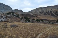
Day 3: This was the day I began to realize I was going to cut my trip short. I woke up to overcast skies, and snow flurries fell through out the day. I got another late start, and headed down the North Fork trail. The fall colors really stood out as I hiked through several large meadows. The green of evergreen trees really contrasted with the brown, red, and yellow colors of everything else. I took the cut off trail towards Trail Rider Pass, which climbs up much more steeply than the map shows it doing. Along the way I found a bottle of Jameson lying in the trail, with quite a bit of whiskey still inside. I stared at it for a while, like a fish starring at bait on a hook. I have a bigger brain though, and decided against drinking random whiskey is a bottle. The views continued to be spectacular as I made my way up to the pass. At the top, I had my first view of Snowmass Lake. The wind was extremely strong, so I quickly made my way down to the lake. I set up my tent in heavy forest along the outlet stream. Then I spent the evening sitting at the lake shore, enjoying the view for as long as I could, well past dark. Although it was cloudy, the moon popped out a few times, lighting up the lake and surrounding mountain walls. I think Snowmass Lake was the highlight of the trip, and one of the prettiest places I visited this year. I was the only person there too. In fact, I didn't see any people the entire day.

Hitting the trail in the morning, with Fravert Basin behind me.

Looking down the valley, in the direction I was heading.

One of several waterfalls along the trail.

I love the colors in this shot, looking up at an un-named peak.

Hiking down the drainage.

Another waterfall.

I loved the colors along this tiny stream.

Hiking though meadows.


This is where I crossed the creek.

Looking back where I came from. Fravert Basin is up above the wooded ridge line on the left.


Too good to be true? I felt it was a set up.

Hiking up out of the meadows.

More views as I climb up.

Near the trail junction with the Geneva Lake trail.


Here you can see Trail Rider Pass, and the trail going up to it.

A small pond in the basin below the pass.

I love the color contrast with the dead grass here.

The final approach to Trail Rider Pass.


The views from Trail Rider Pass looking back where I came from.

My first view of Snowmass Lake.


Looking back towards the pass, which is out of sight to the left.

Another one of those shots where I love the fall color contrast.

Getting closer to Snowmass Lake.

Trail view.

Snowmass Lake

My tent in the trees. Finally a wind free night.

Snowmass Lake. I sat in the dark here for several hours, and was still able to see the lake. Awesomeness!
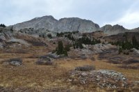
Day 4: I woke up much earlier than usual, with more overcast skies and snow flurries. I packed up camp, and headed towards Buckskin Pass and Maroon Lake. I passed a pretty extensive beaver dam along the way. I kept thinking it was going to storm on me, but it never did. This was the coldest day of the trip. Buckskin Pass was another awesome spot. From there I dropped down a couple thousand feet, and made my way back to the trailhead. There was far less people at the lake this time than when I had started.

A side view of Snowmass Lake

A waterfall just below the foot of the lake.

Trail junction sign.

Heading towards Buckskin Pass

Ice on the pond.

The cool beaver dam

A closer look.


Trail shots of me climbing up to the pass.

Me at Buckskin Pass.


Views from the pass.


Love this shot hiking down towards Crater Lake.


A beautiful view looking up West Maroon Creek, the way I went on day 1. Crater Lake is out of sight to the left.

Leave-less Aspens

Almost done.

Maroon Lake.
Pretty cool and fun solo trip. I loved this place. I've avoided Colorado for years because of how many people live and hike there. Plus I didn't think it would feel wild enough for me. I was especially apprehensive about going near Aspen. But I loved it, and had a great trip. I'm not sure if I would like it during the summer when it is much more crowded. One thing that really stood out to me was how friendly everyone on the trail was. I enjoyed talking with several people, and everyone here seemed to be happy. As I mentioned earlier, another thing that really stood out was the depth and vastness of the mountains. I love being up high, and seeing an endless sea of peaks and mountains. I'll be spending a few more weeks in Colorado next year.
The End.")
Here is the route I took:
Click here to view on CalTopo
This trip pretty much came out of nowhere. It was mid October, and I was working in the town of Jackson, Wyoming. I had planned to spend all of October in the Yellowstone backcountry, but the weather this fall (2016) was rainy and snowy, more so than the last several years. I wasn't surprised, since this entire year for me has been stormy. I started looking at other options, and noticed Colorado had a great weather forecast. Although I've visited Colorado a few times, I had never backpacked there. It seemed like the perfect time to go. So I headed south, not really sure what I was going to do. I stopped at an outdoor shop, bought a few maps, and then sat in my van for a few hours trying to figure out where to go. The Maroon Bells seemed to be the easiest option for a multi day loop, plus it was easy to drive to. Since it was October, I figured it wouldn't be crowded like it normally is in the summer months. So I drove to the Maroon Lake Trailhead in the dark, and slept in the van.
Originally, my plan was to backpack for an entire week, so I carried in 7 days of food. I wasn't sure which route I was going to take, but it looked like I had multiple options. I was primarily looking at doing a figure 8 loop, including either Capitol Lake or Pierre Lakes Basin in the mix. But due to more camera issues, and overcast, windy days, I shortened it to the standard loop, doing it easily in 4 days. Some people trail run this entire route in a day, and it could definitely be done much faster than I did it.
Day 1: I woke up to numerous cars pulling into the trailhead at Maroon Lake. I was surprised to see so many people for mid October. I took my time getting packed, and hit the trail around noon. I probably passed 200 people as I walked past Maroon Lake up to Crater Lake. Maroon Lake was spectacular, but Crater Lake really wasn't much to look at. There was hardly any water in it. From there, I headed south west up the West Maroon Creek Trail. The crowds thinned out from here, and I would only see a handful of people the rest of the trip. I slowly worked my way up the valley, which was surrounded by beautiful, snow dusted mountains. It looked like fall, as most of the vegetation was red or brown, and the grass yellow. Unfortunately, I just missed the yellow leaves on the Aspen trees, which had already fallen off by this point. With the exception of the first mile, the entire route is above 10,000 feet. Although I'm used to high elevations, I did notice that I had to stop more than normal to breath. I wasn't in a hurry, and eventually made camp about a mile below West Maroon Pass. The temperatures were pretty mild, but it was extremely windy, and there was definitely a wind chill effect. I also forgot to pack my tent stakes. I spent the night listening to my tent flap in the wind, hoping I didn't blow away. I did have great views of the valley, and almost a full moon.
Maroon Lake
Sievers Mountain
Looking up the West Maroon Creek drainage. Crater Lake is the large meadow.
The trail around Crater Lake.
Behind me you can see Crater Lake to the right, along with the big meadows around it. Up in the left hand corner is where I come back to finish the loop.
Hiking up the trail.
Almost to camp.
Views of my camp on night one. About a mile below West Maroon Pass.
Food for 7 days. With a shortened trip, I never got hungry.
Evening light hitting the peaks of the ridge line above camp.
Day 2: I woke up to another beautiful, windy day. Since the sun doesn't rise above the peaks until after 8 am, I stayed in the tent for a while. Then I spent a few hours in camp, just enjoying the views. It was close to noon again when I finally packed up and hit the trail. I headed up and over West Maroon Pass, which had a minimal amount of snow on it, and then dropped down into a beautiful, open sloped basin. I slowly made my way towards Frigid Air Pass, and climbed over that before dropping down into Fravert Basin. The views from Frigid Air Pass, along with everywhere else along the trail, were really beautiful. The depth of the mountains was incredible, and something that really stood out to me the entire trip. Everywhere I looked, all I could see was more mountains. It reminded me of the Canadian Rockies in British Columbia, although not quite as dramatic. I felt engulfed, and I love that. It was getting dark on me quickly, so I decided to make camp along the creek in the basin. I tied guy lines to willow bushes, and spent another night listening to my tent flop in the wind.
Views from camp in the morning.
Hitting the trail in the morning. West Maroon Pass is visible in the top right.My camp had been down in front of those trees, overlooking the valley.
You can see the trail going up to the pass.
Almost to the pass. Not much snow to deal with.
Me at West Maroon Pass, the East Fork drainage behind me.
Views from the pass in the direction I had hiked up from.
Views in front of me as I head down the trail.
Looking down the East Fork drainage towards Elko Park.
Heading towards Frigid Air Pass.
Looking up at Frigid Air Pass, which is directly above the trail junction sign.
Views from Frigid Air Pass
Dropping down snowy switchbacks
Views as I hiked down into Fravert Basin
Views of camp night number two in Fravert Basin
Day 3: This was the day I began to realize I was going to cut my trip short. I woke up to overcast skies, and snow flurries fell through out the day. I got another late start, and headed down the North Fork trail. The fall colors really stood out as I hiked through several large meadows. The green of evergreen trees really contrasted with the brown, red, and yellow colors of everything else. I took the cut off trail towards Trail Rider Pass, which climbs up much more steeply than the map shows it doing. Along the way I found a bottle of Jameson lying in the trail, with quite a bit of whiskey still inside. I stared at it for a while, like a fish starring at bait on a hook. I have a bigger brain though, and decided against drinking random whiskey is a bottle. The views continued to be spectacular as I made my way up to the pass. At the top, I had my first view of Snowmass Lake. The wind was extremely strong, so I quickly made my way down to the lake. I set up my tent in heavy forest along the outlet stream. Then I spent the evening sitting at the lake shore, enjoying the view for as long as I could, well past dark. Although it was cloudy, the moon popped out a few times, lighting up the lake and surrounding mountain walls. I think Snowmass Lake was the highlight of the trip, and one of the prettiest places I visited this year. I was the only person there too. In fact, I didn't see any people the entire day.
Hitting the trail in the morning, with Fravert Basin behind me.
Looking down the valley, in the direction I was heading.
One of several waterfalls along the trail.
I love the colors in this shot, looking up at an un-named peak.
Hiking down the drainage.
Another waterfall.
I loved the colors along this tiny stream.
Hiking though meadows.
This is where I crossed the creek.
Looking back where I came from. Fravert Basin is up above the wooded ridge line on the left.
Too good to be true? I felt it was a set up.
Hiking up out of the meadows.
More views as I climb up.
Near the trail junction with the Geneva Lake trail.
Here you can see Trail Rider Pass, and the trail going up to it.
A small pond in the basin below the pass.
I love the color contrast with the dead grass here.
The final approach to Trail Rider Pass.
The views from Trail Rider Pass looking back where I came from.
My first view of Snowmass Lake.
Looking back towards the pass, which is out of sight to the left.
Another one of those shots where I love the fall color contrast.
Getting closer to Snowmass Lake.
Trail view.
Snowmass Lake
My tent in the trees. Finally a wind free night.
Snowmass Lake. I sat in the dark here for several hours, and was still able to see the lake. Awesomeness!
Day 4: I woke up much earlier than usual, with more overcast skies and snow flurries. I packed up camp, and headed towards Buckskin Pass and Maroon Lake. I passed a pretty extensive beaver dam along the way. I kept thinking it was going to storm on me, but it never did. This was the coldest day of the trip. Buckskin Pass was another awesome spot. From there I dropped down a couple thousand feet, and made my way back to the trailhead. There was far less people at the lake this time than when I had started.
A side view of Snowmass Lake
A waterfall just below the foot of the lake.
Trail junction sign.
Heading towards Buckskin Pass
Ice on the pond.
The cool beaver dam
A closer look.
Trail shots of me climbing up to the pass.
Me at Buckskin Pass.
Views from the pass.
Love this shot hiking down towards Crater Lake.
A beautiful view looking up West Maroon Creek, the way I went on day 1. Crater Lake is out of sight to the left.
Leave-less Aspens
Almost done.
Maroon Lake.
Pretty cool and fun solo trip. I loved this place. I've avoided Colorado for years because of how many people live and hike there. Plus I didn't think it would feel wild enough for me. I was especially apprehensive about going near Aspen. But I loved it, and had a great trip. I'm not sure if I would like it during the summer when it is much more crowded. One thing that really stood out to me was how friendly everyone on the trail was. I enjoyed talking with several people, and everyone here seemed to be happy. As I mentioned earlier, another thing that really stood out was the depth and vastness of the mountains. I love being up high, and seeing an endless sea of peaks and mountains. I'll be spending a few more weeks in Colorado next year.
The End.
 I once took a hit off a bottle of Fireball that I found at an abandoned cabin in the Mojave.
.jpg")