Backpacking Canyonlands The Maze, April 2025

I looked at that too. I knew getting to the overlook was going to be pushing it in terms of time, but seeing that sealed the deal and dropped it from consideration. My son the climber would have been fine, but I've gotten a bit more cautious these days!
Even if you don't think you'll have the time or desire to climb all the way up to the top, I will say the bottom part of the Overlook hike is still super fun (we had a blast doing it even though we ended up turning back at that point).

Regarding which canyon to exit out of--all of the options are scenic and of kind of similar difficulty (I haven't done the Plug yet--we were planning on it last time, but had to cut a day off our trip due to incoming weather for the drive home). I don't recall the S. Fork Horse Canyon exit being harder than the SE Fork of Pictograph Canyon--in fact, I think it was probably a little easier. All of them are probably enough to feel a little exciting for you but all of them are way easier than the Maze Overlook in my opinion. It's a way longer hike through S. Fork though from the Harvest Scene. S. Fork has more water and has a more serene/pristine feel (really feels like nobody goes there), as TrailScot said, but I think it's also less spectacular (the walls aren't as tall, etc--although that's of course a matter of opinion). If you're pressed for time, the SE Fork Of Picto Canyon would be a great choice to consider--that's what I'd do if I had a short amount of time.
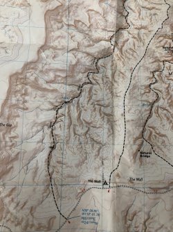
Thanks for the great info Ryan and for the recommendations. Perhaps biting off some of the overlook trail and then exiting via Picto would be a good alternative...plenty scenic but not as many miles as Horse. Don't know if I'll ever make it back there, so trying to make the most of the time we'll have.
 
Many thanks for adding your input. With the advice I've gotten I think the South Fork will be our planned day 2 exit after an early wake-up and seeing the panel. Regarding the climb out...is the trail easy to follow and without significant "sketchy" spots? It looks relatively short and direct on the map, I have too, just following the westernmost arm until it reaches the maintained trail, but from your description it sounds like that's not the case. Again thanks, I really appreciate the first-hand knowledge. View attachment 142062
The hike out does not have any "Sketchy" parts. Just a steep initial push to get up to the height of the rock shelf layers, then it just meanders around a couple of times. Just keep an eye on cairns and your map shows the route much more clear than mine. As you can see my map shows a straight line as its a Nat Geo map from 2008. Have fun out there!IMG_6048.jpeg
 
The hike out does not have any "Sketchy" parts. Just a steep initial push to get up to the height of the rock shelf layers, then it just meanders around a couple of times. Just keep an eye on cairns and your map shows the route much more clear than mine. As you can see my map shows a straight line as its a Nat Geo map from 2008. Have fun out there!View attachment 142227

I found the S Fk to be highly scenic. Looking at the above map, note two near equal forks at the head. Just north of those two is a smaller shorter fork heading SE. My memory is the route enters this and ascends to a wide ledge. It then holds that height heading around the point between it and the two headwater forks as @Mikjik86 says. When it enters that third (SW most) fork it climbs out it near where the marked trail leaves it. We saw cairns and tread frequently enough to not be concerned. There was some unusual rock art in the fork I found intriguing.
 
Last edited:
I found the S Fk to be highly scenic. Looking at the above map, note two near equal forks at the head. Just north of those two is a smaller shorter fork heading SE. My memory is the route enters this and ascends to a wide ledge. It then holds that height heading around the point between it and the two headwater forks as @Mikjik86 says. When it enters that third (SW most) fork it climbs out it near where the marked trail leaves it. We saw cairns and tread frequently enough to not be concerned. There was some unusual rock art in the fork I found intriguing.
Thanks for your input John. Since seeing the rock art is the impetus for this trip knowing that there's stuff worth seeing in the S. Fork might make taking on those extra miles worth the effort. I think the map I posted mirrors your description of the canyon exit. Regardless, it's good to know it's marked and well traveled.
 

Don't like ads? Become a BCP Supporting Member and kiss them all goodbye. Click here for more info.

Back
Top