Seldom Seen Anderson
Member
- Joined
- Jan 19, 2012
- Messages
- 739

I remembered Bill wrote in one of his TR's Ashdown was one of the best hikes in Utah. Ever since reading this, several years ago, I have wanted to hike Ashdown. Finally I was able to last week. Knowing because of the landslide the exit might be closed I called Cedar Breaks to ask their opinion. They informed me that it should be no problem, I could drop off my pick up vehicle right before the construction but they did not inform me of the absolute chaos and dangerous conditions the landslide created and the ongoing construction made (more on that later).
We started hiking at 9:30 AM and I am glad we didnt start earlier. Because at +-10,000 feet our first couple miles of hiking was COLD
 ! The hike starts in a high alpine forest with sporadic views of the Cedar Breaks Ampitheater. There are several super short spur trails that take you to overlooks they are worth the extra 5 minutes!


We quickly drop elevation and within 5 miles had lost over 3,000 feet. Several websites mentioned that the trail is difficult to follow and one needs to look for marks on trees and sporadic cairns. This early in the season the trail was soooooo easy to follow, not overgrown at all and I was actually surprised that there were so many warnings. Maybe they were written earlier in the hikes history when there was less traffic, thus less of a trail, or maybe later in the year the trail becomes overgrown with the meadow grasses if that happened I could see following the trail becoming a serious problem.
Eventually we reached Rattlesnake Creek, crossed the creek and and in a mile or so reached Ashdown. From the trail prior to reaching Ashdown Creek you could see the gorge from above. That was pretty awesome. It would be like seeing the Narrows from above before hiking into it. A different perspective for sure. Unfortunately I didnt take any pictures of the gorge from above.

(This was the biggest Pondorosa Pine I have ever seen!)

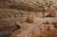
Once in Ashdown the gorge quickly rises to several hundred feet. Hiking in Ashdown I thought would be comparible to the narrows. It was in the fact that you are in a deep canyon with towering cliffs but other than that it was quite different. It was much easier. The river rock in Ashdown are much smaller and less slimy! Dont get me wrong walking on river rock sucks but compared to the snot covered bowling balls of the narrows it was nothing. Plus the river is fairly shallow and crossing it is simple. Another difference between the narrows and ashdown are the alcoves. Ashdown has these massive, deep alcoves that the creek has carved meandering through the gorge. In one place I read that in several thousand years several of these alcoves have potential to become natural bridges much like what is found in Natural Bridge National Monument especially since it is the same rock layer. I also was warned about flash flood danger and yes it is a canyon, and a flash flood could be massive but there are also tons and tons of options to get above everything but possibly a historically flash.


After a mile inside the gorge rattlesnake creek meets Ashdown Creek. I had previously read that there was a waterfall up rattlesnake (on the right) and another waterfall to the left. I took that to mean that both tributaries with the waterfalls confluenced with Ashdown but really the canyon with the second waterfall ran into Rattlesnake, not Ashdown. So we didnt end up seeing the second waterfall.

Back in Ashdown the gorge continued to impress from narrow high towering walls, to deep carved alcoves Ashdown Gorge is an impressive place. Eventually we met our first other hikers, a small group of scouts.


Eventually the canyon widened and lost much of its appeal. Somehow we also missed the natural bridge in the area.
As we met Cedar Creek we knew the end was near, what we didnt know was the chaos that was between us and our car. Whether from the landslide or the construction pushing dirt down into the canyon from the road below the creek is semi blocked creating ponds that basically have submerged the entire canyon. We tried to hug the sides of these ponds only to find quicksand nearly to the waist. Add to this the tangle of dead trees, large boulders, and up a head the sight of heavy machinery pushing ton boulders into the gorge and we were faced with decision. Do we continue to hike through this mess or hike up the landslide to the road. We decided hiking (I wouldnt call it hiking a steep scree scramble might be the best description) Eventually we arrived at the top and the construction workers were nice and told us to check in with the foreman before crossing the active construction. The foreman found us and wasnt too happy. He was more upset with Cedar Breaks/National Forest Service than us. He felt, and I think rightly so, the lower gorge should be closed. It is an active construction site and honestly is dangerous to have people crossing where they are pushing massive amounts of dirt and extremely large boulders into the canyon. If one of those rocks hit a hiker... It would be all over for that hiker.


You can still see pieces of the old highway which is kinda eery!

Even with an ugly end to the hike Ashdown Gorge, like Bill said, is one of the best hikes in Utah. Hopefully Cedar Breaks never becomes a NP because if so Ashdown will turn into a mini narrows. Not many people will hike in from the top, but from the bottom it is only a couple miles to get to the narrows of the gorge making it accessible to just about everyone
Featured image for home page: