napatony13
Member
- Joined
- Feb 5, 2021
- Messages
- 210
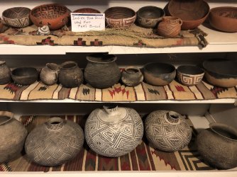
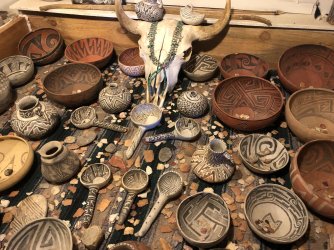
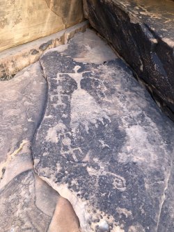
I recently saw an announcement about the imminent closing of Rock Art Ranch near Holbrook, AZ. Visiting there had been on my "bucket list" for years, so I made a reservation for their final day (12/07) and threw together a quick trip with plans to visit a few other sites in the vicinity. A few of these (RAR included) hardly qualify as hikes, but several were long enough to warrant a report. First just a couple shots of RAR...if you didn't get a chance to visit you really missed out. The petroglyphs were nice, but there little museum of relics they'd found on the property was incredible.
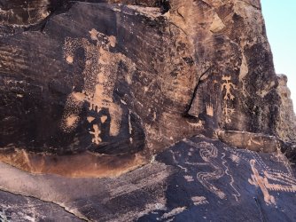
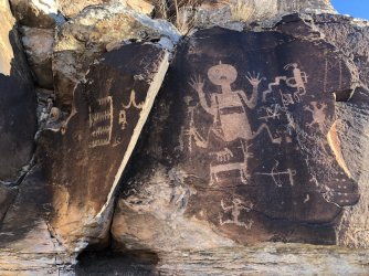
From there I headed east, and with a bit of daylight left I decided to try to locate a well-known panel along the Little Colorado River. I had a GPS waypoint for this site and was able to reach the cliffs after a short, easy hike. I began seeing glyphs almost immediately and the cliff band wasn't that extensive, so I figured I was home free. I was wrong. I reached the GPS point where it was supposed to be and no dice. So I started making loops and expanding my search area up and down the riverbank. There were more glyphs there than I realized, but I couldn't find the one I was looking for. Eventually I climbed up into a shallow cove and noticed a big slab that looked like a billboard. I intently made may way there, feeling this had to be it, only to be disappointed again. With daylight waning I decided to make one more pass and looped the big slab, first heading north, then backtracking to the south. As I crossed over my previous track all of a sudden there it was! I had been so intent on getting to the "big slab" I had overlooked my target off on my right side..."The Mother of Game":
Greatly relieved, I hiked back to the truck and followed a nice dirt road in the direction of Petrified Forest NP. I slept right outside the Park and was the first person in when the gates opened the next morning. After a brief stop at the Park museum I made my way to the starting point for my first hike. Parking on the shoulder of the road, I headed off towards another set of GPS waypoints. There were no trails, but an occasional shoeprint told me I wasn't the only person who had wandered out this way. After a couple miles a small but prominent butte came into view, and my track led directly to it. There was no drama this time, my target came into view from a fair ways out, an impressive spiral:

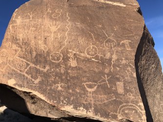
As I made my way around the butte, a few more small panels were found, but none quite as noteworthy as the spiral. I then continued onward, to a final GPS point I had highlighted on my map. This one was kind of a mystery...I had it colored blue which meant I felt it was better than average, but had no recollection of what exactly I was hoping to see. After trudging through the dry washes for another mile or so I could see I was heading for a rocky outcrop on the point of a low mesa. Once there, I immediately began finding panels, but upon reaching the far end there was nothing that matched my blue pin. So I carefully worked my way back the way I had come, taking a bit lower route. Then as I passed a large boulder I turned to see what was on the backside and there it was...very impressive:
Quite satisfied, I began tracing my route back to my truck. At one point I noticed quite a bit of colorful rock and petrified wood at my feet, so I decided to compose a picture of it. As I stooped down my gaze left the gaudier materials and picked up a small but unmistakable pottery sherd, then another and another.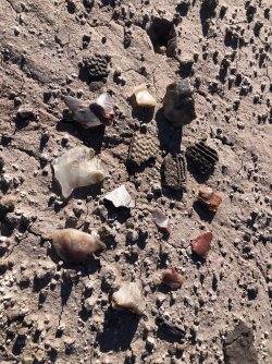
Finding this odd, I quickly scanned my surroundings looking for anything that looked like it might have been a habitation site. Nothing looked remotely possible, so I was a bit perplexed. But after walking another 75' or so I turned to look up the low sand dune on my right side and bingo: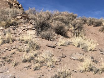
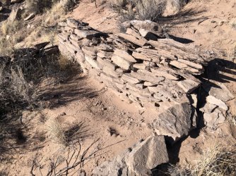
Just one room from what I could tell with no real reason I could see for being there, but I guess someone called it home:
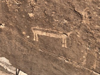
I made a quick pass through the closest boulders and found one interesting glyph, this "belted" deer?
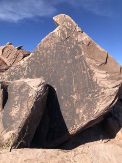
One back to my truck I headed towards the Park's north entrance and stopped when I reached the Painted Desert Inn. From here I would take my final hike and attempt to find the Flatiron Panel. After a steep initial descent I was once again out amongst the flat, dry desert washes, and again found myself tracking towards a prominent butte. In a repeat performance my GPS track was slightly misaligned, and I completely circled that butte, not finding the panel until almost all the way back to where I had started. But I found it and it was as good as I had hoped:
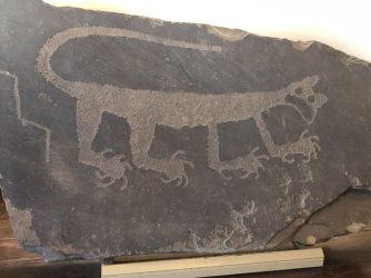
Mission accomplished, I headed back towards my truck. Once back up on top I stopped in at the Inn. In their lobby they have a famous mountain lion petroglyph that was removed from the Park back in the early days to protect it. It was a shame it couldn't be seen in its original location, but I'm happy that it's protected and in a place where others can see how remarkable the rock art in this area is.


From there I headed east, and with a bit of daylight left I decided to try to locate a well-known panel along the Little Colorado River. I had a GPS waypoint for this site and was able to reach the cliffs after a short, easy hike. I began seeing glyphs almost immediately and the cliff band wasn't that extensive, so I figured I was home free. I was wrong. I reached the GPS point where it was supposed to be and no dice. So I started making loops and expanding my search area up and down the riverbank. There were more glyphs there than I realized, but I couldn't find the one I was looking for. Eventually I climbed up into a shallow cove and noticed a big slab that looked like a billboard. I intently made may way there, feeling this had to be it, only to be disappointed again. With daylight waning I decided to make one more pass and looped the big slab, first heading north, then backtracking to the south. As I crossed over my previous track all of a sudden there it was! I had been so intent on getting to the "big slab" I had overlooked my target off on my right side..."The Mother of Game":

Greatly relieved, I hiked back to the truck and followed a nice dirt road in the direction of Petrified Forest NP. I slept right outside the Park and was the first person in when the gates opened the next morning. After a brief stop at the Park museum I made my way to the starting point for my first hike. Parking on the shoulder of the road, I headed off towards another set of GPS waypoints. There were no trails, but an occasional shoeprint told me I wasn't the only person who had wandered out this way. After a couple miles a small but prominent butte came into view, and my track led directly to it. There was no drama this time, my target came into view from a fair ways out, an impressive spiral:

As I made my way around the butte, a few more small panels were found, but none quite as noteworthy as the spiral. I then continued onward, to a final GPS point I had highlighted on my map. This one was kind of a mystery...I had it colored blue which meant I felt it was better than average, but had no recollection of what exactly I was hoping to see. After trudging through the dry washes for another mile or so I could see I was heading for a rocky outcrop on the point of a low mesa. Once there, I immediately began finding panels, but upon reaching the far end there was nothing that matched my blue pin. So I carefully worked my way back the way I had come, taking a bit lower route. Then as I passed a large boulder I turned to see what was on the backside and there it was...very impressive:

Quite satisfied, I began tracing my route back to my truck. At one point I noticed quite a bit of colorful rock and petrified wood at my feet, so I decided to compose a picture of it. As I stooped down my gaze left the gaudier materials and picked up a small but unmistakable pottery sherd, then another and another.

Finding this odd, I quickly scanned my surroundings looking for anything that looked like it might have been a habitation site. Nothing looked remotely possible, so I was a bit perplexed. But after walking another 75' or so I turned to look up the low sand dune on my right side and bingo:

Just one room from what I could tell with no real reason I could see for being there, but I guess someone called it home:

I made a quick pass through the closest boulders and found one interesting glyph, this "belted" deer?

One back to my truck I headed towards the Park's north entrance and stopped when I reached the Painted Desert Inn. From here I would take my final hike and attempt to find the Flatiron Panel. After a steep initial descent I was once again out amongst the flat, dry desert washes, and again found myself tracking towards a prominent butte. In a repeat performance my GPS track was slightly misaligned, and I completely circled that butte, not finding the panel until almost all the way back to where I had started. But I found it and it was as good as I had hoped:

Mission accomplished, I headed back towards my truck. Once back up on top I stopped in at the Inn. In their lobby they have a famous mountain lion petroglyph that was removed from the Park back in the early days to protect it. It was a shame it couldn't be seen in its original location, but I'm happy that it's protected and in a place where others can see how remarkable the rock art in this area is.

