- Joined
- Dec 23, 2013
- Messages
- 4,124
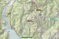
I headed out on my last backpacking trip over the Columbus Day weekend; our destination was Arizona Creek in the Teton Wilderness. We (Brian, Cory and I) would drive up from Salt Lake City, hike in about five miles to Bailey Meadows to make camp, continue on the next day to Brown Meadows to camp and visit Tom Brown’s grave site, then on day four, do a day hike to the Historic Huckleberry Fire Lookout, before retracing our route back to the trailhead on day four. The mileage for the trip (including the day hike) was roughly 25 miles roundtrip. Here is our story.

Trip overview map
Day 1 - Arizona Creek Trailhead to Bailey Meadows – We got an early start and left Salt Lake at 5:30 am on October 10th. After stopping for a quick breakfast, we continued on to the Arizona Creek Trailhead. We arrived at one o’clock in the afternoon where we proceeded to get our gear ready and to wait for the fourth person (@Joey) in our group who was going to meet us at the trailhead after backpacking in Yellowstone for the past week.
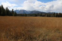
After 45 minutes we decided to begin our hike into Bailey Meadows without @Joey, who would catch up to us later. The first part of the trail takes you through a couple of meadows, then some willows down by Arizona Creek.

Meadow near trailhead

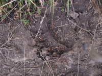
Grizzly track on the trail

Hiking along the willows

Arizona Creek
After passing along the willows, you have a simple crossing of Arizona Creek and then a short distance later hit the wilderness boundary. At this point, we pass along more willows until the uphill section of our route begins. Once we start uphill, we have about a 750 ft. climb to Bailey Meadows and some sections are rather steep. At the end of the climb, there is a slight downhill until you break out into the meadows. Up until now, Cory began the hike as “point man” and after a break Brian took over that roll. But when we arrived at Bailey Meadows, we stopped to take some pictures of the meadow after which I headed out ahead of the others who still had more pictures to take. About 200 yards into the meadow I pass a spruce tree on my left and lo and behold there is a grizzly bear on the other side about fifteen yards and slightly up the hill from me on my left. I quickly scan the area for cubs while the bear, which is not facing me, turns his head and sees me. For a millisecond, we both freeze and look at each other before the bear bolts up the hill. It is amazing how quickly a grizzly can go from a complete standstill to a full run. It is fast! I yelled back to Brian who was still a good piece behind me, “Grizzly Bear.” Brian was able to catch a glimpse of him as her ran through some of the spruce trees near the edge of the meadow, but Cory was too far back to see him before he crested the hill. Man what an adrenaline rush! After my extremely close encounter last year along the North Fork of the Yellowstone, I think I may have used up two of my nine lives already. I guess that I am lucky that I have not been charged. Anyway, it is a magnificent creature to behold in its natural setting.

Bailey Meadows

Grizzly bear is behind the nearest spruce tree on the left (I haven't seen him yet)
After that excitement, we walked out in the meadow to see if we could find a water source, which we could not. Bailey Creek was dry where it ran through the meadow. This created a dilemma for us because this is the location that we were going to meet Joey and camp. If we continued on, Joey would not know where to find us. We moved on to the north end of the meadow and found water in the creek. I guess when it flows into the meadow proper; it must soak into the ground.
We set up camp and began to eat dinner when along about 6:30, we could see Joey emerging from the trees on the opposite side of the meadow. After setting up his tent, Joey joined us for dinner and conversation by the fire.
I went to bed about 8:45 and when I climbed into my tent a group of deer ran by, not two feet from my tent. I also heard horses, which turned out to be hunters who were camped at the southern end of the meadows. They told my companions that they had lost a camouflaged jacket and that if they found it tomorrow to put it by the trail so that they would see it and pick it up. They told them that they would. I drifted off to sleep.
Day 2 – Bailey Meadows to Brown Meadows – Woke up this morning to 22 degrees and a Bull Moose just south of our campsite grazing in the willows that stretched out in the middle of the meadow. We took our time getting breakfast, waiting for the sun to engulf us and warm us up a bit.
After eating, we packed up and headed out. Today’s hike is only five miles, but the first part of it after leaving Bailey Meadows is gradually going uphill. We break out of the trees, to enjoy open space at the base of Wildcat Ridge.

First glimpse of Wildcat Ridge

Scatman and @Joey with the Tetons in the background
After hiking through the clearing, we begin to drop down to Arizona Creek. Before we reach the creek, we find the camouflage Jacket the hunters had lost. We propped it up on a make shift pole next to the trail and then decided to take a break.

South end of Huckleberry Ridge with the Arizona Creek drainage in the foreground
While on break, the hunters came by and we showed them the jacket. They had come from the direction of Brown Meadows and said that they had spooked a sow and two cubs plus a large male grizzly in the direction we were heading and asked us if we had a gun. We responded, “No, we carry bear spray instead.” They wished us luck and thanked us for finding their coat and continued on their way back to Bailey Meadows. Well, who wants to be point man now? I take the lead and we head down to cross Arizona Creek. After crossing the creek, we start climbing a little over 600 feet to reach Brown Meadows. Before we reach the meadows, we lose the trail and have to find our way back to it. It turns out we took the old trail before it was rerouted after the 1988 fires. We eventually hook up to the new trail and end up at Brown Meadows.

Heading through willows approaching Brown Meadows

Brown Meadows
After setting up camp, we made our way over to Brown’s Grave. Brown’s Grave is the grave site of a gentleman named Thomas Brown who froze to death while bear hunting back in 1891. His hunting partner buried him in the meadow. The grave site today is run down and needs some upkeep, but it was still interesting to see. After leaving the grave, we hiked down to overlook the Rodent Creek drainage which looks like some wild country that needs exploring in the future. We eventually made our way back to camp for dinner and after eating hit the sack.

Brown's grave site

Willows along the Rodent Creek Trail

Looking out over the Rodent Creek drainage
Day 3 – Day hike to Huckleberry Lookout – This morning it is 26 degrees and there is an inch of snow on the ground.

Snow in the morning
 Brown Meadows in the snow
I shake off my tent to get the snow removed before eating breakfast. After eating, we took off for Huckleberry Lookout. Once leaving Brown Meadows, the trail gradually ascends upward. The snow changed from light to heavy then stopped along the trail. Once we arrive at the base of the ridge, the trail gets quite steep as it works its way to the top of Huckleberry Ridge. On top, there is a strong wind is blowing. About one hundred feet from the lookout, two grouse explode out of the trees to get my heart racing. Bear of grouse; I’m not sure which is more nerve racking.

Wildcat Ridge and Wildcat Peak, seen on our hike to Huckleberry Lookout

Sheffield Creek Trail

On the ridge

Huckleberry Lookout
We reach the lookout and climb the stairs and go inside. Inside the lookout there is a table, four camping chairs, and two sleeping bags with pads, an axe and other knick knacks. At one time there was a stove but it has been removed. There is an interesting instrument at the center of the lookout that at one time was used to pinpoint the exact location of a fire. We eat our lunch in the lookout while the snow picks up outside. We wait out the storm and are able to get some nice pictures when most of the clouds clear off. The view is tremendous! You can see Mount Sheridan, Heart Lake, Yellowstone Lake, and the Pitchstone Plateau to the north. To the south you can see deep into the Teton Wilderness along with Jackson Lake and the Tetons. Once we were finished taking pictures, we started on our way back to camp. Along the way back, it begins to snow again.

View of Brown Meadows and Wildcat Peak from the lookout
Before eating dinner, Brian and I walk over to the west side of the meadow where there are some small cliffs that sit above Arizona Creek. We take a few pictures and then head back to eat. After dinner we sit around the campfire drying some of our clothing before calling it a night.

View down the Arizona Creek drainage from the cliffs on the west end of Brown Meadows
Day 4 – Out to the Arizona Creek Trailhead – It’s a chilly morning at 8 degrees! The clouds have cleared off and have taken any remaining heat with them. I have a tough time getting out of my sleeping bag, but eventually find the courage.

8 degree morning at Brown Meadows

Huckleberry Ridge

Huckleberry Ridge
It takes us a good long while to eat, pack up and get moving. The trail is frozen at first but as the day proceeds it becomes just muddy.

Wildcat Ridge, taken on our way out
On one steep downhill stretch, I slip on mud and fall, hitting the side of my thigh on a log by the trail. Ouch! That’s going to leave a nasty bruise. We cross Arizona Creek and hike up and out of the drainage again and eventually stop and eat lunch at Bailey Meadows. After lunch, I show Joey the place where the grizzly encounter took place on the way in. The rest of the hike out is pleasant with a couple more grouse keeping it interesting. We arrive back at the trailhead, where two hunters are headed in to break down a hunting camp. One of them is kind enough to take a group shot of us and then we are on our way to get food and a beer.
Thoughts – I love hiking in the fall; the temperatures suite me, the colors are wonderful (though past their prime) and the snow on this trip just added to it. We were able to see some of wildlife along the way. I need to get back into the Rodent Creek and Coulter Creek area in the future. This was a great trip and an area worth exploring if you haven’t seen it before.
For those who want to see all the images taken on the trip, here is thew link:
Arizona Creek / Huckleberry lookout Trip Images
Enjoy!
Featured image for home page:

Trip overview map
Day 1 - Arizona Creek Trailhead to Bailey Meadows – We got an early start and left Salt Lake at 5:30 am on October 10th. After stopping for a quick breakfast, we continued on to the Arizona Creek Trailhead. We arrived at one o’clock in the afternoon where we proceeded to get our gear ready and to wait for the fourth person (@Joey) in our group who was going to meet us at the trailhead after backpacking in Yellowstone for the past week.
After 45 minutes we decided to begin our hike into Bailey Meadows without @Joey, who would catch up to us later. The first part of the trail takes you through a couple of meadows, then some willows down by Arizona Creek.
Meadow near trailhead
Grizzly track on the trail
Hiking along the willows
Arizona Creek
After passing along the willows, you have a simple crossing of Arizona Creek and then a short distance later hit the wilderness boundary. At this point, we pass along more willows until the uphill section of our route begins. Once we start uphill, we have about a 750 ft. climb to Bailey Meadows and some sections are rather steep. At the end of the climb, there is a slight downhill until you break out into the meadows. Up until now, Cory began the hike as “point man” and after a break Brian took over that roll. But when we arrived at Bailey Meadows, we stopped to take some pictures of the meadow after which I headed out ahead of the others who still had more pictures to take. About 200 yards into the meadow I pass a spruce tree on my left and lo and behold there is a grizzly bear on the other side about fifteen yards and slightly up the hill from me on my left. I quickly scan the area for cubs while the bear, which is not facing me, turns his head and sees me. For a millisecond, we both freeze and look at each other before the bear bolts up the hill. It is amazing how quickly a grizzly can go from a complete standstill to a full run. It is fast! I yelled back to Brian who was still a good piece behind me, “Grizzly Bear.” Brian was able to catch a glimpse of him as her ran through some of the spruce trees near the edge of the meadow, but Cory was too far back to see him before he crested the hill. Man what an adrenaline rush! After my extremely close encounter last year along the North Fork of the Yellowstone, I think I may have used up two of my nine lives already. I guess that I am lucky that I have not been charged. Anyway, it is a magnificent creature to behold in its natural setting.
Bailey Meadows
Grizzly bear is behind the nearest spruce tree on the left (I haven't seen him yet)
After that excitement, we walked out in the meadow to see if we could find a water source, which we could not. Bailey Creek was dry where it ran through the meadow. This created a dilemma for us because this is the location that we were going to meet Joey and camp. If we continued on, Joey would not know where to find us. We moved on to the north end of the meadow and found water in the creek. I guess when it flows into the meadow proper; it must soak into the ground.
We set up camp and began to eat dinner when along about 6:30, we could see Joey emerging from the trees on the opposite side of the meadow. After setting up his tent, Joey joined us for dinner and conversation by the fire.
I went to bed about 8:45 and when I climbed into my tent a group of deer ran by, not two feet from my tent. I also heard horses, which turned out to be hunters who were camped at the southern end of the meadows. They told my companions that they had lost a camouflaged jacket and that if they found it tomorrow to put it by the trail so that they would see it and pick it up. They told them that they would. I drifted off to sleep.
Day 2 – Bailey Meadows to Brown Meadows – Woke up this morning to 22 degrees and a Bull Moose just south of our campsite grazing in the willows that stretched out in the middle of the meadow. We took our time getting breakfast, waiting for the sun to engulf us and warm us up a bit.
After eating, we packed up and headed out. Today’s hike is only five miles, but the first part of it after leaving Bailey Meadows is gradually going uphill. We break out of the trees, to enjoy open space at the base of Wildcat Ridge.
First glimpse of Wildcat Ridge
Scatman and @Joey with the Tetons in the background
After hiking through the clearing, we begin to drop down to Arizona Creek. Before we reach the creek, we find the camouflage Jacket the hunters had lost. We propped it up on a make shift pole next to the trail and then decided to take a break.
South end of Huckleberry Ridge with the Arizona Creek drainage in the foreground
While on break, the hunters came by and we showed them the jacket. They had come from the direction of Brown Meadows and said that they had spooked a sow and two cubs plus a large male grizzly in the direction we were heading and asked us if we had a gun. We responded, “No, we carry bear spray instead.” They wished us luck and thanked us for finding their coat and continued on their way back to Bailey Meadows. Well, who wants to be point man now? I take the lead and we head down to cross Arizona Creek. After crossing the creek, we start climbing a little over 600 feet to reach Brown Meadows. Before we reach the meadows, we lose the trail and have to find our way back to it. It turns out we took the old trail before it was rerouted after the 1988 fires. We eventually hook up to the new trail and end up at Brown Meadows.
Heading through willows approaching Brown Meadows
Brown Meadows
After setting up camp, we made our way over to Brown’s Grave. Brown’s Grave is the grave site of a gentleman named Thomas Brown who froze to death while bear hunting back in 1891. His hunting partner buried him in the meadow. The grave site today is run down and needs some upkeep, but it was still interesting to see. After leaving the grave, we hiked down to overlook the Rodent Creek drainage which looks like some wild country that needs exploring in the future. We eventually made our way back to camp for dinner and after eating hit the sack.
Brown's grave site
Willows along the Rodent Creek Trail
Looking out over the Rodent Creek drainage
Day 3 – Day hike to Huckleberry Lookout – This morning it is 26 degrees and there is an inch of snow on the ground.
Snow in the morning
Brown Meadows in the snowI shake off my tent to get the snow removed before eating breakfast. After eating, we took off for Huckleberry Lookout. Once leaving Brown Meadows, the trail gradually ascends upward. The snow changed from light to heavy then stopped along the trail. Once we arrive at the base of the ridge, the trail gets quite steep as it works its way to the top of Huckleberry Ridge. On top, there is a strong wind is blowing. About one hundred feet from the lookout, two grouse explode out of the trees to get my heart racing. Bear of grouse; I’m not sure which is more nerve racking.
Wildcat Ridge and Wildcat Peak, seen on our hike to Huckleberry Lookout
Sheffield Creek Trail
On the ridge
Huckleberry Lookout
We reach the lookout and climb the stairs and go inside. Inside the lookout there is a table, four camping chairs, and two sleeping bags with pads, an axe and other knick knacks. At one time there was a stove but it has been removed. There is an interesting instrument at the center of the lookout that at one time was used to pinpoint the exact location of a fire. We eat our lunch in the lookout while the snow picks up outside. We wait out the storm and are able to get some nice pictures when most of the clouds clear off. The view is tremendous! You can see Mount Sheridan, Heart Lake, Yellowstone Lake, and the Pitchstone Plateau to the north. To the south you can see deep into the Teton Wilderness along with Jackson Lake and the Tetons. Once we were finished taking pictures, we started on our way back to camp. Along the way back, it begins to snow again.
View of Brown Meadows and Wildcat Peak from the lookout
Before eating dinner, Brian and I walk over to the west side of the meadow where there are some small cliffs that sit above Arizona Creek. We take a few pictures and then head back to eat. After dinner we sit around the campfire drying some of our clothing before calling it a night.
View down the Arizona Creek drainage from the cliffs on the west end of Brown Meadows
Day 4 – Out to the Arizona Creek Trailhead – It’s a chilly morning at 8 degrees! The clouds have cleared off and have taken any remaining heat with them. I have a tough time getting out of my sleeping bag, but eventually find the courage.
8 degree morning at Brown Meadows
Huckleberry Ridge
Huckleberry Ridge
It takes us a good long while to eat, pack up and get moving. The trail is frozen at first but as the day proceeds it becomes just muddy.
Wildcat Ridge, taken on our way out
On one steep downhill stretch, I slip on mud and fall, hitting the side of my thigh on a log by the trail. Ouch! That’s going to leave a nasty bruise. We cross Arizona Creek and hike up and out of the drainage again and eventually stop and eat lunch at Bailey Meadows. After lunch, I show Joey the place where the grizzly encounter took place on the way in. The rest of the hike out is pleasant with a couple more grouse keeping it interesting. We arrive back at the trailhead, where two hunters are headed in to break down a hunting camp. One of them is kind enough to take a group shot of us and then we are on our way to get food and a beer.
Thoughts – I love hiking in the fall; the temperatures suite me, the colors are wonderful (though past their prime) and the snow on this trip just added to it. We were able to see some of wildlife along the way. I need to get back into the Rodent Creek and Coulter Creek area in the future. This was a great trip and an area worth exploring if you haven’t seen it before.
For those who want to see all the images taken on the trip, here is thew link:
Arizona Creek / Huckleberry lookout Trip Images
Enjoy!
Featured image for home page:
Attachments
Last edited:
