John Kerby
Member
- Joined
- Feb 18, 2013
- Messages
- 85
I will be leaving Wichita ks July 9th at 11pm, driving all night and day to get there by dinner July 10th. Think we will be at the trail head by 6pm at the Boulder Airport. Will end up at the Highway 12 bridge at my truck.
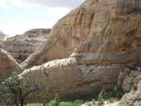
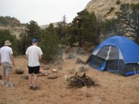
1. Do you more experienced hikers think we could set out as late as 6pm to get a little ways into the hike? Think we could make a water source before sundown and camp for the night? I remember from my 09 trip (didn't finish hike, went maybe 8 miles in) that the early hike away from the airport is basically solid rock.....Probably not comfortable to throw a tent and sleep on....
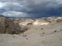
2. The Boulder Airport to Death Holow, to the Highway 12 bridge will take us down Death Hollow to the confluence of the Escalante and DH right?
3. Am I correct in that this hike is a 16-17 mile?
In 2009 I hiked it with 3 guy friends, went to the start of Death Hollow, down into the canyon, explored around, and hiked out. Did some rock climbing and exploring on the trail into that point. So I did not experience the best part of it. On this trip, I am the leader as I am the only one who has been there.....Just want to have as much info as possible. Have a 13 (almost 14) year old girl coming with us. All of us are pumped and excited.....
Thanks guys.
1. Do you more experienced hikers think we could set out as late as 6pm to get a little ways into the hike? Think we could make a water source before sundown and camp for the night? I remember from my 09 trip (didn't finish hike, went maybe 8 miles in) that the early hike away from the airport is basically solid rock.....Probably not comfortable to throw a tent and sleep on....
2. The Boulder Airport to Death Holow, to the Highway 12 bridge will take us down Death Hollow to the confluence of the Escalante and DH right?
3. Am I correct in that this hike is a 16-17 mile?
In 2009 I hiked it with 3 guy friends, went to the start of Death Hollow, down into the canyon, explored around, and hiked out. Did some rock climbing and exploring on the trail into that point. So I did not experience the best part of it. On this trip, I am the leader as I am the only one who has been there.....Just want to have as much info as possible. Have a 13 (almost 14) year old girl coming with us. All of us are pumped and excited.....
Thanks guys.