IntrepidXJ
ADVENTR
- Joined
- Jan 17, 2012
- Messages
- 3,493
Sunday, October 28, 2012
The Original Trip Report on ADVENTR.CO
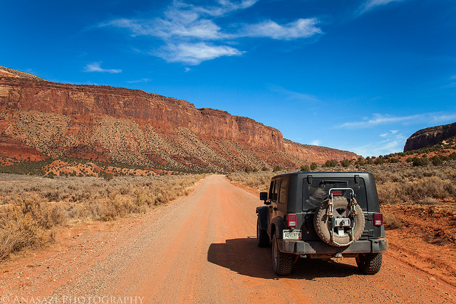
It was one of those days that I just needed to get out hiking and exploring by myself, so that's what I set out to do. Last year around Christmas I had planned to hike along the Dolores River near Bedrock but got a severe headache on the drive there and had to turn around and head back home. I hadn't made it back that way yet, so I thought it would be a good time to try again. After leaving home and driving through Unaweep Canyon to Gateway, I then followed the Dolores River to Paradox Valley and turned off at the dead-end road by the Bedrock store to the boat ramp. One day soon I want to float the Dolores River from the Big Gypsum Valley to Bedrock and wanted to check out the takeout. After leaving the boat ramp the road I was on got a bit rougher, but I managed to drive a little ways further until I reached and area that was completely washed out. I parked my Jeep there and continued along the river on foot. The hike was easy and for the most part since it followed an old road that hadn't been drivable in quite some time. After a few miles I reached a few boulders with petroglyphs on them that I had hoped to find.
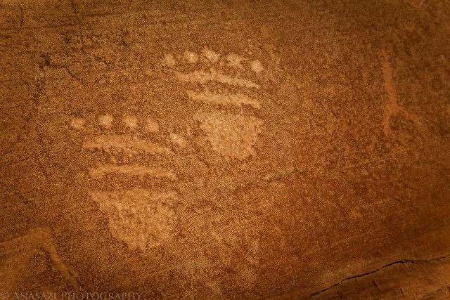
On the back of the main boulder there were a few faint bear paw petroglyphs next to some nice lichen.
Bear Paws by IntrepidXJ, on Flickr
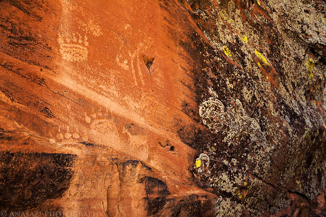
The front of the main boulder had a bunch of faded petroglyphs that have been vandalized over the years.
Petroglyphs & Graffiti by IntrepidXJ, on Flickr
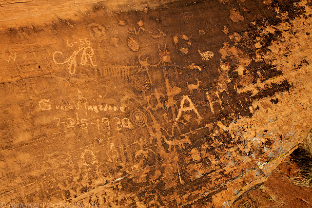
Triangle body with big hands.
Long Arms by IntrepidXJ, on Flickr
Two more paw prints.
Prints by IntrepidXJ, on Flickr
After checking out the petroglyphs and thoroughly searching other boulders in the area for more, I continued my hike along the Dolores to it's confluence with La Sal Creek.
Look closely and you can see a reflection of the canyon towering above.
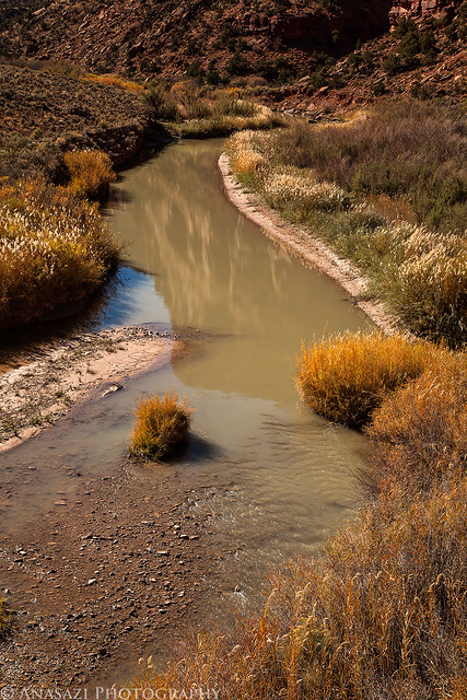
Dolores Reflection by IntrepidXJ, on Flickr
When I reached La Sal Creek I searched the area for rock art and tried to continue my hike up along the creek. At first there was a faint trail through the thick brush, but it soon disappeared. I was faced with the decision to either bushwhack my way up the canyon or turn around and head back. I wasn't really feeling like bushwhacking at this time, so I turned back.
On my way back I decided to check a few more boulder for petroglyphs, and I'm glad I did. I ended up finding this large boulder with a layer that looked like petrified mud which had small tracks all over it. If you look closely at the photo below you will see at least nine of these tracks. From what little online research I have done, it appears that these are possibly small dinosaur tracks.
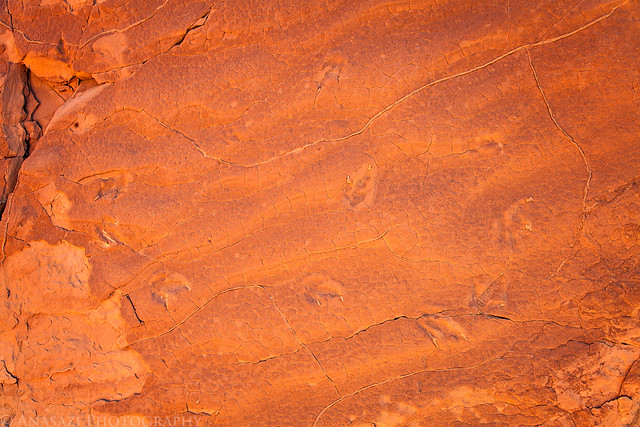
Circle of Tracks by IntrepidXJ, on Flickr
I've seen plenty of dinosaur tracks in sandstone before, but what was really unique about this site to me is that some of the tracks were still filled with the layer of sandstone that was deposited over them and helped preserve them. This is something I have not seen before, and it helps me really visualize the process in which these tracks were preserved and then revealed again. The photo below shows this well, and I have included my hand for some scale.
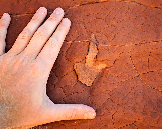
Track Size by IntrepidXJ, on Flickr
Hiking back along the old road towards my Jeep and Paradox Valley in the distance.
Old Road Hiking by IntrepidXJ, on Flickr
Leaving Paradox Valley.
Leaving Paradox by IntrepidXJ, on Flickr
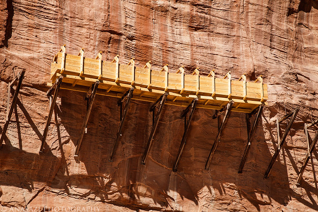
On my way back to the highway I stopped to take a photo of the rebuilt section of the Hanging Flume above the San Miguel River. I have been to this site before, but not since they rebuilt this small section in the spring.
Rebuilt Flume by IntrepidXJ, on Flickr
As I was driving through Gateway on my way back home, I decided to take another side trip along the Dolores River into Utah since I still had plenty of daylight left.
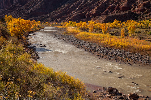
There was still some nice fall color along the Dolores river near the Colorado - Utah state line.
Dolores Color by IntrepidXJ, on Flickr
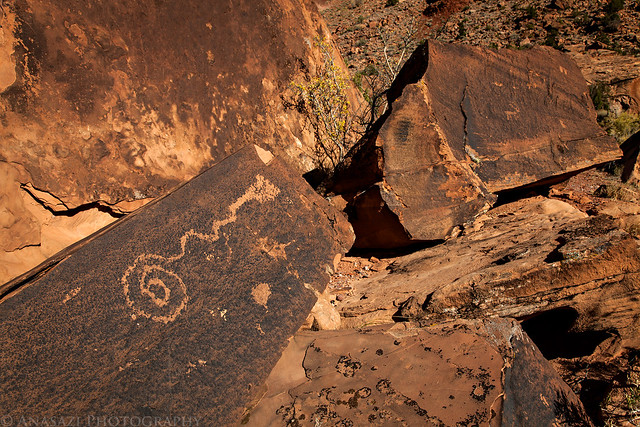
I even managed to find a few more petroglyphs that I had not seen the last time I drove down this road.
Boulder Glyphs by IntrepidXJ, on Flickr
A sunburst through cottonwood trees displaying their fall colors.
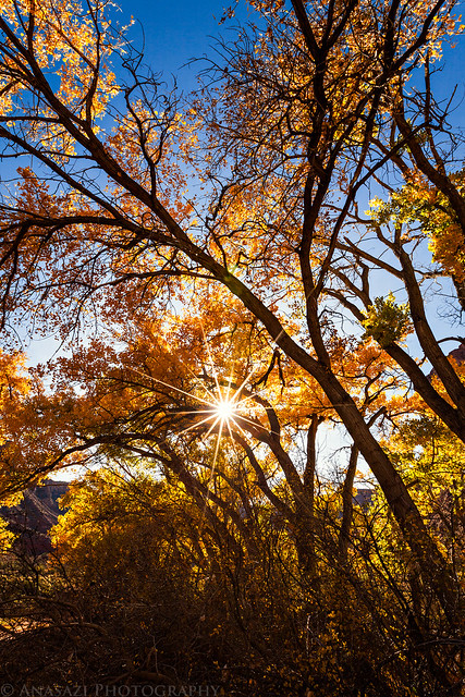
Cottonwoods by IntrepidXJ, on Flickr
After a burger from the Paradox Grille at Gateway Canyons Resort I continued my drive back home through Unaweep Canyon.
I made one last roadside stop at the Driggs Mansion and Thimble Rock for a quick photo.
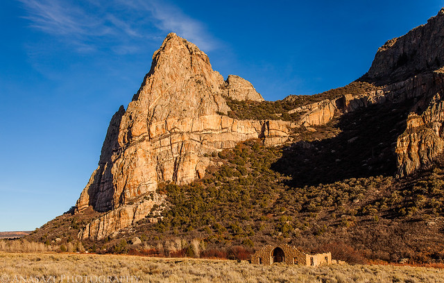
Driggs Mansion by IntrepidXJ, on Flickr
>> Along the Dolores Photo Gallery
Featured image for home page:

The Original Trip Report on ADVENTR.CO
It was one of those days that I just needed to get out hiking and exploring by myself, so that's what I set out to do. Last year around Christmas I had planned to hike along the Dolores River near Bedrock but got a severe headache on the drive there and had to turn around and head back home. I hadn't made it back that way yet, so I thought it would be a good time to try again. After leaving home and driving through Unaweep Canyon to Gateway, I then followed the Dolores River to Paradox Valley and turned off at the dead-end road by the Bedrock store to the boat ramp. One day soon I want to float the Dolores River from the Big Gypsum Valley to Bedrock and wanted to check out the takeout. After leaving the boat ramp the road I was on got a bit rougher, but I managed to drive a little ways further until I reached and area that was completely washed out. I parked my Jeep there and continued along the river on foot. The hike was easy and for the most part since it followed an old road that hadn't been drivable in quite some time. After a few miles I reached a few boulders with petroglyphs on them that I had hoped to find.
On the back of the main boulder there were a few faint bear paw petroglyphs next to some nice lichen.
Bear Paws by IntrepidXJ, on Flickr
The front of the main boulder had a bunch of faded petroglyphs that have been vandalized over the years.
Petroglyphs & Graffiti by IntrepidXJ, on Flickr
Triangle body with big hands.
Long Arms by IntrepidXJ, on Flickr
Two more paw prints.
Prints by IntrepidXJ, on Flickr
After checking out the petroglyphs and thoroughly searching other boulders in the area for more, I continued my hike along the Dolores to it's confluence with La Sal Creek.
Look closely and you can see a reflection of the canyon towering above.
Dolores Reflection by IntrepidXJ, on Flickr
When I reached La Sal Creek I searched the area for rock art and tried to continue my hike up along the creek. At first there was a faint trail through the thick brush, but it soon disappeared. I was faced with the decision to either bushwhack my way up the canyon or turn around and head back. I wasn't really feeling like bushwhacking at this time, so I turned back.
On my way back I decided to check a few more boulder for petroglyphs, and I'm glad I did. I ended up finding this large boulder with a layer that looked like petrified mud which had small tracks all over it. If you look closely at the photo below you will see at least nine of these tracks. From what little online research I have done, it appears that these are possibly small dinosaur tracks.
Circle of Tracks by IntrepidXJ, on Flickr
I've seen plenty of dinosaur tracks in sandstone before, but what was really unique about this site to me is that some of the tracks were still filled with the layer of sandstone that was deposited over them and helped preserve them. This is something I have not seen before, and it helps me really visualize the process in which these tracks were preserved and then revealed again. The photo below shows this well, and I have included my hand for some scale.
Track Size by IntrepidXJ, on Flickr
Hiking back along the old road towards my Jeep and Paradox Valley in the distance.
Old Road Hiking by IntrepidXJ, on Flickr
Leaving Paradox Valley.
Leaving Paradox by IntrepidXJ, on Flickr
On my way back to the highway I stopped to take a photo of the rebuilt section of the Hanging Flume above the San Miguel River. I have been to this site before, but not since they rebuilt this small section in the spring.
Rebuilt Flume by IntrepidXJ, on Flickr
As I was driving through Gateway on my way back home, I decided to take another side trip along the Dolores River into Utah since I still had plenty of daylight left.
There was still some nice fall color along the Dolores river near the Colorado - Utah state line.
Dolores Color by IntrepidXJ, on Flickr
I even managed to find a few more petroglyphs that I had not seen the last time I drove down this road.
Boulder Glyphs by IntrepidXJ, on Flickr
A sunburst through cottonwood trees displaying their fall colors.
Cottonwoods by IntrepidXJ, on Flickr
After a burger from the Paradox Grille at Gateway Canyons Resort I continued my drive back home through Unaweep Canyon.
I made one last roadside stop at the Driggs Mansion and Thimble Rock for a quick photo.
Driggs Mansion by IntrepidXJ, on Flickr
>> Along the Dolores Photo Gallery
Featured image for home page: