- Joined
- Feb 21, 2024
- Messages
- 95
I snuck up into the heart of the Sangre de Cristo Range in southern Colorado this weekend. My only true parameters were that I couldn't light out of Denver until around 1 PM on Friday and had to be back to town for a birthday party for my daughter's classmate by 4 PM MT on Sunday. Those, and ideally finding a spot I'd not yet seen that wouldn't have a ton of other folks there, too.
I'd done some limited day hiking in the Sangres before, including a failed attempt at summiting Mt. Lindsey back in 2021. The steep nature of their trails and rugged mountains always piqued my interest, but for whatever reason I'd headed past them, or around them altogether when given the chance to do some backpacking in the state.
I settled on Cotton Lake as my destination this time around. If the traffic gods allowed, I could get down to the Cotton Creek TH early enough to get a ~5 PM start, and given its location on the western slope of the range I knew I'd have as much sunlight as possible to hike in. It was somewhere in the range of 8 miles up to the foot of the lake (and about 3,000 feet of steady up) and there was additional 'trail' along the Rito Alto Trail should I get any more gumption, and I settled on what should've been an easy peasy 3-day, 2-night trip.
I swung through Buena Vista on the way and hit Eddyline for a pint of courage seeing as I'd be solo this trip - I also needed a fuel canister, and hat-tip to The Trailhead for hooking me up. I've done five or seven solo overnights before and don't fear them, but I'd fallen into such a pattern of only doing trips with other folks that I'd somewhat forgotten the ins and outs until the drive down.
Anyway, with no rain in the Friday forecast and the trail as my oyster, I pulled into the TH a bit before 5 PM on Friday to find nary another car parked. It was odd to the point where I honestly wasn't sure where to leave my car, but that sorted itself quickly and off I went.
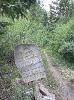
The first 1.5 or so mile traverses Rio Grande NF land before reaching the Sangre de Cristo Wilderness, and though the lower trail doesn't get much human foot traffic it's an understatement to say that it gets a boatload of cattle traffic. Cow poo was rampant, though fortunately the trail was wide enough in most places to hopscotch my way through it.
My plan was to hike in until I found a suitable site, ideally in the ~3ish mile area. That would give me plenty of time to get camp and dinner ready before dark and only have a ~5 mile push up to Cotton Lake on Saturday. I was searching for anything flat with skies open above me, though the densely packed aspen forest around the 9,000 to 9,500 foot range coincided with a steady and decidedly not-flat slope. On top of that, beetle kill had zapped so many of the pines that finding a clearing of any sort was too much to ask within eyesight of the trail, and I became resigned to the fact that hiking in further than I'd initially planned would be paramount.
Thank heck for long days, in this instance.
The first truly flat spot I found ended up featuring a wonderful site along the banks of Cotton Creek. It was readily evident that trail crew had stayed there given how many of the logs there had been sawed. While it was clear there'd been good maintenance lower on the trail before reaching that camp, I'd find out on Saturday just how much work that crew had been doing of late.
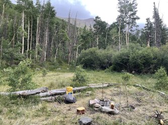
The Rito Alto up to Cotton Lake was not at all 'well used.' It was foot-in-front-of-the-other in a lot of places, with walkarounds of downed logs a built-in feature. That said, it was incredibly 'well maintained' because had the trail crew not meticulously carved through many of the places where you'd otherwise squint and grumble, you wouldn't have known there was a trail there at all. I saw nobody on this trip, and while campsites were abundant in Henderson Gulch around the 10,000 foot level, it didn't appear many had been used too often.
I wonder now if I'd simply lucked out into a) the trail crew's home base right after they'd cleared it all and b) got there before the upper trail had been cleared well enough for folks to really get up in there in 2025.
The sounds of the creek were the perfect backdrop under the eyes of De Anza Peak (13,366 ft), Electric Peak (13,573 ft), and Mount Marcy (13,494 ft). A Crank Yanker and a sit by the fire put me to sleep with the knowledge I'd push on to Cotton Lake in the morning giving me dream fuel. As I look back on the map, I knocked out about 4.7 miles and 1,800 feet of the climb on Friday, setting up just past the trail junction that takes you up Horsethief Basin and over the divide to Banjo Lake and Middle Brush Creek.
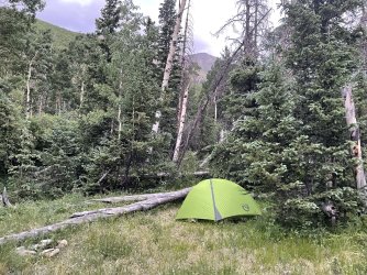
I tucked my tent into the trees on purpose knowing that they, and the 13ers (De Anza above) behind me, lay east of me. I'd be in the shade into mid-morning, the hope being I'd sleep late and avoid the mid-80s temperatures as long as possible on what otherwise was set to be a steamy Saturday.
That part of the plan worked perfectly. I slept hard until almost 9 AM, something you just don't get with a 4 year old and 2 year old running your house every other day. I was super dehydrated, something I'd feared when going to bed after such a hot walk in, and I made it a point to load up on water intake before ever setting foot on the trail that day. So, I didn't even get packed up and moving until around 11 AM, doing so under perfectly clear skies that allowed the sun to beam all over me.
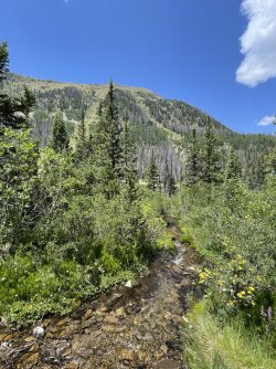
It got hot in a hurry. Though I was still mostly in the trees after camping around ~10,300 ft, many of them were dead pines as I'd moved above the aspen grove. On top of that, turning around the bend to the southeast dropped me into Henderson Gulch, a spacious meadow surrounding Cotton Creek that was more sparse on trees than the densely packed lower trail. Fortunately, the trail hugged the creek through much of it early, even keeping it with frequent access points past the Middle Fork junction, and I chugged up on the final side stream in the Gulch before the trail climbed up the east wall on the ascent up to Cotton Lake.
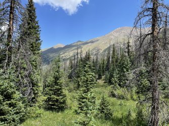
Looking southwest with De Anza Peak (right) and Electric Peak (left) in the distance from Henderson Gulch.
The Cotton Creek drainage just below the lake and Lion Gulch at the foot were simply gorgeous even through the beetle kill. A small herd of elk was grazing a few hundred yards away in the meadows as I inched closer to the lake, and their signs (and bear scat) had been plentiful on the trek up to that point. For as dry as much of the southern portion of Colorado has been for most of 2025 (and years before), this basin was simply lush, and it's clear that wildlife both knew and appreciated that aspect of it. I'd seen a garter snake on the trail just a few hundred yards in on Friday, scared an elk in the creek basin shortly after, and the first thing I saw when I sat down at Cotton Lake was a bald eagle soaring above it.
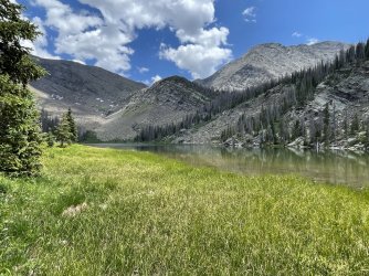
All that and nary a human. That'll do.
The original plan had been to set up camp at the lake, and the established options up there were plentiful - even ones that were actually 300 yards away from water like the sign said. The problem was, the storms I'd seen on the forecast before losing service on Friday began to bubble up down-drainage as I ate a late lunch at the lake around 2 PM, and I began to wonder just how much I really needed to wait all afternoon just to get stormethed upon just to get up early, plow down 3,000 feet over 8+ miles in the morning, only to then still have to fight Sunday traffic on 285 back to Denver to then be a half-decent dad at my daughter's best friend's 5th birthday.
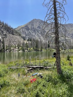
This camp was obviously way closer to the lake than the rangers desired. I didn't camp there, of course, but it did make for a ready-made spot to eat lunch on the shore.
The mental math told me if I just put it in 3rd gear I could press down the valley and back to the car by 5, which would leave me back at Eddyline for a pizza by 6, and I'd be home and in my own bed by 10 or so.
Had there been no obvious storm clouds to take my eye, I think I'd have stayed. I had one of the few Carl Hiassen novels I've not yet read with me to bide the time, but I wondered immediately if it would behoove me to skip back down to Henderson Gulch and be lower for camp if the storms kept pushing east. If I'd had someone else in my ear to talk me into staying, that, too, may have kept me around. But once I got moving - and made it back to the Gulch in half an hour with clearer views of the clouds building up over 'Electric Peak,' of all peaks, I decided my trip was over and I'd be in speedboat mode back to the Subaru.
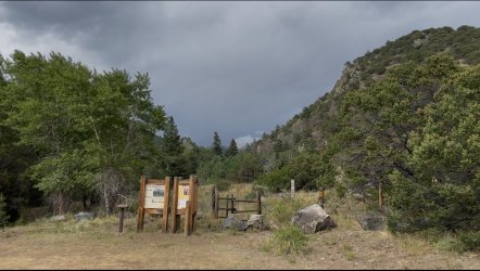
Looking back up drainage after I reached the TH at the storms that enveloped everywhere I'd just been.
Saturday became a ~12 mile day, one that took me up 1,200 feet and back down the full 3,000. It came and went in the kind of sequential fashion that made it read seamlessly, something I considered while doing it. I had not gotten stormed on. I'd not walked into a bear. I had a great campsite for my first night and picked up invaluable memories about how to hike that basin (and up to Rito Alto Lake) on any subsequent trip. I felt good, frankly, something you never can bank on as you age into this, and honestly how pretty the entire Cotton Creek drainage was made me not want a night stuck in a tent in a haily, lightning-fueled evening as part of that memory.
It's a spot I'll be back to see. It's a spot I'd love to show a friend or two, since it's not exactly the most forgiving place. It was beautiful, and I can only imagine just how beautiful it will continue to be once the dead pines serve their course in time and give way for new ones to have more of a chance.
Cheers to the Sangres!
I'd done some limited day hiking in the Sangres before, including a failed attempt at summiting Mt. Lindsey back in 2021. The steep nature of their trails and rugged mountains always piqued my interest, but for whatever reason I'd headed past them, or around them altogether when given the chance to do some backpacking in the state.
I settled on Cotton Lake as my destination this time around. If the traffic gods allowed, I could get down to the Cotton Creek TH early enough to get a ~5 PM start, and given its location on the western slope of the range I knew I'd have as much sunlight as possible to hike in. It was somewhere in the range of 8 miles up to the foot of the lake (and about 3,000 feet of steady up) and there was additional 'trail' along the Rito Alto Trail should I get any more gumption, and I settled on what should've been an easy peasy 3-day, 2-night trip.
I swung through Buena Vista on the way and hit Eddyline for a pint of courage seeing as I'd be solo this trip - I also needed a fuel canister, and hat-tip to The Trailhead for hooking me up. I've done five or seven solo overnights before and don't fear them, but I'd fallen into such a pattern of only doing trips with other folks that I'd somewhat forgotten the ins and outs until the drive down.
Anyway, with no rain in the Friday forecast and the trail as my oyster, I pulled into the TH a bit before 5 PM on Friday to find nary another car parked. It was odd to the point where I honestly wasn't sure where to leave my car, but that sorted itself quickly and off I went.

The first 1.5 or so mile traverses Rio Grande NF land before reaching the Sangre de Cristo Wilderness, and though the lower trail doesn't get much human foot traffic it's an understatement to say that it gets a boatload of cattle traffic. Cow poo was rampant, though fortunately the trail was wide enough in most places to hopscotch my way through it.
My plan was to hike in until I found a suitable site, ideally in the ~3ish mile area. That would give me plenty of time to get camp and dinner ready before dark and only have a ~5 mile push up to Cotton Lake on Saturday. I was searching for anything flat with skies open above me, though the densely packed aspen forest around the 9,000 to 9,500 foot range coincided with a steady and decidedly not-flat slope. On top of that, beetle kill had zapped so many of the pines that finding a clearing of any sort was too much to ask within eyesight of the trail, and I became resigned to the fact that hiking in further than I'd initially planned would be paramount.
Thank heck for long days, in this instance.
The first truly flat spot I found ended up featuring a wonderful site along the banks of Cotton Creek. It was readily evident that trail crew had stayed there given how many of the logs there had been sawed. While it was clear there'd been good maintenance lower on the trail before reaching that camp, I'd find out on Saturday just how much work that crew had been doing of late.

The Rito Alto up to Cotton Lake was not at all 'well used.' It was foot-in-front-of-the-other in a lot of places, with walkarounds of downed logs a built-in feature. That said, it was incredibly 'well maintained' because had the trail crew not meticulously carved through many of the places where you'd otherwise squint and grumble, you wouldn't have known there was a trail there at all. I saw nobody on this trip, and while campsites were abundant in Henderson Gulch around the 10,000 foot level, it didn't appear many had been used too often.
I wonder now if I'd simply lucked out into a) the trail crew's home base right after they'd cleared it all and b) got there before the upper trail had been cleared well enough for folks to really get up in there in 2025.
The sounds of the creek were the perfect backdrop under the eyes of De Anza Peak (13,366 ft), Electric Peak (13,573 ft), and Mount Marcy (13,494 ft). A Crank Yanker and a sit by the fire put me to sleep with the knowledge I'd push on to Cotton Lake in the morning giving me dream fuel. As I look back on the map, I knocked out about 4.7 miles and 1,800 feet of the climb on Friday, setting up just past the trail junction that takes you up Horsethief Basin and over the divide to Banjo Lake and Middle Brush Creek.

I tucked my tent into the trees on purpose knowing that they, and the 13ers (De Anza above) behind me, lay east of me. I'd be in the shade into mid-morning, the hope being I'd sleep late and avoid the mid-80s temperatures as long as possible on what otherwise was set to be a steamy Saturday.
That part of the plan worked perfectly. I slept hard until almost 9 AM, something you just don't get with a 4 year old and 2 year old running your house every other day. I was super dehydrated, something I'd feared when going to bed after such a hot walk in, and I made it a point to load up on water intake before ever setting foot on the trail that day. So, I didn't even get packed up and moving until around 11 AM, doing so under perfectly clear skies that allowed the sun to beam all over me.

It got hot in a hurry. Though I was still mostly in the trees after camping around ~10,300 ft, many of them were dead pines as I'd moved above the aspen grove. On top of that, turning around the bend to the southeast dropped me into Henderson Gulch, a spacious meadow surrounding Cotton Creek that was more sparse on trees than the densely packed lower trail. Fortunately, the trail hugged the creek through much of it early, even keeping it with frequent access points past the Middle Fork junction, and I chugged up on the final side stream in the Gulch before the trail climbed up the east wall on the ascent up to Cotton Lake.

Looking southwest with De Anza Peak (right) and Electric Peak (left) in the distance from Henderson Gulch.
The Cotton Creek drainage just below the lake and Lion Gulch at the foot were simply gorgeous even through the beetle kill. A small herd of elk was grazing a few hundred yards away in the meadows as I inched closer to the lake, and their signs (and bear scat) had been plentiful on the trek up to that point. For as dry as much of the southern portion of Colorado has been for most of 2025 (and years before), this basin was simply lush, and it's clear that wildlife both knew and appreciated that aspect of it. I'd seen a garter snake on the trail just a few hundred yards in on Friday, scared an elk in the creek basin shortly after, and the first thing I saw when I sat down at Cotton Lake was a bald eagle soaring above it.

All that and nary a human. That'll do.
The original plan had been to set up camp at the lake, and the established options up there were plentiful - even ones that were actually 300 yards away from water like the sign said. The problem was, the storms I'd seen on the forecast before losing service on Friday began to bubble up down-drainage as I ate a late lunch at the lake around 2 PM, and I began to wonder just how much I really needed to wait all afternoon just to get stormethed upon just to get up early, plow down 3,000 feet over 8+ miles in the morning, only to then still have to fight Sunday traffic on 285 back to Denver to then be a half-decent dad at my daughter's best friend's 5th birthday.

This camp was obviously way closer to the lake than the rangers desired. I didn't camp there, of course, but it did make for a ready-made spot to eat lunch on the shore.
The mental math told me if I just put it in 3rd gear I could press down the valley and back to the car by 5, which would leave me back at Eddyline for a pizza by 6, and I'd be home and in my own bed by 10 or so.
Had there been no obvious storm clouds to take my eye, I think I'd have stayed. I had one of the few Carl Hiassen novels I've not yet read with me to bide the time, but I wondered immediately if it would behoove me to skip back down to Henderson Gulch and be lower for camp if the storms kept pushing east. If I'd had someone else in my ear to talk me into staying, that, too, may have kept me around. But once I got moving - and made it back to the Gulch in half an hour with clearer views of the clouds building up over 'Electric Peak,' of all peaks, I decided my trip was over and I'd be in speedboat mode back to the Subaru.

Looking back up drainage after I reached the TH at the storms that enveloped everywhere I'd just been.
Saturday became a ~12 mile day, one that took me up 1,200 feet and back down the full 3,000. It came and went in the kind of sequential fashion that made it read seamlessly, something I considered while doing it. I had not gotten stormed on. I'd not walked into a bear. I had a great campsite for my first night and picked up invaluable memories about how to hike that basin (and up to Rito Alto Lake) on any subsequent trip. I felt good, frankly, something you never can bank on as you age into this, and honestly how pretty the entire Cotton Creek drainage was made me not want a night stuck in a tent in a haily, lightning-fueled evening as part of that memory.
It's a spot I'll be back to see. It's a spot I'd love to show a friend or two, since it's not exactly the most forgiving place. It was beautiful, and I can only imagine just how beautiful it will continue to be once the dead pines serve their course in time and give way for new ones to have more of a chance.
Cheers to the Sangres!
