fossana
Member
- Joined
- Jan 11, 2018
- Messages
- 1,082

Intro
After multiple rainy trips to the various Alps ranges, I decided to try my luck in the drier Pyrenees. The GR 11 (a.k.a.Travesía Pirenaica a.k.a. La Senda Pirenaica) is an 820km route that runs along the Spanish side of the Pyrenees from the Atlantic to the Mediterranean. On the French side of the range there the GR 10 (reportedly slightly wetter), as well as a bewildering array of other established routes that criss-crossed the GR11.
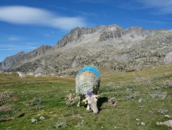
Being a Euro style trail, there are refugios, huts and small towns along the way, convenient for lodging and restocking provisions, but not so convenient for sustained days of solitude. Traditional stages end at refugios or towns to allow hikers to leave bivy gear at home, so in the mountainous regions each day often includes major elevation changes to link the lower elevation towns. In contrast to trails in the States, European trails are often straight up or down, with minimal switchbacks. A significant portion of the routes are also on dirt roads. Expect to encounter livestock in most places. While I'm a huge fan of cows and goats, seeing them in a national park was bit much.
In general trails are well-marked, but given the numerous junctions and route variations navigational aids are recommended.
Planning
the Route
Since I was less interested in the non-alpine sections, my focus would be on the High Pyrenees portion of the route, including Parque nacional de Ordesa y Monte Perdido, a UNESCO World Heritage site. I looked into overlapping with the Carros de Foc portion, but it felt like a marketing ploy by the refugios (no thanks). Lastly, I also considered doing part of the Pyrenees High Route (Haute Route Pyrénées), but with my limited timeline, the better defined GR 11 trails would allow me to cover more ground and see more things.
My planned route was constrained by the availability of public transportation and my usual vacation day hoarding. I wanted to save PTO for fall CO Plateau trips, so I limited my hike to 7.3 days. Given that I would be hiking after the end of peak season, bus routes were scaled back. I spent a few evenings researching possible options, including loops and point-to-point hikes and settled on the plan of starting at the tiny village of Aneto on highway N230 and hiking the reverse (E to W) of the traditional direction to the Canfranc Estación train stop (roughly stages 22 to 12 in the Cicerone GR11 guide). Total mileage would be ~118.5 miles over ~7.3 days, on average ~15.8 miles and ~4388 feet of gain per day.
Note: I later learned that some bus tickets are not released until just before the actual trip date and vending machines sometimes offer more stop options than online, so in the end I had more options than I originally thought.
Plan v.1.1
Once in Spain, with the start of my hike a few days off, I came down with food poisoning and was having a hard time adjusting to the time change. After consulting the forecast for the umpteenth time I decided to continue on to the next "big" town, Vielha, and postpone my start a day to avoid the heaviest rain. This turned out to be fortuitous since the bus station ticket machine allowed me to buy a ticket for a stop that's directly on the GR11, but supposedly not serviced in the off-season. This shaved off a few miles.
Lodging/Camping
Per the Cicerone guide, the one place that Spanish authorities enforce a no bivy rule is Parque nacional de Ordesa y Monte Perdido (although it is permitted at Refugio de Góriz and between Collada de Anisclo and Collada de Góriz); consequently, I made a reservation at an official campground. Otherwise bivying between sunset and sunrise (not officially the same thing as "camping") is permitted on public lands with the exception of in the immediate vicinity of most staffed refugios. In high season (June - early September) refugio and other lodging/camping reservations are recommended.
the Gear
Bivying
I did not want to stay at the refugios along the way since I can't sleep in dorms, so I carried my tent. Very few hikers I encountered carried bivy gear. Also, I had read in several trip reports that the high alpine areas were covered with a species of spiky, potentially tent/pad puncturing grass (Festuca eskia?), so I made a last minute Tyvek footprint to protect my tent floor and inflatable pad.
Maps
I downloaded the Spanish IGN topo maps to use offline with Backcountry Navigator.
Rain
As my trip departure date approached, Spain was getting slammed with the tail end of Hurricane Dorian (thanks to @Titans for the heads-up). Flooding was limited to the south, but heavy rain was forecast in the Pyrenees on the first few days of my hike mostly later in the day. I bought a last minute Snow Peak trekking umbrella and pack cover and hoped for the best.
Trip Report
Getting There
Train from Barcelona to Lleida, bus from Lleida to Vielha.


Day 1
Túnel Sud bus stop to Embalse de Paso Nuevo, Puen de San Chaime (~14.9 miles, 4428' gain)

I caught the 6am bus from Vielha and almost immediately the rain started. By the time I was dropped off in the dark by the side of the highway it was raining heavily and the wind had picked up. I crossed the highway and found a roadside kiosk to huddle under while I fished out my rain gear and tried to remember how to unlock the power button on the latest version of the Black Diamond Spot headlight. As I walked down the GR11 gravel path I had to be careful not to step on the huge toads that littered the trail. It was a comical start.
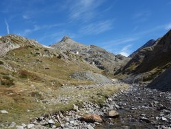
The sun rose at ~7:30am. I crossed the highway and began the long climb to Cap de Llauset. The trail was covered with slick rocks and roots, and with the wet conditions it was extra slow going. The path initially wound through the forest, following along the raging Rio Ixalenques. At least I wouldn't be running out of water on this trip.
The grade remained consistently steep, but finally plateaued above treeline. It started to rain more heavily again, so I popped into the unmanned, but well-maintained Refugio d'Anglios for a snack break. Two German hikers joined me and we chatted about tech and global politics over stroopwafels.
I popped into the fancy new Refugio de Cap de Llauset for a Fanta Limón, but none of the staff was around (a recurring theme for Spain businesses and their lax opening hours), so I continued on. After the Collado de Vallibierna pass the rain picked up again. I scoured the area for a dry spot to wait it out. My options were limited, so I had to settle for a small crevice under some boulders with my umbrella covering the entrance. After the rain backed off I continued down the valley toward Puen de San Chaime. The trail turned into dirt road, which allowed me to make up some time. A little ways before the town I found a secluded, grassy spot by Embalse de Paso Nuevo and called it a day. I was behind schedule mileage-wise, but drier weather was ahead and I could grab groceries in town in the morning. Luckily the rain let up overnight.


 .
. 


Day 2
Embalse de Paso Nuevo to Refugio de Biadós area (~17.6 miles, 4592' gain)

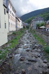
In the morning, as was the case with every morning, my tent was soaked from the dew, but fortunately, my down bag remained dry. The forecast called for sun for the foreseeable future. I left the trail and walked the road a few kilometers toward Benasque where there was reportedly a gas station convenience store. The store turned out to be one of the better ones on the entire route in terms of catering toward trail food. The owner threw even in some extra treats for the trail.
Back in Puen de San Chaime, I started the climb up Valle de Estós. The grade was much gentler than the day prior, much of it on dirt roads. At Refugio de Estós I stopped for a drink and hung my tent on the railing to dry. The refugio had a friendly resident calico cat.
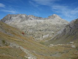
After much petting I said goodbye to my new feline friend and hit the trail for a 700m climb through lush alpine meadows filled with crocuses and plump marmots to the Puerto de Chiatsu pass. On the other side of the pass the trail descended steep, grassy hillsides below red striped peaks to Refugio de Biadós. Just before the refugio I came across an Australian shepherd puppy that was clearly more interested in attention from hikers than attending to sheep.
I arrived at the refugio just before dinner, but didn't feel like waiting around for the traditional marathon Spanish sit down meals. I grabbed a quick drink, enjoyed the last mountain views for the day, and headed down the hill to find a camping spot. The summer campgrounds were closed, so I found a hidden spot in the trees to set up my tent.


Day 3
Refugio de Biadós area to Bielsa (15.4 miles, 2952' gain)

Another morning, another wet tent. I walked along the dirt road for a little ways, paralleling Rio Zinqueta until the road split off toward the first pass of the day. Along the way the road I passed a hut that from the outside looked nice enough to be a private cabin, complete with an outdoor patio set. Had I known of its existence I would have tried to stay there.
Near the pass the singletrack returned. I continued through the alpine meadows to the final pass of the day, Collado de Urdiceto. On the other side of the pass the double-track returned. On the way down I ran into some Czech hikers, also with a tent. We chatted for a bit about other trails of interest. Of note is that they had done the Transcaucasian Trail through Georgia, another route I had considered instead of the GR11. I mentioned that I was worried about making up a day+ worth of mileage after my rain delay; they suggested that from the next town (Parzán) instead of taking the GR11 I should walk to the following town and hitch a ride to Refugio de Pineta. They mentioned that the climb from Refugio de Pineta was particularly difficult. I also knew that my planned mileage for segment was already quite long (~20 miles).
I continued down the road to Parzán. Before heading onward to Bielsa, I briefly caught up on news and found a hotel room online (bargain at € 45). I was also looking forward to a hot meal after days of lomo, cheese, and semi-stale bread. In Bielsa I restocked up on food and enjoyed a 3 course meal of salad, tortilla española, and lamb. My chances of hitching a ride before 9am were unlikely given how late everyone starts in Spain, so I booked a taxi. The driver said no to 6am, so I had to settle for 7.


Day 4
shuttle from Bielsa to Refugio de Pineta, Refugio de Pineta to Camping Valle de Bujaruelo (20.5 miles, 6068' gain)


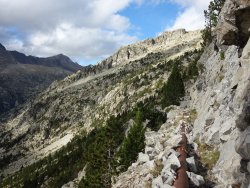
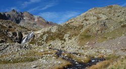
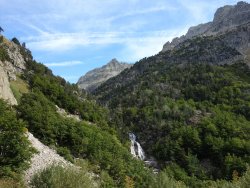
I arrived at Refugio de Pineta via taxi around dawn and started up the hill into Parque nacional de Ordesa y Monte Perdido. The climb was relentlessly steep and interspersed with class 3 scrambling. Once above treeline the views of the peaks across the valley were a welcome distraction, and I was happy to have started off the climb well-rested and well-fed. At the Collada de Anisclo pass I forgot to check my guide book and missed the contouring bypass route, and instead followed the gpx track on my topo map down into the valley along cascading falls of Río Bellos and below towering limestone walls. While incredibly scenic, it added an extra 2300' of gain for the day.
I was surprised to see sheep and goats grazing in a national park. At the Barranco Arablo drainage I climbed out of the valley past a small herd of cows and a large herd of sheep. At the Collado de Góriz pass I began the descent into the Valle de Ordesa. At the busy Refugio de Góriz I went inside for less than 5 minutes to grab a drink. When I returned to my pack my carbon trekking poles were gone. With three more days of hiking ahead, I was not livid. Fortunately, I noticed whose packs and poles were next to mine and saw that they were putting up a tent nearby. There was no way it was a mistake since they had 4 aluminum poles with them, but had gone out of there way to grab a third set, mine, which were several feet from their own. I grabbed my poles back, but neither of the couple apologized.
I left the refugio shit show and headed for the valley. I knew I still had a ways to reach the campground. After what felt like forever, I arrived at the campground, Camping Valle de Bujaruelo.


 .
. 


Day 5
Camping Valle de Bujaruelo to Ibones de Lavaza (13.7 miles, 4920' gain)

In the morning I was starting to feel crappy again, and decided I would reassess my situation and exit strategy when I reached Sallent de Gállego in 2 days. I also discovered that there were tickets for bus routes that appeared unavailable online before my trip, so if necessary I could exit the trail from the next town without a hefty taxi bill. I grabbed a quick breakfast, then hit the trail (more like dirt road). A few miles up the road Refugio de Bujaruelo was relatively busy, but once the other trails branched off, things quieted down. After another road segment, the trail climbed through a beautiful alpine valley. The cows (and lizards) here were completely unfazed by people.
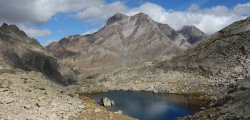
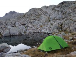
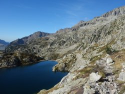
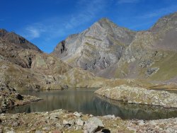
After easy walking the talus began, tempered by views of high peaks and lovely alpine lakes. I crested another pass and began the descent past the huge Ibones (Lakes) de Brazto. I kept my eye out for the huge aqueduct pipe that marked the bypass for Baños de Panticosa. I walked along the pipe until hitting a cairned junction. Some Spaniards repeatedly insisted that I take the upper path despite that it deviated from the route on my map. I thought perhaps there was a problem with my planned route (e.g. landslide or similar trail damage since the trail is precipitous in spots), so I followed their advice. It turned out to be the old GR11 route and undoubtedly took longer than my original plan since much of it was on talus. I should have known better, having had a bossy Spanish climbing partner for a few years. I ended up in a high lake basin and had another 30 minutes of daylight. The cairns eventually ended and some of the descent options cliffed out, so I decided it would be better to wait until morning to route find my way down. I found the flattest spot possible and pitched my tent, happy that I had a Tyvek groundsheet since the grass was indeed sharp enough to puncture my tent floor.


 .
. 
Day 6
Ibones de Lavaza to Sallent de Gállego (14.0 miles, 1968' gain)

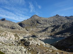
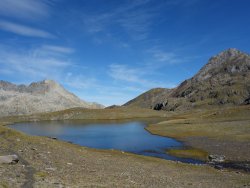
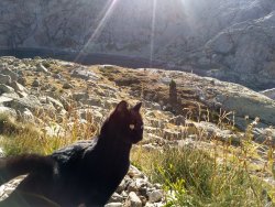
Consulting the topo map, I found a feasible descent route out of the cirque. I ended up back on the trail below Refugio de Bachimaña. A little ways past the refugio, I encountered another refugio cat, this time out on a stroll on the trails. This was obviously a sign that we both needed a petting break. I continued onward past the stunning Ibones Azules, mentally preparing myself for the talus climb to the high point of the route, the 9071' Cuello de Infierno. I kept a steady pace over the first pass and up over Infierno. I was hoping for a gentler descent, but the backside of the pass was steep scree with a hand cable for less than optimal conditions. After more steep grassy trails, the grade eased off as I neared Refugio Respomuso.
I stopped for my usual tent drying break, and grabbed an uninspiring savory sandwich and a more inspiring ice cream sandwich from the refugio. The temps started to heat up on the descent into Sallent de Gallego and I was glad I wasn't going the opposite direction. At one point I stopped to put my feet in the river, something I should have done every day. The trail alternated between dirt road and singletrack and finally I made it to the quaint village of Sallent de Gállego.
On the way to my hotel I stopped by a pharmacy, but was told I needed a prescription for antibiotics, and that I would have to wait at least 2 days to see a doctor since no one in the area saw patients on the weekend, plus I would need a car since the doctor was in another town. I decided it would be be best to head to a larger city with access to urgent care clinics in case my condition deteriorated, so I would cut my hike short by one day.


Departure
In the morning I took an early bus to Zaragoza, then a train to Barcelona the following day.
Hike Stats (route v.2)
Start: Túnel Sud bus stop on N230 (S of Vielha, near Refugio de Conangles)
End: Sallent de Gállego
GR11 Deviations: Left the trail at Parzán to walk to Bielsa. Taxi from Bielsa to Refugio de Pineta.
Total mileage: ~96 miles
Total days: 6
Daily average mileage: ~16.0
Daily mileage range: ~13.7 to 20.5
Daily elevation gain: ~4154'
Daily elevation gain range: ~1968' to 6068'
High point: 9071'
Route on Caltopo
Overall Perception
While it was an interesting experience, it's probably not something I would repeat in the near future. Coming from years of Sierra and Colorado Plateau exploration, I missed the remoteness. Timing-wise, however, I was happy that I had not attempted this in peak season. I might still consider Transcaucasian Trail since it's less popular and there's far less infrastructure.
References
Attachments
-
 DSC00127.JPG381.7 KB · Views: 21
 -
 DSC00572l.jpg306.3 KB · Views: 18
 -
 DSC00590.jpg2.3 MB · Views: 18
 -
 DSC00592.jpg2 MB · Views: 19
 -
 DSC00599.jpg2 MB · Views: 18
 -
 DSC00604.jpg2.1 MB · Views: 18
 -
 DSC00607.jpg113.7 KB · Views: 16
 -
 DSC00607l.jpg442.5 KB · Views: 15
 -
 DSC00611.jpg2.2 MB · Views: 15
 -
 DSC00623.jpg1.8 MB · Views: 15
 -
 DSC00629.jpg2 MB · Views: 18
 -
 DSC00635.jpg2.3 MB · Views: 16
 -
 DSC00637.jpg2.2 MB · Views: 17
 -
 DSC00645.jpg2.4 MB · Views: 19
 -
 IMG_20190927_102635119_HDR.jpg1.9 MB · Views: 21
 -
 IMG_20190927_201122716_HDR.jpg1.5 MB · Views: 21
 -
 IMG_20190929_133835012_HDR.jpg328.9 KB · Views: 20
Last edited:
 . Can't say I'm surprised, I had a similar experience.
")