January 2025 finds me in Baja and here is a long trip report of what happened.
To see about my other El Camino Real hikes you can read about the 2022 hike here, or the 2023 hike here, or the 2024 hike here.
This year will probably be my last attempt hiking this section of the trail and this will probably be broken up into 2 or 3 posts.
A Little History
It was just a little over forty years after Columbus 'discovered' the New World in 1492 that Europeans had made it to what is now called Baja California.
It was then another 160 years before anyone came to stay. The Jesuits arrived in 1697 and started a chain of missions, numbering 17 in total, from San Jose del Cabo in the south to Santa Maria in the north before being kicked out of Baja by the King.
The last three missions the Jesuits established were Santa Gertrudis, San Borja and Santa Maria, with Santa Maria being the last and furthest north of the Jesuit missions. Santa Maria was never really completed like the other missions before it, being made out of adobe and the Jesuits being expelled within a year or so of it's founding in 1766.
Why this would matter to a backpacker like me is that the Jesuits had not only built some of the finest missions in Baja out of stone, they had also built a series of 'roads' tying them all together. Even today you can see sections of the 'roads' they built on Google Earth. Today those trails through the desert are called the El Camino Real. Over the intervening 250 years portions of the El Camino Real have been kept open by 49's heading to upper California during the Gold Rush, local ranchers, and the occasional person that decides that they want to travel along it.
From Santa Gertrudis to San Borja is a remote and poorly documented section of the El Camino Real that would be perfect for hiking if it could be retraced. Harry Crosby wrote in his 1974 book, The King's Highway in Baja California “The trail ahead to Mission San Borja was a total mystery, as not one of early travel accounts was conclusive.”
In early 1906 Arthur W. North traveled from San Borja to Santa Gertrudis and wrote about it in his 1910 book Camp And Camino In Lower California. He followed what what could be considered the Gulf route via Los Flores, the current town of Bahia de los Angeles not yet being a town.
North describes possible sections of the Gulf route of the El Camino Real as such “From San Borja, the Laird and I journeyed northwesterly and then northeasterly, finding faint signs of an ancient and very broad highway, marked by lines of stones on either side, lines which must have been surveyed with every care.” (Camp And Camino In Lower California, page 123) and “In places we saw parallel lines of stones marking the ancient and now unknown Gulfo Camino of the Padres;"(Camp And Camino In Lower California, page 132)
I tried in 2023, 2024 and again in 2025 to follow parts of this historic trail with varying degrees of success..
Over the last two years I believe that I had worked out the easiest and most practical route to follow and 2025 was going to be the test of how well I have done my research. My 2025 hike was going to be over much the same ground as the 2023 and 2024 hikes had covered.
Heading South
Leaving work early, I got a much needed hair cut before heading south on Thursday. The sun sets early in January and darkness finds me in the Mohave desert that first night. Pulling of the highway and down a series of dirt roads, I find a place to park and roll out my sleeping bag in the back of the car.
Friday has me on the road early and in Calexico by noon. I do some last minute shopping, fill up with gas, get some lunch and exchange Dollars for Pesos before heading to the border crossing.
After one of the quickest border crossings I can remember, I am dumped into Mexicali, a city much different to it's sister city north of the border, and try to navigate my way to San Felipe through the chaotic traffic. There seems to be a larger then normal security presence in town, with the police, the military and the National Guard out all over town.
It isn't long before I am on Highway 5, with a 125 miles of good pavement to San Felipe streched out before me. The highway takes you on a raised causeway across the normally dry playa of Laguna Salada, past the sand dunes near El Oasis and on to the military checkpoint at junction of Highway 3 and 5, where I am waved through without the usual inspection.
HIGHWAY 1 IN BAJA

At San Felipe I fill up, even though I have almost 3/4's of a tank of gas left. There are only 2 gas stations in the 220 miles between San Felipe and Jesus Maria and they are both in the first 100 miles, better to start full, than to worry about fuel.
Darkness finds me near the new Coco's Corner and I am behind several pickups each pulling a trailer with no lights up the grade and over to Laguna Chapala, where I pull off for the night.
Driving on Laguna Chapala, or any large playa, at night is disorientating. Other than the ground in front of you, your headlights do not reach anything to illuminate and all you see is blackness. It is really an odd sensation, straining to see something, anything, and yet all you see is a wall of blackness, it is almost as if the blackness is something instead nothing. The good part is that you can stop anywhere and setup camp, which I do.
Saturday, day 3, again finds me on the road early and at the next Military checkpoint I am again waved through without an inspection. On this trip, not once will I have to exit the car while it is being searched. This section of pavement from the junction of Highway 1 and 5 to Jesus Maria has some of the worst potholes.
It is just before noon when I arrive at Jesus Maria where I make a decision to only get $300 pesos worth of fuel, little did I know how that would come back to haunt me in a few days. Last thing I do before leaving town is to get some tacos from Kassandra's.
It is 12 miles south of Jesus Maria where I turnoff onto a dirt road. From here it would be 45 miles of dirt roads to reach Rancho Los Corrales where my hike would start and 100 miles of dirt roads before I would reach pavement again in 5 days.
DIRT ROAD INTO THE MOUNTAINS TOWARDS RANCHO LOS CORRALES
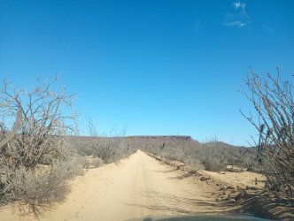
My third night finds me setting up camp about 6 miles from Rancho Los Corrales, and as I am setting up camp Francisco from Rancho Nuevo suddenly pulls up. After introductions are made, he suggests that I camp at his rancho, it would be safer and that he was heading to Guerrero Negro and would be back in the morning. I decline, saying this spot will be fine for one night. He says I am welcome to camp there if I change my mind and he leaves in a cloud of dust for the two hour drive to town.
The Mexican Rancho
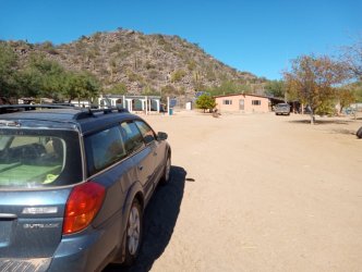
Sunday morning also finds me on the road early, driving the few miles to Rancho Nuevo and then a couple more miles to Rancho Los Corrales. I am a little apprehensive about pulling up to Rancho Los Corrales. I know the owner speaks no English and I do not know enough Spanish to ask if I may park there for a few days while I go hiking.
It goes better than I hoped and he again allows me to park, after insisting I park in his yard. He opens his gate and I pull in and park. After a few minutes of us awkwardly trying to communicate to one another, I am off and this year the ranch dog stays home.
RANCHO LOS CORRALES
On the hike between Rancho Los Corrales and Rancho Tres Palmas has me thinking about the rancho's place in Baja exploration. Most written accounts of Baja will mention rancho's that they passed or visited, often with the rancho using the same name even with what appears to be different owners.
Harry Crosby says “In an hour we came to Rancho Nuevo and accepted the kind offer of the rancher, Jesus Aguilar, to spend the night under his roof.” (The King's Highway In Baja California, page 139).
Perhaps Francisco's last name is Aguilar and the rancho was passed down from father to son, I do not know. Crosby's book was published in 1974, so even if Jesus was a young man of twenties when Crosby spent the night under his roof he would be well into his seventies today.
Edie Littlefield Sundby writes, “We arrived at Los Corrales at sunset. It was the only rancho from mission times still inhabited. The vaquero, Francisco, and his wife, Ana greeted us at the gate.” (The Mission Walker, page 210).
Only problem is that Juan is at Los Corrales and Francisco is at Rancho Nuevo. Crosby shows Rancho Nuevo on his map of the area, but doesn't show Los Corrales, suggesting that Rancho Nuevo is the older of the two. Probably just a mix up of the two rancho's on her part.
A few miles into my hike I approach Tres Palmas. Harry Crosby's writing on Tres Palmas is in stark contrast to what you see today. “Soon after the trail fork we came to Rancho Tres Palmas.” (The King's Highway In Baja California, page 139). I was unsure of the trail fork he mentions until it struck me as I was writing this. On this years adventure I followed a new section of trail that I had not been on the last two years and there is a prominent fork in the trail that I thought, “I wonder where that trail goes?”. Crosby mentions two ranchos down the left fork and one of them, La Huerta, is shown on my older Baja Almanac.
About Rancho Tres Palmas he writes, “However poor, it was rather a idyllic place because of a generous water supply and beautiful surroundings.” (Harry Crosby, The King's Highway In Baja California, page 139). He then goes on to say that they had a nice garden and clean, well fed domesticated animals. The rancho was being run by Pancho Romero and his mother, who tamed birds and even handed a mourning dove to Harry Crosby to hold.
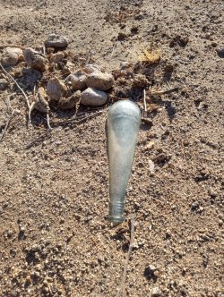
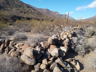
Edie Littlefield Sundby does not mention Tres Palmas at all, most likely because it is mostly reclaimed by the desert. Walking around the site today you will only see some scattered artifacts and the remains of a stone corral.
OLD BOTTLE AT THE ABANDONED RANCHO TRES PALMAS
REMAINS OF THE CORRAL AT TRES PALMAS
Evening finds me the farthest along the hike I have ever been on the first day. I was hoping to be a little further on but the sun was setting. I set up camp near where I believed the old trail would have left the arroyo to San Sebastian.
Scare in San Sebastian
Today is going to be a make or break day. If I am able to find the trail that I believe leaves the arroyo near here it will save hours of hiking today. The arroyo between here and San Sebastian makes a large curve, looking like a giant, backwards letter 'C'.
J. Ross Browne in his 1869 book 'A Sketch Of The Settlement And Exploration Of Lower California' has this to say about this section of the trail 'The ascent of the latter canyon was extremly bad. It was full of large rocks and quicksands; the trail, if any ever existed, had been completely washed away…' Having experienced the quicksands and large boulders in the previous years hikes I was eager to find a alternate route.
I start looking for a trail, finding one that looks promising I start up and out of the arroyo. Following the trail up and over a low pass it becomes slightly more defined. I follow it for some time when I come upon a junction.
I go to the left and for a little while it seems to head in the right direction as it goes up a hill. As it climbs higher and higher it also starts curving to the south. It soon becomes clear that this trail is leading me in the wrong direction and I am forced to backtrack to the junction.
Back on the right-hand fork I am heading in the right direction. Occasionally the trail fades out and I am forced to work my way through the thorns. I am not sure which plant is worse.
There is a type of agave plant with their 2 inch long spike tipping their rosette of leaves, all at the perfect height of stabbing you in the calf when you try to step over them.
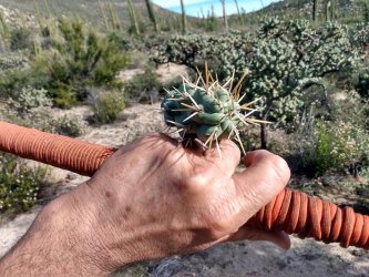
Of course there is the every present cholla, you will occasionally see the cows of Baja with sections of this type of cholla cacti stuck to them. I carry a pair of Leatherman pliers to pull them off of me. I have had several stuck to me on this hike.
A CARELESS MOMENT LEADS TO A PIECE OF CHOLLA STUCK IN MY HAND
There is also a variety of the mesquite tree, tipped with long thorns that are at the perfect height for stabbing you in the chest and in the face if you are not careful.
A LARGE CARDON CACTI WITH SOME MESQUITE BRANCHES SHOWING THE WICKED SPIKES ON THEM

The most annoying is a what appears to be a type of prickly pear cactus and while it has the normal long spines, what is worse is the small and very fine barbed spines that come off in groups of 15 to 20, called glochids, it is almost impossible to remove all of them.
While working my way towards San Sebastian I run out of water. I am not too concerned with being out of water because San Sebastian is a pretty reliable source of good water.
After an hour of working my way through some nasty thickets I come upon a good trail heading directly for the corral at San Sebastian and it is not long before I arrive.
Crosby in his book The Kings Highway In Baja Calfornia says this about the place “San Sebastian was a beautiful spot in the form of a natural amphitheater with large granite boulders scattered about.” While a hundred years earlier J. Ross Browne in his 1869 book wrote “...and, what was more desirable than either, a flat of several acres, almost free from stones, and with a profusion of excellent grass.” (A Sketch Of The Settlement And Exploration Of Lower California, page 104). Today it is much the same, maybe not as much grass, but still an idyllic spot.
Both Browne, in the 1860's, and Crosby, in the 1970's, describes a house of sorts. Browne says “...a pretty fair shanty of palm-leaves,...” and because they were stuck there for the next couple of days due to rain he says “the house being somewhat out of repair, we were obliged to mend it; the whole party went to work collecting palm-leaves and patched up the old roof until we made a very respectable shelter of it.” (A Sketch Of The Settlement And Exploration Of Lower California, page 104). A century later Crosby says “To heighten the effect, the ranch house was poor and primitive in the extreme.” (The King's Highway In Baja California, page 140). The ranch house is long gone, with just some artifacts scattered about and items that are still used by the occasional visiting cowboy are hanging in a mesquite tree.
REMAINS OF THE RANCH HOUSE AT SAN SEBASTIAN

GEAR LEFT IN A MESQUITE TREE BY LOCAL RANCHERS FOR FUTURE USE

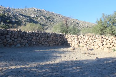
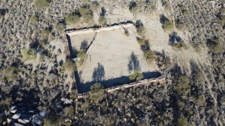
Crosby also mentions a corral, he says “The principal structure was a massive corral laid up of large pieces of the native rock.” (The King's Highway In Baja California, page 140). The corral has stood the test of time and is still standing, with walls a full 6 feet tall and in perfect shape.
THE LARGE CORRAL AT SAN SEBASTIAN
Both Browne and Crosby reached San Sebastian either during or shortly after the area received some heavy rain. Browne says “We were detained here for the next two days by rain...” ( A Sketch Of The Settlement And Exploration Of Lower California, page 104) and Crosby said “That night it really rained, the only rain of the entire trip” (The King's Highway In Baja California, page 139). Interesting that Crosby makes no mention of the quicksand that Browne mentions, and that I also ran into on my 2023 trip.
Also to note that while traveling between San Borja and Santa Gertrudis via the Gulf route North also writes about rain. After leaving Los Flores North writes “A rainstorm soon burst upon us and continued unceasingly,...before darkness and the pelting storm compelled us to halt.” (Camp and Camino In Lower California, page 131)
Throwing off my pack and grabbing all my water bottles I head down to the arroyo to quench my thirst and stock up on water. Based on what I have seen in previous years and what has been written I was not concerned about finding water. Browne notes that “Here we find a fine stream of water...” (A Sketch Of The Settlement And Exploration Of Lower California, page 104).
I follow the trail from the site of the old ranch house down to the arroyo and I am dismayed to see no signs of water. Walking upstream to the pool where I filtered water last year I find it dry as a bone. I am a little concerned as I head up stream looking for water. I soon come across more dried up pools but the soil is damp, which I take as a good sign as I continue upstream.
WATER AT SAN SEBASTIAN
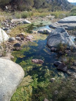
It isn't long before I find standing water and continue walking upstream until I find a nice pool with no signs that horses or cows have been in it. After drinking my fill and filling up most of my water containers I head back to my pack to continue on my journey.
TO BE CONTINUED......Here you can find PART TWO
To see about my other El Camino Real hikes you can read about the 2022 hike here, or the 2023 hike here, or the 2024 hike here.
This year will probably be my last attempt hiking this section of the trail and this will probably be broken up into 2 or 3 posts.
A Little History
It was just a little over forty years after Columbus 'discovered' the New World in 1492 that Europeans had made it to what is now called Baja California.
It was then another 160 years before anyone came to stay. The Jesuits arrived in 1697 and started a chain of missions, numbering 17 in total, from San Jose del Cabo in the south to Santa Maria in the north before being kicked out of Baja by the King.
The last three missions the Jesuits established were Santa Gertrudis, San Borja and Santa Maria, with Santa Maria being the last and furthest north of the Jesuit missions. Santa Maria was never really completed like the other missions before it, being made out of adobe and the Jesuits being expelled within a year or so of it's founding in 1766.
Why this would matter to a backpacker like me is that the Jesuits had not only built some of the finest missions in Baja out of stone, they had also built a series of 'roads' tying them all together. Even today you can see sections of the 'roads' they built on Google Earth. Today those trails through the desert are called the El Camino Real. Over the intervening 250 years portions of the El Camino Real have been kept open by 49's heading to upper California during the Gold Rush, local ranchers, and the occasional person that decides that they want to travel along it.
From Santa Gertrudis to San Borja is a remote and poorly documented section of the El Camino Real that would be perfect for hiking if it could be retraced. Harry Crosby wrote in his 1974 book, The King's Highway in Baja California “The trail ahead to Mission San Borja was a total mystery, as not one of early travel accounts was conclusive.”
In early 1906 Arthur W. North traveled from San Borja to Santa Gertrudis and wrote about it in his 1910 book Camp And Camino In Lower California. He followed what what could be considered the Gulf route via Los Flores, the current town of Bahia de los Angeles not yet being a town.
North describes possible sections of the Gulf route of the El Camino Real as such “From San Borja, the Laird and I journeyed northwesterly and then northeasterly, finding faint signs of an ancient and very broad highway, marked by lines of stones on either side, lines which must have been surveyed with every care.” (Camp And Camino In Lower California, page 123) and “In places we saw parallel lines of stones marking the ancient and now unknown Gulfo Camino of the Padres;"(Camp And Camino In Lower California, page 132)
I tried in 2023, 2024 and again in 2025 to follow parts of this historic trail with varying degrees of success..
Over the last two years I believe that I had worked out the easiest and most practical route to follow and 2025 was going to be the test of how well I have done my research. My 2025 hike was going to be over much the same ground as the 2023 and 2024 hikes had covered.
Heading South
Leaving work early, I got a much needed hair cut before heading south on Thursday. The sun sets early in January and darkness finds me in the Mohave desert that first night. Pulling of the highway and down a series of dirt roads, I find a place to park and roll out my sleeping bag in the back of the car.
Friday has me on the road early and in Calexico by noon. I do some last minute shopping, fill up with gas, get some lunch and exchange Dollars for Pesos before heading to the border crossing.
After one of the quickest border crossings I can remember, I am dumped into Mexicali, a city much different to it's sister city north of the border, and try to navigate my way to San Felipe through the chaotic traffic. There seems to be a larger then normal security presence in town, with the police, the military and the National Guard out all over town.
It isn't long before I am on Highway 5, with a 125 miles of good pavement to San Felipe streched out before me. The highway takes you on a raised causeway across the normally dry playa of Laguna Salada, past the sand dunes near El Oasis and on to the military checkpoint at junction of Highway 3 and 5, where I am waved through without the usual inspection.
HIGHWAY 1 IN BAJA

At San Felipe I fill up, even though I have almost 3/4's of a tank of gas left. There are only 2 gas stations in the 220 miles between San Felipe and Jesus Maria and they are both in the first 100 miles, better to start full, than to worry about fuel.
Darkness finds me near the new Coco's Corner and I am behind several pickups each pulling a trailer with no lights up the grade and over to Laguna Chapala, where I pull off for the night.
Driving on Laguna Chapala, or any large playa, at night is disorientating. Other than the ground in front of you, your headlights do not reach anything to illuminate and all you see is blackness. It is really an odd sensation, straining to see something, anything, and yet all you see is a wall of blackness, it is almost as if the blackness is something instead nothing. The good part is that you can stop anywhere and setup camp, which I do.
Saturday, day 3, again finds me on the road early and at the next Military checkpoint I am again waved through without an inspection. On this trip, not once will I have to exit the car while it is being searched. This section of pavement from the junction of Highway 1 and 5 to Jesus Maria has some of the worst potholes.
It is just before noon when I arrive at Jesus Maria where I make a decision to only get $300 pesos worth of fuel, little did I know how that would come back to haunt me in a few days. Last thing I do before leaving town is to get some tacos from Kassandra's.
It is 12 miles south of Jesus Maria where I turnoff onto a dirt road. From here it would be 45 miles of dirt roads to reach Rancho Los Corrales where my hike would start and 100 miles of dirt roads before I would reach pavement again in 5 days.
DIRT ROAD INTO THE MOUNTAINS TOWARDS RANCHO LOS CORRALES

My third night finds me setting up camp about 6 miles from Rancho Los Corrales, and as I am setting up camp Francisco from Rancho Nuevo suddenly pulls up. After introductions are made, he suggests that I camp at his rancho, it would be safer and that he was heading to Guerrero Negro and would be back in the morning. I decline, saying this spot will be fine for one night. He says I am welcome to camp there if I change my mind and he leaves in a cloud of dust for the two hour drive to town.
The Mexican Rancho
Sunday morning also finds me on the road early, driving the few miles to Rancho Nuevo and then a couple more miles to Rancho Los Corrales. I am a little apprehensive about pulling up to Rancho Los Corrales. I know the owner speaks no English and I do not know enough Spanish to ask if I may park there for a few days while I go hiking.
It goes better than I hoped and he again allows me to park, after insisting I park in his yard. He opens his gate and I pull in and park. After a few minutes of us awkwardly trying to communicate to one another, I am off and this year the ranch dog stays home.
RANCHO LOS CORRALES

On the hike between Rancho Los Corrales and Rancho Tres Palmas has me thinking about the rancho's place in Baja exploration. Most written accounts of Baja will mention rancho's that they passed or visited, often with the rancho using the same name even with what appears to be different owners.
Harry Crosby says “In an hour we came to Rancho Nuevo and accepted the kind offer of the rancher, Jesus Aguilar, to spend the night under his roof.” (The King's Highway In Baja California, page 139).
Perhaps Francisco's last name is Aguilar and the rancho was passed down from father to son, I do not know. Crosby's book was published in 1974, so even if Jesus was a young man of twenties when Crosby spent the night under his roof he would be well into his seventies today.
Edie Littlefield Sundby writes, “We arrived at Los Corrales at sunset. It was the only rancho from mission times still inhabited. The vaquero, Francisco, and his wife, Ana greeted us at the gate.” (The Mission Walker, page 210).
Only problem is that Juan is at Los Corrales and Francisco is at Rancho Nuevo. Crosby shows Rancho Nuevo on his map of the area, but doesn't show Los Corrales, suggesting that Rancho Nuevo is the older of the two. Probably just a mix up of the two rancho's on her part.
A few miles into my hike I approach Tres Palmas. Harry Crosby's writing on Tres Palmas is in stark contrast to what you see today. “Soon after the trail fork we came to Rancho Tres Palmas.” (The King's Highway In Baja California, page 139). I was unsure of the trail fork he mentions until it struck me as I was writing this. On this years adventure I followed a new section of trail that I had not been on the last two years and there is a prominent fork in the trail that I thought, “I wonder where that trail goes?”. Crosby mentions two ranchos down the left fork and one of them, La Huerta, is shown on my older Baja Almanac.
About Rancho Tres Palmas he writes, “However poor, it was rather a idyllic place because of a generous water supply and beautiful surroundings.” (Harry Crosby, The King's Highway In Baja California, page 139). He then goes on to say that they had a nice garden and clean, well fed domesticated animals. The rancho was being run by Pancho Romero and his mother, who tamed birds and even handed a mourning dove to Harry Crosby to hold.
Edie Littlefield Sundby does not mention Tres Palmas at all, most likely because it is mostly reclaimed by the desert. Walking around the site today you will only see some scattered artifacts and the remains of a stone corral.
OLD BOTTLE AT THE ABANDONED RANCHO TRES PALMAS

REMAINS OF THE CORRAL AT TRES PALMAS

Evening finds me the farthest along the hike I have ever been on the first day. I was hoping to be a little further on but the sun was setting. I set up camp near where I believed the old trail would have left the arroyo to San Sebastian.
Scare in San Sebastian
Today is going to be a make or break day. If I am able to find the trail that I believe leaves the arroyo near here it will save hours of hiking today. The arroyo between here and San Sebastian makes a large curve, looking like a giant, backwards letter 'C'.
J. Ross Browne in his 1869 book 'A Sketch Of The Settlement And Exploration Of Lower California' has this to say about this section of the trail 'The ascent of the latter canyon was extremly bad. It was full of large rocks and quicksands; the trail, if any ever existed, had been completely washed away…' Having experienced the quicksands and large boulders in the previous years hikes I was eager to find a alternate route.
I start looking for a trail, finding one that looks promising I start up and out of the arroyo. Following the trail up and over a low pass it becomes slightly more defined. I follow it for some time when I come upon a junction.
I go to the left and for a little while it seems to head in the right direction as it goes up a hill. As it climbs higher and higher it also starts curving to the south. It soon becomes clear that this trail is leading me in the wrong direction and I am forced to backtrack to the junction.
Back on the right-hand fork I am heading in the right direction. Occasionally the trail fades out and I am forced to work my way through the thorns. I am not sure which plant is worse.
There is a type of agave plant with their 2 inch long spike tipping their rosette of leaves, all at the perfect height of stabbing you in the calf when you try to step over them.
Of course there is the every present cholla, you will occasionally see the cows of Baja with sections of this type of cholla cacti stuck to them. I carry a pair of Leatherman pliers to pull them off of me. I have had several stuck to me on this hike.
A CARELESS MOMENT LEADS TO A PIECE OF CHOLLA STUCK IN MY HAND

There is also a variety of the mesquite tree, tipped with long thorns that are at the perfect height for stabbing you in the chest and in the face if you are not careful.
A LARGE CARDON CACTI WITH SOME MESQUITE BRANCHES SHOWING THE WICKED SPIKES ON THEM

The most annoying is a what appears to be a type of prickly pear cactus and while it has the normal long spines, what is worse is the small and very fine barbed spines that come off in groups of 15 to 20, called glochids, it is almost impossible to remove all of them.
While working my way towards San Sebastian I run out of water. I am not too concerned with being out of water because San Sebastian is a pretty reliable source of good water.
After an hour of working my way through some nasty thickets I come upon a good trail heading directly for the corral at San Sebastian and it is not long before I arrive.
Crosby in his book The Kings Highway In Baja Calfornia says this about the place “San Sebastian was a beautiful spot in the form of a natural amphitheater with large granite boulders scattered about.” While a hundred years earlier J. Ross Browne in his 1869 book wrote “...and, what was more desirable than either, a flat of several acres, almost free from stones, and with a profusion of excellent grass.” (A Sketch Of The Settlement And Exploration Of Lower California, page 104). Today it is much the same, maybe not as much grass, but still an idyllic spot.
Both Browne, in the 1860's, and Crosby, in the 1970's, describes a house of sorts. Browne says “...a pretty fair shanty of palm-leaves,...” and because they were stuck there for the next couple of days due to rain he says “the house being somewhat out of repair, we were obliged to mend it; the whole party went to work collecting palm-leaves and patched up the old roof until we made a very respectable shelter of it.” (A Sketch Of The Settlement And Exploration Of Lower California, page 104). A century later Crosby says “To heighten the effect, the ranch house was poor and primitive in the extreme.” (The King's Highway In Baja California, page 140). The ranch house is long gone, with just some artifacts scattered about and items that are still used by the occasional visiting cowboy are hanging in a mesquite tree.
REMAINS OF THE RANCH HOUSE AT SAN SEBASTIAN

GEAR LEFT IN A MESQUITE TREE BY LOCAL RANCHERS FOR FUTURE USE

Crosby also mentions a corral, he says “The principal structure was a massive corral laid up of large pieces of the native rock.” (The King's Highway In Baja California, page 140). The corral has stood the test of time and is still standing, with walls a full 6 feet tall and in perfect shape.
THE LARGE CORRAL AT SAN SEBASTIAN


Both Browne and Crosby reached San Sebastian either during or shortly after the area received some heavy rain. Browne says “We were detained here for the next two days by rain...” ( A Sketch Of The Settlement And Exploration Of Lower California, page 104) and Crosby said “That night it really rained, the only rain of the entire trip” (The King's Highway In Baja California, page 139). Interesting that Crosby makes no mention of the quicksand that Browne mentions, and that I also ran into on my 2023 trip.
Also to note that while traveling between San Borja and Santa Gertrudis via the Gulf route North also writes about rain. After leaving Los Flores North writes “A rainstorm soon burst upon us and continued unceasingly,...before darkness and the pelting storm compelled us to halt.” (Camp and Camino In Lower California, page 131)
Throwing off my pack and grabbing all my water bottles I head down to the arroyo to quench my thirst and stock up on water. Based on what I have seen in previous years and what has been written I was not concerned about finding water. Browne notes that “Here we find a fine stream of water...” (A Sketch Of The Settlement And Exploration Of Lower California, page 104).
I follow the trail from the site of the old ranch house down to the arroyo and I am dismayed to see no signs of water. Walking upstream to the pool where I filtered water last year I find it dry as a bone. I am a little concerned as I head up stream looking for water. I soon come across more dried up pools but the soil is damp, which I take as a good sign as I continue upstream.
WATER AT SAN SEBASTIAN

It isn't long before I find standing water and continue walking upstream until I find a nice pool with no signs that horses or cows have been in it. After drinking my fill and filling up most of my water containers I head back to my pack to continue on my journey.
TO BE CONTINUED......Here you can find PART TWO
Last edited:
