THE WILDEST WILDERNESS
I’ve been curious about the vast wilderness in the Absaroka Mountains south and east of Yellowstone National Park for years. It’s a mysterious area, without much information available. The only maps are the basic USGS quads. There are two guidebooks, but one is ancient and the other is a basically just a second edition that’s a little more recent. Even a typical Google search doesn’t turn up much.
Part of the region is famous though, for being the most remote place in the contiguous United States. It’s known as The Thorofare, and some parts of it are over 20 miles from the nearest road. That’s straight-line distance. Actual hiking distance from the closest trailhead is farther yet.
Last fall, my friend Dave, from Lander, Wyoming, suggested that I check the area out. He sent me links to a few Youtube videos of the area, which captivated me. I started studying the topo maps, and I became intrigued. Internet research wasn’t productive, so I finally caved in and ordered the ancient guidebook. I ended up spending most of January researching the area. That was a bit awkward, since we had a trip to Oregon planned. I should’ve been researching Oregon, but I couldn’t focus on anything except the Absarokas.
The problem with doing extensive research was that I kept finding more and more places that I wanted to visit. I came up with a bunch of route ideas, but incorporating the most compelling destinations would require a 10-12 day trip.
Meanwhile, Christy was recovering from surgery to repair a torn tendon in her ankle. Unfortunately, the surgery didn’t work. A second surgery was scheduled for late April. The good news is the second attempt seems to have solved the problem. Unfortunately, the timing of the second surgery meant that she wouldn’t be able to resume hiking until late summer, at the earliest. We had to cancel our July trip to Oregon.
Christy was a good sport about it. She told me that I should still go without her. My initial thought was to stick with Oregon, since we already had flights booked. However, the more I thought about it, the more I realized that I was overlooking a rare opportunity. She has bad knees, so when we backpack together, I carry most of the gear and food. Six or seven days is about the most I can manage with her. Solo is a different story. Half the gear and food means being able to do a trip that is twice as long. In fact, in 2013 I did a 12-day solo trip in Glacier National Park without resupplying.
I realized that I had a rare opportunity. I wanted to do a long trip, and I actually had the opportunity to do it. I changed my flight to Denver, reserved a rental car, and began making plans in earnest.
I wanted to incorporate a number of places in my trip, including:
North Fork Falls, on the North Fork Buffalo River
The Parting of the Waters at Two Ocean Pass, where North Two Ocean Creek splits. The western fork becomes Pacific Creek, which runs west to join the Snake River, which eventually joins the Columbia River on its journey to the Pacific Ocean. The eastern fork becomes Atlantic Creek, which runs east to join the Yellowstone River, which joins the Missouri River, which eventually joins the Mississippi River on its journey to the Atlantic Ocean (Gulf of Mexico).
Bridger Lake and the Thorofare region of Yellowstone National Park.
The very beginning of the Yellowstone River.
Younts Peak, which is the tallest mountain in the Thorofare region, and one of the most remote peaks in the contiguous United States.
Ferry Lake, an alpine gem on the Buffalo plateau, featuring a long run of waterfalls on its outlet stream.
Most of all, I wanted to finish the trip with over 20 miles of off-trail hiking along the Continental Divide. Years ago, when I first heard about the Continental Divide Trail, I was thrilled. Imagine hiking the Continental Divide from Mexico to Canada! I was disappointed when I found out that most of the CDT isn’t actually on the Continental Divide. There is a good reason for this – most of the Continental Divide isn’t walkable. There are a few exceptions though. One of them is on the Buffalo plateau in the Teton Wilderness. I couldn’t imagine a more thrilling way to end the trip.
I decided that the best approach would be to start at the Turpin Meadows trailhead on the Buffalo River and finish at Brooks Lake. Going in the other direction would mean starting the trip above treeline, where hanging my food wouldn’t be possible. I planned to carry a bear cannister, but I’d never get 12 days of food in it.
This route would require a car shuttle. A loop from Turpin Meadows was also an option, but it would require eliminating something from the trip. I messaged my friend Dave in Lander, and he offered to shuttle me from Brooks Lake over to Turpin Meadows at the start of my trip. That was very generous of him, as it is a pretty long drive from Lander.
Originally I planned to hike 14 miles from Turpin Meadows to North Fork Falls on the North Fork of the Buffalo River on the first day. Although the terrain looked easy, that would be ambitious for the first day, with heavy packs and not much time to acclimate to the altitude. I feared that I was setting myself up for failure. Eventually I decided on a minor change. Instead of starting on Monday morning, I’d get a head start on Sunday afternoon. I’d knock out 4 or 5 miles on Sunday, leaving me with 10 miles or less on Monday. Since I had already labeled my maps, and I was calling Monday “Day 1”, I decided to refer to Sunday as “Day Zero”. My final plan was as follows, with estimated mileage based on the guidebook and Cal Topo map measurements:
Day 0 – Turpin Meadows to Soda Fork Meadows: 4 miles
Day 1 – Soda Fork Meadows to North Fork Falls: 10 miles
Day 2 – Layover day, hike to waterfalls in the headwaters of the North Fork Buffalo River: 13 miles.
Day 3 – North Fork Falls to Two Ocean Pass: 9 miles
Day 4 – Two Ocean Pass to Bridger Lake: 8 miles, plus side trip to Yellowstone Point.
Day 5 – Layover day, hike to waterfall on Cliff Creek in Yellowstone National Park: 10 miles.
Day 6 – Bridger Lake to the mouth of Woodard Canyon: 14 miles.
Day 7 – The mouth of Woodard Canyon to the Continental Divide: 12 miles
Day 8 – The Continental Divide to Ferry Lake: 8 miles, plus morning side trip to Younts Peak, 5 miles.
Day 9 – Layover day, hikes to waterfalls and views near Ferry Lake: distance highly variable.
Day 10 – Ferry Lake to the Continental Divide below Wall Mountain: 12 miles
Day 11 – The Continental Divide to Perry N Boday Lake: 10 miles, plus 5 mile morning side trip to the summit of Wall Mountain.
Day 12 – Perry N Boday Lake to Brooks Lake: 12 miles.
Did I mention that Christy was a good sport? She spent weeks dehydrating meals for me. This trip would’ve been impossible without them. She made me 12 dinners that weighed a little over 5 pounds.
I made another sacrifice to save weight. My DSLR camera and lens weighs 3 ½ pounds. My smallest tripod (a mini Gorilla pod) is another ½ pound or so. Eventually I decided to leave the camera at home and just use my IPhone 13 Pro for photos. It was a tough decision, as the DSLR is much better for waterfall photography. I did some experimenting with photographing waterfalls with my phone before the trip, and I decided that it would be good enough.
My next concern was how to keep my phone charged. I take A LOT of photos. I would also need my phone for maps and GPS. It would never last anywhere near 13 days. I have two portable chargers that are good for two recharges each. Each one is a ½ pound. I decided to bring both. But would that be enough juice? I had my doubts, but it was impossible to know for sure. I did some research, and found positive reviews on a Lixada solar panel. It wasn’t powerful, but it only weighed a few ounces. I decided to get one to keep my portable power bricks fully charged. Later I decided that I could easily carry two, so I bought a second one. So, two power bricks and two solar panels. They totaled a pound a half, which was still a lot less than my camera.
The only thing left was to decide if I wanted company. Part of me wanted to tackle the challenge solo. Another part of me didn’t want to be eaten by grizzly bear. In terms of safety in grizzly country, there isn’t much difference between hiking solo and a group of two. Still, there is something reassuring about having company.
Ultimately, I invited several friends, but none of them were able to join. It looked like it would be a solo trip, but Christy suggested that I consider her Uncle Larry. He had thru-hiked the Appalachian Trail, the John Muir Trail twice, and the Sierra High Route three times. He would be comfortable with long-distance hiking and off-trail travel.
I sent him an invitation, but I wasn’t sure if he would be interested. He was able to resupply every few days on most of his trips. That wasn’t an option with this trip – we’d be starting out with 13 days of food. That’s heavy, no matter how much you dehydrate.
I was a little surprised when I got his message saying that he wanted to join, but also a little relieved. It would be good to have company, and maybe not turn into bear shit. Larry booked a flight into Denver, and I got us a free hotel near the airport for Friday, July 15th. We planned to meet up there and drive to Wyoming the next day.
NO SLEEP ‘TIL DUBOIS
Getting from Asheville to Northwest Wyoming isn’t easy or cheap. Flying into Jackson, Wyoming would have been more convenient, but it was horribly expensive ($1,300+) and flight options were limited. I looked at Salt Lake City and Denver. Denver was cheaper, and American Airlines could get me from Asheville to Denver with a single connection in Dallas. I’d fly out late Friday afternoon (after work), and I would arrive in Denver around 10pm. That was my best option, so I booked it, though I’m always hesitant to book flights late in the day, particularly in summer when thunderstorms are common. Flight delays and cancellations are much more common later in the day.
Christy dropped me off at the Asheville airport Friday afternoon. My flight to Dallas was smooth, and on-time. I had a 3-hour layover, so I skipped the train and walked all the way to concourse C. I had dinner at an upscale Mexican restaurant, where I got a surprisingly small burrito for $18. Inflation happens in multiple ways. Sometimes prices go up. Other times, burritos get smaller. Or both.
I strolled over to my gate a bit before boarding time. The boarding process was smooth, and everyone eventually got boarded and seated. The air conditioning wasn’t working, but the pilot assured us that it would cool off once we started moving. That was briefly reassuring. Then the power went out.
A flight attendant reassured us that the power would be back on in just a few seconds. About a minute later, the lights came on, but that was immediately followed by an announcement. “This plane is out of service. Please gather all of your belongings, disembark, and wait in the gate area.” That was met with a collective groan.
Shortly after everyone got off, dozens of phones pinged simultaneously. I looked at mine, only to see that our 9pm flight had been rescheduled to 5am Saturday. This was met with an even louder groan.
We were told to check our email, as they would be providing hotel accommodations. That wasn’t as great as it sounded. It was now well after 10pm, and our flight was rescheduled for 5am. The nearest hotel was 20 miles away, and there was no shuttle service. I would have to make my own transportation arrangements there and back. I did some quick math, and I figured that I wouldn’t get there until midnight. I’d have to leave there at 3am to get back to the airport for the 5am flight, and I would have to go back through security. Was it worth the trouble?
The flight then got pushed from 5am to 6am, but it still didn’t seem worthwhile. I might get a few hours of sleep, but I wouldn’t sleep well knowing that I’d need to get a taxi or Uber to get back to the airport. I decided to stay.
Some of my fellow passengers left for hotels, but many others just sprawled out in the waiting area at the gate. That seemed like a bad strategy to me. I was focused on avoiding exposure to Covid, as getting sick 20 miles down the trail would be a disaster. I decided to find a quieter area, away from people. I walked through about half of the C concourse, before settling on gate C-9, which was deserted. I crawled up under a row of seats, clipped my backpack to a chair post, and attempted to sleep.
I dozed off and on, but the airport was bright and loud until after midnight. It did quiet down for a few hours, but it was still a rough night. Gate C-9 of the Dallas Fort Worth International Airport was definitely the worst campsite of the trip.
American Airlines didn’t specifically say why the flight was delayed. They implied that the delay was due to a mechanical issue with the “power outage”, but in hindsight, I have my doubts. Was it a rouse? I’m guessing it was some sort of staffing issue, but they didn’t want to admit that.
The second attempt was smooth, and I landed in Denver early Saturday morning. I got a breakfast sandwich and a large coffee, picked up my luggage, and eventually made it over to Avis. Avis was a shit-show too. After a lengthy delay I picked up my car, which turned out to be a Toyota Corolla. From there I drove over to the Holiday Inn Express that I had booked using points. I wanted to get something out of it, so after meeting Larry in the lobby I went up to the room and took a shower. At least that woke me up a little bit.
Next up was the most dangerous part of the trip – the 6 hour drive from Denver to Lander, Wyoming on almost no sleep. I probably should have asked Larry to drive, but I was running strong on excitement and caffeine. Traffic was surprisingly bad leaving Denver, and there was a lot of construction on I-25. Reaching Fort Collins was as relief, as it would be all back roads from there.
We stopped at Ace Hardware to pick up stove fuel (denatured alcohol) and REI for bear spray. We had lunch and A LOT of soda at the Yampa Sandwich Company before resuming the drive north. The rest of the drive was uneventful, and we arrived in Lander late that afternoon.
We stopped at Safeway to pick up groceries and final supplies. Larry brought almost all of his food with him. I had my dinners, but I needed almost everything else. We also picked up chicken, potatoes, vegetables, and charcoal for dinner that night.
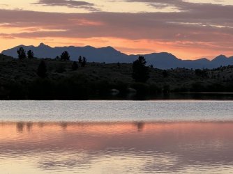
We drove another hour north from Lander. A few miles south of Dubois we took a dirt road up towards Torrey Lake. Plan A for the night was an informal, free camping area at Ring Lake. I was worried that it would be crowded on a Saturday night, but there was one good spot and some marginal spots available. We took the good spot above the lake shore, set up camp, cooked dinner, and enjoyed a nice sunset. The mosquitoes were pretty terrible, but it was a good spot to camp otherwise. I noted that it wouldn’t have worked for hammock camping, as there were only a few scattered trees. I slept well that night, but it would be a few days before I fully recovered from my sleep deprivation.

Ring Lake sunset
RING LAKE CHURCH OF GOD
Larry and I woke early on Sunday morning. I had coffee and a bagel, broke camp, and started organizing my gear for the trip. We ended up fully loading our packs there in the camping area. That way, we would know if we were missing anything. We still had to drive through Dubois to get to the trailhead, so that would be our last chance to pick up any last minute supplies.

My pack for 12 days
I was missing a travel size tube of toothpaste, regular Advil, and my camp soap bottle was nearly empty. I also had managed to break my cheap sunglasses somewhere along the way. We stopped at the small grocery store in Dubois later, where I completely forgot to buy any of those things. Fortunately, I was able to get by on half of a travel-size tube of toothpaste, and I had some stronger pain killers. Sunglasses would have been helpful, but I managed without them.
We were treated to some entertainment while we were packing. Apparently there is a full-blown church service every Sunday morning on the shore of Ring Lake, including a live band. The band was warming up while we were packing. They featured a couple of guitars, a bass, and a male and female singer. They were pretty good – we actually considered sticking around for the service. We had a lot on our agenda though, so we finished packing up and headed out.
We drove the rest of the way up Torrey Lake Road to the Glacier Trailhead. The valley is loaded with petroglyphs, and I wanted to look for them. Larry was on board with that plan, so off we went. I’d forgotten to ask my friend Dave for directions, but I had found a blog that suggested searching on the rocks near the trailhead. I tried that, but I didn’t have any luck. Larry skipped this adventure, as it was hot and sunny, and he was focused on charging his phone. He sat in the car while I wandered around.
Later I found out that they are high above the actual trailhead, in a band of cliffs visible from the parking lot.
We stopped at another place farther back down the road for a second attempt. There were some spots that looked promising, but I didn’t find anything. Later I found out that I was really close to the correct area.
We gave up on that and drove into Dubois. We stopped at small public parking lot, used the bathroom, and called our wives one last time. Then we hit the grocery store, where I completely failed to purchase any of the things I actually needed for the trip. We did get sandwiches and cold drinks for lunch, which we consumed before we left town.
We were a little ahead of schedule, but there wasn’t anything else left to do except head for the trailhead. The drive to Brooks Lake was easy, first on the main highway and then on a good dirt road. We parked at the Continental Divide Trailhead and wandered around enjoying the scenery. Brooks Lake is spectacular, with sheer cliffs to the East and West.


Brooks Lake
Dave, his friend Rose, and his hound dog Grace arrived a bit early. Dave used to live in Hendersonville, NC, and we have mutual friends, but we hadn’t actually met previously. We have been Facebooks friends for a couple of years, and I’ve enjoyed keeping up with his adventures in Wyoming. It was great to finally meet him, and Rose and Grace, in person. We chatted in the parking lot briefly, before piling into his truck. Rose went for a short hike, while Dave drove us down to the Turpin Meadows Trailhead. We talked about a little bit of everything on the ride, which took 30 minutes or so.
Dave dropped us off around 3:30 under partly cloudy skies. There were a lot of vehicles at the trailhead parking lot, but there wasn’t anyone else around. We thanked Dave again for the shuttle and hoisted our packs. Well, Larry hoisted his pack. Mine was a good bit heavier, and Dave had to help me get it on. That wasn’t a great sign! We were committed though – Dave was heading back to Brooks Lake to pick up Rose for a night of car camping. There was no going back.

Larry and me at the trailhead
I noticed a sign at the beginning of the trail that mentioned the “Yellowstone River bridge replacement project”. That was intriguing, as I hadn’t heard anything about a bridge replacement. It also sounded important, as we would need to use that bridge to get across the river. Oddly, the sign included a map noting a couple of areas that were temporarily closed to camping, but it didn’t mention anything at all about the actual bridge. That was puzzling, but I couldn’t look it up on the internet. We wouldn’t have cell service for at least the next 12 days.
Our backpacking trip started with a climb, but 10 minutes up the trail we crested the first hill. I looked back to see a spectacular view of the Tetons getting hammered by an afternoon thunderstorm. I was a little concerned that the storm would head our way....

Thunderstorm over the Tetons
We briefly followed a hillside high above the lovely Buffalo River. Technically it is the Buffalo Fork, not the Buffalo River, but later we would follow the North Fork Buffalo. North Fork Buffalo Fork sounds dumb, so I’m just calling it the North Fork Buffalo River.
A few minutes later we reached a junction with the North Buffalo and South Buffalo Trails. The South Buffalo Trail leads up through a canyon before splitting. One fork goes up to Ferry Lake, and the other heads to the Continental Divide and Perry N Boday Lake. Both of those destinations were on our agenda, but we were taking a roundabout route to reach them.
A long, grueling climb followed. The scenery wasn’t very exciting, except that the woods and meadows were full of wildflowers. The display featured an incredible variety. We eventually passed Mud Lake (without actually seeing it). A gentle descent brought us to the south end of Soda Fork Meadows. These meadows stretch for a couple of miles along the North Fork, up to the confluence with the Soda Fork.

Soda Fork Meadows
We had a tough time finding a campsite that first night. I thought Soda Fork Meadows would have plenty of options, but we didn't see anything close to the trail. We eventually found a nice one on a hillside at the north end of Soda Fork Meadows, but there was an established outfitter camp already there. Although it is a federally designated wilderness area, some outfitters set up elaborate campsites at the beginning of the summer and remove them after hunting season. There wasn't anyone around, and we thought about camping there anyway, but we couldn't be sure that the "owners" wouldn't show up later that evening.
Instead, I scouted a faint trail heading towards the river. After a few minutes I noticed a decent spot in a strip of woods between the river and a small meadow. There was no view, but it was close to the river and more sheltered. That proved to be advantageous, as violent thunderstorms rolled through at dusk. At one point there was lightning and thunder on all sides of us, but we only got a little rain down in our little hole by the river. The storm passed quickly, and I slept great, serenaded by the river.

Camp One, North Fork Buffalo north of Soda Fork Meadows
PURPLE YELLOW RED AND BLUE
We got up early on Monday and settled into our typical morning routine. To summarize, I’d spend 2 hours making oatmeal and coffee and packing up. Larry needed less than half of that time to eat some sort of bar and pack. What can I say? I like coffee, and I’m slow in the morning.
We had gone a bit out of the way looking for a campsite the previous evening. I didn’t want to backtrack, so we attempted to follow a faint trail that is shown on the map. It appears to be the route of the Continental Divide Trail, but the actual CDT may be in a slightly different place. We climbed a steep hillside away from the river, and the faint path disappeared in a meadow. Instead of wasting time and energy looking for the trail, we just headed cross-country through the meadow to the North Buffalo Trail. That worked, and before long we were back on the horse highway.
After a short distance, we reached the point where the trail curves away from the river and begins a major climb. The river runs through a canyon, which the trail avoids. I was curious about the canyon, and I wanted to get a look at it. We stopped for a break, and Larry decided to skip the side trip. I wasn’t disappointed, as that meant that I could leave my pack there with him. I made short work of the side trip. There were a ton of fallen trees, and it was a minor achievement reaching the top of a hill with a mediocre view of the canyon. From my vantage, I could see a lot of whitewater and even more dead trees. There were many standing dead trees, and many more on the ground. Getting a closer look at the canyon would’ve been a major undertaking, and it didn’t look like it would be worth the trouble. I rejoined Larry and we resumed the hike.
The stunning flower show continued. Someone recently asked me if I had ever seen a super-bloom. My initial response was, "yes, almost every summer". We plan our trips out West in late July for practical reasons, but one benefit is that we usually catch the annual flower show at its peak. Almost every year is great, but this year’s was the best I've ever seen. Our timing was perfect. We started our backpacking trip at a relatively low elevation, where the woods and meadows were covered with flowers. From there, we gradually climbed higher, following the bloom. Almost every day featured a spectacular flower show, with a tremendous variety.

Geraniums
We eventually crested a big hill and made a brief descent into vast North Fork Meadows. This is a lovely stretch of trail, close by the river. Early on we passed a really nice campsite in a stand of trees. That was the kind of campsite I’d hoped to find in Soda Fork Meadows the previous evening.

North Fork Meadows
There were a few people fishing the river near the campsite. We passed a family returning from a day of fishing the previous day, too. Other than that, there were only a couple of horse parties. One was a National Forest work crew, and the other was an outfitter. We chatted with the outfitter briefly. He asked us where we were headed. That was surprisingly difficult to answer, so I just went with where we were heading over the next couple of days. I told him that we were planning to hike to the headwaters of the North Fork to see all of the waterfalls. He raised an eyebrow at that and said, “good luck”. That seemed ominous.
We enjoyed a long, easy walk through North Fork Meadows. It was a cloudy morning, which made for more dramatic scenery. The river and trail curved East, and the meadows were slowly replaced by forest. Before long we reached a campsite and a major junction. The North Fork Two Ocean Trail continues ahead there, up a long, steep climb. We would get to do that on Thursday. For the time being, we were continuing up the North Fork on a less-traveled trail.


North Fork Meadows

We were not entirely alone out there
The scenery was a bit subdued. There were some views of the cliffy ridges on either side of the valley, but the views were diminished by thousands of standing dead trees. Apparently the valley was ravaged by a wildfire at some point in recent years. There was one particularly nice stretch though, after the trail left the river to climb over a ridge.
Shortly after that I spotted a side trail leading towards the river. I followed it down to a lightly used campsite with a nice view up the valley. I was tempted to camp there, but I really wanted to camp at or near North Fork Falls. I returned to the main trail and caught up to Larry, who had just passed by.
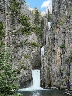
We hiked another 20 minutes before we could hear the roar of the waterfall in the distance. The trail began to climb, before meeting an obvious side path leading down towards the river. We followed it down a moderately steep hill to the base of spectacular North Fork Falls.

North Fork Falls
Following the river downstream would’ve meant wet shoes, and I didn’t want to get my boots or camp shoes wet. Instead, I climbed back up the spur trail and bushwhacked through the woods towards the point I’d picked out. The flowers were incredible in this patch of woods, and I stumbled upon the first batch of monkeyflowers of the trip.
I eventually popped out right at the spot I had aimed for. From there, I had a great view of the cliffs and three levels of the waterfall. The waterfall is much bigger than it appears from the base, as the majority of it is hidden from view.

All 3 levels of North Fork Falls
I spent a bit of time experimenting with a tiny tripod I’d purchased to hold my phone. It seemed like a good idea, but the reality was a different story. The mount was just barely big enough to hold my phone in its case. Or not. I was taking photos when the mount popped off the tripod. My phone fell right into the river. Luckily it landed in a shallow pool, and these newer phones are waterproof.
I had hoped to camp near the base of the waterfall, but the terrain wasn’t conducive to tent camping. There was one possible spot along the spur trail, but it was marginal, and there were a lot of standing dead trees around it. It was a windy afternoon, and it looked like one of those trees could come down at any moment.
Larry and I debated our options. I’d read that there were campsites in the first meadow upstream from the waterfall. It was either that or backtrack 20 minutes to the site I’d spotted earlier. We decided to continue up. That turned out to be one of the best decisions of the trip.
The climb was steep but mercifully short. We eventually crested the hill, and I spotted a flat, open area down below. There was even a side trail heading down to it. We decided to check that out.
We arrived on a flat, open knoll near the brink of the falls. You could camp a small army there, and we nearly started to set up. However, the wind was howling across the open hillside. We decided to see if there was a more sheltered spot closer to the river.
There was. Tent site options were limited, but the spot was spectacular. We were just upstream from the very brink of the waterfall. The roar was incredible, and there was a nice view down the valley, too.
We set up camp, and I did a little exploring. I wandered along the tops of the rock towers on the edge of the plateau, overlooking the waterfall. North Fork Falls is even more spectacular than I realized. It starts with a cascade and a small drop, before a monster plunge into a slot canyon. After a short run through the slot, it cascades over the final double-drop and into the pool at the base. Most of this was visible from various vantage points near our campsite. The most spectacular spot was the final rock tower that was accessible. From that point there is a mind-blowing view of the upper waterfall.


North Fork Falls - upper section
Before the trip I’d only seen photos and videos taken from the base. Those looked impressive, but I didn’t realize that I was only seeing a small part of the waterfall. If you ever visit this waterfall, be sure to hike to the top and explore around. You don’t want to miss any of this one.

Sunset panorama