- Joined
- Aug 9, 2007
- Messages
- 12,955
October in Glen Canyon. No more monsoons, no more people, and if you're lucky like we were, it's still plenty warm. High 80's with water temps in the mid 70's. Doesn't get much better than that.
Our goal for this trip was to get into the canyons of the Escalante. Davis Gulch, Fiftymile, Clear Creek, Willow. But first, we needed to find a campsite. There aren't that many in the Escalante Arm, but there was one I really wanted. The sand dune near Gregory Natural Bridge (submerged) in Fiftymile Creek. That would be the perfect setup for hiking Fiftymile with the kayaks the next day. But unfortunately, the site was taken. But luckily, there was still just enough water to get past the sand dune and into the rest of the submerged section of the canyon. At water levels below about 3600', the sand dune blocks boat access to the rest of the canyon. The water connects through the gargantuan submerged opening of Gregory Natural Bridge.

We took advantage and continued up canyon until we were only in about 6 feet of water. A small piece of sand made it possible to beach where we found a small campsite, but no beach. It was a nice place for us to stop and swim, but a poor place to let Nikita's obsession with trying to catch fish grow.

@lostlandscapes surprising the dogs that followed him up there like it was time for a hike.


After a soak, we headed back out to the Escalante and motored up toward Willow Gulch. We found a couple nice sites just upstream from Willow and settled in. There were nicer spots in the canyons still available, but we wanted to have a bit more sun exposure with the cooler fall temperatures.
After setting up camp, we went up into Willow Gulch to see what there is to see. Near the end of the lake, we encountered a massive alcove that beckoned exploration. Decoration on the beach indicated this was popular with house boaters.

Ridiculous amounts of graffiti on the walls here. I don't care if it's under high water mark, if you're the kind of parent that tells your kids this is okay, then you SUCK (to put it in the kindest words humanly possible). The graffiti lined the walls up to about 8 feet high and for hundreds of feet.

The alcove had a weird trail-like path up the back side consisting of soft, powdery sand. Almost like dust. Were it not for the lake, I'd wager that this stuff hadn't gotten wet in thousands of years.

The 'trail' climbed high up the back of the alcove, eventually blocking out the view of the sky. This alcove is like nothing I've ever seen before. And once you get to the back of it, another nice sandy walkway leads through rocks on each side to the tip of the talus pile inside. That's @markj standing up there on top.

We stopped at the top and took in the view. I couldn't help but dream about what Willow Gulch must have looked like here just 60 years ago. I'll take a guess from what I know of the rest of the canyon though. An idyllic stream lined with cottonwoods, willows and prickly pear, perhaps. I'd even bet there were some nice ruins or rock art down here. In this very cave, maybe. I can't imagine a spot like this wasn't special to others.

@audraiam reading graffiti on the walk back down.

After the alcove, we took a cruise up Bishop Creek. It was beautiful and we made it to the end this time. The sky was overcast and I didn't take many photos. That's one I'd really love to come hike sometime.
The next morning we had breakfast, threw the kayaks in the boat and motored back to Fiftymile. We didn't get an early start, but thanks to the calm weather and lack of people, the water was still total glass. It's dizzying sometimes to float around in this stuff.

We utilized the same spot we stopped to swim the previous day to anchor the boat and prepare the kayaks. Audra stuck around and took a long nap while me, Sage, @lostlandscapes, @drcleff, @Britnee, and @markj proceeded up into Fiftymile.

Everything in the area had flooded days earlier, and the debris floating near the end of the lake was a good reminder of that.

Notice the other kayak in the distance.

We eventually got hung up on flood debris to the point that we could not keep paddling. I was more than a little worried what would happen when we went to step out of the boat though. The last time I was here in 2013, I about got stuck in quicksand/mud/silt as we approached the lake.
But this time it was pretty solid underneath. We beached the boats, put on backpacks and started walking up the canyon. I liked this spot where clean sand had flooded out on top of the stuff covered in lake mulch.

Mandy, Britnee and Mark just above the high water mark. I think I was still practically in the lake where I took this photo.

There was a big surprise early on in the hike, but I'll save that for the return trip. As we walked along, the canyon was alive. Toads hopped around in the stream while the vegetation grew thick along the side. I noticed a couple of large purple flowers up an embankment and climbed up for a better look. It turns out it was Sacred Datura! I've never seen it purple like this before. We found another bush further up that had some purple flowers and some all white. Is this something that happens at the end of the season or something? What say ye, resident wildflower expert, @xjblue?

Soon the walls closed in.

The subterranean section of the Fiftymile Creek narrows.

The narrows were sublime, but the light wasn't as friendly for photographs as it was the last time I was here. If you haven't already, I encourage you to go check that trip report out.

Just as we got to this point in the canyon, we heard a loud crack from above. It was so close and so loud. Like a gunshot almost. My first thought was a rock fall. The kind you wish you could witness in nature, but hopefully not right underneath it in a narrow slot like where we were. The scenario of dying under a pile of rocks in Fiftymile Creek flashed through my mind. We looked up to see a swirling cloud of dust curl over the rim of the canyon right above us. Phew. Nothing. But I have to admit, the more I thought about it, I don't know if I could pick a better way to go. Not today though.

Nearing the top of the narrows and the high water mark.

This waterfall marks the top of the narrows. The high water mark is just a bit above it. If the reservoir were full, this would all be gone.

We stopped for lunch, and a soak/shower in the waterfall before turning back. I love this place more than I can even begin to communicate.


A very curious bit of vegetation along the hike back to the boat. You know it's good when plant master Tim looks at it like that.

Almost back to the lake. This is where we turned around in 2013.

Rather than try and retype what I have already written, I'll copy what I posted on my Facebook Page for Glen Canyon Rising, as well as the comparison photo I posted there. If you don't already, please go like that page. I promise nothing but a lot of Glen Canyon photos and the usual 'drainer propaganda' you'd get from me anyway.
Two years ago I walked Fiftymile Creek for the first time. The upper canyon is nothing short of beautiful with petroglyphs, an arch, plentiful cottonwoods, alcoves and a perennial stream. But it was the lower section that is normally under the waters of Lake Powell that really blew me away. Right as you reach the high water mark, the canyon drops into sinuous navajo sandstone narrows and starts swooping back and forth. Bend after bend of deep narrows, soaring undercuts and massive varnished walls. All with an idyllic stream running through it. Paradise.
Eventually we reached the transition zone with the lake and things started to get a little ugly. The quicksand/mud/silt was wall to wall and it was so deep and sticky that it was actually scary getting through. We turned back a little before reaching the lake out of fear that one of us could actually get stuck in the muck.
Last week I returned to Fiftymile, this time hiking up from the reservoir. Our kayaks got hung up in flood debris so we dragged them to the shore and walked the last couple hundred feet to the stream. No quicksand this time, just easy walking.
I almost didn't realize it when we came upon the place we had turned around in 2013. The ground was solid, but something else seemed different. It took me a minute to realize that the canyon bottom was at least 10 feet lower than it was 2 years earlier. All of that quicksand and mud that stopped us had been washed out by flash flooding. The desert balancing things out. We were standing once again on the natural river bed, or at least something close to it. This was no small amount of silt that had washed out. I'd guess 50-100 feet across and 10-12 feet deep for at least an entire bend of the canyon. I couldn't believe my eyes. I've never had any doubt that Glen Canyon can recover, but to see it happen so fast is just incredible. #CanyonsCanRecover
Click for larger:
Seeing all that silt cleared out was amazing. Just amazing. Anyone who thinks this place can't right itself is just plain wrong.
Walking back through the lake mulch to the kayaks.

It's not the easiest paddling through that muck.


After all that, we had bits and pieces of flood debris stuck in every nook and cranny. Time to clean off!

We may have gotten a little out of hand with the jumping off the boat photos. So much so that my wife tells me I am forbidden to ever post those photos on the internet. So instead, you get these.... Hiiiii West!


Back at camp, the boys went for a paddle. There was a tip of a log dipping around in the water all day, so we went out and brought it in for the khaleesi. Oh, hi west!

Our camp was on a small beach amongst a talus slope, so there was lots of stuff in the water. Tons of bluegill and at night, the crawfish would move in. We were watching this one and Britnee was able to scoop it out with the sauce pan. Being the drunk idiot that I am, I picked it out of there and it proceeded to pinch my finger until I bled. Well played, crawfish. I'm not sure what was worse, this, or the crawfish facial I got a few years back.

The next day we loaded up the kayaks and set out for Explorer Canyon. Audra and the old dogs stayed behind to watch the boat.

It was about 2 miles up the lake to Explorer. I wasn't sure we could get there though. Back in September it was definitely doable in a kayak. Only a few feet of water, but doable.

On this day, we once again encountered formidable quantities of flood debris.

It was all going fine until we got to right about here: 37.367470, -110.945440. We started getting grounded there. It was working out okay at first. Tim got out and I was able to paddle as he walked. But then we hit the death silt. The kind you sink into in a bad, bad way. It wasn't everywhere, but there were deep pockets here and there. The decision to abandon getting into Explorer was made quickly and soon enough Tim was dragging my gimpy ass out of there.

After blasting through a particularly thick patch of flood debris.


Back to camp after what basically was just a nice paddle. I spotted these moki steps nearby. Upon closer inspection, I'm thinking they are gringo steps. I thought maybe they were legit at first. Maybe a granary was up there before the reservoir. But then I realize that the only reason they would be at an angle like that is due to the slope of the beach here. If there were no water, you'd just go straight up. F-ing gringos...

It was quite warm, so we relaxed a bit after our paddle. Some swimming, snorkeling and a bit more paddling.

And then we decided to break out the inflatable and ride it all the way down to Clear Creek, aka Cathedral in the Desert. I've avoided tubing since we first got the boat, but damn is it fun when the water is all smooth like this! Crackin' the whip!


Mark rode the tube all the way up to right before Cathedral. I was a little concerned about bouncing him off a wall, but it was a bit of a thrill through the relatively narrow canyon (for both of us).
The Cathedral waterfall is totally submerged right now. The water level is right at the top of it, which makes hopping off and walking up to the next waterfall quite easy. Once again, some assholes stupid kids wrote shit all over the walls. Just mud this time, but seriously humans, what the hell is wrong with you?! You DO NOT need to leave your mark on everything you touch.

Happy place, happy place. Looking up in Clear Creek.


Back to the boat.

A school of Threadfin Shad hiding in the shallow water at the top of what should be the waterfall.

Heading back up the Escalante, we stopped to jump off a cliff. From left to right, Mandy, me, Tim and Mark.

A beautiful seep in the back of an unnamed side canyon of the Escalante.

Next up we stopped in Davis Gulch. For the first time I made it to the opposite side of LaGorce Arch. The water was so shallow that I had to hop out and drag it around, but that's okay. I can think of worse places to stand in knee deep water and sip on a cocktail.


LaGorce. Look closely, you can see @lostlandscapes in there working the angles.


After that we headed back toward camp, but rather than sit in the shadows, we found a bit of sun and soaked it in. After the sun went down, I decided tubing sounded kinda fun, so I hopped in and let Audra drag me around for a while. I really, really enjoy that when the water is smooth. At one point we got me, Tim and Mark all on the tube together. I don't remember all the details, but I do know that we got hucked off hard enough once that I ended up floating around wearing nothing but a life jacket. I somehow managed to catch my shorts by a toe as they came flying off. Bad cell phone shot, but you get the point.

It was another nice night staring at a star-filled sky, but sadly, it was our last. The next morning we packed up as the sun creeped down the canyon walls.

We made a couple stops: one to clean out Crape Diem and one for a quick tour of Iceberg Canyon, and then we were on our way. Nikita sat there with a satisfied grin. She had a good selection of fish to hunt for on the beach this trip. Good dog.

We cleaned up the boat and dropped it off at storage and headed home. I love not towing that thing around. Somewhere around Goblin Valley, we stopped to switch drivers and I saw this lovely sign posted near the road to The Maze. Good stuff.

Overall, this was a fine trip. More than fine. Great hiking, no assholes launching things at us, great weather, great company, great everything. The only bad thing that came of it was a curious bite I got. Midway through the trip I noticed a lump on my forearm. By the time we got home a large bruise formed in a circle around it. This is especially weird because I almost never bruise under any circumstances. Even when I get pretty serious injuries. To make it worse, the day after the trip I started feeling awful. Not like sick to my stomach or anything, but more like sleep deprived and on some sort of mystery drug. After a few days, I put the pieces together and I now believe I was bit by something like a brown recluse spider. The bruise pattern, bite mark and symptoms all add up. I'm glad I didn't get hospitalized, but man, it made for a rough week at work. My mental capacity was seriously diminished for at least a few days. Not fun. Now I'm paranoid about sleeping on my boat. Time to put in some spider traps, I guess. Back in November!
Featured image for home page:

Our goal for this trip was to get into the canyons of the Escalante. Davis Gulch, Fiftymile, Clear Creek, Willow. But first, we needed to find a campsite. There aren't that many in the Escalante Arm, but there was one I really wanted. The sand dune near Gregory Natural Bridge (submerged) in Fiftymile Creek. That would be the perfect setup for hiking Fiftymile with the kayaks the next day. But unfortunately, the site was taken. But luckily, there was still just enough water to get past the sand dune and into the rest of the submerged section of the canyon. At water levels below about 3600', the sand dune blocks boat access to the rest of the canyon. The water connects through the gargantuan submerged opening of Gregory Natural Bridge.
We took advantage and continued up canyon until we were only in about 6 feet of water. A small piece of sand made it possible to beach where we found a small campsite, but no beach. It was a nice place for us to stop and swim, but a poor place to let Nikita's obsession with trying to catch fish grow.
@lostlandscapes surprising the dogs that followed him up there like it was time for a hike.
After a soak, we headed back out to the Escalante and motored up toward Willow Gulch. We found a couple nice sites just upstream from Willow and settled in. There were nicer spots in the canyons still available, but we wanted to have a bit more sun exposure with the cooler fall temperatures.
After setting up camp, we went up into Willow Gulch to see what there is to see. Near the end of the lake, we encountered a massive alcove that beckoned exploration. Decoration on the beach indicated this was popular with house boaters.
Ridiculous amounts of graffiti on the walls here. I don't care if it's under high water mark, if you're the kind of parent that tells your kids this is okay, then you SUCK (to put it in the kindest words humanly possible). The graffiti lined the walls up to about 8 feet high and for hundreds of feet.
The alcove had a weird trail-like path up the back side consisting of soft, powdery sand. Almost like dust. Were it not for the lake, I'd wager that this stuff hadn't gotten wet in thousands of years.
The 'trail' climbed high up the back of the alcove, eventually blocking out the view of the sky. This alcove is like nothing I've ever seen before. And once you get to the back of it, another nice sandy walkway leads through rocks on each side to the tip of the talus pile inside. That's @markj standing up there on top.
We stopped at the top and took in the view. I couldn't help but dream about what Willow Gulch must have looked like here just 60 years ago. I'll take a guess from what I know of the rest of the canyon though. An idyllic stream lined with cottonwoods, willows and prickly pear, perhaps. I'd even bet there were some nice ruins or rock art down here. In this very cave, maybe. I can't imagine a spot like this wasn't special to others.
@audraiam reading graffiti on the walk back down.
After the alcove, we took a cruise up Bishop Creek. It was beautiful and we made it to the end this time. The sky was overcast and I didn't take many photos. That's one I'd really love to come hike sometime.
The next morning we had breakfast, threw the kayaks in the boat and motored back to Fiftymile. We didn't get an early start, but thanks to the calm weather and lack of people, the water was still total glass. It's dizzying sometimes to float around in this stuff.
We utilized the same spot we stopped to swim the previous day to anchor the boat and prepare the kayaks. Audra stuck around and took a long nap while me, Sage, @lostlandscapes, @drcleff, @Britnee, and @markj proceeded up into Fiftymile.
Everything in the area had flooded days earlier, and the debris floating near the end of the lake was a good reminder of that.
Notice the other kayak in the distance.
We eventually got hung up on flood debris to the point that we could not keep paddling. I was more than a little worried what would happen when we went to step out of the boat though. The last time I was here in 2013, I about got stuck in quicksand/mud/silt as we approached the lake.
But this time it was pretty solid underneath. We beached the boats, put on backpacks and started walking up the canyon. I liked this spot where clean sand had flooded out on top of the stuff covered in lake mulch.
Mandy, Britnee and Mark just above the high water mark. I think I was still practically in the lake where I took this photo.
There was a big surprise early on in the hike, but I'll save that for the return trip. As we walked along, the canyon was alive. Toads hopped around in the stream while the vegetation grew thick along the side. I noticed a couple of large purple flowers up an embankment and climbed up for a better look. It turns out it was Sacred Datura! I've never seen it purple like this before. We found another bush further up that had some purple flowers and some all white. Is this something that happens at the end of the season or something? What say ye, resident wildflower expert, @xjblue?
Soon the walls closed in.
The subterranean section of the Fiftymile Creek narrows.
The narrows were sublime, but the light wasn't as friendly for photographs as it was the last time I was here. If you haven't already, I encourage you to go check that trip report out.
Just as we got to this point in the canyon, we heard a loud crack from above. It was so close and so loud. Like a gunshot almost. My first thought was a rock fall. The kind you wish you could witness in nature, but hopefully not right underneath it in a narrow slot like where we were. The scenario of dying under a pile of rocks in Fiftymile Creek flashed through my mind. We looked up to see a swirling cloud of dust curl over the rim of the canyon right above us. Phew. Nothing. But I have to admit, the more I thought about it, I don't know if I could pick a better way to go. Not today though.
Nearing the top of the narrows and the high water mark.
This waterfall marks the top of the narrows. The high water mark is just a bit above it. If the reservoir were full, this would all be gone.
We stopped for lunch, and a soak/shower in the waterfall before turning back. I love this place more than I can even begin to communicate.
A very curious bit of vegetation along the hike back to the boat. You know it's good when plant master Tim looks at it like that.
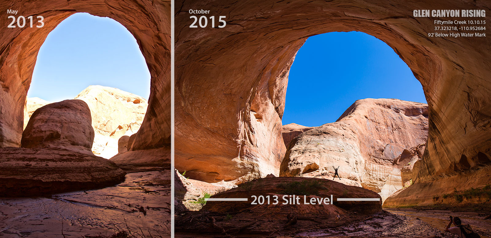
Almost back to the lake. This is where we turned around in 2013.
Rather than try and retype what I have already written, I'll copy what I posted on my Facebook Page for Glen Canyon Rising, as well as the comparison photo I posted there. If you don't already, please go like that page. I promise nothing but a lot of Glen Canyon photos and the usual 'drainer propaganda' you'd get from me anyway.
Two years ago I walked Fiftymile Creek for the first time. The upper canyon is nothing short of beautiful with petroglyphs, an arch, plentiful cottonwoods, alcoves and a perennial stream. But it was the lower section that is normally under the waters of Lake Powell that really blew me away. Right as you reach the high water mark, the canyon drops into sinuous navajo sandstone narrows and starts swooping back and forth. Bend after bend of deep narrows, soaring undercuts and massive varnished walls. All with an idyllic stream running through it. Paradise.
Eventually we reached the transition zone with the lake and things started to get a little ugly. The quicksand/mud/silt was wall to wall and it was so deep and sticky that it was actually scary getting through. We turned back a little before reaching the lake out of fear that one of us could actually get stuck in the muck.
Last week I returned to Fiftymile, this time hiking up from the reservoir. Our kayaks got hung up in flood debris so we dragged them to the shore and walked the last couple hundred feet to the stream. No quicksand this time, just easy walking.
I almost didn't realize it when we came upon the place we had turned around in 2013. The ground was solid, but something else seemed different. It took me a minute to realize that the canyon bottom was at least 10 feet lower than it was 2 years earlier. All of that quicksand and mud that stopped us had been washed out by flash flooding. The desert balancing things out. We were standing once again on the natural river bed, or at least something close to it. This was no small amount of silt that had washed out. I'd guess 50-100 feet across and 10-12 feet deep for at least an entire bend of the canyon. I couldn't believe my eyes. I've never had any doubt that Glen Canyon can recover, but to see it happen so fast is just incredible. #CanyonsCanRecover
Click for larger:
Seeing all that silt cleared out was amazing. Just amazing. Anyone who thinks this place can't right itself is just plain wrong.
Walking back through the lake mulch to the kayaks.
It's not the easiest paddling through that muck.
After all that, we had bits and pieces of flood debris stuck in every nook and cranny. Time to clean off!
We may have gotten a little out of hand with the jumping off the boat photos. So much so that my wife tells me I am forbidden to ever post those photos on the internet. So instead, you get these.... Hiiiii West!
Back at camp, the boys went for a paddle. There was a tip of a log dipping around in the water all day, so we went out and brought it in for the khaleesi. Oh, hi west!
Our camp was on a small beach amongst a talus slope, so there was lots of stuff in the water. Tons of bluegill and at night, the crawfish would move in. We were watching this one and Britnee was able to scoop it out with the sauce pan. Being the drunk idiot that I am, I picked it out of there and it proceeded to pinch my finger until I bled. Well played, crawfish. I'm not sure what was worse, this, or the crawfish facial I got a few years back.
The next day we loaded up the kayaks and set out for Explorer Canyon. Audra and the old dogs stayed behind to watch the boat.
It was about 2 miles up the lake to Explorer. I wasn't sure we could get there though. Back in September it was definitely doable in a kayak. Only a few feet of water, but doable.
On this day, we once again encountered formidable quantities of flood debris.
It was all going fine until we got to right about here: 37.367470, -110.945440. We started getting grounded there. It was working out okay at first. Tim got out and I was able to paddle as he walked. But then we hit the death silt. The kind you sink into in a bad, bad way. It wasn't everywhere, but there were deep pockets here and there. The decision to abandon getting into Explorer was made quickly and soon enough Tim was dragging my gimpy ass out of there.
After blasting through a particularly thick patch of flood debris.
Back to camp after what basically was just a nice paddle. I spotted these moki steps nearby. Upon closer inspection, I'm thinking they are gringo steps. I thought maybe they were legit at first. Maybe a granary was up there before the reservoir. But then I realize that the only reason they would be at an angle like that is due to the slope of the beach here. If there were no water, you'd just go straight up. F-ing gringos...
It was quite warm, so we relaxed a bit after our paddle. Some swimming, snorkeling and a bit more paddling.
And then we decided to break out the inflatable and ride it all the way down to Clear Creek, aka Cathedral in the Desert. I've avoided tubing since we first got the boat, but damn is it fun when the water is all smooth like this! Crackin' the whip!
Mark rode the tube all the way up to right before Cathedral. I was a little concerned about bouncing him off a wall, but it was a bit of a thrill through the relatively narrow canyon (for both of us).
The Cathedral waterfall is totally submerged right now. The water level is right at the top of it, which makes hopping off and walking up to the next waterfall quite easy. Once again, some assholes stupid kids wrote shit all over the walls. Just mud this time, but seriously humans, what the hell is wrong with you?! You DO NOT need to leave your mark on everything you touch.
Happy place, happy place. Looking up in Clear Creek.
Back to the boat.
A school of Threadfin Shad hiding in the shallow water at the top of what should be the waterfall.
Heading back up the Escalante, we stopped to jump off a cliff. From left to right, Mandy, me, Tim and Mark.
A beautiful seep in the back of an unnamed side canyon of the Escalante.
Next up we stopped in Davis Gulch. For the first time I made it to the opposite side of LaGorce Arch. The water was so shallow that I had to hop out and drag it around, but that's okay. I can think of worse places to stand in knee deep water and sip on a cocktail.
LaGorce. Look closely, you can see @lostlandscapes in there working the angles.
After that we headed back toward camp, but rather than sit in the shadows, we found a bit of sun and soaked it in. After the sun went down, I decided tubing sounded kinda fun, so I hopped in and let Audra drag me around for a while. I really, really enjoy that when the water is smooth. At one point we got me, Tim and Mark all on the tube together. I don't remember all the details, but I do know that we got hucked off hard enough once that I ended up floating around wearing nothing but a life jacket. I somehow managed to catch my shorts by a toe as they came flying off. Bad cell phone shot, but you get the point.
It was another nice night staring at a star-filled sky, but sadly, it was our last. The next morning we packed up as the sun creeped down the canyon walls.
We made a couple stops: one to clean out Crape Diem and one for a quick tour of Iceberg Canyon, and then we were on our way. Nikita sat there with a satisfied grin. She had a good selection of fish to hunt for on the beach this trip. Good dog.
We cleaned up the boat and dropped it off at storage and headed home. I love not towing that thing around. Somewhere around Goblin Valley, we stopped to switch drivers and I saw this lovely sign posted near the road to The Maze. Good stuff.
Overall, this was a fine trip. More than fine. Great hiking, no assholes launching things at us, great weather, great company, great everything. The only bad thing that came of it was a curious bite I got. Midway through the trip I noticed a lump on my forearm. By the time we got home a large bruise formed in a circle around it. This is especially weird because I almost never bruise under any circumstances. Even when I get pretty serious injuries. To make it worse, the day after the trip I started feeling awful. Not like sick to my stomach or anything, but more like sleep deprived and on some sort of mystery drug. After a few days, I put the pieces together and I now believe I was bit by something like a brown recluse spider. The bruise pattern, bite mark and symptoms all add up. I'm glad I didn't get hospitalized, but man, it made for a rough week at work. My mental capacity was seriously diminished for at least a few days. Not fun. Now I'm paranoid about sleeping on my boat. Time to put in some spider traps, I guess. Back in November!
Featured image for home page: