Guess the spot

Is this in the valley heading north from Baker Lake up to Lake Ann , between Mt Baker and Mt. Shuksan? I can't remember the name of the trail or valley, but it's on the PNWT....

ETA: Swift Creek. That's the name of that trail / valley. Lots of amazing waterfalls up there in that stretch.
 
Wait wait wait. Nope, it's not on Swift Creek. That's gotta be the one on the Spray Park segment 'on' the Wonderland (actually not the WL trail, but the segment most people take between Mowich and Carbon River). Is it called Spray Park Falls? I am not sure of the name.
 
  • Like
Reactions: Ben
Ha, I just remembered that I still had a dangling post here from a few days back. What, no guesses?

Hints available upon proper provocation...
 
Eastern US? Maybe in West Virginia? I've rafted the New before, but it looks too narrow. I'm clueless.
 
Yes to eastern US, no to the New, no to West Virginia - but you've got the right idea.

I'm fairly certain that no one rafts this section, but people have kayaked it on occasion.
 
No, not the Yock. All these mid-Atlantic drainage guesses are relatively close though. I'll post another hint if no one gets it within the next 24-36 hours.
 
I think that's close enough to count as a winner, @Vegan.Hiker !

That's the Fish Ladder, a small chute (10%-15% of the mainstem's CFS) on the left where the Potomac splits around Olmstead Island (which where the viewing platform is for Great Falls).

I have long fantasized about doing that run... It looks easy-peasy IF you hit your lines perfectly. But a killer if you screw up. So, no, I have never paddled it. Class V is beyond my comfort zone now.


DSC04123.jpg


You're up, @Vegan.Hiker
 
I haven't been to Great Falls Park since around middle school on a family vacation. Have to admit I didn't really recognize it even though I've been to the lookouts.

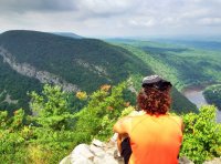
Not sure how hard this will be for you guys to get. I'll start without giving any clues.

image.jpeg
 
Is that the ridge/mountain across from Hawksbill Mountain, at Linville Gorge? (The rest of the surrounding area looks too low & rolling to be Linville Gorge area, I thought that area had more vertical relief around it. )

There are so many mountains that look just like that in NC/TN. Probably some in VA and a bit of SC too.
 
Nope, I'll give some clues.

- The most well known hiking path in the US goes over that mountain.

- The mountain in the picture is in one state, the mountain I took the picture from is in another, and the river in the "gap" between them is named after a third state.

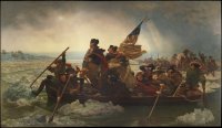
- I'll post another picture below where you can see the river to the right of my friend Copo. This is the same river that George Washington is crossing in the famous painting below (albeit he crossed it about 70 miles downstream of here).

image.jpeg

image.jpeg
 
Back
Top