Navigation
Install the app
How to install the app on iOS
Follow along with the video below to see how to install our site as a web app on your home screen.
Note: This feature may not be available in some browsers.
More options
Style variation
You are using an out of date browser. It may not display this or other websites correctly.
You should upgrade or use an alternative browser.
You should upgrade or use an alternative browser.
Guess the spot: Utah Edition
- Thread starter Ben
- Start date
John Morrow
Member
- Joined
- May 22, 2015
- Messages
- 1,119
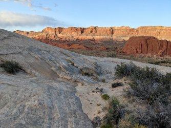
I got inside info so I have to pass, but I recognized that entrada blob right off! Beautiful pic and great light.
regehr
Member
- Joined
- Mar 28, 2012
- Messages
- 2,445
john we were sitting there barefoot, with generous portions of wild turkey 101. not sure if that appeals to you but this plus the light made me extremely happyI got inside info so I have to pass, but I recognized that entrada blob right off! Beautiful pic and great light.
Reef&Ruins
Colorado Plateau is calling...
- Joined
- Feb 3, 2017
- Messages
- 926
John Morrow
Member
- Joined
- May 22, 2015
- Messages
- 1,119
hint: photo is looking across a very long north-south oriented valley
sure is grand for some barefoot sunset relaxing
regehr
Member
- Joined
- Mar 28, 2012
- Messages
- 2,445
yes, hamburger rocks! you're upThis is a zone that very much interests me. Can you tell us a bit about your route?
we did a pretty easy and basic route... the friday before last we got started walking from the post corral around 5pm and camped way up near the top of the reef, which was easy since there were puddles everywhere since it had rained that day. we'd have gotten started much earlier but the Notom Bullfrog road had slicked up to the point where continuing was impossible so we had to wait for it to dry.
saturday we continued south, it was a short day and we explored a while, checking out a small rock art panel along the way. we walked up past all of the Muley Tanks and chilled at hamburger rocks for quite a while, then camped high up on the reef again.
sunday we walked about halfway up Lower Muley Twist and camped near a respectably perennial pool that I can send you data for if you like, but it had sorta nasty water, so again we drank from little potholes that were nice and cleanish. the pool was below a dryfall that we bypassed exploring to the east, but we stopped at the next dryfall and climbed around the rim for a while to catch the views.
monday we found that we had camped in essentially the very last place to catch the sun in the morning; we continued north to the cutoff trail to the post, it was only about 3.5 hours of walking, and then got back to SLC before dark.
all in all an extremely nice trip. but this is pretty much on the map now, we saw three other groups, though not while camping since we always camped somewhat out of the way. the alcoves along lower muley twist are the most amazing I've seen anywhere in Utah, just incredible.
Pukwudgie
Member
- Joined
- Jun 18, 2021
- Messages
- 197
Sounds delightful. I need to make it down there one of these days. Appreciate the write up, I'm always curious how people approach hiking the Fold.yes, hamburger rocks! you're up
we did a pretty easy and basic route... the friday before last we got started walking from the post corral around 5pm and camped way up near the top of the reef, which was easy since there were puddles everywhere since it had rained that day. we'd have gotten started much earlier but the Notom Bullfrog road had slicked up to the point where continuing was impossible so we had to wait for it to dry.
saturday we continued south, it was a short day and we explored a while, checking out a small rock art panel along the way. we walked up past all of the Muley Tanks and chilled at hamburger rocks for quite a while, then camped high up on the reef again.
sunday we walked about halfway up Lower Muley Twist and camped near a respectably perennial pool that I can send you data for if you like, but it had sorta nasty water, so again we drank from little potholes that were nice and cleanish. the pool was below a dryfall that we bypassed exploring to the east, but we stopped at the next dryfall and climbed around the rim for a while to catch the views.
monday we found that we had camped in essentially the very last place to catch the sun in the morning; we continued north to the cutoff trail to the post, it was only about 3.5 hours of walking, and then got back to SLC before dark.
all in all an extremely nice trip. but this is pretty much on the map now, we saw three other groups, though not while camping since we always camped somewhat out of the way. the alcoves along lower muley twist are the most amazing I've seen anywhere in Utah, just incredible.
zionsky
Member
- Joined
- Dec 23, 2018
- Messages
- 765
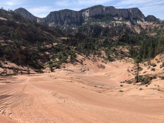
Greatheart mesa straight ahead with Rams peak poking out on the left sideIron Lion Zion!
John Morrow
Member
- Joined
- May 22, 2015
- Messages
- 1,119
Bravo! So apparently Zion but I couldn't nail it down. So is this Russell Gulch then?Greatheart mesa straight ahead with Rams peak poking out on the left side
Pukwudgie
Member
- Joined
- Jun 18, 2021
- Messages
- 197
Russell Gulch is off to the right not in photo. This is the approach for the Subway top down, and is a zone worth visiting in and of itself.Bravo! So apparently Zion but I couldn't nail it down. So is this Russell Gulch then?
Don't like ads? Become a BCP Supporting Member and kiss them all goodbye. Click here for more info.


