Guess the spot: Maps Edition

OK, I'm kickstarting the thread. Apologies @uintahiker - you can have your turn back if you wish.

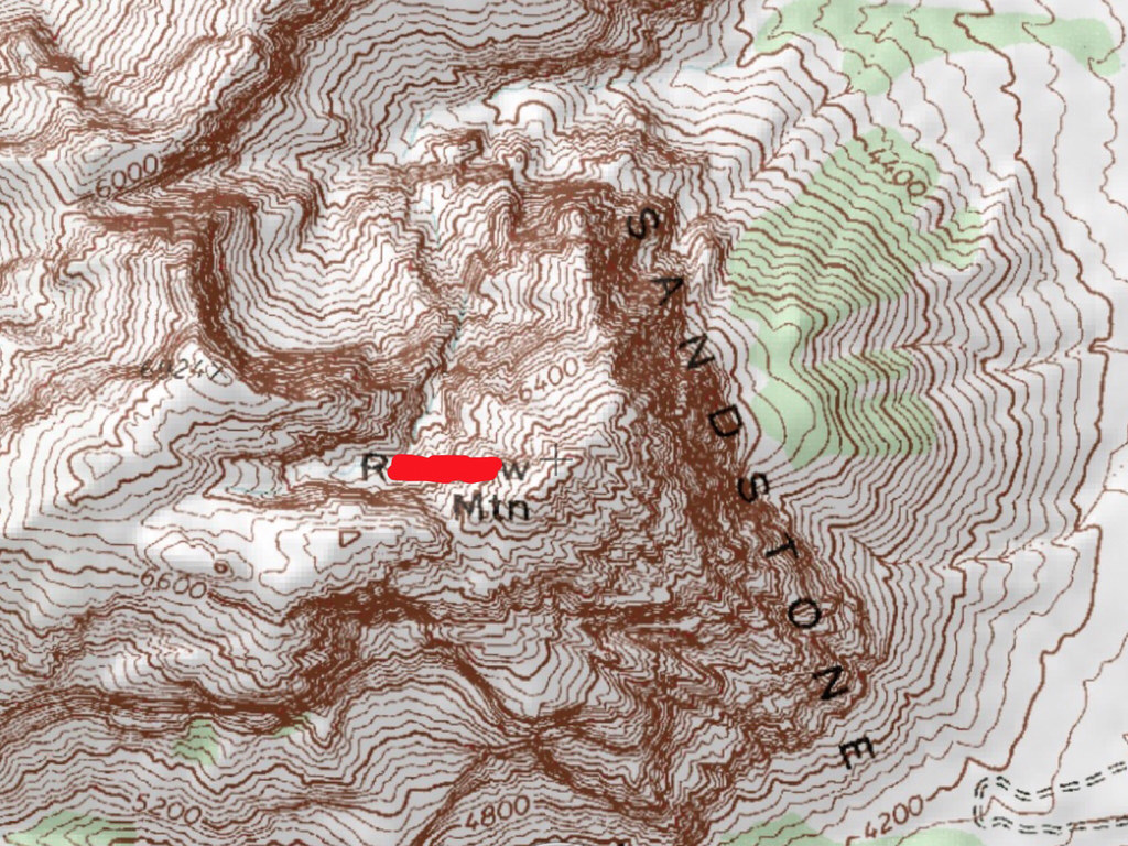
Planning a trip somewhere in Colorado next year. Name the drainage or one of the four marked peaks. Extra credit - name the "ridge" with the red checkmark - a famous rock climbing route, and my destination.
guessTheSpot.jpg
 

Attachments

  • guessTheSpot.jpg
    guessTheSpot.jpg
    122.1 KB · Views: 19
Looks like Wham Ridge on Vestal Peak. The others are Electric, Arrow and the Trinity group. The range is the Grenadiers between Durango and Silverton.
 
Looks like Wham Ridge on Vestal Peak. The others are Electric, Arrow and the Trinity group. The range is the Grenadiers between Durango and Silverton.
Well done. You are up. Have you climbed Wham Ridge?
 
Clue: nearby is an internationally famous 'cultural' destination
Dang. Good clue. Unusual to name the rock type on a topo, ~6000' so west of the Mississippi, precipitous terrain and a road on it. Should be easy.... No idea.
 
  • Like
Reactions: Bob
Okay, maybe 'cultural' is a stretch... But I thought calling it by it's proper name would be too easy: an internationally famous entertaiment destination.
 
Red Rocks, Colo ?
 
Red Rocks, Colo ?
Got it! You were close Bob. Well not that close. Two states away. But your statement caught my eye. The red'd out feature is Rainbow Mtn between Oak Creek and Pine Creek in Red Rock Canyon Natural Conservation Area just west of Las Vegas. A wonderful place to climb and hike and bird watch. In fact it is sorely underrepresented in trip reports here at BCP.

Kullaberg: cutlural headquarters? You must have been referring to Parump. :giggle:
 
ha ha ........ you owe me then.
Never been down there.....too hot
 
Langutah is up!

The hike to the summit of Rainbow Mountain is a classic desert expedition. The entire escarpment in fact, from the Calico Hills in the north all the way down to Windy Peak, is a fantastic place to explore. Most of the hiking is off-trail in boulder strewn canyons or exposed ledges. The 'peaks' are not easy to summit, as most require a full day and very complex routefinding.

Highly recommended for any desert aficianado.
 
Somewhere in Central Utah. Name the tower or the plateau in the northwest of the map.
Screen-Shot-2014-11-06-at-9.31.04-PM.jpg
 
It's Chimney Rock below Cedar Mountain. But that is really all I know of this feature.
You got it. It is the also the site of a controversial, newly-bulldozed ATV trail going up the mountain. You're up.
 
Similar threads
Thread starter Title Forum Replies Date
Outdoor_Fool The value of the various Guess the Spot threads General Discussion 6
wsp_scott NYTimes article: Guess the spot saves someone's life General Discussion 1
C Guess the Spot: somewhere in Southern Utah General Discussion 4
JDWalters Guess the Spot: Eastern US Edition General Discussion 515
LarryBoy Guess the Spot: Trip Reports Edition Hiking & Camping 5
balzaccom Guess the Spot--DIY version General Discussion 33
Ben Guess the spot: Utah Edition General Discussion 6324
Artemus Guess the Spot: International Edition General Discussion 283
Jammer Guess the Spot (not where you think) General Discussion 10
Backcountry Post Guess the spot General Discussion 7683
Perry Can You Guess Where The Uintas Are? General Discussion 5
J Identify the spot Utah: I don't know where it is General Discussion 2
Happyidiot Looking for camping spot close to Denver. General Discussion 2
Jammer Havasu Falls Extra Spot General Discussion 3
Nick Spot X Gear 27
SKLund Sticking with SPOT Gear 0
Ross Unofficial Where’s The Spot General Discussion 0
Perry Good Deal on a Spot Gen 3 Gear 5
Jammer Spot/InReach for May? Trip Planning 7
Bridgette Good camping spot in the Uintas with 4WD Trip Planning 0
jonmessina Spot Tracker Rental? Trip Planning 1
uintahiker The bloodiest spot in Arizona Hiking & Camping 0
Jammer InReach vs Spot Messenger 2013 Gear 32
wnorton Do you use Spot Connect or DeLorme InReach? Gear 6
Nurrgle Good car camping spot in the Uintas General Discussion 9
Nick SPOT Connect Gear 2
F Maps for the Bob Marshall Wilderness Resource Discussions 3
U Funny experience with Maps on iPad Everything Else 1
westy NW Wyoming Maps Trip Planning 13
T Findings while searching Google maps General Discussion 9
TrektheWorld Gazetteer Maps Gear 4
Mike Jones Who uses paper maps? General Discussion 42
Wanderlust073 Black Ridge Canyons Wilderness / Rattlesnake Canyon maps Trip Planning 6
Jackson Google Maps 3D Detail General Discussion 4
isleroyaleguy White Clouds maps? Trip Planning 4
Mike Jones Built a Custom Map Board for protecting my maps while hiking Gear 9
Bob Create Maps/Routes for Android Resource Discussions 1
Backcountry Post Embedding CalTopo Maps Questions, Suggestions & Support 23
andyjaggy Printing Maps General Discussion 13
Mike K Maps on your phone (cheap or free) General Discussion 25
Absarokanaut NOAA June, July, and August Seasonal Outlook Maps General Discussion 16
steve Google Maps Engine Question on windows 8.1 laptop with USB gps General Discussion 0
uintahiker Google Maps vs KML file embed General Discussion 2
Nick New Google Maps Engine SUCKS General Discussion 12
baltocharlie Maps for Spring trip Trip Planning 17
Waynee-ack Maps? General Discussion 4
Backcountry Post Embedding Maps Questions, Suggestions & Support 32
Nick Embedding Google Maps Questions, Suggestions & Support 0

Similar threads

Back
Top