DrNed
The mountains are calling and I must go
- Joined
- Mar 31, 2013
- Messages
- 1,026
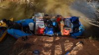
After months of working out all the small details, interviewing everyone I could and scouring the trip report here on BCP, me, my friend Aaron and five boys set out to do 68 miles down the Green River from June 16-20. The two adults and one of the boys would operate the raft with all the gear and the four other boys would each float in a self made, skin on frame kayak. Mine's the one with the blue stripes.It's this very kayak that I had my scariest backcountry experience in.

A few items to discuss before continuing: 1) Most people Ive talked to encouraged me to start at Ruby Ranch and if you' want to get all the good stuff in a condensed trip then that's good advice. To me, any day on a river is a good day, regardless. Also, I liked starting at Green River State Park because we had the time and that gave us two days to anticipate the beauties to come.
2) There was a late run off due to some late snow and being early in the season water levels were high. About 17k cfs on the day we started. Along with that on Monday the 16th & Tuesday the 17th there were very strong winds. According to the weather service they got up to 35 mph on Tuesday. **WARNING**On this river, independent of each other, wind and water levels probably wouldn't make any difference. Combined they will create what I will call in my amateur rating class II rapids. More to come on this . . .
So, as is always the case, we got on the river a little later than desired.
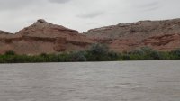
Here's some images a little ways down the river

Crystal Geyser

With mild to moderate winds and not really knowing what to expect as far as camp spots on this stretch we pulled out at a place called Little Valley. About 7 miles down river from the start.
This is my favorite shot of that camp spot. I like how the muted evening light makes the scenery look almost black & white combined with the bright yellow of the kayaks.

It was Monday night at this camp spot that we would see the only other people on the river all week, when a few canoes passed at about 7:30 PM.
Should you do this stretch of the river, I highly recommend this area for camping. Flat, trees, soft sand for tents and some little hills to explore should you like that kind of thing.

Tuesday morning we arose to clear sunny skies and optimism for things to come . . .My son wanted to experience driving the raft so on Tuesday he and I switched. Which means I didn't have my camera with me to take photos so you'll have to use your imagination here. I did get these next two with my phone in it's LifeProof case.

We were on the river around 9:00 AM to similar winds we experienced the day before. It's probably due to being in a kayak, but the river felt like it was moving much quicker on Tuesday. The kayaks were flying. The raft with people, frame & all the gear was weighing in at about 1,000 pounds I'm guessing. So it wasn't moving so fast. So those in the kayaks would get ahead and wait for the raft to catch up.

That mud really made a difference because I was getting fried!
Throughout Tuesday morning we encounter some bouncy water and strong winds, but just enough to make it exciting for those of us in the kayaks. It was after lunch that things got . . . stressful.
In certain places I would rate the water as class II rapids based on the height of the waves and the eddys that were created. The kicker was the dirt being blown. So we've got white caps, wind at 35 mph in our faces and in one place there was a cliff where we got dirt blown off the top into our faces.
One thing that helped these kayaks was we carried our water in jugs in the open space in the front and back, making them much more stable. I really think that it made a big difference in keeping us in the boat through the rough water.
At about 5:00 on Tuesday evening totally beat physically & mentally we pulled off at Salt Wash. We ended up going 18 miles.
You'll recognize Salt Wash by this cool tree & rock.
 This is looking up river.
So just after this rock & tree there's an inlet. We paddled up 20-30 yards and came to this landing.

I would give high marks to this camp spot too because it's flat, secluded, and has close access via the inlet.
After setting up camp Tuesday night, we had dinner - pizzas cooked in a frying pan - and went to bed. It felt SO GOOD to get out of the wind. Here's what it was like at camp. Remember this is in a cove so much of the wind was blocked.


Then about 2:00 AM the wind stopped . . . until about 6:30 AM.
Tuesday morning we got and everything in our tents is covered with a layer of sand. Here we are shaking some of it out.

Here's a shot looking up Salt Wash.

It was Wednesday morning when the wind picked up again that I started questioning. I just didn't think we could do another day like Tuesday. The fatigue was obvious Wednesday morning as we were all moving kinda slow.
Packing up camp at Salt Wash

The good thing was once we got on the river the wind slowly faded throughout the morning and wouldn't be an issue the rest of the trip.
Wednesday ended up being a short day on the river. We camped Wednesday at 10 Mile Canyon. Again accessed via an inlet.

This ended up being an A+ camp site as well for all the reasons previously mentioned. It may be worth pointing out that if we had competition on the river, finding spots would have been difficult at this water level.
Cool tree at 10 Mile Canyon campsite.

Looking up 10 Mile Canyon

Cool cloud shot at 10 Mile Canyon

Being a short day on the river we spent quite a bit of the afternoon exploring and goofing off. I was able to wash up and take a nap in my hammock. I love napping in the wild.
We tended to be on the river between 9:30 & 10:00 each morning and Thursday was no exception. This the day I had been looking forward to the most because of our stops at registry rock, bow knot bend etc.
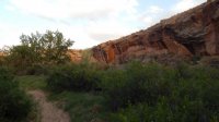
Here's a couple random shots between 10 Mile & Registry Rock


Not sure, but I think this is Hell Roaring Canyon

I don't know if it's always like this, but the mud was absolutely terrible everyplace we pulled out. When I would step out of the boat I would go up to my knee in what I can only call quicksand like mud. Well when we pulled off at Registry Rock the mud was hungry for my water shoes so it kept them.
So I hiked up to Registry Rock barefoot! Did get some good shots, making it worth while.


My only disappointment of this entire trip was we didn't get up bow knot. Once we were in range we looked all along the shore for a pull out spot for the raft . . . but no luck.
Here's bow knot from the backside.

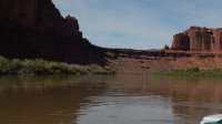
More random shots along the river from Thursday.


We were hoping to camp at Spring Canyon Thursday, but again there wasn't anyplace with enough room to land the raft. So we kept going.
Abandoned mining equipment along canyon wall.

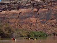
I love these shots for the contrast the small kayakers give the tall canyon walls.


We saw a fair amount of wild life. Lizards, a deer, a beaver, and several of these blue herons.

We ended up putting in 20 miles on Thursday, finally stopping at Two Mile Canyon. As the others accessed via an inlet.
Shots from around 2 Mile Canyon camp spot


This is up 2 Mile 100 yards or so and looking down canyon.

Up canyon


Having put in 20 miles on Thursday we were ahead of schedule, so we slept in Friday morning, took our time with breakfast and knocked around the surrounding cliffs.
From 2 Mile Canyon we only had 8 miles to Mineral Bottom - the pull out spot. Having the raft we ate pretty well all week. We perfected the "eating on the go" for lunch. Another thing we did that ended up being a good choice was one cooler of water and one cooler of Gatorade, with the spigot facing out, allowing the kayakers to paddle up next to the raft and fill their bottle on the go.

Shots along the river on Friday.


Finally reaching the end, 68 miles later.


All and all this was a great trip! As with all trips it had it's challenges and it's pay offs. I think one could do this trip several times and not see all there is to see.
The pros to doing this in high water was the speed we traveled. By my estimation the kayaks could do 7+ mph. The top speed for the raft was 3.5 mph. The cons would be limited camps spots . . . and the mud!
Featured image for home page:

A few items to discuss before continuing: 1) Most people Ive talked to encouraged me to start at Ruby Ranch and if you' want to get all the good stuff in a condensed trip then that's good advice. To me, any day on a river is a good day, regardless. Also, I liked starting at Green River State Park because we had the time and that gave us two days to anticipate the beauties to come.
2) There was a late run off due to some late snow and being early in the season water levels were high. About 17k cfs on the day we started. Along with that on Monday the 16th & Tuesday the 17th there were very strong winds. According to the weather service they got up to 35 mph on Tuesday. **WARNING**On this river, independent of each other, wind and water levels probably wouldn't make any difference. Combined they will create what I will call in my amateur rating class II rapids. More to come on this . . .
So, as is always the case, we got on the river a little later than desired.
Here's some images a little ways down the river
Crystal Geyser
With mild to moderate winds and not really knowing what to expect as far as camp spots on this stretch we pulled out at a place called Little Valley. About 7 miles down river from the start.
This is my favorite shot of that camp spot. I like how the muted evening light makes the scenery look almost black & white combined with the bright yellow of the kayaks.
It was Monday night at this camp spot that we would see the only other people on the river all week, when a few canoes passed at about 7:30 PM.
Should you do this stretch of the river, I highly recommend this area for camping. Flat, trees, soft sand for tents and some little hills to explore should you like that kind of thing.
Tuesday morning we arose to clear sunny skies and optimism for things to come . . .My son wanted to experience driving the raft so on Tuesday he and I switched. Which means I didn't have my camera with me to take photos so you'll have to use your imagination here. I did get these next two with my phone in it's LifeProof case.
We were on the river around 9:00 AM to similar winds we experienced the day before. It's probably due to being in a kayak, but the river felt like it was moving much quicker on Tuesday. The kayaks were flying. The raft with people, frame & all the gear was weighing in at about 1,000 pounds I'm guessing. So it wasn't moving so fast. So those in the kayaks would get ahead and wait for the raft to catch up.
That mud really made a difference because I was getting fried!
Throughout Tuesday morning we encounter some bouncy water and strong winds, but just enough to make it exciting for those of us in the kayaks. It was after lunch that things got . . . stressful.
In certain places I would rate the water as class II rapids based on the height of the waves and the eddys that were created. The kicker was the dirt being blown. So we've got white caps, wind at 35 mph in our faces and in one place there was a cliff where we got dirt blown off the top into our faces.
One thing that helped these kayaks was we carried our water in jugs in the open space in the front and back, making them much more stable. I really think that it made a big difference in keeping us in the boat through the rough water.
At about 5:00 on Tuesday evening totally beat physically & mentally we pulled off at Salt Wash. We ended up going 18 miles.
You'll recognize Salt Wash by this cool tree & rock.
This is looking up river.So just after this rock & tree there's an inlet. We paddled up 20-30 yards and came to this landing.
I would give high marks to this camp spot too because it's flat, secluded, and has close access via the inlet.
After setting up camp Tuesday night, we had dinner - pizzas cooked in a frying pan - and went to bed. It felt SO GOOD to get out of the wind. Here's what it was like at camp. Remember this is in a cove so much of the wind was blocked.
Then about 2:00 AM the wind stopped . . . until about 6:30 AM.
Tuesday morning we got and everything in our tents is covered with a layer of sand. Here we are shaking some of it out.
Here's a shot looking up Salt Wash.
It was Wednesday morning when the wind picked up again that I started questioning. I just didn't think we could do another day like Tuesday. The fatigue was obvious Wednesday morning as we were all moving kinda slow.
Packing up camp at Salt Wash
The good thing was once we got on the river the wind slowly faded throughout the morning and wouldn't be an issue the rest of the trip.
Wednesday ended up being a short day on the river. We camped Wednesday at 10 Mile Canyon. Again accessed via an inlet.
This ended up being an A+ camp site as well for all the reasons previously mentioned. It may be worth pointing out that if we had competition on the river, finding spots would have been difficult at this water level.
Cool tree at 10 Mile Canyon campsite.
Looking up 10 Mile Canyon
Cool cloud shot at 10 Mile Canyon
Being a short day on the river we spent quite a bit of the afternoon exploring and goofing off. I was able to wash up and take a nap in my hammock. I love napping in the wild.
We tended to be on the river between 9:30 & 10:00 each morning and Thursday was no exception. This the day I had been looking forward to the most because of our stops at registry rock, bow knot bend etc.
Here's a couple random shots between 10 Mile & Registry Rock
Not sure, but I think this is Hell Roaring Canyon
I don't know if it's always like this, but the mud was absolutely terrible everyplace we pulled out. When I would step out of the boat I would go up to my knee in what I can only call quicksand like mud. Well when we pulled off at Registry Rock the mud was hungry for my water shoes so it kept them.
So I hiked up to Registry Rock barefoot! Did get some good shots, making it worth while.
My only disappointment of this entire trip was we didn't get up bow knot. Once we were in range we looked all along the shore for a pull out spot for the raft . . . but no luck.
Here's bow knot from the backside.
More random shots along the river from Thursday.
We were hoping to camp at Spring Canyon Thursday, but again there wasn't anyplace with enough room to land the raft. So we kept going.
Abandoned mining equipment along canyon wall.
I love these shots for the contrast the small kayakers give the tall canyon walls.
We saw a fair amount of wild life. Lizards, a deer, a beaver, and several of these blue herons.
We ended up putting in 20 miles on Thursday, finally stopping at Two Mile Canyon. As the others accessed via an inlet.
Shots from around 2 Mile Canyon camp spot
This is up 2 Mile 100 yards or so and looking down canyon.
Up canyon
Having put in 20 miles on Thursday we were ahead of schedule, so we slept in Friday morning, took our time with breakfast and knocked around the surrounding cliffs.
From 2 Mile Canyon we only had 8 miles to Mineral Bottom - the pull out spot. Having the raft we ate pretty well all week. We perfected the "eating on the go" for lunch. Another thing we did that ended up being a good choice was one cooler of water and one cooler of Gatorade, with the spigot facing out, allowing the kayakers to paddle up next to the raft and fill their bottle on the go.
Shots along the river on Friday.
Finally reaching the end, 68 miles later.
All and all this was a great trip! As with all trips it had it's challenges and it's pay offs. I think one could do this trip several times and not see all there is to see.
The pros to doing this in high water was the speed we traveled. By my estimation the kayaks could do 7+ mph. The top speed for the raft was 3.5 mph. The cons would be limited camps spots . . . and the mud!
Featured image for home page:
Attachments
Last edited by a moderator: