Dustynails0
Member
- Joined
- Feb 10, 2021
- Messages
- 5
Hello, my name is Dustin. I have been planning and dreaming about a trip from Beartooth Lake to east rosebud for about ten years now and have got a lot of inspiration from this site though I just now created an account! I am getting more serious about planning my trip for this summer and have a route planned from Beartooth lake to Martin/Wright lake then up to Flat Rock and on to Snowbank Lakes then over the mountain to the other MArin lake and on to meet up with the beaten path. I know many of you have done stretches of this route at different times. I was wondering any challenges of route picking as you get closer to the big mountains and any other input.
I have backpacked the southern portion of the plateau many times, though it has been a while. I have done plenty of other beartooth backpacking trips mostly over by Red Lodge (Silver Run area, Lake Fork, TImberline lake, quinenbau meadows) So i am familiar with the challenges. However, this is a bigger undertaking so I am wanting to make sure my goals are realistic. I am pretty confident in the first 1.5-2 days because I am more comfortable with that area. It is just crossing the beartooth wall that I am trying to get figured out. I am thinking 4-5 days in mid july, hoping snow would help with the big passes. Is that a good time or earlier/later? Most of august is out for me due to fire season.
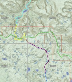
On the map I attached the different colored lines are different days of the trip.

Thanks for any help that you have and thanks for all the great reports! I promise to post mine whenever I actually get to do it!
I have backpacked the southern portion of the plateau many times, though it has been a while. I have done plenty of other beartooth backpacking trips mostly over by Red Lodge (Silver Run area, Lake Fork, TImberline lake, quinenbau meadows) So i am familiar with the challenges. However, this is a bigger undertaking so I am wanting to make sure my goals are realistic. I am pretty confident in the first 1.5-2 days because I am more comfortable with that area. It is just crossing the beartooth wall that I am trying to get figured out. I am thinking 4-5 days in mid july, hoping snow would help with the big passes. Is that a good time or earlier/later? Most of august is out for me due to fire season.
On the map I attached the different colored lines are different days of the trip.

Thanks for any help that you have and thanks for all the great reports! I promise to post mine whenever I actually get to do it!
