Born to Hike
Member
- Joined
- Jan 14, 2017
- Messages
- 146
I love the Winds, but hate the swarming blood-sucking bugs. I decided to do a loop, opposite direction, that I took 8 years ago with some friends of mine, but this time later in the summer (mid August) to hopefully miss the peak bug season. Success! It was a hot dry year this year (2018) and no bugs. Smoky, though - I guess that was the trade off.
The basic Itinerary:
Day 1: From Big Sandy Trail head hiked North to Skull Lake (10 miles).
Day 2: East to Washakie Pass, continue towards Ranger Park, then South to South Fork Lakes (7 miles).
Day 3: East off-trail up to Lizard Head Plateau, explored around on Lizard Head Trail, then South to Bear Lake (6 miles).
Day 4: West to the Cirque of The Towers, South over Jackass Pass to Big Sandy Lake, then back to the Big Sandy Trail Head (13 miles).
Just me and the dogs. I prefer not going solo, but I had the time and was healthy so off I went..

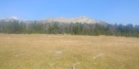
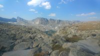
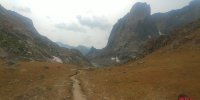
Heading North on the Fremont Trail towards Dad's Lake, a gentle uphill climb through open meadows with peaks to the right (East)..

and a spectacular Cirque of Peaks straight ahead (North).
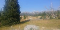
 more peaks to the right (East). Sorry that I didn't take the time with all of the peak names, just enjoying the reverie..

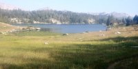
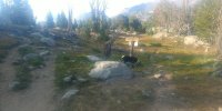
Around mile 4 was the the first lake: Mirror Lake

Then Mount Geikie of the unnamed cirque showing itself again..

Dad's Lake was next. What a beautiful Lake! I loved the perspective of hiking North in the late afternoon hours with the sun setting on my left as I headed North.
Passing the North end of Dad's a very large Bald Eagle flew low over my head, checking ME out. I wasn't fast enough with my smartphone to capture that except for a poor video showing it as a small speck as it continued on..it was an awesome scene though..
Even with it being a very hot and dry and late into the summer, there were areas of green with a few wildflowers, AND NO BUGS.
Very nice.
Next lake was Marms Lake, about 6.5 miles in so far. I saw few campers here as I traveled on.
The junction for Washaikie Pass, Shadow Lake, and Skull Lake was on the North Side of Marms Lake. This photo is looking South at Marms: to the upper left you can see a few peaks on the backside of the Cirque of the Towers.

Soon I was again very much enjoying the views ahead of me, and I couldn't stop taking photos of the views, so here are a few more to enjoy..


A spectacular cirque of granite peaks, to view during 3 hours of hiking that 1st day. If this cirque does not have a name, it should.

The last 45 minutes or so I could see Washakie Pass that I would be hiking over the next day.

Finally Skull Lake. The weather was PERFECT, but warm. I went through 3 Liters of water in just over 4 hours of hiking.

So I dropped my pack and into the Lake I went with clothes and all to rinse them and myself off.
Without being Mr Voyeur (I kept my shorts on) I let my clothing dry while I dried off in the sun and enjoyed an awesome sunset. It doesn't take long to dry off in that thin dry air, especially during such a nice evening.

For those who would rather see the sunset over Skull Lake without me in it..")

A poor attempt with my smartphone to capture the moon after the sun went down.

Day #2.
The next morning by chance I crossed paths with a Youtuber, aka "Fikeandhish", who my wife and I met him while Backpacking in the Uintas 2 months earlier. He was finishing a 9 day through hike in the Winds with his son. Small world!

Starting the climb up towards Washakie Pass looking Southward. It was a VERY smoky day - California in the air in all the wrong ways. Through the haze you can see more Peaks from the backside of The Cirque of The Towers.

My dogs happily finding snow on Washikie Pass. The climb up the pass from the West was not bad, better than the climb from the East going the opposite direction 8 years ago. Maybe I was in better shape this time around..

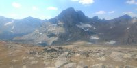
Descending the small glacier looking towards Ranger Park and Buffalo Head Peak. Even with all the haze the views were worth the effort.
Another large Bald Eagle was soaring high above this basin - probably the same one that I saw the day before at Dad's lake.

Finished my successful "glissade", and happy about it.

A few more late summer wildflowers..

Buffalo Head. To stay at elevation by not dropping down to Ranger Park and then back up again, I chose to skirt around this peak off trail towards South Fork Lakes.

Looking back towards Washakie Pass and Little Washakie Lake as I was on my way off trail towards South Fork Lakes.

A massive boulder cleft in two that I would have loved to take home and put in my yard. Just not enough space in my pack though..lol..

Drainage out of South Fork Lakes

Very stellar-looking peaks around Buffalo Head

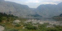
My first view and first visit to South Fork Lakes. This basin rocks (no pun intended!).

A massive glacier below Camels Hump Peak, and..

A water fall coming off of Lizard Head Plateau!
I really loved this basin and would have spent a few days here if I had more time on this trip.


Enjoying the view of Buffalo Head from my camp while the sun set.

From this perspective Buffalo Head should be named "Elephant Head". Can you see it?

Day #3
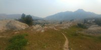
The smoke had cleared out a bit, no clouds and perfect weather. The massive monolith peaks are amazing in these mountains.

One last view of the waterfall before ascending off-trail to Lizard Head Plateau.
It was a tough climb, but enjoyed every bit of catching my breath and taking in the views behind me. Looking back at South Fork Lakes Basin.

Another shot with the front camera on my phone. Not sure why the photo is reversed, but still an awesome photo!

This is the off-trail, very steep route that I and the dogs scrambled up. It was one of those take 25 steps, then stop and catch your breath climbs - very steep - especially carrying your backpack at over 11,000 feet!
I was a bit concerned how it would go and if it was really a good idea, but it worked out well.

Avoiding boulder hopping I stayed to the left and halfway up was on grassy/peat moss-type-turf. I month earlier I'm sure this was all still covered in snow/glacier.

What is left of the glacier this time of year..

That scamble up took over an hour, but finally we (the dogs and I) made it on top of Lizard Head Plateau and the trail.


I headed North on Lizard to find the source of the water fall dropping into South Fork Lakes. This Plateau is over 11,500 feet in elevation with not much for a water source, but after about a mile of exploring North I found the stream, and followed it to where it cascaded into the Basin.
The waterfall begins behind me. South Fork Lakes in the background.

I love this Plateau - it is like moonscape. A definite must-see to experience. Pictures just does not do justice of being there.

I spent a couple of hours on Lizard Head just taking my time, enjoying the near perfect weather (very little to no wind on that day) and soaking it all in as best I could.


Eventually I made my way further South and began descending down towards Lizard Head Meadows. The Monolith was quick to show itself.

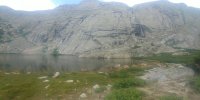
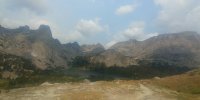
Lower and upper Bear Lakes at the base of Lizard Head Peak, with The Cirque of the Towers to the left. It was still early in the afternoon, but decided to stop and camp at the upper Bear Lake and avoid the crowds in the Meadow and the Cirque area.

Another view of The Monolith as I continued the descent towards Bear Lakes and Lizard Head Meadows.

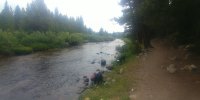
Well the sun was still out, I was alone and sweaty and dirty again with extra time to burn. The stream (behind me) coming out of upper Bear Lake looked and was VERY COLD, but good to wash clothes and body off again.

Just chillin after washin' Again NO BUGS to speak of.

Watching the sun drop behind Lizard Head Peak.

The view of The Monolith looking opposite of Lizard Head Peak. Not a bad place to camp for the night eh?

Day #4
It rained hard that night for a good 3 hours. The next day the air was clear and cool and full of moisture - perfect for a 13 + mile "walk" back to the car.
This was the view in front of me after descending down from Bear Lakes into Lizard Head Meadow, heading West into the Cirque then veering left up to Jackass Pass. Another spectacular view in front of me to enjoy!
And this is where the people where..lots of them. During the next 2 miles I passed 50 + hikers/campers. Some camping right on the trail. It was Saturday/the weekend.

A shot of wildflowers beginning the climb towards Jackass Pass. Amazing for mid August.

There are thousands of photos of the "WatchTower" in the Cirque, so no harm posting another one, right?

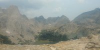
Looking back at The Watch Tower and Lonesome Lake in the Cirque and towards Texas Pass. My 4 day, 36 mile trip was basically a clockwise loop around and through The Cirque.

A better view of Texas Pass (where the bit of snow is just right-center of the photo), looking North as I was close to the top of Jackass Pass.

The climb up to Jackass from The Cirque was fairly quick.

The next Lake was Arrowhead Lake -a fitting name. Granite peaks and boulder fields everywhere. It looked and felt like rain, but it never came till I was driving away from the trail head.

A few pics of North Lake on the way down to Big Sandy Lake.


Another cirque of granite peaks towering above Big Sandy Lake to the South. The trail from this point was in good shape and easy.


I stopped for a lunch break at Big Sandy to refuel and rest a bit for the final 6 + miles. Then boogied back to the car. The smoke was still hanging around this basin.

I would have fly fished along the Big Sandy River - had I brought my fly rod - and had more time, but was "smelling the barn" at this point and hiking as fast as a fast walk would carry me.

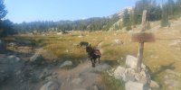
The point of coming full circle: Four days earlier I turned left at this junction towards Dad's Lake. Now looking back on the trail right, coming from Big Sandy Lake.

Hello humanity! A very packed parking lot, and my ride home.

After a five hour drive home I dropped my pack and left it for for a few days (minus the dirty clothes) to remind me of the wonderful trip I just experienced, solo in the Windrivers.

The basic Itinerary:
Day 1: From Big Sandy Trail head hiked North to Skull Lake (10 miles).
Day 2: East to Washakie Pass, continue towards Ranger Park, then South to South Fork Lakes (7 miles).
Day 3: East off-trail up to Lizard Head Plateau, explored around on Lizard Head Trail, then South to Bear Lake (6 miles).
Day 4: West to the Cirque of The Towers, South over Jackass Pass to Big Sandy Lake, then back to the Big Sandy Trail Head (13 miles).
Just me and the dogs. I prefer not going solo, but I had the time and was healthy so off I went..
Heading North on the Fremont Trail towards Dad's Lake, a gentle uphill climb through open meadows with peaks to the right (East)..
and a spectacular Cirque of Peaks straight ahead (North).
more peaks to the right (East). Sorry that I didn't take the time with all of the peak names, just enjoying the reverie..Around mile 4 was the the first lake: Mirror Lake
Then Mount Geikie of the unnamed cirque showing itself again..
Dad's Lake was next. What a beautiful Lake! I loved the perspective of hiking North in the late afternoon hours with the sun setting on my left as I headed North.
Passing the North end of Dad's a very large Bald Eagle flew low over my head, checking ME out. I wasn't fast enough with my smartphone to capture that except for a poor video showing it as a small speck as it continued on..it was an awesome scene though..
Even with it being a very hot and dry and late into the summer, there were areas of green with a few wildflowers, AND NO BUGS.
Very nice.
Next lake was Marms Lake, about 6.5 miles in so far. I saw few campers here as I traveled on.
The junction for Washaikie Pass, Shadow Lake, and Skull Lake was on the North Side of Marms Lake. This photo is looking South at Marms: to the upper left you can see a few peaks on the backside of the Cirque of the Towers.
Soon I was again very much enjoying the views ahead of me, and I couldn't stop taking photos of the views, so here are a few more to enjoy..
A spectacular cirque of granite peaks, to view during 3 hours of hiking that 1st day. If this cirque does not have a name, it should.
The last 45 minutes or so I could see Washakie Pass that I would be hiking over the next day.
Finally Skull Lake. The weather was PERFECT, but warm. I went through 3 Liters of water in just over 4 hours of hiking.
So I dropped my pack and into the Lake I went with clothes and all to rinse them and myself off.
Without being Mr Voyeur (I kept my shorts on) I let my clothing dry while I dried off in the sun and enjoyed an awesome sunset. It doesn't take long to dry off in that thin dry air, especially during such a nice evening.
For those who would rather see the sunset over Skull Lake without me in it..
A poor attempt with my smartphone to capture the moon after the sun went down.
Day #2.
The next morning by chance I crossed paths with a Youtuber, aka "Fikeandhish", who my wife and I met him while Backpacking in the Uintas 2 months earlier. He was finishing a 9 day through hike in the Winds with his son. Small world!
Starting the climb up towards Washakie Pass looking Southward. It was a VERY smoky day - California in the air in all the wrong ways. Through the haze you can see more Peaks from the backside of The Cirque of The Towers.
My dogs happily finding snow on Washikie Pass. The climb up the pass from the West was not bad, better than the climb from the East going the opposite direction 8 years ago. Maybe I was in better shape this time around..
Descending the small glacier looking towards Ranger Park and Buffalo Head Peak. Even with all the haze the views were worth the effort.
Another large Bald Eagle was soaring high above this basin - probably the same one that I saw the day before at Dad's lake.
Finished my successful "glissade", and happy about it.
A few more late summer wildflowers..
Buffalo Head. To stay at elevation by not dropping down to Ranger Park and then back up again, I chose to skirt around this peak off trail towards South Fork Lakes.
Looking back towards Washakie Pass and Little Washakie Lake as I was on my way off trail towards South Fork Lakes.
A massive boulder cleft in two that I would have loved to take home and put in my yard. Just not enough space in my pack though..lol..
Drainage out of South Fork Lakes
Very stellar-looking peaks around Buffalo Head
My first view and first visit to South Fork Lakes. This basin rocks (no pun intended!).
A massive glacier below Camels Hump Peak, and..
A water fall coming off of Lizard Head Plateau!
I really loved this basin and would have spent a few days here if I had more time on this trip.
Enjoying the view of Buffalo Head from my camp while the sun set.
From this perspective Buffalo Head should be named "Elephant Head". Can you see it?
Day #3
The smoke had cleared out a bit, no clouds and perfect weather. The massive monolith peaks are amazing in these mountains.
One last view of the waterfall before ascending off-trail to Lizard Head Plateau.
It was a tough climb, but enjoyed every bit of catching my breath and taking in the views behind me. Looking back at South Fork Lakes Basin.
Another shot with the front camera on my phone. Not sure why the photo is reversed, but still an awesome photo!
This is the off-trail, very steep route that I and the dogs scrambled up. It was one of those take 25 steps, then stop and catch your breath climbs - very steep - especially carrying your backpack at over 11,000 feet!
I was a bit concerned how it would go and if it was really a good idea, but it worked out well.
Avoiding boulder hopping I stayed to the left and halfway up was on grassy/peat moss-type-turf. I month earlier I'm sure this was all still covered in snow/glacier.
What is left of the glacier this time of year..
That scamble up took over an hour, but finally we (the dogs and I) made it on top of Lizard Head Plateau and the trail.
I headed North on Lizard to find the source of the water fall dropping into South Fork Lakes. This Plateau is over 11,500 feet in elevation with not much for a water source, but after about a mile of exploring North I found the stream, and followed it to where it cascaded into the Basin.
The waterfall begins behind me. South Fork Lakes in the background.
I love this Plateau - it is like moonscape. A definite must-see to experience. Pictures just does not do justice of being there.
I spent a couple of hours on Lizard Head just taking my time, enjoying the near perfect weather (very little to no wind on that day) and soaking it all in as best I could.
Eventually I made my way further South and began descending down towards Lizard Head Meadows. The Monolith was quick to show itself.
Lower and upper Bear Lakes at the base of Lizard Head Peak, with The Cirque of the Towers to the left. It was still early in the afternoon, but decided to stop and camp at the upper Bear Lake and avoid the crowds in the Meadow and the Cirque area.
Another view of The Monolith as I continued the descent towards Bear Lakes and Lizard Head Meadows.
Well the sun was still out, I was alone and sweaty and dirty again with extra time to burn. The stream (behind me) coming out of upper Bear Lake looked and was VERY COLD, but good to wash clothes and body off again.
Just chillin after washin'
Again NO BUGS to speak of. Watching the sun drop behind Lizard Head Peak.
The view of The Monolith looking opposite of Lizard Head Peak. Not a bad place to camp for the night eh?
Day #4
It rained hard that night for a good 3 hours. The next day the air was clear and cool and full of moisture - perfect for a 13 + mile "walk" back to the car.
This was the view in front of me after descending down from Bear Lakes into Lizard Head Meadow, heading West into the Cirque then veering left up to Jackass Pass. Another spectacular view in front of me to enjoy!
And this is where the people where..lots of them. During the next 2 miles I passed 50 + hikers/campers. Some camping right on the trail. It was Saturday/the weekend.
A shot of wildflowers beginning the climb towards Jackass Pass. Amazing for mid August.
There are thousands of photos of the "WatchTower" in the Cirque, so no harm posting another one, right?
Looking back at The Watch Tower and Lonesome Lake in the Cirque and towards Texas Pass. My 4 day, 36 mile trip was basically a clockwise loop around and through The Cirque.
A better view of Texas Pass (where the bit of snow is just right-center of the photo), looking North as I was close to the top of Jackass Pass.
The climb up to Jackass from The Cirque was fairly quick.
The next Lake was Arrowhead Lake -a fitting name. Granite peaks and boulder fields everywhere. It looked and felt like rain, but it never came till I was driving away from the trail head.
A few pics of North Lake on the way down to Big Sandy Lake.
Another cirque of granite peaks towering above Big Sandy Lake to the South. The trail from this point was in good shape and easy.
I stopped for a lunch break at Big Sandy to refuel and rest a bit for the final 6 + miles. Then boogied back to the car. The smoke was still hanging around this basin.
I would have fly fished along the Big Sandy River - had I brought my fly rod - and had more time, but was "smelling the barn" at this point and hiking as fast as a fast walk would carry me.
The point of coming full circle: Four days earlier I turned left at this junction towards Dad's Lake. Now looking back on the trail right, coming from Big Sandy Lake.
Hello humanity! A very packed parking lot, and my ride home.
After a five hour drive home I dropped my pack and left it for for a few days (minus the dirty clothes) to remind me of the wonderful trip I just experienced, solo in the Windrivers.
Attachments
-
 0815181546c.jpg199.5 KB · Views: 31
 -
 0815181600.jpg253 KB · Views: 29
 -
 0815181712_HDR.jpg248.4 KB · Views: 28
 -
 0815181713.jpg253.2 KB · Views: 28
 -
 0815181818.jpg262.7 KB · Views: 29
 -
 0816181134a.jpg170.7 KB · Views: 29
 -
 0816181638.jpg236.2 KB · Views: 29
 -
 0816181652.jpg230.2 KB · Views: 29
 -
 0817181243a.jpg292.5 KB · Views: 30
 -
 0817181333.jpg223.4 KB · Views: 28
 -
 0818181204c.jpg164.1 KB · Views: 28
 -
 0818181214.jpg210.2 KB · Views: 28
 -
 0818181216.jpg180.1 KB · Views: 28
 -
 0818181552a.jpg182 KB · Views: 34
