HomerJ
Member
- Joined
- Jan 19, 2012
- Messages
- 1,199
PROLOGUE:
Titcomb Basin has been on my "to see" list for a pretty much ever since I started backpacking. So when my buddy called me up and said he's going into Titcomb this year I jumped at the chance! We set it up for Wednesday through Sunday. As things got closer people started to drop out and it was soon down to 5 (about the right number IMHO) going. Then I was faced with a very tough decision of having to drop out myself! My sister had moved her wedding date up a week to the weekend we'd be in Titcomb! Everyone, including her, was telling me to go because I had this planned for nearly 6 months. Well, the more I thought about it the more guilty I knew I would feel while up in there in the wilderness. So I decided that I would hike out solo on Friday to make the wedding Saturday. At first my family was against this as they didn't think it was wise to hike alone. But I informed them that it was one of the busiest trails in the Winds, it was a Friday and there would be lots of people hiking in (turned out there wasn't as much as when we went in), and I had my cell phone and 30 mile radio with me. This convinced them and I was still in!!!!
About 4 days before the trip, one of the guys had to bail. So it was down to 4 of us. My buddy and I would be driving from Cache Valley and meeting the two others from SLC in Pinedale. I would head out Friday alone and the guys from SLC and my buddy would head out Saturday as the two from SLC had to be home Saturday.
DAY 1:
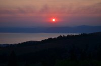
I left my house about 5:30am Wednesday and drove over and picked up my friend. We made it to the summit above Bear Lake just after the sun had come up. The sun was red from all the forest fire smoke. We stopped and snapped a few photos.
Sunrise over a smokey Bear Lake - I haven't touched up this photo at all.
When we got to Pinedale you could barely see the Wind River range due to the smoke (didn't take a pic). Usually you can see it just north of Kemmerer. We met up with the other two guys who had driven from SLC and headed up to the trail head (Elkhart Park). We were on the trail hiking by 10:30am. This is the same trail head we used when I went into the Cook Lakes 2 years ago.
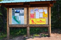
I wonder if we can have a fire?...
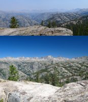
The trail slowly climbs for the first 5 miles. We hiked until we came to Photographers Point (4.5 miles from TH) where we stopped and had lunch and took some pics. The view would have been great if it wasn't for the smoke!
The top photo was this year and the bottom 2 years ago.
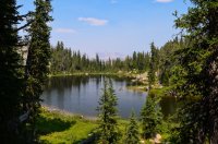
After eating and resting we continued on until Eklund Lake (5.5 miles from TH) where we turned north. Up until this point I was hiking the same trail I had hiked 2 years ago, from now on it was all new! Very soon after Eklund (.25 miles) we came to Barbara Lake (5.75 miles from TH).
Barbara Lake
A steep section of trail.
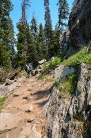
Soon after Barbara the trail goes up and down and up and down and up and down all the way to Seneca Lake...
Here's a nice view to the west right before dropping down in the meadow in the following pic.
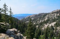
Here the trail drops down into the meadow and then up and out and then back down into Hobbs Lake.
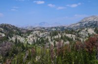
At about 7 miles in we hit Hobbs Lake. It's a very pretty lake and I thought it would be a great place to camp. Two days later on the way out, we watched a guy pull a really nice rainbow out of this lake! It was probably 15" and FAT!
Hobbs Lake

The trail then climbs and drops and few more times before dropping down and crossing the outlet below (way below) Seneca Lake. Then the trail climbs and drops way down again. Then it's up up up (400' elevation in 3/4 mile) to the ridge above Seneca Lake (9 miles in). This was by far the worst part of the trail. We were dead tired by the time we made it to the ridge. Unfortunately there was no level place to camp until the north end of the lake, so we continued down (190' elevation) and almost another mile to the north end of the lake (9.75 miles in).
We luckily found a good campsite near the lake and setup camp (there were a half dozen or more camped at Seneca, all on the north end). As soon as our tents were up we headed down and filtered some much needed water (I had ran out of water about 2 miles from camp on the steep climb up to the ridge above Seneca). It had taken us over 7 hours to get to camp (one of the guys had blisters and it slowed us down a lot). After filtering water I sat and relaxed a bit, then we decided to eat dinner. Normally when I go backpacking I have someone to share the 2 serving Mountain House (dehydrated) dinner with, but my friend will eat a whole one himself so I had a full one to myself. After eating about 1/2 of it I wasn't hungry, but my friend said I should try and eat it all to replace my energy. Well, I got about 3/4 of it eaten before it came back up. (Lesson learned: listen to your body, not your friend. LOL!)
(Unfortunately I didn't take a single picture of Seneca Lake or our camp)
Later that evening a campsite about a hundred yards from us fired up a campfire. I had to laugh and thought how could they miss those signs at the trail head?
That night I didn't sleep much, which is typical of my first night. It was awfully warm too. Luckily I had thrown in a beach towel before leaving and used that as a blanket until it got cooler in the middle of the night, then I half draped my sleeping bag over me.
DAY 2:
The next morning we got up and ate breakfast (I was hungry from throwing up half my dinner the night before) and headed out for Titcomb Basin (~6 miles away). The one guy with the blister immediately decided he was not going and turned back to camp.
Wild flowers along the trail
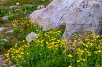
From Seneca Lake we hiked up and past this small unnamed lake/pond. The reflection in the water was great!
Unnamed pond
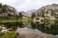
The trail then goes past Little Seneca Lake, then past a small lake/pond that you can see in the next photo. At this small lake is where the trail over Lester Pass connects in. This is the trail that nick and audraiam took from the Cook Lakes on their trip in July.
View looking back along trail we'd just traveled. The lady in the red was backpacking solo, going from Big Sandy to Green River Lakes (nearly 80 miles).
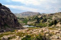
Another valley to drop into and climb out. That is Fremont peak just left of center (3rd highest peak in WY at 13,745'; 64' lower than Gannett and 30' lower than the Grand Teton).
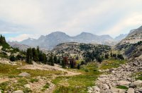
After climbing out of the valley in the photo above, we reached the highest point of this trip (10,640'). The trail then drops down to Island Lake (2 miles from camp). From here, Fremont looks to be impossible to climb. In fact we were all calling bull- on another friend who says he's climbed it! We were later corrected by a couple we met down the trail who had climbed it the day before and said it looks very intimidating, but once your on it it's not that bad (class 3).
Island Lake. Fremont peak just right of center. Titcomb Basin sits below it and runs to the left (north).
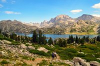
I really liked Island Lake. It was my favorite lake of the trip! In this photo you can see back into Titcomb Basin and Titcomb Creek dumping into Island Lake!
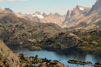
Wild flowers along Island Lake
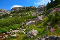
More flowers

Island lake is just gorgeous! I really liked this sandy beach along the lake!

After following the trail along the south end of the lake we cut off trail over to Titcomb Creek where it dumps into Island Lake. From there we fished the stream up to Titcomb Basin. Titcomb creek is so beautiful!!! There are these small falls all the way up into the Basin!!
Titcomb Creek - Island Lake is visible on the left

Titcomb Creek with Fremont Peak
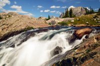
There's Gold in them hills!
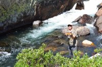
Fishing Titcomb Creek

Getting closer to Titcomb Basin!
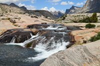
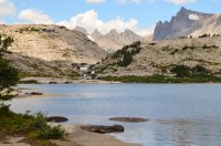
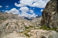
We had finally made it to the beginning of the Basin! We'd gone about 5 miles today and just didn't have the energy to keep going to the lower Titcomb Lake. The hike in the first day took too much out of us. We made it to the edge of the small lake you can see (Titcomb 3) before turning back.
Titcomb Basin

Island Lake, Titcomb Creek and Titcomb Basin are very pretty! It's easy to see why so many people where up there (there were a lot). On the way back we fished Titcomb Creek back down to Island and then we joined up the trail and hiked back to camp. A few dark clouds had been brewing to the west during the afternoon and we got sprinkled on a couple times on the hike back to camp, but nothing worth getting the rain jacket out for. Soon after getting to camp it rained pretty hard for about 20 minutes. After sheltering the rain in our tents we climbed out and made dinner. Later that evening, just after dark, another thunderstorm came through. This one lasted longer and had some hail with it. We all dove into our tents when it started and ended up going to sleep after a while. It was much cooler this night and I slept much better!
DAY 3:
The next morning I got up about 7:15 and started to pack up to head out. I was going to be heading out solo and the others would be staying another day. The night before there had been some discussion about everyone heading out with me. The guy with the blister problems really wanted to leave. He ended up talking the others into leaving with me that morning. We didn't get all packed up and heading out until about 9:30 (I had planned to be on the trail by 8-8:30).
The hike out was uneventful and we eventually made it to photographers point. I pulled out my cell phone and turned it on and was glad to see I had a signal. I sent of a text message to my parents letting them know I was running behind schedule and would be out in 2-3 hours. They were expecting me to call them from Pinedale about the time we hit photographers point. After eating some food and resting for a bit we headed on out. It took us about 5 hours to hike out. We drove down to Pinedale and ate at Wind River Pizza. It was good, but I remember it being much better when I ate there 2 years ago. After some food we headed on our way home...
EPILOGUE:
All-in-all it was a good trip. It was way too much hiking for me in 3 days though! I figure we did 30+ miles, with almost 20 of those miles with packs on. I'm just not at hard core as some of the others on here... Now that I've been home over a week I am ready to go back! My friends are wanting to go in next year and climb Fremont... I think I'll stay and fish Mistake Lake instead... I still need to see those upper and lower Titcomb Lakes! Wished I would have pressed on... Oh well... Next time!
Featured image for home page:
Titcomb Basin has been on my "to see" list for a pretty much ever since I started backpacking. So when my buddy called me up and said he's going into Titcomb this year I jumped at the chance! We set it up for Wednesday through Sunday. As things got closer people started to drop out and it was soon down to 5 (about the right number IMHO) going. Then I was faced with a very tough decision of having to drop out myself! My sister had moved her wedding date up a week to the weekend we'd be in Titcomb! Everyone, including her, was telling me to go because I had this planned for nearly 6 months. Well, the more I thought about it the more guilty I knew I would feel while up in there in the wilderness. So I decided that I would hike out solo on Friday to make the wedding Saturday. At first my family was against this as they didn't think it was wise to hike alone. But I informed them that it was one of the busiest trails in the Winds, it was a Friday and there would be lots of people hiking in (turned out there wasn't as much as when we went in), and I had my cell phone and 30 mile radio with me. This convinced them and I was still in!!!!
About 4 days before the trip, one of the guys had to bail. So it was down to 4 of us. My buddy and I would be driving from Cache Valley and meeting the two others from SLC in Pinedale. I would head out Friday alone and the guys from SLC and my buddy would head out Saturday as the two from SLC had to be home Saturday.
DAY 1:
I left my house about 5:30am Wednesday and drove over and picked up my friend. We made it to the summit above Bear Lake just after the sun had come up. The sun was red from all the forest fire smoke. We stopped and snapped a few photos.
Sunrise over a smokey Bear Lake - I haven't touched up this photo at all.

When we got to Pinedale you could barely see the Wind River range due to the smoke (didn't take a pic). Usually you can see it just north of Kemmerer. We met up with the other two guys who had driven from SLC and headed up to the trail head (Elkhart Park). We were on the trail hiking by 10:30am. This is the same trail head we used when I went into the Cook Lakes 2 years ago.
I wonder if we can have a fire?...

The trail slowly climbs for the first 5 miles. We hiked until we came to Photographers Point (4.5 miles from TH) where we stopped and had lunch and took some pics. The view would have been great if it wasn't for the smoke!
The top photo was this year and the bottom 2 years ago.

After eating and resting we continued on until Eklund Lake (5.5 miles from TH) where we turned north. Up until this point I was hiking the same trail I had hiked 2 years ago, from now on it was all new!
Barbara Lake

A steep section of trail.

Soon after Barbara the trail goes up and down and up and down and up and down all the way to Seneca Lake...
Here's a nice view to the west right before dropping down in the meadow in the following pic.

Here the trail drops down into the meadow and then up and out and then back down into Hobbs Lake.

At about 7 miles in we hit Hobbs Lake. It's a very pretty lake and I thought it would be a great place to camp. Two days later on the way out, we watched a guy pull a really nice rainbow out of this lake! It was probably 15" and FAT!
Hobbs Lake

The trail then climbs and drops and few more times before dropping down and crossing the outlet below (way below) Seneca Lake. Then the trail climbs and drops way down again. Then it's up up up (400' elevation in 3/4 mile) to the ridge above Seneca Lake (9 miles in). This was by far the worst part of the trail. We were dead tired by the time we made it to the ridge. Unfortunately there was no level place to camp until the north end of the lake, so we continued down (190' elevation) and almost another mile to the north end of the lake (9.75 miles in).
We luckily found a good campsite near the lake and setup camp (there were a half dozen or more camped at Seneca, all on the north end). As soon as our tents were up we headed down and filtered some much needed water (I had ran out of water about 2 miles from camp on the steep climb up to the ridge above Seneca). It had taken us over 7 hours to get to camp (one of the guys had blisters and it slowed us down a lot). After filtering water I sat and relaxed a bit, then we decided to eat dinner. Normally when I go backpacking I have someone to share the 2 serving Mountain House (dehydrated) dinner with, but my friend will eat a whole one himself so I had a full one to myself. After eating about 1/2 of it I wasn't hungry, but my friend said I should try and eat it all to replace my energy. Well, I got about 3/4 of it eaten before it came back up. (Lesson learned: listen to your body, not your friend. LOL!)
(Unfortunately I didn't take a single picture of Seneca Lake or our camp)
Later that evening a campsite about a hundred yards from us fired up a campfire. I had to laugh and thought how could they miss those signs at the trail head?
That night I didn't sleep much, which is typical of my first night. It was awfully warm too. Luckily I had thrown in a beach towel before leaving and used that as a blanket until it got cooler in the middle of the night, then I half draped my sleeping bag over me.
DAY 2:
The next morning we got up and ate breakfast (I was hungry from throwing up half my dinner the night before) and headed out for Titcomb Basin (~6 miles away). The one guy with the blister immediately decided he was not going and turned back to camp.
Wild flowers along the trail

From Seneca Lake we hiked up and past this small unnamed lake/pond. The reflection in the water was great!
Unnamed pond

The trail then goes past Little Seneca Lake, then past a small lake/pond that you can see in the next photo. At this small lake is where the trail over Lester Pass connects in. This is the trail that nick and audraiam took from the Cook Lakes on their trip in July.
View looking back along trail we'd just traveled. The lady in the red was backpacking solo, going from Big Sandy to Green River Lakes (nearly 80 miles).

Another valley to drop into and climb out. That is Fremont peak just left of center (3rd highest peak in WY at 13,745'; 64' lower than Gannett and 30' lower than the Grand Teton).

After climbing out of the valley in the photo above, we reached the highest point of this trip (10,640'). The trail then drops down to Island Lake (2 miles from camp). From here, Fremont looks to be impossible to climb. In fact we were all calling bull-
Island Lake. Fremont peak just right of center. Titcomb Basin sits below it and runs to the left (north).

I really liked Island Lake. It was my favorite lake of the trip! In this photo you can see back into Titcomb Basin and Titcomb Creek dumping into Island Lake!

Wild flowers along Island Lake

More flowers

Island lake is just gorgeous! I really liked this sandy beach along the lake!

After following the trail along the south end of the lake we cut off trail over to Titcomb Creek where it dumps into Island Lake. From there we fished the stream up to Titcomb Basin. Titcomb creek is so beautiful!!! There are these small falls all the way up into the Basin!!
Titcomb Creek - Island Lake is visible on the left

Titcomb Creek with Fremont Peak

There's Gold in them hills!

Fishing Titcomb Creek

Getting closer to Titcomb Basin!


We had finally made it to the beginning of the Basin! We'd gone about 5 miles today and just didn't have the energy to keep going to the lower Titcomb Lake. The hike in the first day took too much out of us. We made it to the edge of the small lake you can see (Titcomb 3) before turning back.
Titcomb Basin

Island Lake, Titcomb Creek and Titcomb Basin are very pretty! It's easy to see why so many people where up there (there were a lot). On the way back we fished Titcomb Creek back down to Island and then we joined up the trail and hiked back to camp. A few dark clouds had been brewing to the west during the afternoon and we got sprinkled on a couple times on the hike back to camp, but nothing worth getting the rain jacket out for. Soon after getting to camp it rained pretty hard for about 20 minutes. After sheltering the rain in our tents we climbed out and made dinner. Later that evening, just after dark, another thunderstorm came through. This one lasted longer and had some hail with it. We all dove into our tents when it started and ended up going to sleep after a while. It was much cooler this night and I slept much better!
DAY 3:
The next morning I got up about 7:15 and started to pack up to head out. I was going to be heading out solo and the others would be staying another day. The night before there had been some discussion about everyone heading out with me. The guy with the blister problems really wanted to leave. He ended up talking the others into leaving with me that morning. We didn't get all packed up and heading out until about 9:30 (I had planned to be on the trail by 8-8:30).
The hike out was uneventful and we eventually made it to photographers point. I pulled out my cell phone and turned it on and was glad to see I had a signal. I sent of a text message to my parents letting them know I was running behind schedule and would be out in 2-3 hours. They were expecting me to call them from Pinedale about the time we hit photographers point. After eating some food and resting for a bit we headed on out. It took us about 5 hours to hike out. We drove down to Pinedale and ate at Wind River Pizza. It was good, but I remember it being much better when I ate there 2 years ago. After some food we headed on our way home...
EPILOGUE:
All-in-all it was a good trip. It was way too much hiking for me in 3 days though! I figure we did 30+ miles, with almost 20 of those miles with packs on. I'm just not at hard core as some of the others on here... Now that I've been home over a week I am ready to go back! My friends are wanting to go in next year and climb Fremont... I think I'll stay and fish Mistake Lake instead...
Featured image for home page:

