White Pocket, South Coyote Buttes Advice

pixie1339

Desperately Seeking Sandstone
Joined
Jan 21, 2012
Messages
1,692
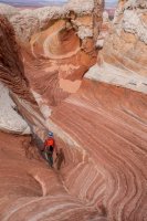
I'm having some anxiety and I could use a little advice from people that know these roads. I'm leaving later on this afternoon for the Coyote Buttes area. I have permits for Coyote Buttes North on Saturday and permits for Coyote Buttes South on Sunday and Monday. I've been planning to go to White Pocket tomorrow. Here's the kicker, though. I will be alone. I could only get one permit for each day. I originally thought I'd have a a tour guide take me to White Pocket and Coyote Buttes South, but they all have a two person minimum, and I don't have enough money to pay for two. Ultimately I decided to go anyway, but I was hoping that the winter moisture would make the roads easier to drive. I called the Kanab BLM office yesterday to ask about road conditions to White Pocket and Coyote Buttes South, and the ranger said they haven't had any moisture down there since September, so there's a lot of deep sand. He referred to it as "fluffy" which did not instill confidence in me. He said people are still making it out there though. I will have an InReach, a set of MaxTrax, an air compressor, a shovel, and a tow strap, but I'm trying to decide if I should even try for White Pocket. I'd hate to get stuck there and miss Coyote Buttes North the next day. I'm not as worried about Coyote Buttes South because driving to Paw Hole is not very far. If the drive there freaks me out, I'll have my backpacking gear with me and can hike from Paw Hole to Cottonwood, and back the next day. Thoughts?
 
I was just in the area this past weekend, but did not go out to White Pocket on this trip, so I have no info on that route. The drive to Paw Hole was soft in places, but nothing too difficult. I drove to Cottonwood Cove from the Paw Hole trailhead which was very sandy and deep in places. I wouldn't recommend going this way if you are worried about deep sand. I met my friend Terry in Kanab before heading home and he had driven out to Cottonwood Cove from a different route further south that is supposed to be easier than the way I went, and he said it was in good shape.

Not sure if any of this helps, but it's all I got. It's definitely dry out there!
 
It sounds like you've got the right stuff to get you out if you hit the sand. If you don't already, it could be good to have something to build an anchor to winch from. I keep a couple of 3' concrete stakes in my truck that I would make an X with and pound into the sand. Not sure if it woudl work but it's better than sage brush.

My advice, keep the pedal to the metal and you'll be fine. I've heard the road coming in from the south to White Pocket is better than the north but I haven't been in that way.

The drive to Paw Hole was not a problem at all, in my opinion.
 
I have driven both ways to White Pocket (thru Paw Hole & the South route via Pine Tree Rd).
As Nick & Randy mentioned I would not recommend the route from Paw Hole to White Pocket as there is deep sand both right after Paw Hole, but also a steep sandy hill close to White Pocket.
Alternately the southern route is fairly easy and should not present any problems. 2-Wheel drive with normal SUV clearance.
I have encountered vehicles on this route each of the 3 times I have driven it, so worst case eventually someone will come by :)

The one other thing I wanted to bring up is that travel times on the Plateau is fairly slow. So even if you wake up early and leave White Pocket, it will probably take you ~1.5hr to get to Wire Pass TH for CBN the next morning. That might cut into your time at CBN? Something to think about.. If you don't plan to visit White Pocket in the morning of your CBN hike, I would personally drive out after sunset and camp closer to Wire Pass.

Have fun!.. I am jealous.
 
Thanks for the input guys! I did go, and thankfully I didn't have any issues getting stuck. I think it had just been drilled into my head so many times to not go out onto those roads alone, that I started to get a little unnerved when the time came to actually go. Once I deflated my tires it was smooth sailing. I actually kind of enjoyed driving in the sand. It was easier to drive on than the rocky parts. Now that I know I can make it to CBS and White Pocket in my 4Runner, I will definitely be returning, and hopefully with some company next time. :cool:
 
I went alone to White Pocket in November in a Subaru. People out there were acting like I was crazy but honestly, the southern route wasn’t so bad.
 
Great to hear all this, I'm doing a Kanab-based trip soon and was thinking about taking my family out to White Pocket.
 
Went out to White Pocket today using the southern route. It wasn't a hard drive, but felt pretty long to my wife and kids. I didn't bother airing down the tires. The ruts in the sand were deep enough that the skid plates on my 4runner scraped the sand in places, so I'd definitely have not been comfortable out there in a vehicle with less clearance.

Such a cool area! But lots of toilet paper in the brush near the parking area, how disgusting.

DSC04464.jpg
 
Similar threads
Thread starter Title Forum Replies Date
Janice Vermillion Cliffs Trip - Part 2 - White Pocket & Coyote Buttes South Hiking & Camping 7
Janice The Wave - and SO MUCH MORE! (Coyote Buttes North, South, White Pocket, Buckskin, Condors, Bighorns...) - Part 1 Hiking & Camping 14
D South Coyote Buttes. We are going to put in at Lone Tree Reservoir because we don't have 4wd but we want to make it to White Pocket. Trip Planning 30
C white pocket hike, South Coyote Buttes Trip Planning 16
D Late March 2013 trip to White Pocket, North and South Coyote Buttes Hiking & Camping 2
rhubarrbb White Pocket - Lone Tree Road / Southern Road Trip Planning 3
J Great to be here! Heading to White Pocket next month... Noobs: Introduce yourself! 8
P Invite White Pocket mid August Meet Up (Members Only) 4
Dirkules White Pocket to CBS Trip Planning 5
John Fowler White Pocket, Coyote Buttes, and Toprock Hiking & Camping 12
Bill White Pocket 10.2012 Hiking & Camping 7
ROKTAXI White Pocket, The Wave & Alstrom Point Hiking & Camping 9
IntrepidXJ An Evening at The White Pocket Hiking & Camping 14
jdgibney The Wave/White Pocket Fri Oct 12 permits for a ride? Trip Planning 1
Bill White Pocket Access... Trip Planning 4
IntrepidXJ The White Pocket Hiking & Camping 4
John Fowler White Pocket 360 Photography 3
Nick White Pocket, January 2011 Hiking & Camping 3
Seldom Seen Anderson White Pocket Hiking & Camping 13
Writhdar Day hikes in the White Clouds and Lost River Range Hiking & Camping 1
LarryBoy Is there anything technical in White Canyon above the Black Hole? Trip Planning 16
NorthwestWanderer Backpacking Idaho's Cecil D. Andrus-White Clouds Wilderness : O'Calkens Lake & Bighorn Basin Backpacking 2
D White Rim Road Off Road 2
Parma White Rim Road FKT General Discussion 4
IntrepidXJ Diane’s Birthday Ride on the White Rim Trail Everything Else 3
Dhuff3243 Robbers Roost/White Roost Trip Planning 1
Nick Who wants to have 2 nights at White Crack in March? General Discussion 0
Parma Idaho's White Cloud Mountains - Boulder Chain Lakes - Chamberlain Basin Backpacking 8
misSOULa Six days in the Bob Marshall Wilderness: The Chinese Wall and White River Backpacking 15
Ugly Another Friday Night... White Winter Sports 7
fossana solo white rim day trip on the dual sport Off Road 11
S Two weeks in the White Clouds, Idaho, July 2018 Backpacking 6
MVS White Rim Side Roads Trip Planning 4
RyanP White Rim Road vehicle/difficulty questions Trip Planning 8
Ugly Saturday in Black and White, with a smudge of Green Hiking & Camping 3
J White Cloud Route. 2018 June 22 Trip Planning 3
Glasterpiece White Sands NM General Discussion 9
Vegan.Hiker White Mountain National Forest (Eisenhower, Pierce, Jackson) - May 2018 Backpacking 15
Ugly Mill D - Fresh White Milkshake Covered Desolation Winter Sports 15
MVS White Rim General Discussion 10
Nanda White rim in March Trip Planning 3
Nick White Canyon Tributaries Trip Planning 3
George_Washington_Hayduke White Roost Canyons (east and west forks) & North Fork of Robbers Roost Canyon Canyoneering 3
powderglut Toadstools and Hoodoos in the White Rock Valley Hiking & Camping 8
Rockskipper White moose in Sweden General Discussion 2
S White Cloud route, Big Boulder Lakes to Boulder Chain Lakes Trip Planning 3
Eugene Paria Canyon from White House to Big Spring Backpacking 3
George_Washington_Hayduke Clearwater Canyon, Black Hole of White Canyon, Dark Canyon, Swett Canyon "Packraftoneering" Canyoneering 6
DrNed White River In Colorado Trip Planning 6
isleroyaleguy White Clouds maps? Trip Planning 4

Similar threads

Back
Top