Navigation
Install the app
How to install the app on iOS
Follow along with the video below to see how to install our site as a web app on your home screen.
Note: This feature may not be available in some browsers.
More options
Style variation
You are using an out of date browser. It may not display this or other websites correctly.
You should upgrade or use an alternative browser.
You should upgrade or use an alternative browser.
Where is this?
- Thread starter Devo
- Start date
Udink
Still right here.
- Joined
- Jan 17, 2012
- Messages
- 1,742
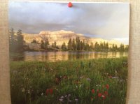
I believe that's Hayden Peak taken from somewhere near Ryder Lake. Here's a photo I found in Panoramio that looks like it was taken from about the same spot: http://www.panoramio.com/photo/8343285
- Joined
- Aug 9, 2007
- Messages
- 12,960
Yep. Definitely Middle Basin and Hayden. I'm thinking the it's from the SW shore of BR-17, but I'm not totally sure. Here: 40.721487, -110.828871
EDIT: After looking through my pics, I'm pretty sure it is NOT BR-17 now, but definitely something in that basin.
EDIT: After looking through my pics, I'm pretty sure it is NOT BR-17 now, but definitely something in that basin.
Zep
Member
- Joined
- Jun 19, 2012
- Messages
- 13
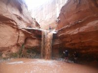
Not to hijack the Uintas photo, but I've got a similar question about the whereabouts of the below photo. I know it's in Utah... down south somewhere, but don't know the name of the area/canyon. I'm sure someone here will know the spot. I know there are 4-5 small rappels and eventually the canyon dumps into the Dirty Devil. Can anyone tell me the name of the canyon/route/hike?
Zep

Zep

- Joined
- Aug 9, 2007
- Messages
- 12,960
I like this thread. A place to post photos where people legitimately want to know where a place is! 
I'm guessing that is not a perennial stream? Looks more like a flood. Do you know if those rappels are close to the Dirty D or way up high in the canyon?
I'm guessing that is not a perennial stream? Looks more like a flood. Do you know if those rappels are close to the Dirty D or way up high in the canyon?
Udink
Still right here.
- Joined
- Jan 17, 2012
- Messages
- 1,742
South Fork Robbers Roost. Check out Day 6 here, very last photo is the same rappel: http://www.tumtum.com/climbing/trips/RobersRoost97_part2.shtml
- Joined
- Aug 9, 2007
- Messages
- 12,960
South Fork Robbers Roost. Check out Day 6 here, very last photo is the same rappel: http://www.tumtum.com/climbing/trips/RobersRoost97_part2.shtml
Dude... how did you do that?!
Udink
Still right here.
- Joined
- Jan 17, 2012
- Messages
- 1,742
I'm a little fuzzy on the detailsDude... how did you do that?!
Devo
Member
- Joined
- Mar 1, 2014
- Messages
- 152
View attachment 16767
I have a Mountain America Credit Union calendar and this is what I found when I flipped it over to May. All it says is High Unitas, I am sure someone knows where this is. I am curious, thanks!
So after seeing @pixie1339 post a picture of Naomi lake in the bag night challenge, I think this has to in fact be Naomi Lake, thank you for inadvertently solving this Pixie!
Don't like ads? Become a BCP Supporting Member and kiss them all goodbye. Click here for more info.

