Water in Escalante?

Joined
Jan 25, 2024
Messages
23
Yo. I did a big 2 week trip in Yellowstone, and honestly? It was a little 'Meh'. I spent most of it wishing I was down in Capitol Reef, because down there everything is spectacular.

So anyways, I got to looking at that good old satellite footage, and my eyes started straying to the canyon complexes west of Halls Creek. The suicidal monkey in my head started jumping and clapping, because it thinks that area looks pretty swell. Generally speaking, it looks like some pretty good-grade slickrock, with lots of promising nooks and crags that I'm dying to get my teeth into, but water availability makes me pause. Having hiked several years in capitol reef, I'm pretty familiar with the slickrock and all the pot-hole water goodness of the area, but the escalante canyons seem a bit of a different beast.

I'm asking for specific geo-coordinates (but I'll take them if you'll give). But I'd like to know, more or less, where I can find good water in this area.

Where are the year-round streams? The seasonal streams? Potholes? How long do those potholes last after rain? What's the flavor of the terrain? Where can I get more information about the area?

Anything you're willing to toss my way would be appreciated.

 
I'm asking for specific geo-coordinates (but I'll take them if you'll give). But I'd like to know, more or less, where I can find good water in this area.


Freudian slip?


If you can be more specific in your request, you will have more success getting answers.

Fountain Tanks near Halls typically has water, as does Muley Tanks IIRC. Both could have beta perhaps on the Hayduke Trail FB page. We walked from Halls Creek overlook->Baker->out Coyote via Stevens in May, and indeed the Fountain Tanks had quite a bit of water at that time. There was also good water coming out of Millers. Halls itself is having an algae bloom issue, not a good source past the narrows, but you could ask the park service if it's still an issue. I believe the algae issue begins in the narrows, so any flowing water north of it would be fine.

Going up the Baker Route, there were occasional potholes, but this was back in May, and it also rained on us heading up the route. I would not count on it. Jamal's site (Across Utah) may have more information on specific canyons.
 
It would be helpful if you were more specific as to which area west of Hall's Creek you are interested in, as the creek passes through a lot of territory and the water situation varies as you go north to south.
 
Yes to potholes. That zone is convoluted and difficult to navigate. Slope angle shading can be deceptive as unshaded areas on that bare slickrock can be extremely steep and often impassible. There are routes through there however and the Waterpocket Fold is an amazing place to explore, and it can hold quite a bit of water especially after rains. Be advised that area is known for Technical canyons and keeper potholes and the drainages above the Narrows end in huge drops. It makes sense to familiarize yourself with the technical canyons by visiting some canyoneering sites (might find some beta as well), however there are numerous unpublished technical canyons in the Fold. Exploring upcanyon vs downcanyon is a smart move always keeping the ability to backtrack to an escape route or water. This is not the area to take committing backpacking routes. You might find a potshot or pack toss with some rope or webbing useful for exploring up some of the narrows. Enjoy.
 
Freudian slip?
More like an "I wrote this while super tired slip". Regardless, apologies for taking so long to get back to you. My life has taken a rather busy turn, and I kept procrastinating on checking the forum.

EDIT: Gosh, that Across Utah website you pointed me at is fantastic.
It would be helpful if you were more specific as to which area west of Hall's Creek you are interested in, as the creek passes through a lot of territory and the water situation varies as you go north to south.
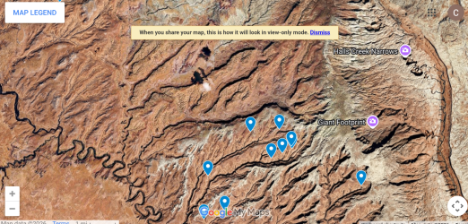
Capture.PNG
Don't mind the pins. They're showing where I think I might be able to find water, but regardless, this sorta showcases the area I am currently looking at. I honestly don't know much about the Escalante. I'm open to anything, but barring some really interesting new information, I'll probably be nosing around in the areas near these pins, and going south of them closer to Lake Powell.

I like my water.
Yes to potholes. That zone is convoluted and difficult to navigate. Slope angle shading can be deceptive as unshaded areas on that bare slickrock can be extremely steep and often impassible. There are routes through there however and the Waterpocket Fold is an amazing place to explore, and it can hold quite a bit of water especially after rains. Be advised that area is known for Technical canyons and keeper potholes and the drainages above the Narrows end in huge drops. It makes sense to familiarize yourself with the technical canyons by visiting some canyoneering sites (might find some beta as well), however there are numerous unpublished technical canyons in the Fold. Exploring upcanyon vs downcanyon is a smart move always keeping the ability to backtrack to an escape route or water. This is not the area to take committing backpacking routes. You might find a potshot or pack toss with some rope or webbing useful for exploring up some of the narrows. Enjoy.
This is all very good information. Thank you.

I'll probably plan to bounce back to Capitol Reef if things don't work out here, and I will absolutely take you up on your advice to look at the technical climbing forums.
 
Last edited:
Back
Top